|
This page currently shows what I know about Florida. Index data (numbers on the left edge) are from the List of ALL Existing U.S. Lighthouses by Bob and Sandra Shanklin p2 Directions are courtesy of Lighthouse Friends, sometimes updated from personal experience. w4 |
|
| FL 1 |
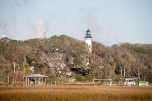
Amelia Island
latitude 30° 40' 23" N longitude 81° 26' 33.8" W
February 5, 2018 access: car + view or tour
From Interstate 95 take Exit 375, and drive east on SR 200 onto Amelia Island. Follow SR 200 as it turns north to Fernandina Beach. Continue into the historic district then turn right on Atlantic Avenue (A1A). Views of the light can be had from Atlantic Avenue, but better views come from Fort Clinch State Park. Fort Clinch
Tours of the lighthouse are offered by the City of Fernandina Beach on the first and third Wednesdays of the month. For more information call: (904) 310-3350. The grounds surrounding Amelia Island Lighthouse property are open to the public for viewing on Saturdays from 11 a.m. to 2 p.m. At other times, access to the lighthouse grounds is restricted. (J 2856) ARLHS # USA-010 |
|
| FL 2 |
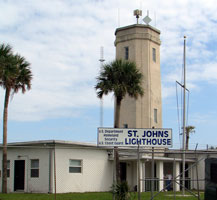
| St. Johns River
latitude 30° 23' 31.5" N longitude 81° 25' 31.8" W
access: car
Located inside Naval Station Mayport on the west side of the runway near Mayport and the ferry crossing. Mayport
The base is closed to the public. However a person who is serving or has served can act as your sponsor. Contact the Visitors center at (904) 270-5585 to discuss how being sponsored works. (J 2858) ARLHS # USA-795
Photo courtesy Donna McCraw [Flickr] |
| FL 3 |
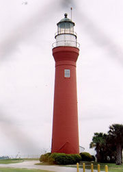
Mayport
latitude 30° 23' 36.6" N longitude 81° 25' 33.3" W
access: car
Very near the above light. ARLHS # USA-796
Photo courtesy Thom Perry [Flickr] |
|
| FL 4 |
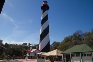
| St. Augustine
latitude 29° 53' 7.6" N longitude 81° 17' 18.2" W
February 5, 2018 access: car
From the North, take Exit 318 from Interstate 95 and travel east on SR 16 for 5.5 miles. Turn right on San Marcos Avenue (just after U.S. 1) and travel south. San Marcos Avenue will pass Castillo de San Marcos and become A1A. Take the Bridge of Lions over the river and continue on A1A. Turn left onto Red Cox Road. (J 2866) ARLHS # USA-789 |
| FL 5 |
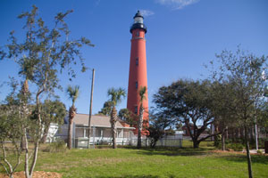
Ponce Inlet
latitude 29° 4' 50.1" N longitude 80° 55' 40.9" W
February 6, 2018 access: car
From Interstate 95, take exit 256 and go east on Dunlawton Avenue for 3.8 miles to the intersection with Highway 1. Take the bridge across the Halifax River. At the second traffic light, turn right on Atlantic Avenue and drive south for 5.3 miles to the four-way stop at Beach Street. Turn right on Beach Street and then left on Peninsula Drive. World Lighthouse Society (J 2877) ARLHS # USA-644 |
|
| FL 5A |
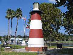
| Mount Dora
access: car
The only inland lighthouse in Florida.
Photo courtesy Donna McCraw [Flickr] |
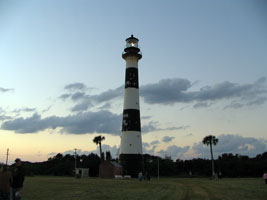
| FL 6 |
Port Canaveral
latitude 28° 27' 37.4" N longitude 80° 32' 36.6" W
access: tour
There are certain tours offered by the Kennedy Space Center which pass by the lighthouse. Space Center (J 2888) ARLHS # USA-108
Photo courtesy Donna McCraw [Flickr] |
|
| FL 7 |
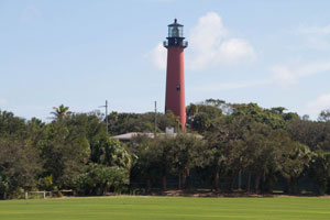
| Jupiter
latitude 26° 56' 55.3" N longitude 80° 4' 54.8" W
February 9, 2018 access: car
Take Highway 1 to the northern side of the river in Jupiter. Turn right (east) at Beach Road and then right on Captain Armours Way into Jupiter Lighthouse Park.
To get close to the lighthouse, you need to take a guided tour as you are on government property. (J 2922) ARLHS # USA-411 |
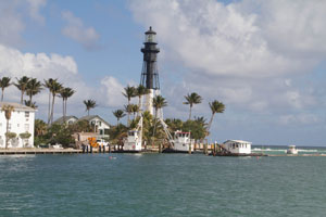
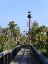
| FL 8 |
Hillsborough Inlet
latitude 26° 15' 33" N longitude 80° 4' 50.8" W
February 9, 2018 access: car + walk
From Interstate 95 in Pompano Beach, take exit 35 and drive east on Copans Road for just over 2 miles to Federal Highway (Highway 1). Travel south on Federal Highway for just over a half mile to 14th Street (Highway 844). Go east on 14th Street for a mile then turn right on Highway A1A. Turn left onto 16th street and park at the end of the street, from where you can walk the beach to get a good view of the lighthouse lighthouse
This picture was taken after we crossed the bridge on A1A
ARLHS # USA-372 |
|
|
|
| FL 9 |
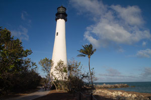
| Cape Florida
latitude 25° 39' 60" N longitude 80° 9' 20.9" W
February 9, 2018 access: car
From the southern end of Interstate 95 in Miami, take exit 1 and go south on the Rickenbacker Causeway to Key Biscayne. Rickenbacker Causeway will become Crandon Boulevard, which you can follow to Bill Baggs Cape Florida State Park at the southern end of Key Biscayne CapeFlorida (J 2956.4) ARLHS # USA-118 |
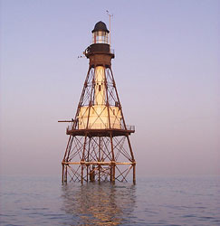
| FL 10 |
Fowey Rocks
access: boat
Very distant views of the Fowey Rocks Lighthouse are possible from the Cape Florida Lighthouse. However, the best views come by boat or plane. One can fly over the lighthouse with Benoit Courbin of Dean International Inc. The flights depart from Tamiami Airport southwest of Miami. FlyMiami ARLHS # USA-307
Photo courtesy Eddie Dziura [key-biscayne] |
|
| FL 11 |
| Carysfort Reef
latitude 25° 13' 18.8" N longitude 80° 12' 41.3" W
access: boat or car + view
To get a distant view of the Carysfort Reef Lighthouse from land, at the intersection of Highway 1 and County Road 905 on Largo Key, proceed northeast on County Road 905. The lighthouse will be directly offshore from you after roughly seven miles. ARLHS # USA-143
Photo courtesy Roger Bansemer [webGallery] |
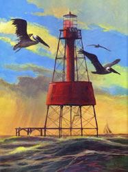
| FL 12 |
Alligator Reef
access: boat
Distant views of the Alligator Reef Lighthouse are possible from Highway 1 between Mile Markers 77 and 80. ARLHS # USA-006
Photo courtesy John Ames/P J McCann [Flickr] |
|
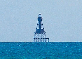
| FL 13 |
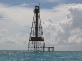
| Sombrero Key
latitude 24° 37' 40.1" N longitude 81° 6' 39.6" W
access: boat or car + view
A distant view is possible from the eastern end of the 7-mile bridge near Marathon or from Sombrero Beach. Sombrero Beach
To reach Sombrero Beach, turn south on Sombrero Beach Boulevard at Mile Marker 50 in Marathon and follow the road for two miles to the beach, where you will find a nice park and a decent view of the lighthouse ARLHS # USA-768
Photo courtesy Travis Lide [Flickr] |
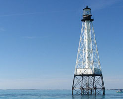
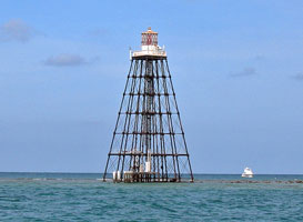
| FL 14 |
American Shoals
access: boat or car + view
For a distant view of the lighthouse from land, turn south onto Sugarload Boulevard from the Overseas Highway at Mile Marker 17. When the road tees after 2.6 miles, turn right and drive 2.5 miles to a small bridge over Sugarload Creek from where you can see the lighthouse on a clear day.
(and heavily zoomed in my editor) ARLHS # USA-011
Photo courtesy Patti Schmidt [Flickr] |
|
| FL 15 |
| Sand Key
access: plane
The reefs around the lighthouse are a popular snorkeling destination from Key West. One can also fly over the lighthouse with Fantasy Dan's Airplane Rides, located at the Sugarloaf Airport near MM 17. Fantasy Dan's can be reached at (305) 745-2217. (J 3006) ARLHS # USA-724
Photo courtesy Donna McCraw [Flickr] |
|
|
| FL 16 |
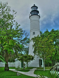
Key West
latitude 24° 33' 2.4" N longitude 81° 48' 3.2" W
access: car
From Miami take Highway 1 to Key West, a distance of roughly 125 miles. Highway 1 will take you into the city of Key West, where it is also known as North Roosevelt and then Truman Avenue. Continue on Truman Avenue past Whitehead Street to the light. lighthouse ARLHS # USA-420
Photo courtesy Claudia Domenig [Flickr] |
|
| FL 17 |
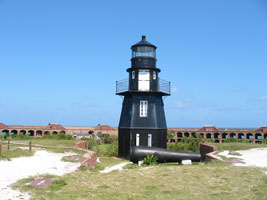
| Fort Jefferson , Dry Tortugas
latitude 24° 37' 41.6" N longitude 82° 52' 20.3" W
access: ferry
Dry Tortugas National Park can be reached by ferry via Sunny Days and Yankee Fleet. You can walk around the top of the fort and get a good view of the lighthouse ARLHS # USA-316
Photo courtesy Donna McCraw [Flickr] |
| FL 18 |
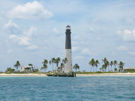
Loggerhead key , Dry Tortugas
latitude 24° 37' 60" N longitude 82° 55' 14.1" W
access: ferry + view
Dry Tortugas National Park can be reached by ferry via Sunny Days and Yankee Fleet, and by seaplane with Seaplanes of Key West. The ferries and seaplanes only provide access to Garden Key, from where a distant view of Loggerhead Key is possible. To land at Loggerhead Key, you must take your own boat or go with a guide who has a permit issued by the park. The pier at Loggerhead Key is closed to the public. Therefore, you must access the island by anchoring offshore and either wading or taking a small boat ashore. (J 3060) ARLHS # USA-236
Photo courtesy Donna McCraw [Flickr] |
|
| FL 19 |
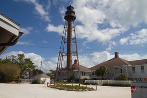
| Sanibel
latitude 26° 27' 10.6" N longitude 82° 51.3" W
February 10, 2018 access: car
From Interstate 75 just south of Fort Myers, take Exit 131 (Daniels Parkway) west to Summerlin Road. Follow Summerlin Road to the Sanibel Causeway, which requires a toll. Drive across the causeway onto Sanibel Island. At the four-way stop sign turn left on Periwinkle Way and follow it to the eastern end of the island. (J 3086) ARLHS # USA-734 |
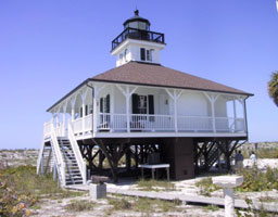
| FL 20 |
Boca Grande Gasparilla Front Range
latitude 26° 43' 1.9" N longitude 82° 15' 39" W
February 11, 2018 access: car
Once on the island, follow the main road towards the southern end of the island. The range light is 1.7 miles from the southern end of the island, alongside Gulf Boulevard. (J 3110) |
|
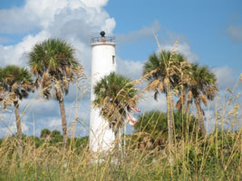
| FL 21 |
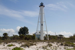
| Gasparilla Rear Range Boca Grande Rear Range
latitude 26° 44' 31.6" N longitude 82° 15' 48.6" W
February 11, 2018 access: car
To get to Gasparilla Island, take the Boca Grande Causeway near the southern end of Highway 775 southwest of Port Charlotte. Once on the island, follow the main road to the southern end of the island where you will find Gasparilla Island State Park and the lighthouse. island (J 3100.1) ARLHS # USA-066 |
| FL 22 |
Egmont Key
latitude 27° 36' 2.8" N longitude 82° 45' 38.5" W
access: boat
Accessible only by private boat. (J 3144) ARLHS # USA-269
Photo courtesy E. James [Flickr] |
|
| FL 22A |
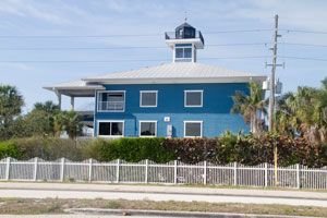
| Tierra Verda Tampa Bay Watch
latitude 27° 39' 17.5" N longitude 82° 43' 4.7" W
February 12, 2018 access: car
The Tampa Bay Watch lighthouse was modeled after the Boca Grande light. The lighthouse is the first privately-held aid to navigation permitted by the United States Coast Guard in Florida in the past 54 years. Bay Watch
When leaving the bridge, follow 997S. Just before the toll station into the Fort, you will find this on the right side of the highway. ARLHS # USA-1335 |
| FL 23 |
Anclote Key
latitude 28° 10' 1.5" N longitude 82° 50' 40.9" W
access: boat
Pontoon boats to get you out to Anclote Key can be rented from Anclote Village Marina near Tarpon Springs. marina (J 3273) ARLHS # USA-013
Photo courtesy Laura Thorne [Flickr] |
|
| FL 24 |
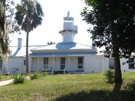
| Cedar Keys (Seahorse Key)
February 7, 2018 access: Tour
Cedar Key Island Hopper offers transportation to the island during the open house and at other times. Landing on Seahorse Key is not permitted from March 1st to July 1st due to bird nesting. Island Hopper ARLHS # USA-745
Photo courtesy Donna McCraw [Flickr] |
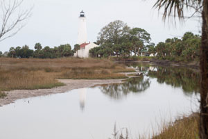
| FL 25 |
St. Marks
latitude 30° 4' 25.8" N longitude 84° 10' 46.8" W
February 12, 2018 access: car
From Highway 98 just east of Newport, turn south onto Lighthouse Road (Highway 59) and follow it for 3.6 miles to the entrance of St. Marks National Wildlife Refuge. After paying the small entrance fee, continue south on Lighthouse Road for another 6.5 miles to the lighthouse. park (J 3300.1) ARLHS # USA-801 |
|
| FL 26 |
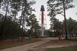
| Crooked River (Carrabelle)
latitude 29° 49' 38.1" N longitude 84° 42' 2.7" W
February 12, 2018 access: car
From Carabelle Beach, travel west on Highway 98 for just over a mile, where you see a dirt road to your right, which leads to the lighthouse. light (J 3314) ARLHS # USA-205 |
| FL 28 |
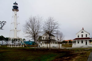
Cape San Blas
latitude 29° 48' 47.6" N longitude 85° 18' 23.4" W
February 13, 2018 access: car
In 2014, the light and the keepers houses were moved from their original location to downtown Port St. Joe. When you arrive in town in State Route 98, turn south on 4th avenue and you can't miss it. ARLHS # USA-136 |
|
| FL 29 |
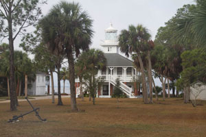
| Old St. Joseph Bay
latitude 29° 44' 54.9" N longitude 85° 18' 15.6" W
February 13, 2018 access: car
South of Port Saint Joe where Highway 98 makes a 90 degree turn, turn south on County Road 30 and continue for 2.2 miles where you will see the lighthouse on your right. The lighthouse is a private residence, but the owners permit pictures from the street. ARLHS # USA-1285 |
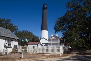
| FL 30 |
Pensacola
latitude 30° 20' 45.8" N longitude 87° 18' 29.6" W
February 13, 2018 access: car
From Highway 90 in Pensacola, turn south on Highway 295 (New Warrington Road and Navy Boulevard), and follow it for three miles, and then turn right on SR 292 (Barrancas Avenue). SR 295 leads to the main gate of the Pensacola Naval Air Station, but visitors must now use a different entrance. Continue on SR 292 for 5.2 miles, and then turn left on SR 173, which will lead you to the air station. (J 3394) ARLHS # USA-592 |
|
|
|
If you would like copies of any of my pictures, contact me and we'll discuss arrangements. Thereare others who do this commercially, I have no intention of competing directly, but you can make a proposal, and I'll react. mailMe
 Gulf Coast States
 South Atlantic States