|
This page shows the documentation about the Lighthouses of the Bahamas. In addition, the pictures below are linked to the relevant photo on the web (thus making available to you a higher resolution picture.) I am very grateful to Russ Rowlett at the University of North Carolina for his excellent Lighthouse Directory from which I built the outline. Each lighthouse is linked to (in our editorial opinion) the best reference site for that light. LHdirectory |
|
Great Abaco
| BA 1 |
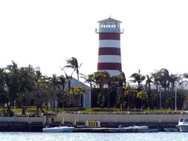
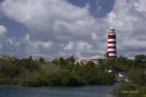
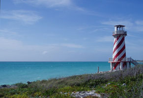
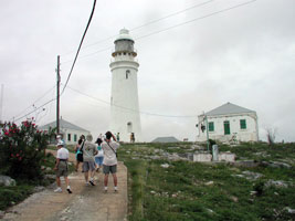
Elbow Cay (Hope Town)
Located on Elbow Cay on the west side of the harbor at Hope Town. Island accessible by ferry from Marsh Harbour, Great Abaco Island ((242) 367-3147). (J 4572) ARLHS # BAH-010
Photo courtesy JustASunGod [Flickr] |
|
| BA 2 |
Little Harbour |
Located at the entrance to Little Harbour, about 25 km south of Marsh Harbour, Great Abaco Island. Accessible by a short walk to the end of the peninsula sheltering the harbor. ARLHS # BAH-021 |
| BA 3 |
Abaco (Hole-in-the-Wall)
Located at the southern tip of Great Abaco Island. Accessible by boat or over a rugged road by 4WD vehicles. (J 4580) ARLHS # BAH-004
Photo courtesy BahamaGal23 [webshots] |
|
Grand Bahama
| BA 4 |
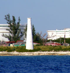
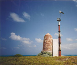
| Pinder's Point
The historic lighthouse at Pinder's Point on Grand Bahama no longer has a light, and even worse, it no longer has red and white stripes. It is dwarfed by the oil storage tanks behind it, not to mention the much taller chimneys, which, to add insult to injury, do have red and white stripes near the top. Located on a prominent cape on the southwestern coast of the island. (J 4594) ARLHS # BAH-024
Photo courtesy Andrew Conway [Flickr] |
| BA 6 |
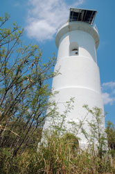
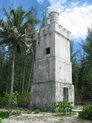
| High Rock
Built by the Rev Cecil Kemp across the road from his Lighthouse Chapel. Rev. Kemp says it serves as a guiding light for seamen and lost and drifting souls.
Photo courtesy Andrew Conway [Flickr] |
Bimini
| BA 7 |
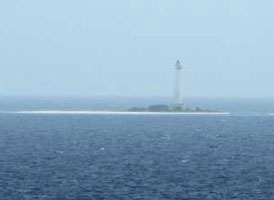
Great Isaac
A familiar landmark for cruise ship passengers en route to Nassau from Florida.Located on Great Isaac Cay at the north end of the Bimini archipelago. Accessible only by boat. ARLHS # BAH-002
Photo courtesy Joy Kidd [Flickr] |
|
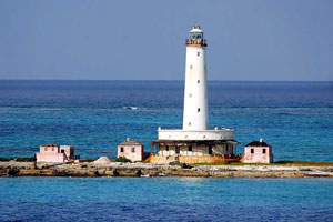
| BA 8 |
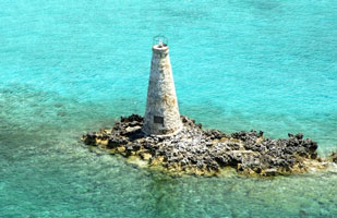
| Gun Cay
Located at the south end of the cay, in the Bimini group. ARLHS # BAH-009
Photo courtesy © 2006 KW Baker [Flickr] |
| BA 9 |
North Cat Cay Breakwater |
The lighthouse is now owned by the Cat Cay Club. The island is just south of Gun Cay in the Bimini Group. Located at the end of the north breakwater. club ARLHS # BAH-023 |
|
|
Berry & Andros Islands
| BA 10 |
Great Stirrup Cay
Located at the northern end of the Berry Islands. The cay is a regular stop for Norwegian Cruise Lines ships. ARLHS # BAH-008
Photo courtesy Jen [Flickr] |
|
| BA 11 |
Whale Point (Whale Cay)
latitude 25° 23' 42" N longitude 77° 48' 1.5" W |
Located on Little Whale Cay at the extreme southern end of the Berry Islands. The island is a privately owned resort. cay ARLHS # BAH-022 |
| BA 12 |
Andros
Located in Coakley Town (Fresh Creek) north of Andros Town on the east side of the island. ARLHS # BAH-017
Photo courtesy Dale J [Flickr] |
|
Nassau
| BA 13 |
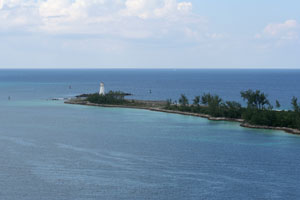
| Paradise Island (Hog Island, Nassau Harbour)
latitude 25° 5' 12.9" N longitude 77° 21' 5.4" W
This is the oldest lighthouse in the Bahamas and probably the oldest in the West Indies. Located at the western end of Paradise Island (formerly Hog Island) marking the northwest entrance to Nassau Harbor. (J 4655) ARLHS # BAH-014
Photo courtesy T. Hall [Flickr] |
| BA 14 |
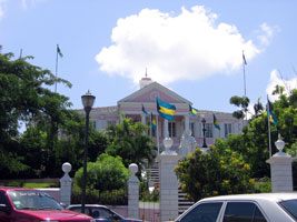
Government House
Light displayed from the cupola of Government House in downtown Nassau. ARLHS # BAH-019
Photo courtesy Tesla [Flickr] |
|
Islands
| BA 15 |
Egg Island |
Located at the highest point of the island off the northwestern tip of Eleuthera. ARLHS # BAH-006 |
| BA 16 |
North Palmetto Point |
Located 4 miles south of Governor's Harbor on the easternmost point of Eleuthera Island. ARLHS # BAH-013 |
| BA 17 |
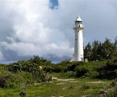
Eleuthera Point (Lighthouse Point)
latitude 24° 37' 13.8" N longitude 76° 8' 31.2" W |
Older light lists show the station originally had two lights on skeletal towers. Located atop a bluff on Lighthouse Point, at the southern tip of Eleuthera |
|
|
| BA 18 |
Little Pipe Cay
Located on a reef of Little Pipe Cay, about 12 km northwest of Staniel Cay in the Exumas. Accessible only by boat.
Photo courtesy marinas.com [marinas.com] |
|
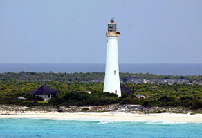
| BA 19 |
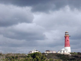
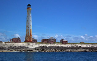
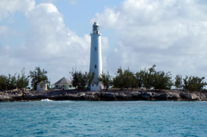
| San Salvador (Dixon Hill)
latitude 24° 5' 51.7" N longitude 74° 27' 5.4" W
The lighthouse is fueled by kerosene and refueled, by hand, every 2 hours and 15 minutes. Located on the highest point of the island of San Salvador, on the northeastern side of the island. ARLHS # BAH-015
Photo courtesy Kyle Crider [Flickr] |
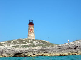
| BA 20 |
Bird Rock
latitude 22° 50' 43" N longitude 74° 21' 35.6" W
Four vacation suites in the light station are available for rental. Located on a small island off the northwestern tip of Crooked Island in the southern Bahamas. (J 4792) ARLHS # BAH-005
Photo courtesy Captain Theo [ListOfLights] |
|
| BA 21 |
Booby Rock (Great Harbor) |
ARLHS # BAH-016 |
| BA 22 |
Castle Island (Acklins Island)
latitude 22° 7' 34.9" N longitude 74° 19' 42.3" W
Located on a small island off the southwest tip of Acklins Island. (J 4782) ARLHS # BAH-001
Photo courtesy Captain Theo [ListOfLights] |
|
Southern Channels
| BA 23 |
| Cay Sal
Located on Elbow Cay, at the western end of the Cay Sal Bank about 80 km off the Cuban coast and 130 km southeast of Key West. Accessible only by boat. ARLHS # BAH-018
Photo courtesy Cliff and Ally [Flickr] |
| BA 24 |
Cay Lobos
Located on a tiny but very dangerous cay in the Old Bahama Channel only 50 km from Cuba. (J 4774) ARLHS # BAH-011
Photo courtesy mumz [webshots] |
|
| BA 25 |
| Hogsty Reef
Located on Northwest Cay, the largest island of the reef, which is halfway between Acklin's Island and Great Inagua Island ARLHS # BAH-020
Photo courtesy Capt. Eric T. Wiberg, 1995 [uboats] |
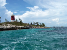
| BA 26 |
Great Inagua (Southwest Point)
Located at Matthew Town on Great Inagua Island, at the southern end of the Bahamas archipeligo. courtesy Karl & Cat ARLHS # BAH-007
Photo courtesy Anonymous [Flickr] |
|
| BA 27 |
| Grand Turk
Located at the northern tip of Grand Turk Island (which is technically not part of the Bahamas); accessible by road. Cruise ships calling at the island offer tours that include the light station.
Photo courtesy geoshar [webshots] |
|
|
 Florida