|
This page shows the lights in the Southern Atlantic States (North and South Carolina and Georgia). The pictures below are active, if you press on one, you'll be directly connected to the site with that picture (or one very similar) at a much higher resolution Index data is from the List of ALL Existing U.S. Lighthouses by Bob and Sandra Shanklin p2 For the directions, we are in debt to Lighthouse Friends w4 |
|
| NC 1 |
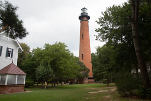
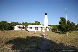
Currituck Beach
latitude 36° 22' 35.9" N longitude 75° 49' 51.4" W
September 16, 2013
Built in 1873, the walls at the bottom are 5' thick and at the top they are still 3' thick. People coming down from the tower kept saying "214 steps up and 214 steps down". Since the line was long, we chose to look around and leave.
Take highway 158 onto the barrier islands and then 20 miles north on route 12. Be prepared for slow traffic and much of it. Turn left where it says "lighthouse". (J 2384) ARLHS # USA-212 |
|
| NC 2 |
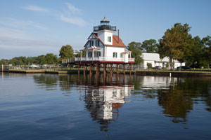
| Roanoke River
latitude 36° 3' 21.9" N longitude 76° 36' 40" W
September 20, 2013
This light was moved from its original site. It's been moved again, now it's on the waterfront in Edenton. The closest address is 113 Water street. Follow Broad Street to its end at the River. ARLHS # USA-694 |
| NC 2a |
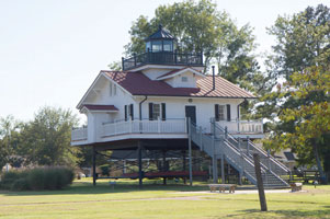
Roanoke River (replica)
latitude 35° 51' 58.7" N longitude 76° 45' 14.6" W
September 19, 2013
From Hwy 64 in Plymouth, turn N on Washington St and continue until the T at Water St. Turn L onto Water street and the light will be on the R. |
|
| NC 2b |
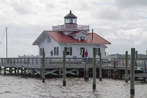
| Roanoke Marshes (replica)
latitude 35° 54' 29.4" N longitude 75° 40' 5.7" W
September 17, 2013
From Nags Head, take Hwy 64 W over Roanoke Sound and turn R into Manteo. After 1.6 miles, turn R on Agona St and follow (a fairly twisted route) to its end. |
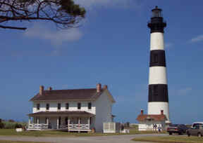
| NC 3 |
Bodie Island
latitude 35° 49' 7" N longitude 75° 33' 48.6" W
September 17, 2013
The first light was built here in 1848, but within a year it settled 1' more on one side than the other, so they took it down and rebuilt it on good foundations. Unfortunately, in 1862 the light was destroyed by retreating confederate soldiers. The existing tower was built in 1872 and is 166' tall. With a first-order Fresnel lens, the light from an oil lamp could be seen 18 miles away.
Take highway 158 onto the barrier islands and proceed south (on 158, not on the beach road). (J 2386) ARLHS # USA-067 |
|
| NC 4 |
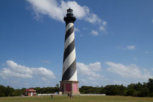
| Cape Hatteras
latitude 35° 15' 1.7" N longitude 75° 31' 43.9" W
September 17, 2013
From Hwy 12, just E of Buxton, turn S to reach the Hatteras Island Visitors Center. (J 2396) ARLHS # USA-119 |
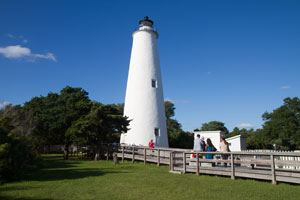
| NC 5 |
Ocracoke Island
latitude 35° 6' 32.3" N longitude 75° 59' 9.7" W
September 17, 2013
Ocracoke Island can be reached by a ferry from Cape Hatteras or a longer ferry from either Cedar Island or Swan Quarter. On the island, take Hwy 12 into the village and turn S on Lighthouse Rd. (J 2408) ARLHS # USA-561 |
|
| NC 6 |
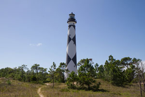
| Cape Lookout
latitude 34° 37' 22.2" N longitude 76° 31' 28.2" W
September 18, 2013
Authorized ferry service is available from Harkers Island, Beaufort, Davis and Morehead City. The landing at Harkers Island is the closest. (J 2430) ARLHS # USA-126 |
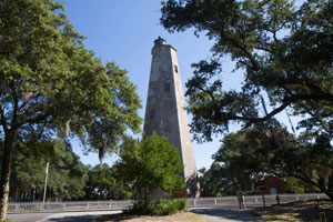
| NC 7 |
Bald Head
latitude 33° 52' 24.7" N longitude 78° 1.6" W
September 19, 2013
A 20 minute ferry ride from Southport. Once on the island, it's an easy walk. Website
The Ferry is not easy to find. When you reach the corporate limits of Southport, take an immediate left. At the end of the road, another left is necessary. From there, it was relatively easy to find. ARLHS # USA-032 |
|
|
|
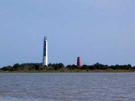
| NC 8 |
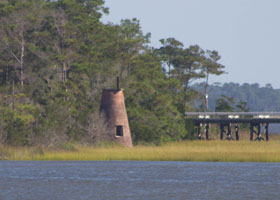
| Prices Creek
latitude 33° 56' 10" N longitude 77° 59' 23" W
September 19, 2013
A distant view can be had from the Ferries leaving the Southport landing. You must actually take the ferry to see the lighthouse. We took this picture from the Bald Head ferry with my 300 mm lens. (Port side, off the back of the boat just as we left the channel.) ARLHS # USA-672 |
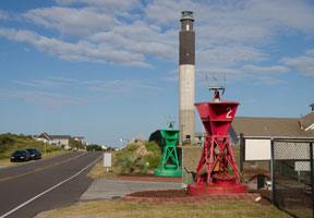
| NC 9 |
Oak Island
latitude 33° 53' 34.4" N longitude 78° 2' 6" W
September 19, 2013
From downtown Wilmington, take Hwy 74 W over the Cape Fear River, then turn S on Hwy 133 for 27 miles to Oak Island. When the highway ends, turn left on Caswell Beach Rd and continue E for 2.5 miles. (J 2470) |
|
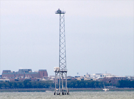
| NC 10 |
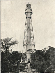
| Cape Fear
latitude 33° 50' 47.9" N longitude 77° 57' 57.2" W
Yes Virginia, there was a Cape Fear lighthouse. It was a Steel external skeleton structure, but not tall enough to be effective. It was taken out of service in 1958 and demolished in 2010.
Photo courtesy DigitalNC.org [Wikipedia] |
| SC 1 |
Georgetown
latitude 33° 13' 21.6" N longitude 79° 11' 6.3" W
Captain George Gallager offers Cape Romain Lighthouse Tours and will take you to Georgetown Lighthouse as well. Captain Benjamin Floyd ((843) 670-3123) also provides transportation to view the lighthouses. gallager (J 2582) ARLHS # USA-323
Photo courtesy TTVo [Flickr] |
|
| SC 2 |
| Cape Romain
latitude 33° 1' 8.6" N longitude 79° 22' 25.4" W
see above ARLHS # USA-134
Photo courtesy pegduke [webshots] |
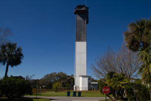
| SC 3 |
The Charleston Light (Sullivan's Island)
latitude 32° 45' 28" N longitude 79° 50' 35.2" W
March 22, 2019 access: car
From Highway 17 on the east side of Charleston Harbor, take the Highway 17 business route to Highway 703. Follow Highway 703 onto Sullivan's Island. Where Highway 703 turns left, continue straight to Lion Avenue. Turn right onto Lion Avenue (J 2646) ARLHS # USA-825 |
|
| SC 3F |
| Charleston Front Range
latitude 32° 45' 28" N longitude 79° 50' 35.2" W
March 21, 2019 access: boat
Charleston Harbor has now gone very modern. The path into the harbor is illuminated with a pair of lights arranged in a range pattern (one over the other when you are in the channel.) |
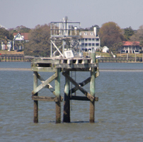
| SC 3R |
Charleston Rear Range
latitude 32° 45' 28" N longitude 79° 50' 35.2" W
March 20, 2019 access: boat
The rear range is only a search light focused towards the sea mounted on a light steel stand. |
|
|
|
| SC 4 |
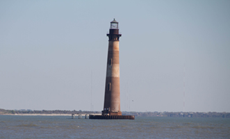
| Old Charleston Light (Morris Island)
latitude 32° 41' 43" N longitude 79° 53' 1.1" W
March 22, 2019
From Charleston, take Highway 171 south to Folly Island and the town of Folly Beach. In Folly Beach, turn left at the second traffic signal onto Ashley Street, and follow it to the road barricade. After parking your vehicle, you can continue on foot about 0.5 miles to the tip of the island.
Morris Island lighthouse stands all alone about 300 yards off shore from the island of Folly Beach. It can be viewed from the northeast end of Folly Island and from the bridge coming on to the island. Folly Beach ARLHS # USA-515 |
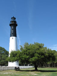
| SC 5 |
Hunting Island
From Beaufort, travel 16 miles east on Highway 21 to Hunting Island State Park. Once on the island, take the second entrance to your left where you will need to pay an entrance fee. hunting island (J 2744.5) ARLHS # USA-392
Photo courtesy Linda Montgomery [Flickr] |
|
| SC 6 |
Old Hilton Head |
Take Highway 278 onto Hilton Head Island. Near mile marker 8 is Palmetto Dunes Resort where the light is located. From 278, turn east onto Queens Folly Road until you come to a guard shack. Tell them you want to visit the lighthouse, and they will give you a pass. Proceed straight on Ocean Lane, until you see a gate on your right for Arthur Hills Golf Course. Go through the gate, and then turn left onto Leamington Lane. ARLHS # USA-971 |
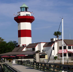
| SC 7 |
Harbour Town (privately built, 1970)
latitude 32° 8' 19.3" N longitude 80° 48' 45.2" W
March 25, 2019
Take Highway 278 to Hilton Head Island. Once on the Island, take the Cross Island Parkway until you arrive at the traffic circle and then turn onto Greenwood Drive. Greenwood Drive will become Plantation Drive. Follow Plantation Drive to Lighthouse Road and then turn right on Lighthouse Road ARLHS # USA-1135
Photo courtesy Karl Eschenbach [Flickr] |
|
| SC 8 |
| Haig Point Rear Range (Daufuskie Island)
latitude 32° 8' 42.4" N longitude 80° 50' 11.8" W
March 25, 19 access: boat
tour (many available) ARLHS # USA-216 |
| SC 9 |
Bloody Point Front Range
latitude 32° 5' 49.8" N longitude 80° 52' 23.4" W |
It can be seen from Daufuskie Island Resort's Bloody Point Golf Course, and an obstructed view is possible from a nearby road. resort ARLHS # USA-1003 |
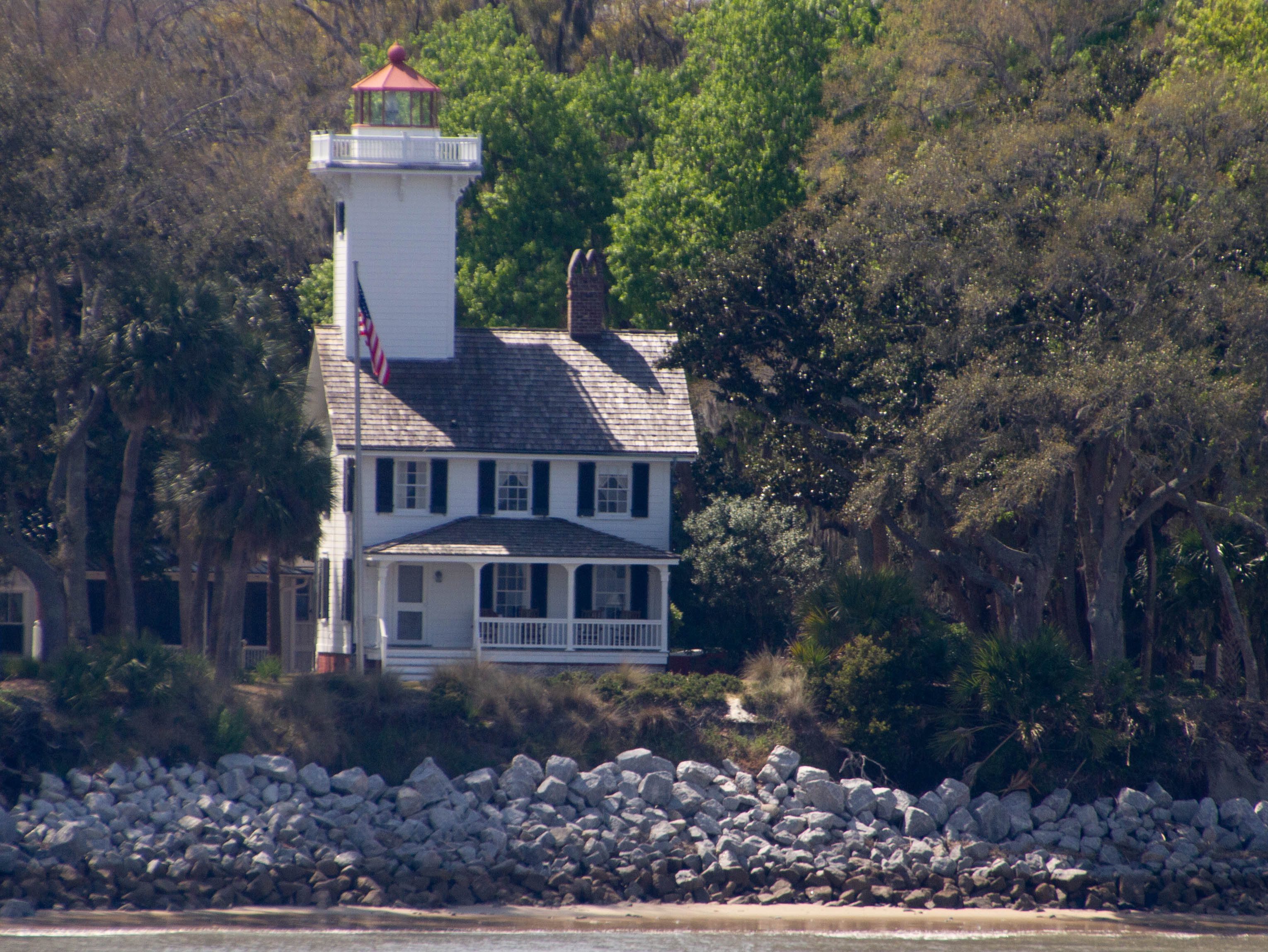
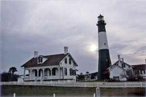
| GA 1 |
Tybee Island
latitude 32° 1' 19.9" N longitude 80° 50' 44.2" W
March 26, 2019
From I 516 in Savannah, take Hwy 80 E for 19 miles to the island. At the 1st stop light, turn L onto Campbell Ave. When it ends, take a L onto Van Horn St and then a R onto Meddin Dr. (J 2776.1) ARLHS # USA-864
Photo courtesy Gordon and Pat Roush |
|
| GA 2 |
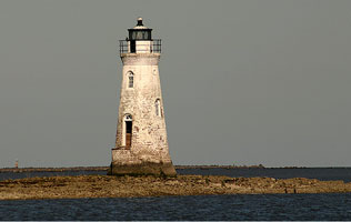
| Cockspur Beacon
latitude 32° 1' 21.3" N longitude 80° 52' 48.1" W
March 26, 2019
Cockspur Beacon is only accessible by boat. When the tide comes in, it goes all the way up to the door. The land that you see is covered with oysters and is an active oyster bed.
From I 516 in Savannah, take Hwy 80 E for 15.5 miles to the Fort Pulaski National Monument. You can proceed over the bridge to the light, or you can continue S on 80 just past Lazaretto Creek where you can drive to the river and get a closer view. (J 2803.4) ARLHS # USA-181
Photo courtesy Rachel Pennington [Flickr] |
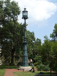
| GA 2a |
Savannah Harbor
latitude 32° 4' 45.5" N longitude 81° 5' 3.4" W
March 26, 2019
Follow Savannah's cobbled River St E along the river. As you make the U-turn at the end, and climb up to East Bay St, the Old Harbor Light will be on your right in Emmett Park. ARLHS # USA-1387
Photo courtesy KudzuVine [wikipedia] |
|
| GA 3 |
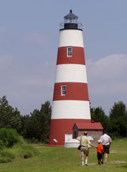
| Sapelo Island
Tours of the island (4 hours) are offered on Saturdays at 9AM (add in 30 minutes for the ferry). The ferry dock is 8 miles N of Darien. From I 95, take exit 11 and follow Hwy 99 9.3 miles to Landing Road. Turn L. ARLHS # USA-738
Photo courtesy phodge [webshots] |
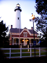
| GA 4 |
St. Simon's Island
latitude 31° 8' 2.7" N longitude 81° 23' 36.7" W
March 28, 2019
From Hwy 17 in Brunswick, take Torras Causeway to the island. After the bridge over the Frederica river, turn R on King's Way. Past the blinking signal at the Causeway and past the traffic signal at Frederica, at the next traffic light, turn R on Mallory St, go one block and turn L on Beachview. Go 1/4 mile to 12th st and turn R. (J 2842) ARLHS # USA-805
Photo courtesy lee-3dHighway [Flickr] |
|
|
|
 Virginia
