|
This page currently shows what I know about Mississippi through Texas. (Not much.) Directions are courtesy of Lighthouse Friends LHfriends Index data (numbers on the left edge) are from the List of ALL Existing U.S. Lighthouses by Bob and Sandra Shanklin p2 |
|
| AL 1 |
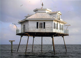
Middle Bay
access: boat
Captain Jim Hall offers trips to the lighthouse. *
Photo courtesy Sarah Chadwick [Flickr] |
|
| AL 2 |
| Mobile Point
latitude 30° 13' 40.1" N longitude 88° 1' 27.3" W
access: ferry
Fort Morgan can be reached from the western side of Mobile Bay by taking a ferry from Dauphin Island. Call (334) 540-7787 for information on the Mobile Bay Ferry. From the eastern side of Mobile Bay, take Highway 180 west to its end.
Photo courtesy lburly [webshots] |
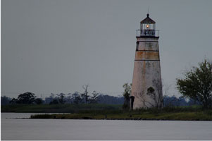
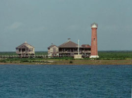
| MS 3 |
Ship Island |
rebuilt in 2000, destroyed again by Katrina in 2005
Ship Island Excursions offers ferry service from Gulfport, Mississippi to Ship Island, where the lighthouse and replica formerly stood. Ferry service is available March through October, weather permitting. The ferry dock is located on the Mississippi Sound side of the island near Fort Massachusetts. The site of the lighthouse can be reached by walking 0.3 miles east along the beach from the dock. Tours of the fort are offered by the park service, and a boardwalk leads 1/3 of a mile across the island to the Gulf, where a swimming beach is located. * |
| MS 1 |
Round Island
latitude 30° 17' 31" N longitude 88° 35' 11.6" W |
destroyed by Hurricane Georges, 1998.
In late 2009, the City of Pascagoula, Mississippi received permission from the Mississippi Department of Archives and History to move the base of Round Island Lighthouse from Round Island to the mainland where it will be restored in the city's downtown district near the US 90 high-rise bridge over the Pascagoula River. |
| MS 1C |
Biloxi Casino Marina (faux)
latitude 30° 23' 29.4" N longitude 88° 53' 37.4" W
access: car
You can see this light from the parking lot on the ocean side of the Biloxi light below. |
|
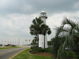
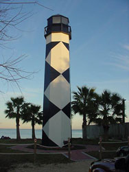
| MS 2 |
| Biloxi
latitude 30° 23' 39.6" N longitude 88° 54' 4.1" W
March 27, 2007 access: car
We took this picture during a visit to God's Katrina Kitchen. You can see a pre-Katrina photo below.
From Interstate 10 north of Biloxi, take exit 46 to Interstate 110. Travel south on Interstate 110 for just over four miles to Highway 90. Go west on Highway 90, and you will see the lighthouse in the median in less than a half mile. (J 3578) |
| MS 2p |
Biloxi pre Katrina (pre Katrina)
access: none
Note that in this picture (pre-Katrina), most of the trees that surrounded the light are no longer there. Relit Feb 19, 2010.
Photo courtesy luv2run [Flickr] |
|
| MS 2B |
| Broadwave Beach Marina
latitude 30° 23' 18.4" N longitude 88° 57' 50.1" W
access: car
This probably was just a day mark for the entrance to the Marina. Since the marina is no longer operational, whether there originally was a light here is no longer clear.
This light is only a few miles west of the Biloxi light above. |
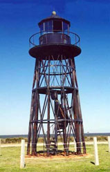
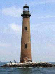
| AL 3 |
Sand Island
access: boat
Captain Jim Hall offers trips to the lighthouse. #
Directions: The light is visible from Fort Morgan on Mobile Point, but the best views come from the water. *
Photo courtesy lburly [webshots] |
|
|
|
| LA 3 |
Tchefuncte River |
Located along the northern shore of Lake Pontchartrain, near the mouth of the Tchefuncte River, south of Madisonville. |
| LA 4 |
Pass Manchac |
Located in Lake Ponchartrain, just offshore from where Pass Manchac leads west into Lake Maurepas. |
| LA 5 |
New Canal
access: none
destroyed by Hurricane Katrina & following storms 2005
Flickr. An even more gorgeous picture was taken by David SM (from the other side).
Photo courtesy 2004 photoDonna McCraw [Flickr] |
|
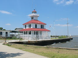
| LA 6 |
| Port Ponchartrain
access: car
From New Orleans, take Interstate 10 East to Interstate 610 East (left exit). Continue on Interstate 610 East until the Elysian Fields Avenue exit. Turn left onto Elysian Fields. Continue north for about three miles to the traffic circle. Take the 2nd exit and you will see the lighthouse on your right between the two buildings as you U-turn left. You must check in with the guard at the gate.
Photo courtesy Coka Koehler [Flickr] |
| LA 7 |
Pass A' L'Outre |
Located in the Mississipi River Delta near the junction of North Pass and Pass a Loutre. This area is part of the Pass A Loutre Wildlife Management Area. park |
| LA 9 |
South Pass |
Located in the Mississipi River Delta near the mouth of South Pass. This area is part of thePass A Loutre Wildlife Management Area. park |
|
|
| LA 10 |
SouthWest Pass (1838) |
Today, three of the lighthouses that have served Southwest Pass remain standing. Ships can readily see the evolution of lighthouse construction as they pass the stub of a brick tower, an iron skeleton tower, and a modern Texas-tower all found near the entrance to Southwest Pass. |
| LA 12 |
SouthWest Pass (Modern) |
In 1929, a light and fog signal were established at the end of the east jetty, which was constructed at the entrance to the pass. The jetty light was upgraded to serve as the primary entrance light in 1953. It performed this function until 1965, when the modern tower was placed in the waters just off the jetties. This substantial structure was in service until the fall of 2007 when it was demolished and replaced by a skeletal tower perched atop a platform supported by three steel piles. |
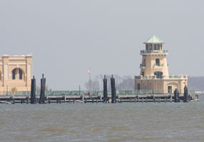
| LA 13 |
Ship Shoal |
After winding its way south through America’s heartland, the Mississippi River separates into many channels before reaching the Gulf of Mexico. Today, the primary shipping channel is Southwest Pass. Marking the entrance to this pass is the most modern major light on the gulf, which consists of a six-sided, two-story building, with a smaller but similarly shaped tower projecting upward from its center. This superstructure, along with a boat dock and a helicopter landing pad, rests on a lattice of concrete pilings anchored in the floor of the gulf. |
| LA 14 |
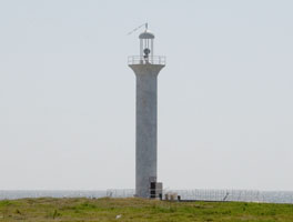
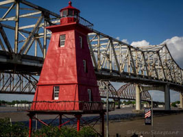
SouthWest Reef
latitude 29° 41' 39.4" N longitude 91° 12' 58.7" W
access: car
From Highway 90 in Berwick near the west end of the bridge over Berwick Bay, exit and proceed east to the water. The lighthouse will be at the water's edge south of the Highway 90 bridge.
Photo courtesy Karen Seargent [Facebook] |
|
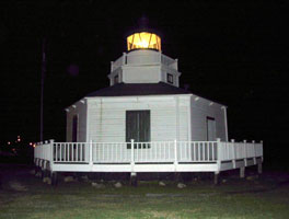
| LA 15 |
| Sabine Pass
access: car
This light is located in the Sabine State Park. State Park
Directions: Roughly one mile east of the Sabine River, Lighthouse Road leads south for roughly four miles from Highway 82 to the lighthouse. The road is only accessible in dry conditions. To view the lighthouse from across Sabine Pass, take Highway 87 south from Port Arthur to the town of Sabine Pass. When the highway makes a right in town, continue straight on Dowling Road, which will take you to Sabine Pass Battleground State Park directions
Photo courtesy ccquesenberry [webshots] |
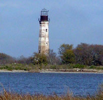
| TX 1 |
Sabine Bank
latitude 29° 44' 5.3" N longitude 93° 53' 38.1" W |
Directions: To visit the Sabine Bank lighthouse in its original location, one can charter a boat in Port Arthur to take you across Sabine Lake, down the Sabine River passing the Sabine Pass lighthouse, and then out to the lighthouse. The top of the lighthouse can be see at Lions Park in Sabine Pass located at the intersection of Lincoln and Jackson. * |
| TX 2 |
Bolivar Point
access: car ferry
The lighthouse can be reached by taking the ferry from Galveston across the mouth of Galveston Bay or by taking Highway 87 from Port Arthur to Port Bolivar. The lighthouse is on the northern side of Highway 87 a mile or so from the ferry landing. ferry
Photo courtesy Crystal Beach [CrystalBeach] |
|
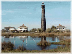
| TX 3 |
Galveston Jetty
latitude 29° 19' 40.3" N longitude 94° 41' 33.9" W |
Take Highway 87 to the eastern end of Galveston and continue on Seawall Boulevard. After roughly a mile, take a right on East Beach Drive and follow it to the large parking lot at the beach. The jetty is located at the eastern end of the parking lot.
A violent storm struck the lighthouse on May 2, 2000, and the iron pilings, weakened by years of rust, gave way toppling the lighthouse into the water. |
| TX 3A |
Kemah Lighthouse
access: car
Taken in Kemah, Texas on Galveston Bay.
Photo courtesy ccquesenberry [webshots] |
|
| TX 4 |
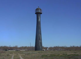
| Matagorda
latitude 28° 20' 16.4" N longitude 96° 25' 26.6" W
access: boat
Port Oconner Port
Directions: Ferry service to the island used to be available, but the ferry burned and has not been replaced. Some local captains, like Captain Bob Hill, offer transportation to the island. A distant view of the lighthouse is possible from Port O'Connor. directions
Photo courtesy jraycjj [webshots] |
| TX 5 |
Half Moon Reef
latitude 28° 38' 12.8" N longitude 96° 37' 2.2" W
access: car
Take Highway 35 to Port Lavaca. The lighthouse is located alongside Highway 35 near the west end of the causeway over Lavaca Bay.
Photo courtesy jraycjj [webshots] |
|
| TX 6 |
| Aransas Pass (Lydia Ann)
latitude 27° 51' 51" N longitude 97° 3' 23.3" W
access: car, then view
The lighthouse can be seen in the distance by looking up the intracoastal waterway from Port Aransas. One good place in particular is Lighthouse Trails, a kayaking launch site next to Highway 361 between Aransas Pass and the ferry to Port Aransas. (J 4216.49)
Photo courtesy J. Prentice [Flickr] |
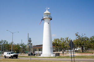
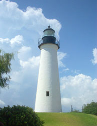
| TX 7 |
Port Isabel
latitude 26° 4' 39.9" N longitude 97° 12' 27.1" W
access: car
Take Highway 100 into Port Isabel. The lighthouse is located alongside Highway 100 just before the causeway leading to South Padre Island.
Photo courtesy Larry Weiss [Flickr] |
|
|
|
If you have a picture where I have none, I'm interested in putting it here. You maintain copyright and I'll publish that and how to contact you (if you like). If you would like copies of any of my pictures, contact me and we can discuss arrangements. There are others who do this commercially, I have no intention of competing directly, but you can make a proposal, and Ill react. mailMe


