|
This page shows the Lighthouses of the New Jersey. Reference numbers are from the Shanklin's list p2 Downloadable copies of this pictures are stored on the web (typically Flickr). The pictures below are active, if you press on one, you'll be directly connected to the site with that picture (or one very similar) at a much higher resolution. For the directions, we are in debt to Lighthouse Friends LF |
|
| NJ 1 |
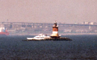
Robbins Reef
latitude 40° 39' 26.6" N longitude 74° 3' 56.2" W
The lighthouse can be seen for free from the Staten Island Ferry. The ferry departs form the Whitehall Terminal at Whitehall Street and South Street in Lower Manhattan and from the St. George Ferry Terminal at Richmond Terrace on Staten Island. (J 1156) ARLHS # USA-695
Photo courtesy Tom Anderson [Flickr] |
|
| NJ 2 |
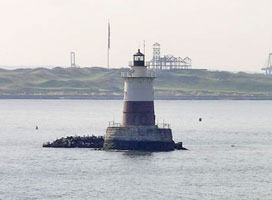
| Great Beds
latitude 40° 29' 12.1" N longitude 74° 15' 10.8" W
October 21, 2014
A good viewing point on land is from below the grounds of the Conference House.
Located at the end of Hylan Boulevard (cross street Satterly) on the southwestern tip of Staten Island. (J 1058) ARLHS # USA-344 |
| NJ 4 |
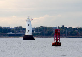
| Conover Beacon (Chapel Hill Front Range)
latitude 40° 25' 17" N longitude 74° 3' 20.2" W
October 21, 2014
From Highway 36 in Leonardo, exit onto Leonard Avenue and go north about eight blocks to the shoreline. ARLHS # USA-191 |
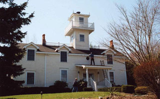
| NJ 5 |
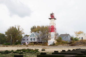
Chapel Hill
latitude 40° 23' 53.7" N longitude 74° 3' 31.5" W
The light is now a private residence and located at the end of a long driveway making it very difficult to see. Please respect the owner's privacy.
We were unable to find this light (October 2014). Other data on location should be searched.
ARLHS # USA-153
Photo courtesy manytoes [Webshots] |
|
| NJ 6 |
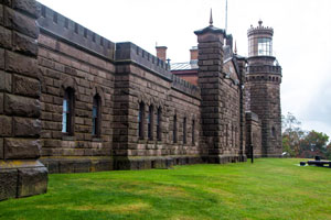
| Navesink
latitude 40° 23' 47.4" N longitude 73° 59' 8.9" W
October 21, 2014
From Highway 36 in Highlands, take the first exit on the west side of (or last exit if traveling south before) Highlands Bridge, and go south on Portland Road for just a very short distance before turning right onto Highland Drive. After passing the condominiums on your left, turn left onto Lighthouse Road and follow it up the steep hill to the parking lot ARLHS # USA-530 |
|
|
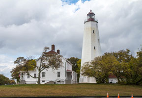
| NJ 7 |
Sandy Hook
latitude 40° 27' 41.9" N longitude 74° 7.2" W
October 21, 2014
From Highway 36 near Highlands, travel to the east side of the Highlands Bridge and then go north to enter the Gateway National Recreation Area. The lighthouses is five miles up the hook from Highway 36. At the north end of Sandy Hook, you enter Fort Hancock Historic District. Take the Magruder road to the right of the sign to the Fort Hancock Parking Lot and the Sandy Hook Lighthouse. (J 1036) ARLHS # USA-731 |
|
| NJ 8 |
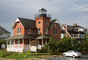
| Sea Girt
latitude 40° 8' 11.8" N longitude 74° 1' 38.8" W
October 21, 2014
From Highway 71 in Sea Girt, take Beacon Boulevard east to Ocean Avenue. Follow route 36/Joline Ave to the intersection of route 35 and follow it south. Sea Girt ave is 12 miles, turn left there. ARLHS # USA-744 |
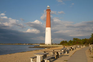
| NJ 9 |
Barnegat
latitude 39° 45' 51.6" N longitude 74° 6' 22.3" W
October 21, 2014
From the Garden State Expressway, take exit 63 and travel east on Highway 72 seven miles to Long Beach Island. When Highway 72 ends, turn left onto Long Beach Boulevard and drive 8.5 miles to Barnegat Lighthouse State Park at the northern end of the island. njParks (J 1223) ARLHS # USA 039 |
|
| NJ 9T |
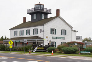
| Tucker's Island (replica)
latitude 39° 36' 7" N longitude 74° 20' 33.5" W
October 22, 2014
Eight years after the original lighthouse was lost, the Coast Guard station was claimed by the sea. The entire island had disappeared by 1952. In the 1980s, a group of southern Ocean County sportsmen expressed concern that the old ways of bay life were in danger of extinction. This group’s vision led to the eventual creation of Tuckerton Seaport. One of the many buildings at the seaport is a re-creation of Tucker’s Island Lighthouse. Located some six miles west of its original location, the lighthouse should be quite safe from the sea. details ARLHS # USA-911 |
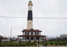
| NJ 10 |
Absecon
latitude 39° 21' 58.8" N longitude 74° 24' 50.8" W
October 22, 2014
From the Garden State Parkway, take Exit 38 and go east on the Atlantic City Expressway 7.5 miles to Atlantic City. Once in Atlantic City, turn left on Pacific Avenue and follow it for 1.3 miles to Rhode Island Avenue. ARLHS # USA 001 |
|
|
|
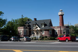
| NJ 11 |
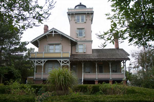
| Hereford Inlet
latitude 39° 21.9" N longitude 74° 47' 26.3" W
October 22, 2014
From the Garden State Parkway, take Exit 6 and follow Highway 147 (North Wildwood Boulevard) southeast 3.9 miles. The main road will become Spruce Avenue and then New Jersey Avenue along the way. In Wildwood, turn left onto Chestnut and drive two blocks to the light. (J 1244) ARLHS # USA-370 |
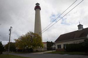
| NJ 12 |
Cape May
latitude 38° 55' 58.6" N longitude 74° 57' 37.3" W
October 22, 2014
Take the Garden State Parkway to its southern terminus, and proceed west on Highway 109 North to Route 9. Turn left on Seashore Road, which will take you over the intracoastal waterway. Seashore Road will become Broadway, and from Broadway you need to turn right onto Sunset Boulevard. After about 1.7 miles, turn left on Lighthouse Avenue, and the entrance to the park will be on your left. (J 1256) ARLHS # USA-127 |
|
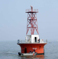
| NJ 13 |
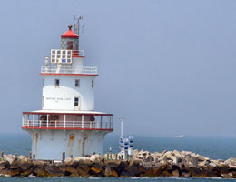
| Brandywine Shoal
Cape May Whale Watcher and Delaware Bay Lighthouse Keepers & Friends both offer cruises during the summer that pass by the Brandywine Shoal Lighthouse. (J 1264) ARLHS # USA-076
Photo courtesy Diane Ham [Flickr] |
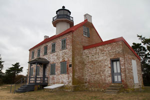
| NJ 14 |
East Point
latitude 39° 11' 45.6" N longitude 75° 1' 38.4" W
October 22, 2014
From Highway 47 just east of Delmot, take Glade Road (Highway 616) west towards Heislerville. Near Heislerville Glade Road will become East Point Road. Follow East Point Road to its end at the mouth of the Maurice River. ARLHS # USA-262 |
|
| NJ 15 |
| Miah Maull Shoal
Cape May Whale Watcher and Delaware Bay Lighthouse Keepers & Friends both offer cruises during the summer that pass by the Miah Maull Shoal Lighthouse. (J 1268) ARLHS # USA-492
Photo courtesy Diane Ham [Flickr] |
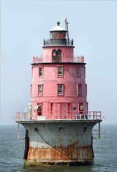
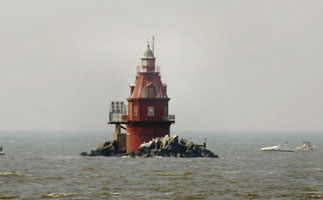
| NJ 16 |
Cross Ledge
The remains of this lighthouse are best seen from the water. Cape May Whale Watcher and Delaware Bay Lighthouse Keepers & Friends both offer cruises during the summer that pass by the Cross Ledge Lighthouse. ARLHS # USA-931
Photo courtesy djbjr243 [Webshots] |
|
| NJ 17 |
| Ship John Shoal
latitude 39° 18' 18.8" N longitude 75° 22' 35.8" W
Cape May Whale Watcher and Delaware Bay Lighthouse Keepers & Friends both offer cruises during the summer that pass by the Ship John Shoal Lighthouse ARLHS # USA-758
Photo courtesy Diane Ham [Flickr] |
| NJ 18 |
Finns Point Rear Range (Fort Mott)
latitude 39° 37' 1.6" N longitude 75° 32' 2" W
May 5, 2010
From Highway 49 south of Pennsville, take Fort Mott Road south for 1.7 miles to Lighthouse Road. (J 1315.9) ARLHS # USA 285 |
|
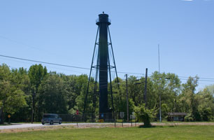
| NJ 19 |
| Tinicum Rear Range
latitude 39° 50' 51" N longitude 75° 14' 23.1" W
July 15, 2008
This light actually serviced 2 front ranges. Tinicum front range was 5/8 mile southwest. The other is Billingsport front light. Neither still exists.
From Interstate 295 near Paulsboro, take Exit 18 and travel north on Delaware Street. Your first right should be Commerce Street. Follow Commerce Street to Broad Street, where you will need to jog right to remain on Commerce Street. Commerce Street will become Mantau Avenue, which will lead to Billingsport. Continue on Commerce Street to 3rd Street. (J 1315.9) ARLHS # USA-852 |
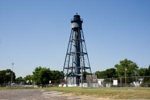
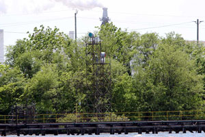
| NJ 20 |
Tinicum Front Range
latitude 39° 50' 52.2" N longitude 75° 15' 9.9" W
Delaware River (J 1315.8)
Photo courtesy Mike Boucher [ListOfLights] |
|
| PA 4 |
| Turtle Rock (PA)
latitude 39° 58' 11.9" N longitude 75° 11' 23.4" W
May 5, 2005
This light is on the Schuylkill River, Fairmount Park, below the rowing marina. It's the last boathouse on Philadelphia's Boathouse Row. (note: the other Pennsylvania lights are listed under Lake Erie.) Erie |
|
|