|
This page shows the lights in Virginia. The pictures below are active, if you press on one, you'll be directly connected to the site with that picture (or one very similar) at a much higher resolution. Copies of my pictures are stored on the Webshots site if you want to download them. webshots For the directions, we are in debt to Lighthouse Friends w4 Index data is from the List of ALL Existing U.S. Lighthouses by Bob and Sandra Shanklin p2 |
|
| VA 1 |
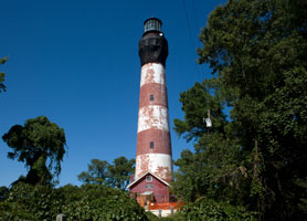
Assateague
latitude 37° 54' 40.6" N longitude 75° 21' 22.1" W
August 24, 2008 access: car
From rte 13 on the eastern shore (4 miles S of MD line), take route 175 east to Chincoteague. Turn left on Main St and the R on Maddox blvd. The trail will be on your right about a half mile inside the National Wildlife Refuge. ARLHS # USA-021 |
|
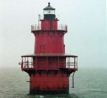
| VA 2 |
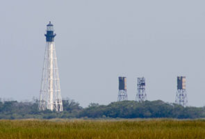
| Cape Charles
latitude 37° 7' 23" N longitude 75° 54' 23.3" W
September 16, 2013 access: car or boat
Best viewed from the water (on the west side of the Southern Section of Smith Island (just N of the entrance to Chesapeake Bay). You can take a boat out of Kiptopeke State Park. This is the second highest VA light.
From the ground, take the Chesapeake bridge/tunnel North, turn right on first road after the welcome center, turn left on Seaside road, the right again on Dixon drive. It's about 2 miles of dirt lane out to a dock from which you can get very nice pictures. ARLHS # USA-109 |
| VA 3 |
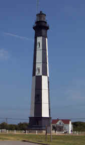
New Cape Henry
latitude 36° 55' 34.8" N longitude 76° 26.1" W
June 26, 2002 access: car
Located in Virginia Beach, this light is inside Fort Story (an active army base). The light was built in 1872 and was replaced with the light below in 19xx.
Take Shore Road (highway 60) towards the point. When it turns south, ignore the first turn into the base and go to the light where you can turn left. Some very nice people will check you out, then send you 1 mile into the base where the lights are. ARLHS # USA-121 |
|
| VA 4 |
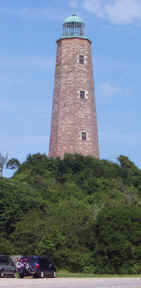
| Old Cape Henry
latitude 36° 55' 32.8" N longitude 76° 29.6" W
June 26, 2002 access: car
It looks like there are tours of this light available. ARLHS # USA-122 |
|
|
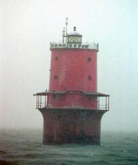
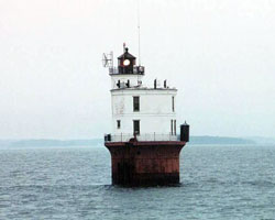
| VA 5 |
Thimble Shoals
latitude 37° 52.2" N longitude 76° 14' 25.4" W
access: boat
Best seen from a boat, but can be seen at a distance from Fort Monroe. ARLHS # USA-842
Photo courtesy lightlady35 [webshots] |
|
| VA 6 |
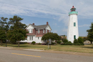
| Point Comfort , Old
latitude 37° 6.3" N longitude 76° 18' 23.1" W
September 16, 2013 access: car
From I 64, take exit 268 (just north of the Hampton River), drive NE on Mallory Street. Turn R for .7 miles to Ingalls Rd. Turn R at the second light one to E Mellen St and proceed for .6 miles entering Fort Monroe. Turn left before the old hotel and follow the road to the first battlement. ARLHS # USA-567 |
|
|
| VA 7 |
Newport News Middle Ground
latitude 36° 56' 42.6" N longitude 76° 23' 29.2" W
access: boat
Visible from I 664 as you cross the James River from Portsmouth to Newport News or from King-Lincoln Park near the northern end of the bridge.
Photo courtesy lightlady35 [webshots] |
|
| VA 8 |
| Point Comfort , New
latitude 37° 18' 3.7" N longitude 76° 16' 40.1" W
access: boat
From I 64, take exit 220 and go E on Route 33 for 19 miles to Route 198 in Glenns. Turn R and follow for 22 miles to Route 14. Follow Route 14 8 milles to Bavon. Turn left (still Route 14) there. Follow Route 600 to its end to the preserve. Horn Harbor Marina (Captain Monty Biggs) offers charters to this light. ARLHS # USA-543
Photo courtesy duggavt [webshots] |
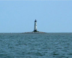
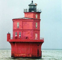
| VA 9 |
Wolf Trap
access: boat
Captain Monty Biggs of Horn Harbor Marina offers charters ARLHS # USA-903
Photo courtesy lightlady35 [webshots] |
|
| VA 10 |
| Smith Point
access: boat
Look for Cruises offered by the Chesapeake Chapter of the US Lighthouse Society. ARLHS # USA-764
Photo courtesy lightlady35 [webshots] |
| VA 11 |
Jones Point
latitude 38° 47' 25.4" N longitude 77° 2' 26.2" W
June 23, 2002 access: car
Located in Alexandria, this light is right on Jones Point. Unfortunately, that is almost directly under Interstate 95 where it crosses the Potomac south of Washington, thus very hard to get to.
Take highway 1 south in Alexandria, turn left on Green Street, right on Royal Street, then follow the signs to Jones Point. ARLHS # USA-409 |
|
|
|
If you would like copies of any of my pictures, contact me and we will discuss arrangements. There are others who do this commercially, I have no intention of competing directly, but you can make a proposal, and I'll react. mailme
 Maryland
