|
This page shows the Lighthouses of the Maryland. The pictures below are active, if you press on one, you'll be directly connected to the site with that picture (or one very similar) at a much higher resolution. Downloadable copies of this pictures are stored on the web (mostly Webshots or Flickr). For the directions, we are in debt to Lighthouse Friends. w4 Reference numbers are from the Shanklin's list p2 |
|
| MD 1 |
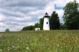
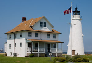
Turkey Point
latitude 39° 26' 59.5" N longitude 76° 30.1" W
access: car + walk (1 mile)
From Interstate 95, take Exit 100 and travel south on Highway 272. After 2.4 miles you will cross Highway 7. Continue on Highway 272 for 11 more miles (Highway 272 will become Turkey Point Road) and enter Elk Neck State Park. At the end of the road, park and follow the trail for about a mile to the lighthouse. ARLHS # USA-857
Photo courtesy Thom Perry [Flickr] |
|
| MD 2 |
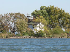
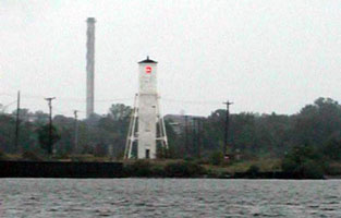
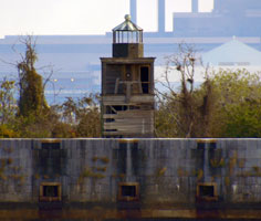
| Fishing Battery
access: boat
One way to get here is a lighthouse cruise from Havre de Grace aboard the skipjack Martha Lewis. Martha ARLHS # USA-287
Photo courtesy brownerw [webshots] |
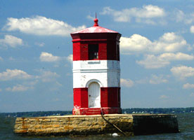
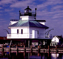
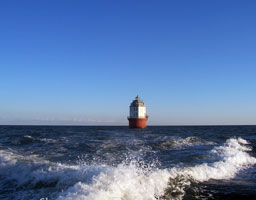
| MD 3 |
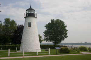
Concord Point (Havre de Grace)
latitude 39° 32' 26.2" N longitude 76° 5' 5.1" W
July 28, 2006 access: car
Built in 1827, its the 2nd oldest tower on Chesapeake bay, and is in the town of Havre de Grace. Thus probably with a similar purpose as Seul Choix way up in Michigan, a light to bring you comfortably home again. It marks the end of 444 miles of the Susquehanna River and the beginning of the Chesapeake Bay. MI 42 ARLHS # USA-186 |
|
| MD 4 |
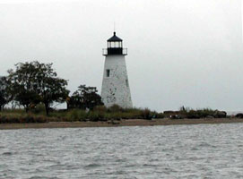
| Pooles Island
latitude 39° 17' 33.7" N longitude 76° 15' 39.6" W
access: boat
One can visit the lighthouse with Down Time Sportfishing Charters. downTime ARLHS # USA-646
Photo courtesy djbjr [webshots] |
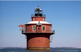
| MD 5 |
Craighill Channel Upper Range Rear
latitude 39° 12' 57.7" N longitude 76° 27' 45.5" W
access: car
Located on Wharf Road on the west side of Old Road Bay in Sparrows Point, on property owned by a steel mill ARLHS # USA-201
Photo courtesy djbjr [webshots] |
|
| MD 6 |
| Craighill Channel Upper Range Front
latitude 39° 11' 49.6" N longitude 76° 26' 53.9" W
access: boat
Accessible only by boat, but there are excellent views from the former Fort Howard VA Medical Center (soon to be a retirement community called Bayside at Fort Howard). ARLHS # USA-200
Photo courtesy Thom Perry [Flickr] |
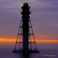
| MD 7 |
Craighill Channel Lower Range Front
latitude 39° 11' 19" N longitude 76° 23' 40" W
access: boat
Located in the harbor entrance about 2 miles east southeast of North Point. Accessible only by boat. There's a distant view from North Point State Park. north point ARLHS # USA-198
Photo courtesy J. Wayne Higgs [Flickr] |
|
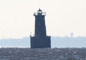
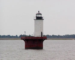
| MD 8 |
| Craighill Channel Lower Range Rear (MillersIsland)
latitude 39° 13' 44.5" N longitude 76° 23' 39.7" W
access: boat
The tallest Maryland lighthouse, this unusual light doesn't get the attention it deserves. Located in the Chesapeake Bay just east of Ramona Beach about 3 miles northeast of Fort Howard. ARLHS # USA-199
Photo courtesy Thom Perry [Flickr] |
| MD 9 |
Fort Carroll
latitude 39° 12' 52.7" N longitude 76° 31' 8.4" W
access: car + long lens
A distant view is possible from Fort Armistead Park on the western bank of the Patapsco River near the Interstate 695 bridge. To reach the park, take exit 1 from Interstate 695 and drive south on Quarantine Road to Hawkins Point Road. Go east on Hawkins Point Road to Fort Armistead Road, which will take you to the park. ARLHS # USA-290
Photo courtesy Thom Perry [Flickr] |
|
|
|
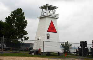
| MD 10 |
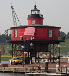
| Seven Foot Knoll
latitude 39° 17' 3.8" N longitude 76° 36' 25.2" W
July 28, 2006 access: car
Physically located in the heart of Baltimore's Harbor (now), we looped around this light trying to navigate city streets. Found a downtown parking lot, pulled in, took these pictures, then were told that the meter showed no time, so it was free (instead of $4 for the first 1/2 hour). ARLHS # USA-750 |
| MD 11 |
Baltimore
latitude 39° 3' 33.1" N longitude 76° 23' 56.4" W
access: boat
It can be seen from Gibson Island or Beacon Hill. Watermark Cruises out of Annapolis offers a Lighthouse Cruise that passes this lighthouse. cruise ARLHS # USA-034
Photo courtesy pwhsu48 [webshots] |
|
| MD 12 |
| Sandy Point Shoal
January 11, 2007 access: car + long lens
Good views can be had from Sandy Point State Park. To reach the park, take exit 32 from Highway 50, the exit at the western end of the Chesapeake Bay Bridge, and drive north into Sandy Point Park. ARLHS # USA-733 |
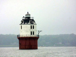
| MD 13 |
Hooper Strait
latitude 38° 47' 16.8" N longitude 76° 13' 8.4" W
access: car
At the Chesapeake Bay Maritime Museum in St. Michaels. ARLHS # USA-378
Photo courtesy Thom Perry [Flickr] |
|
| MD 14 |
| Bloody Point Bar
January 11, 2007 access: car + long lens
You can get close enough on shore to at least get a view and maybe a picture if you have a good lens for your camera; it is only 0.9 miles off shore. Going east on US Route 50 from Annapolis, cross the Chesapeake Bay Bridge and exit at Maryland State Route 8, exit 37, the first exit after the bridge, and go south onto Kent Point Road. Continue on Kent Point Road for 7.1 miles until State Route 8 bears off to the left onto Romancoke Road but you need to bear right on Kent Point Road. You do need to walk through a private driveway to get this picture. ARLHS # USA-063 |
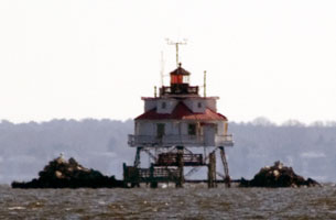
| MD 15 |
Thomas Point Shoal
latitude 38° 53' 55.3" N longitude 76° 26' 9.9" W
January 11, 2007 access: car + long lens
The lighthouse is visible from Thomas Point Park. To reach the park, take exit 22 from Route 50 just east of Annapolis. Go south on Route 665, also know as Aris T Allen Boulevard, which will become Forest Drive. Continue for about 2.8 miles, then turn right onto Arundel On the Bay Road. Follow it south to Thomas Point Road. It's about a 1 mile walk from the door into the park (which is "no vehicles w/o permit") to the point where I took this picture. ARLHS # USA-845 |
|
| MD 16 |
| Sharps Island
access: boat
One can take a trip aboard Miss Kim with Captain Wade Murphy from Dogwood Harbor on Tilghman Island. skip jack ARLHS # USA-751
Photo courtesy pwhsu48 [webshots] |
|
|
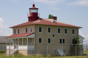
| MD 17 |
Cove Point
latitude 38° 23' 11.1" N longitude 76° 22' 54.3" W
July 26, 2006 access: car
Built in 1828, it was built to mark a shoal that often caught ships. It wasn't until 1857 that a Fresnel lens was installed and in 1926 a modern electric lamp replaced the oil lamp. It was automated in 1986 and now is owned by the Calvert Marine Museum (the owners of Drum Point below as well) ARLHS # USA-195 |
|
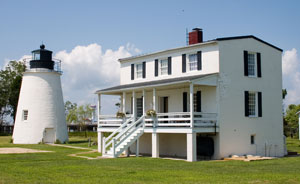
| MD 18 |
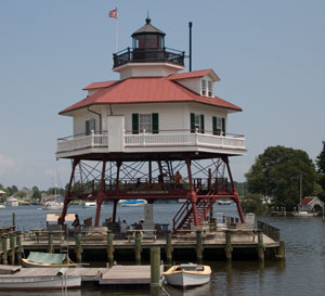
| Drum Point
latitude 38° 19' 52.5" N longitude 76° 27' 47.9" W
July 26, 2006 access: car
This was a classic light built on top of piles literally screwed into the bottom. However, it no longer is in place, but can be seen at the museum in Solomons (that's correct, it's plural) MD. So now it's attached to the top of wooden piles. ARLHS # USA-235 |
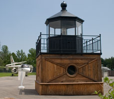
| MD 19 |
Cedar River
July 26, 2006 access: car
The lighthouse is demolished at this point. The top of the light house is preserved in the Patuxent River Air Museum. ARLHS # USA-1020 |
|
| MD 20 |
| Hooper Island
latitude 38° 15' 23" N longitude 76° 15' W
access: boat
Located on the eastern side of the Chesapeake Bay, 3.75 miles west of the town of Hoopersville on Middle Hooper Island. ARLHS # USA-377
Photo courtesy mmperkey [webshots] |
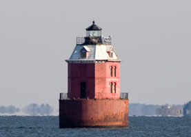
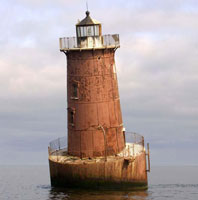
| MD 21 |
Point No Point
access: boat
Located on the western side of the Chesapeake Bay, 6.3 miles north of Point Lookout and the northern side of the entrance to the Potomac River. ARLHS # USA-630
Photo courtesy Robert Scott Henry (from a fishing expedition with Robert Charles Henry) |
|
| MD 22 |
| Solomons Lump
latitude 38° 2' 53.5" N longitude 76° 54" W
access: boat
Located in the Kedges Straits, which connect Tangier Sound and the Chesapeake Bay. ARLHS # USA-767
Photo courtesy mmperkey [webshots] |
| MD 23 |
Point Lookout
latitude 38° 2' 19.2" N longitude 76° 19' 20" W
July 26, 2006 access: car
Located where the Potomac river flows into the Bay, this light was originally built in 1830 and rebuilt as a two story structures in 1883. More details are available if you click here ARLHS # USA-628 |
|
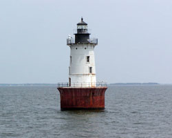
| MD 24 |
| Piney Point
latitude 38° 8' 6.8" N longitude 76° 31' 46.8" W
July 26, 2006 access: car
Built in 1836, this light is 14 miles up river from Point Lookout (see above) and is the oldest light on the Potomac River. ARLHS # USA-601 |
| MD 24A |
Ragged Point
latitude 38° 9' 15.8" N longitude 76° 36' 5" W |
ARLHS # USA-685 |
| MD 24B |
Cobb Point Bar (Cobb Island Bar)
latitude 38° 14' 32.6" N longitude 76° 49' 33.6" W |
Located off Cobb Island at the western entrance to the Wicomico River; visible from many points on the south side of Cobb Island (end of MD 254). ARLHS # USA-989 |
| MD 24C |
Lower Cedar Point
latitude 38° 20' 24" N longitude 76° 59' 34.8" W |
Located in the middle of the river between Lower Cedar Point MD and Dahlgren VA. Visible from Cedar Beach on the Maryland side and from the Harry Nice Bridge (US 301) over the river. ARLHS # USA-458 |
| MD 24D |
Mathias Point Shoal
latitude 38° 24' 17.3" N longitude 77° 2' 34.8" W |
It appears that protective rip rap barriers have been placed to the east and west of the light. Located off the Virginia shore at Matthias Point north of Dahlgren. Visible from the Mt. Bethel Recreation Center, near the end of secondary route 624 at Matthias Point VA. ARLHS # USA-483 |
| MD 24E |
Upper Cedar Point |
Located off the Maryland shore about 2 miles west of Matthias Point. Accessible only by boat. ARLHS # USA-867 |
| MD 24F |
Maryland Point
latitude 38° 20' 58.2" N longitude 77° 11' 51" W |
Located in the middle of the river between Wellington Beach MD and Fairview Beach VA; visible from Wellington Beach off MD 224. ARLHS # USA-1311 |
| MD 25 |
Fort Washington
latitude 38° 42' 44.1" N longitude 77° 2' 12.8" W
July 25, 2006 access: car
Located just down the Potomac from Jones Point. This light was initially just a post upon which a light could be hoisted. It's now a radar post for the defense of the capital. VA 11
Cross the Woodrow Wilson Bridge on the South Beltway and exit on Rout 210. Go South to Fort Washington Road and enter the National Park ARLHS # USA-302 |
|
|
|
If you would like copies of any of my pictures, contact me and we can discuss arrangements. There are others who do this commercially, I have no intention of competing directly, but you can make a proposal, and I will react. mailme
 Delaware
