|
This page shows the Lighthouses of Delaware. Downloadable copies of this pictures are stored on the web (mostly Webshots or Flickr). The pictures below are active, if you press on one, you'll be directly connected to the site with that picture (or one very similar) at a much higher resolution. For the directions, we are in debt to Lighthouse Friends w4 Reference numbers are from the Shanklin's list p2 |
|
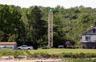
| DL 1F |
Marcus Hook Front Range
latitude 39° 46' 32.8" N longitude 75° 28' 30.9" W
July 15, 2008 access: boat
This range guides vessels downstream. The front range is located in the Delaware River opposite the foot of Hilltop Road in Bellefonte; there's a good view from the north end of nearby Fox Point State Park. This photo was taken across I-495. Fox Pt (J 1314) |
|
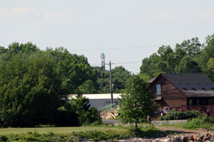
| DL 1R |
| Marcus Hook Rear Range
latitude 39° 45' 44" N longitude 75° 30' 10.9" W
July 15, 2008 access: car
This range guides vessels downstream. Located 1.75 mi southwest of the front light on Lighthouse Road just south of Lore Avenue in Bellefonte. (J 1314.1) ARLHS # USA-474 |
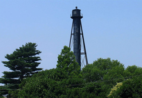
| DL 2 |
Bellevue Rear Range
July 15, 2008 access: boat
Accessed through Wilmington's Cherry Island Landfill, which does permit admittance for birdwatchers and lighthouse enthusiasts. However, for next couple of years, construction prevents access. The landfill can easily be reached by taking I-495 Exit 3, just north of the Christiana River, and going southeast on 12th Street. This photo was take from I-495 (J 1313.1) ARLHS # USA-050 |
|
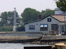
| DL 2C |
| Cherry Island Range
latitude 39° 45' 43.4" N longitude 75° 29' 23.2" W
July 15, 2008 access: car
From Interstate 495, take Exit 4 and proceed to Governor Printz Boulevard, also known as Highway 13, which parallels Interstate 495 on its northern side. Turn right onto Governor Printz Boulevard. After ½ mile, turn left onto Lore Avenue and the turn right onto River Road after 0.4 miles. From River Road, turn right after 0.3 miles onto Riverside Drive. Turn right into a parking lot after Riverside Drive turns left, at the end of which you will find the Cherry Island Rear Range Light. (J 1309.1) ARLHS # USA-165 |
| DL 2F |
New Castle Front Range
latitude 39° 38' 32.3" N longitude 75° 35' 42.7" W
access: car
Located on the Delaware River bank at the east end of Grantham Road about 2 mi southwest of New Castle and 800 yards from the rear range. (J 1301) ARLHS # USA-546
Photo courtesy Alex Trabas [ListOfLights] |
|
|
|
| DL 2R |
| New Castle Rear Range
latitude 39° 38' 53.5" N longitude 75° 35' 56.5" W
access: car
Located just west of DE 9 on Granham Lane, about 2 mi southwest of New Castle. (J 1301.1) ARLHS # USA-547
Photo courtesy Alex Trabas [ListOfLights] |
| DL 3 |
Liston Front Range
access: car
From Port Penn, travel south on Route 9 for 2.3 miles crossing over Augustine Creek. At this point the road will make a sharp right turn, and there will be a road on your left leading into a private community at Bay View Beach. The residents of the community are not too cordial to visitors, so your best bet is to settle for a view of the lighthouse from Route 9. (J 1292) ARLHS # USA-436
Photo courtesy Luiz Castro [Flickr] |
|
| DL 4 |
| Liston Rear Range
latitude 39° 31' 25.5" N longitude 75° 38' 22.6" W
access: car
From Highway 13 at Biddle's Corner (1.8 miles south of the Chesapeake and Delaware Canal), turn east onto County Road 2 (Port Penn Road). The lighthouse will be on your left after about a half mile, across the road from the Hickory Grove Cemetery. (J 1292.1) ARLHS # USA-437
Photo courtesy Luiz Castro [Flickr] |
|
|
| DL 5 |
Reedy Island Rear Range
latitude 39° 24' 23.9" N longitude 75° 35' 25.3" W
access: car
From Highway 13 in the town of Fieldsboro, go east on Fieldsboro Road for 1.6 miles to Highway 9 (Taylor's Bridge Road). Turn right on Highway 9 and drive three miles to Taylor's Bridge, where you will see the light alongside the road. (J 1299.1) ARLHS # USA-692
Photo courtesy ka3unq [webshots] |
|
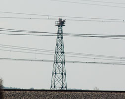
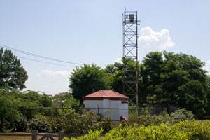
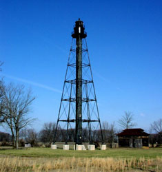
| DL 6 |
Mispillion River
latitude 38° 56' 50.6" N longitude 75° 18' 54" W |
From Highway 1 north of Lewes, go east on Highway 36. Highway 36 is a loop over to Slaughter Beach, so there are two exits for it from Highway 1. You can take either exit. Northeast of Slaughter Beach, take Lighthouse Road from Highway 36 and follow it to its end where you can view the iron tower that replaced the lighthouse. ARLHS # USA-503 |
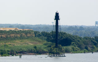
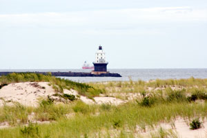
| DL 7 |
Fourteen Foot Bank
access: boat
Cape May Whale Watcher and Delaware Bay Lighthouse Keepers & Friends both offer cruises during the summer that pass by the Fourteen Foot Bank Lighthouse. ARLHS # USA-305
Photo courtesy Diane Ham [Flickr] |
|
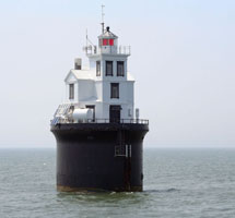
| DL 8 |
| Delaware Breakwater East
latitude 38° 47' 49.8" N longitude 75° 5' 59.8" W
August 28, 2008 access: car + long lens
This light can be viewed from Cape Henlopen State Park Henlopen
To reach the park, take Highway 9 north through Lewes and then continue past the ferry terminal and into the park. The best place from which to view the lighthouse is in the northeastern end of the park. ARLHS # USA-223 |
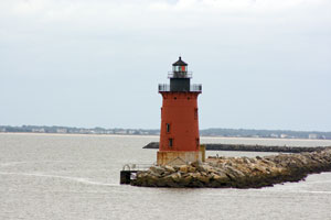
| DL 9 |
Harbor of Refuge
latitude 38° 48' 51.1" N longitude 75° 5' 34.1" W
August 28, 2008 access: car
Follow signs for the Cape May - Lewes ferry but stay on the same road. That road will end at the Henlopen State Park (J 1280) ARLHS # USA-366 |
|
| DL 9L |
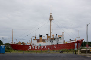
| Overfalls Lightship
latitude 38° 46' 40.6" N longitude 75° 8' 28.1" W
August 28, 2008 access: car
The Lightship Overfalls (LV118) is one of only 17 remaining lightships out of a total of 179 built from 1820 to 1952. Placed on the National Register of Historic Places in 1988, it is one of seven lightships in this country still open to the public.
Located in Lewes, Delaware. |
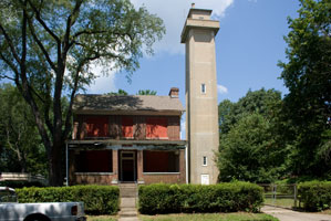
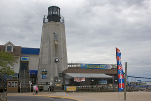
| DL 9R |
Rehoboth Lighthouse Restaurant
latitude 38° 41' 22.2" N longitude 75° 4' 33.3" W
August 28, 2008 access: car
Probably a faux light, but neat anyway. |
|
| DL 10 |
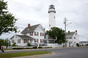
| Fenwick Island
latitude 38° 27' 4.8" N longitude 75° 3' 17.9" W
August 28, 2008 access: car
At the state line where Delaware Route 1 (Ocean Highway) becomes Maryland Route 528 (Coastal Highway), turn west on 146th Street. (Coming from the south, you turn left on Lighthouse road, then loop around to 146th Street.) (J 1354) ARLHS # USA-283 |
|
|
If you would like copies of any of my pictures, contact me and we'll discuss arrangements. There are others who do this commercially, I have no intention of competing directly, but you can make a proposal, and I'll react. mailme
 NewJersey
