|
This page the documentation about the Lighthouses of the Bermuda. In addition, the pictures below are linked to the relevant photo on the web (thus making available to you a higher resolution picture.) Each lighthouse is linked to (in our editorial opinion) the best reference site for that light. |
|
| BE 1 |
Gibbs Hill
latitude 32° 15' 9.9" N longitude 64° 50' 4.3" W |
Located on the highest point of the island in Southampton Parish, southwest of Hamilton. photo ARLHS # BER-010 |
| BE 2 |
Perot's Island (Southwest Head) |
The island is privately owned and probably best seen from the Gibb's Hill lighthouse. ARLHS # BER-007 |
| BE 3 |
Rickett's Island (Hamilton Harbour) |
ARLHS # BER-008 |
| BE 4 |
Lefroy
latitude 32° 17' 1.3" N longitude 64° 48' 57.8" W |
ARLHS # BER-005 |
| BE 5 |
Hinson Island, Timlins Narrows |
The channel was opened before 1841, but no reference to a light is mentioned. ARLHS # BER-012 |
|
|
| BE 6 |
Chub Heads
latitude 32° 17' 10.6" N longitude 64° 58' 47.4" W |
Located on a reef at the extreme western end of the Bermuda archipelago. photo ARLHS # BER-017 |
| BE 7 |
Mark Rock |
ARLHS # BER-006 |
| BE 8 |
Two Rocks Passage |
ARLHS # BER-016 |
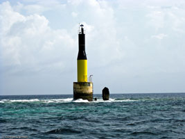
| BE 9 |
Hogfish
latitude 32° 18' 38.3" N longitude 64° 49' 21" W |
This beacon marks the northwest end of a dangerous reef a short distance east of Bermuda's main entrance channel. Located in Great Sound about 3 mi north of Gibb's Hill Light. ARLHS # BER-013 |
|
|
| BE 10 |
Gibbet Islet |
The island is named for the hanging posts that were there. It is visible from shore, but the light may not be. ARLHS # BER-001 |
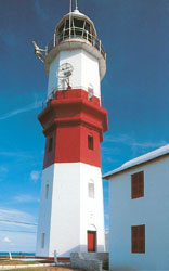
| BE 11 |
St. David's
latitude 32° 21' 50.5" N longitude 64° 39' 6.4" W
Located on a hilltop on St. David's Island, in St. George Parish, near the northeastern tip of the islands. photo (J 4472) ARLHS # BER-009
Photo courtesy Prime Products - Bermuda [ListOfLights] |
|
| BE 12 |
| Hen Island (J 4481) ARLHS # BER-003
Photo courtesy Captain Peter Mosselberger [ListOfLights] |
| BE 13 |
Higg's Island /Town Cut Channel (J 4476) ARLHS # BER-004
Photo courtesy Captain Peter Mosselberger [ListOfLights] |
|
| BE 14 |
Eastern Blue Cut
latitude 32° 23' 50" N longitude 64° 52' 36.8" W |
Located on a reef on the northwestern side of the Bermuda archipelago. Accessible only by boat. photo ARLHS # BER-011 |
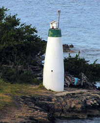
| BE 15 |
Kitchen Shoal |
ARLHS # BER-014 |
| BE 16 |
North Rock
latitude 32° 28' 31.1" N longitude 64° 46' 9.8" W
Located on an isolated limestone reef at the northernmost point of the Bermuda archipelago, about 16 km northwest of St. David's Light. Accessible only by boat. ARLHS # BER-015
Photo courtesy Cliff Vachon [panoramio] |
|
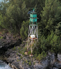
| BE 17 |
North East Breaker |
Located at the extreme northeastern tip of the Bermuda reef system, 8 mi north northeast of St. David's Light. photo ARLHS # BER-018 |
| BE 18 |
Gun Point |
ARLHS # BER-002 |
|
|
 Florida