|
This page currently shows the documentation about the Lighthouses of Eastern Mexico. In addition, the pictures below are linked to the relevant photo on the web (thus making available to you a higher resolution picture.) I am very grateful to Russ Rowlett at the University of North Carolina for his excellent Lighthouse Directory from which I built the outline. Each lighthouse is linked to (in our editorial opinion) the best reference site for that light. LHdirectory |
|
Tamaulipas
| MX 1 |
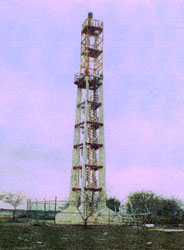
Río Bravo
Located in Matamoros on the south side of the entrance to the Rio Grande, which is called the Rio Bravo del Norte in Mexico. ARLHS # MEX-037
Photo courtesy Alejandro Lopez Ceja [skyscrapercity] |
|
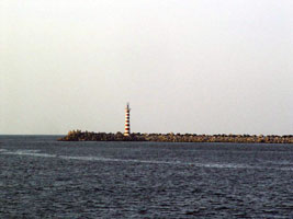
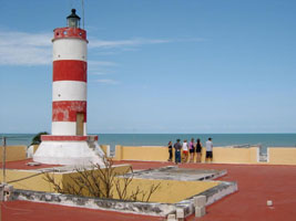
| MX 3 |
Canal de Chavez
This lighthouse marks an artificial channel cut through the barrier beach. Located on the beach 70 km south of the Río Bravo. ARLHS # MEX-177
Photo courtesy Alejandro Lopez Ceja [skyscrapercity] |
|
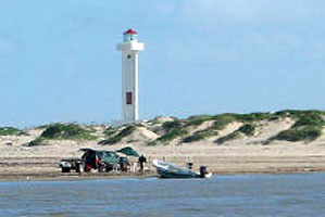
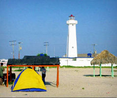
| MX 5 |
La Pesca
The lighthouse marks the southern entrance to the Laguna Madre. Accessible by road. ARLHS # MEX-034
Photo courtesy Alejandro Lopez Ceja [skyscrapercity] |
|
| MX 6 |
Punta Jerez |
Punta Jerez, about 70 km north of Tampico, is not a cape but only a subtle bend in the barrier beach. This remote location is best reached by boat ARLHS # MEX-058 |
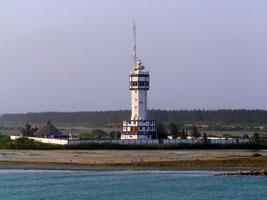
| MX 7 |
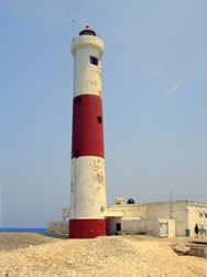
Altamira Tampico
latitude 22° 29' 33.9" N longitude 97° 51' 47" W
Altamira is a new port constructed on the north side of the Tampico metropolitan area. Located on the north side of the harbor entrance. (J 4233) ARLHS # MEX-097
Photo courtesy Peter Mosselberger [ListOfLights] |
|
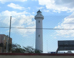
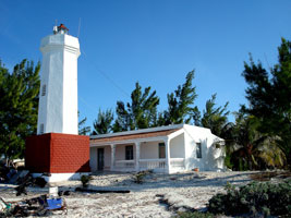
| MX 8 |
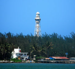
| Tampico (Madero)
latitude 22° 15' 44.2" N longitude 97° 47' 39.2" W
The lighthouse was designed by U.S. engineers and prefabricated in Pittsburgh. It is the only surviving example of its design. Located in an industrial area on the north side of the entrance to the Río Pánuco, about ¾ mi from the open Gulf of Mexico ARLHS # MEX-033
Photo courtesy Terry Westerman |
Veracruz
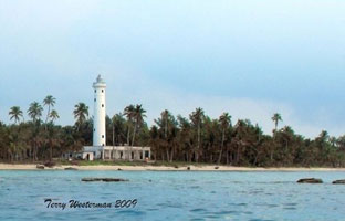
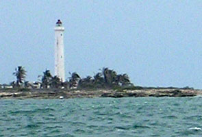
| MX 9 |
Isla de Lobos
The island is located about 40 km southeast of Cabo Rojo in northern Veracruz. Accessible only by boat. (There's also an Isla de Lobos in Peru PE 40
and another one in Uruguay.) UR 5 ARLHS # MEX-035
Photo courtesy Terry Westerman [Tampico] |
|
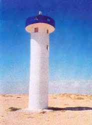
| MX 9o |
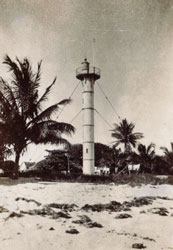
| Isla de Lobos Old (Original Light)
This is the original light.
Photo courtesy Michel Forand [LHDepot] |
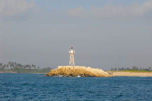
| MX 9T |
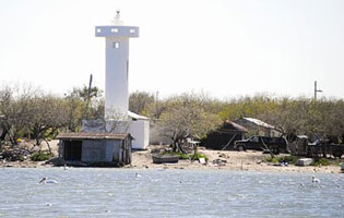
Boca de Carazones (Tamiahua)
The island is located about 15 km southeast of the Punta Grande, (the Big Point) on Cabo Rojo in northern Veracruz.
Note that this is not a lighthouse but otherwise interesting in size and shape.
Photo courtesy Terry Westerman |
|
| MX 10 |
La Barra (1930s) (Túxpan) |
Located on the playa norte (north beach) of Túxpan, somewhere to the north of the present lighthouse. |
| MX 11 |
La Barra (new) (Túxpan)
latitude 20° 58' 18.2" N longitude 97° 18' 25" W
Located on the north side of the entrance to the Río Túxpan in Túxpan. ARLHS # MEX-033
Photo courtesy Carlos [pBase] |
|
| MX 12 |
Barra de Cazones |
Barra de Cazones is a small port about 35 km southeast of Túxpan. ARLHS # MEX-021 |
| MX 13 |
Tecolutla
Located on the Avenida Hidalgo in the center of Tecolutla, a small coastal town at the mouth of the Río Tecolutla about 65 km southeast of Túxpan. ARLHS # MEX-066
Photo courtesy jonw55 [webshots] |
|
| MX 14 |
| Río Nautla
Nautla is on the coast roughly halfway from Cabo Rojo to Veracruz. ARLHS # MEX-065
Photo courtesy Sibyl Lopez [Flickr (March 2007)] |
| MX 15 |
Punta Delgada
latitude 19° 51' 30.2" N longitude 96° 27' 31" W
Located on a headland about 100 km southeast of Nautla. Don't confuse this with the similarly named light in Argentina. AR 23 ARLHS # MEX-179
Photo courtesy Manuel Arrubarrena [Flickr] |
|
| MX 16 |
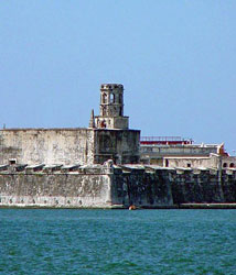
| Veracruz (1796) (San Juan de Ulúa)
latitude 19° 12' 31.3" N longitude 96° 7' 51.9" W
Located on one of the seaward corners of the star-shaped Fuerte de San Juan de Ulúa, the historic fortress that guarded Veracruz from early in the 16th century. The site is one of the principal tourist attractions of the city.
Photo courtesy Bill Masterson [webshots] |
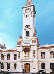
| MX 17 |
Veracruz (1872) (Convento de San Francisco, Faro Benito Juarez)
July 1, 2009
Still recognized as having been a lighthouse, the tower is now called the Faro Benito Juárez. The building is now a historical museum connected to the Holiday Inn. Located on the Calle Benito Juárez y Morelos in downtown Veracruz. |
|
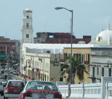
| MX 18 |
| Veracruz (1910) (Faro Venustiano Carranza)
Located on the waterfront (the Malecón) in downtown Veracruz.
Photo courtesy J Livens [webshots] |
| MX 19 |
Isla de Sacrificios
latitude 19° 10' 29" N longitude 96° 5' 32.1" W
July 1, 2009
The lighthouse is on a small island southeast of the harbor of Veracruz; the island is famous as the place where the conquistador Hernan Cortéz landed in 1519. island ARLHS # MEX-145 |
|
|
|
| MX 20 |
| Arrecife Santiaguillo
The island is off the coast about 30 km east southeast of Veracruz. ARLHS # MEX-076
Photo courtesy lauraelana [flickr] |
| MX 21 |
Isla de Enmedio
latitude 19° 6' 4.7" N longitude 95° 56' 20" W |
The island is off the coast about 30 km southeast of Veracruz. Accessible only by boat. photo ARLHS # MEX-032 |
| MX 22 |
Arrecife El Rizo
latitude 19° 3' 21.2" N longitude 95° 55' 13.9" W
Located on a barely-exposed reef about 5 km southeast of the Isla de Enmedio. Accessible only by boat.
Photo courtesy cayucochief [webshots] |
|
| MX 23 |
Alvarado
latitude 18° 46' 56.7" N longitude 95° 44' 46" W |
Lighthouse must mark the entrance to the Laguna de Alvarado, about 40 miles southeast of Veracruz. photo |
| MX 24 |
Roca Partida
Located on a headland at Punta Roca Partida. ARLHS # MEX-068
Photo courtesy 'islapajaros' [webshots] |
|
| MX 25 |
Punta Zapotitlán
latitude 18° 12' 38.1" N longitude 94° 7' 58.1" W |
Punta Zapotitlán is a prominent headland jutting into the Bay of Campeche about 150 km east southeast of Veracruz. photo ARLHS # MEX-063 |
| MX 26 |
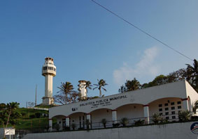
Cerro del Gavilan (Coatzacoalcos, Museo del Faro)
The lighthouse is adjacent to the city museum, which is called the Museo del Faro. Located on a hill southeast of the harbor entrance in the city of Coatzacoalcos. Photo courtesy Uriel Akira
Photo courtesy www.flickr.com/photos/urielakira/ [(Coatzacoalcos, Museo del Faro)] |
|
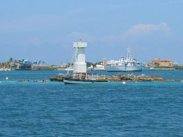
| MX 28 |
Coatzacoalcos East Breakwater
taken from the west breakwater. ARLHS # MEX-182
Photo courtesy Uriel Akira [Flickr] |
|
| MX 29 |
Tonalá |
Located on the west side of the entrance to the Río Tonalá. photo ARLHS # MEX-134 |
Tabasco & Campeche
| MX 30 |
Tupilco |
The lighthouse marks a lagoon entrance west of Paraíso. ARLHS # MEX-135 |
| MX 31 |
Frontera
latitude 18° 36' 46.5" N longitude 92° 41' 18.8" W |
This lighthouse marks the entrance to the Río Grijalva, a major river that has created a small delta called Punta Frontera. Located on the east side of the entrance, about 8 km northwest of the city of Frontera. photo ARLHS # MEX-173 |
| MX 32 |
Xicalango (Range Rear)
latitude 18° 37' 40.4" N longitude 91° 53' 59.1" W |
The range guides vessels into the western entrance to the Laguna de Terminos west of Ciudad del Carmen. Located beside highway 180 about 6 km west of the bridge crossing the inlet from Ciudad del Carmen. photo ARLHS # MEX-138 |
| MX 33 |
Punta Atalaya (Ciudad del Carmen)
Located on the west end of Isla del Cármen, marking the east side of the western entrance to the Laguna de Términos, west of Ciudad del Cármen. ARLHS # MEX-010
Photo courtesy Ninfa Urania [Trekearth] |
|
| MX 34 |

| Punta del Tigre Range Rear (Faro del Tigre, Isla Aguada)
latitude 18° 47' 4.5" N longitude 91° 29' 43.5" W
Located at the northeastern entrance to the Laguna de Términos, about 40 km northeast of Ciudad del Cármen. photo ARLHS # MEX-174
Photo courtesy Alejandro Lopez Ceja [skyscrapercity] |
| MX 35 |
Champotón (Río Champotón)
The lighthouse marks the river entrance in Champotón about 60 km south southwest of Campeche.
Photo courtesy Uriel Akira [Flickr] |
|
| MX 36 |
Punta Morro
latitude 19° 40' 32.8" N longitude 90° 42' 21.1" W |
The lighthouse marks a headland about 30 km southwest of Campeche. ARLHS # MEX-090 |
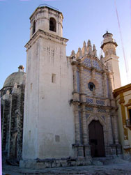
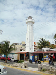
| MX 37 |
Campeche
The lighthouse is one of the two steeples of an 18th century church, the Templo de San José, converted to a light tower. courtesy lol-ita ARLHS # MEX-105
Photo courtesy www.flickr.com/photos/lol-ita/ |
|
| MX 38 |
Isla Arena |
Located on an island just offshore near Calkiní, about 25 km south of Celestún. ARLHS # MEX-107 |
Offshore
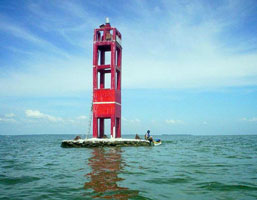
| MX 39 |
Cayos Arcas (Range Rear)
The reef is located in the Bay of Campeche about 160 km west of Campeche city.
Photo courtesy biicusicaru [webshots] |
|
|
|
| MX 40 |
Arrecife Triángulo Oeste (West Triangle Reef) |
The reef is located in the Bay of Campeche about 190 km west of Celestún. reef ARLHS # MEX-002 |
| MX 41 |
Cayo Arenas
The cay is far out in the Gulf about 200 km northwest of El Palmar, the northwesternmost point of the Yucatán Peninsula.
Photo courtesy Morza2006 [webshots] |
|
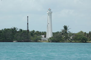
| MX 42 |
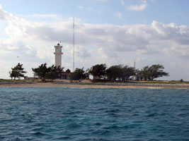
| Isla Pérez
latitude 22° 22' 58.4" N longitude 89° 40' 58.3" W
According to the Spanish text the lighthouse is one of nine cast iron towers built in Mexico by the British firm Chance Brothers. The cay, largest island of the Arrecife Alacrán (Scorpion Reef) is in the Gulf about 50 km northeast of Progreso. cay ARLHS # MEX-085
Photo courtesy Yodigo [Wikimedia] |
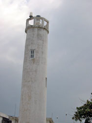
Yucatán
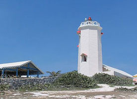
| MX 43 |
Celestún (Cozumel Island)
The second tower is perhaps an older, abandoned lighthouse. Located on the beach in the center of Celestún, which is accessible by a paved road (RF 281) from Mérida.
Photo courtesy CD Summers [webshots] |
|
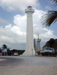
| MX 44 |
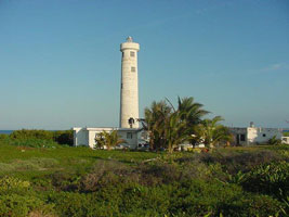
Punta Palmas (El Palmar)
latitude 21° 3' 0.3" N longitude 90° 16' 25.4" W |
This is Mexico's tallest lighthouse. Located at El Palmar, the northwestern corner of the peninsula, north of Celestún. Accessible by boat or by 4WD vehicle over dirt roads from Celestún. photo |
| MX 45 |
Sisal
Located in Sisal, the historic seaport of the Yucatán, about 40 km northwest of Mérida. ARLHS # MEX-019
Photo courtesy s1021201 [webshots] |
|
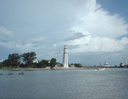
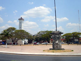
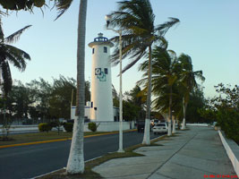
| MX 46 |
| Progreso
Progreso is the modern seaport of the Yucatán, about 32 km north of Mérida. Located in the downtown section of the city, two blocks from the ocean. ARLHS # MEX-086
Photo courtesy gperr007 [Webshots] |
| MX 47 |
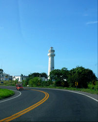
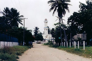
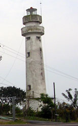
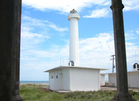
Telchac
Located just off the beach at Telchac Puerto about 55 km east of Progreso. ARLHS # MEX-150
Photo courtesy wallyworldmt [tripAdvisor] |
|
| MX 48 |
Yalkubul
latitude 21° 31' 18.2" N longitude 88° 37' 0.6" W |
Located on the beach about 120 km east of Progreso and 15 mi west of Río Lagartos. It may be accessible only by boat. ARLHS # MEX-092 |
| MX 49 |
Río Lagartos
Located on the tip of a peninsula in Río Lagartos. ARLHS # MEX-129
Photo courtesy cheyox2 [webshots] |
|
| MX 50 |
Monte de Cuyo
latitude 21° 30' 55.6" N longitude 87° 40' 41.5" W |
Located on the main street in El Cuyo, a beach town about 30 miles west of Cabo Catoche. photo ARLHS # MEX-116 |
Quintana Roo
| MX 51 |
Cabo Catoche
latitude 21° 36' 18.2" N longitude 87° 6' 11.5" W
Located at Cabo Catoche, the northeastern tip of Yucatan. Accessible only by boat. ARLHS # MEX-084
Photo courtesy Laura Elena Rosado [Flickr] |
|
| MX 52 |
| Isla Contoy (Qunintana Roo)
latitude 21° 31' 44.2" N longitude 86° 48' 9.8" W
The island, famous for its birds and coral reefs, is about 18 miles north of Isla Mujeres. Tours available from Isla Mujeres. Located at the north end of the narrow island tours ARLHS # MEX-008
Photo courtesy Scott Sichler [Flickr] |
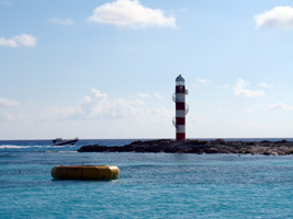
| MX 53 |
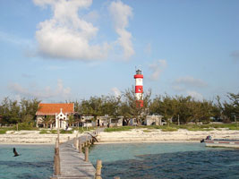
Piedra la Carbonera Range Rear (Isla Mujeres)
This is the taller of the two Isla Mujeres lighthouses, and it stands in the middle of a street intersection. Located at the northwestern point of the island and the north end of the harbor.
Photo courtesy Al [Flickr] |
|
| MX 54 |
| Piedra la Carbonera Range Front
ARLHS # MEX-139
Photo courtesy tripnmonky [webshots] |
| MX 55 |
Isla Mujeres (Punta Sur)
It appears that the keeper's house is now a gift shop. Located in an ecological and historical park at the southern tip of Isla Mujeres. ARLHS # MEX-020
Photo courtesy Melissa McCloud [Flickr] |
|
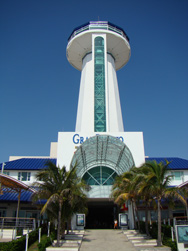
| MX 56 |
| Cancún
Located at Punta Cancún at the northeast point of the resort area.
Photo courtesy Allen Mason [Flickr] |
| MX 56P |
Grand Puerto
Near Puerto Juárez. I'm guessing this is a faux light because it's no listed anywhere, but it sure is striking.
Photo courtesy Allen Mason [Flickr] |
|
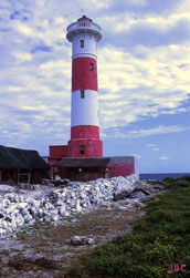
| MX 57 |
| Puerto Morelos (2007)
Located on the beach in Puerto Morelos, about 30 km south of Cancún. ARLHS # MEX-014
Photo courtesy Jubilo Haku [Flickr] |
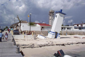
| MX 57o |
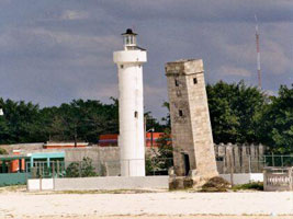
Puerto Morelos (Old)
In 1967 the structure was tilted over in Hurricane Beulah. It has since survived Hurricanes Gilbert in 1987 and Wilma in 2005, but has not been knocked down. The new light house replacing this one is visible in the background.
Photo courtesy Laurie Button [wikitravel] |
|
| MX 58 |
| Punta Molas
latitude 20° 35' 21.2" N longitude 86° 43' 27.6" W
Located at the northern tip of Cozumel; accessible by 4 wheel drive vehicles over a very rough road. ARLHS # MEX-089
Photo courtesy John B Caddell [jbcphotos] |
| MX 59 |
San Miguel de Cozumel (old) (Punta Langosta)
Located on the waterfront, near the cruise ship terminal, in San Miguel de Cozumel on the west side of the island. ARLHS # MEX-131
Photo courtesy John B Caddell [jbcphotos] |
|
| MX 61 |
Punta Celeraín
Located in an ecological reserve at the southern end of the island of Cozumel. ARLHS # MEX-088
Photo courtesy John B Caddell [jbcphotos] |
|
| MX 62 |
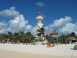
| Playa del Carmen
latitude 20° 37' 44.3" N longitude 87° 3' 58.9" W
Located in a resort on the beach at Playa del Carmen. ARLHS # MEX-146
Photo courtesy sensi1 [Flickr] |
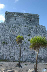
| MX 63 |
Tulum
About 1200 AD. Rubblestone pyramid crowned by a square temple structure with two small openings facing the sea. Built by the Maya, this structure was used ingeniously as a lighthouse to guide returning fisherman. ARLHS # MEX-080
Photo courtesy John B Caddell [jbcphotos] |
|
| MX 64 |
| Punta Allen
The lighthouse is in the village of Punta Allen about 40 km south of Tulum, marking the entrance to the Bahía de la Ascensión. ARLHS # MEX-048
Photo courtesy Yvonne Riba [Flickr] |
| MX 65 |
Punta Herrero |
Punta Herrero is at the end of a long, northward-pointing sand spit that encloses the Laguna del Espíritu Santo. Located at the end of the road in Punta Herrero. photo ARLHS # MEX-056 |
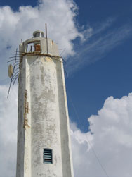
| MX 65A |
Mahahual
Not much is known about this light. The description in the NGA list describes the metal tower, not the tall concrete one.
Photo courtesy ahl961 [webshots] |
|
| MX 66 |
| X'calak
The name is pronounced 'shkalak'. Located at X'calak, the southernmost point of Quintana Roo, across from Ambergris Cay, Belize. Accessible by ferry from Chetumal. ARLHS # MEX-137
Photo courtesy Riona MacNamara [Flickr] |
| MX 67 |
Ciudad Chetumal (Payo Obispo)
Located on Boulevard Bahía in downtown Chetumal ARLHS # MEX-028
Photo courtesy Gabriel Joaquin Herrera Jimenez [Flickr] |
|
Banco Chinchorro
| MX 67B |
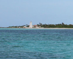
| Banco Chinchorro (Cayo Norte)
Banco Chinchorro is a complex of coral reefs and cays about 40 km long and up to 16 km wide, located about 25 km off Mexico's extreme southeast coast. The reefs have claimed countless shipwrecks since the earliest days of Spanish exploration in the region. The light is in the extreme North of the reef.
Photo courtesy Scott Sichler [Flickr] |
| MX 67C |
Cayo Centro |
Cayo Centro is an island in the center of the reef complex. |
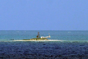
| MX 67L |
Cayo Lobos
Cayo Lobos is at the extreme south end of the reef. (J 4456.7)
Photo courtesy Captain Theo [ListOfLights] |
|
|
|
 Mexico West
 Texas
Texas