|
This page the documentation about the Lighthouses of Haiti. In addition, the pictures below are linked to the relevant photo on the web (thus making available to you a higher resolution picture.) I am very grateful to Russ Rowlett at the University of North Carolina for his excellent Lighthouse Directory from which I built the outline. Each lighthouse is linked to (in our editorial opinion) the best reference site for that light. LHdirectory |
|
| HH 1 |
Île Vache (Île-à-Vaches) |
Île Vache is an island about 8 miles long lying off Haiti's southwestern peninsula. The island has several resorts, among the few in Haiti. Located at the eastern tip of the island. |
| HH 2 |
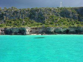
Pointe Gravois |
Located at the southwestern tip of the Gravois peninsula in far southwestern Haiti |
| HH 3 |
Grande Cayemite (Grande Île des Cayemites) |
Grand Cayemite is about 8 by 3 miles elliptical, lying in the Gulf of Gonâve off the north coast of Haiti's southwestern peninsula. Located at the northern tip of the island. |
| HH 4 |
Pointe Ouest
This lighthouse warns ships approaching the Île de la Gonâve, a large island in the Gulf of Gonâve west of Port-au-Prince. The island is 37 miles long and 9 wide. Located on the western point of Île de la Gonâve.
Photo courtesy Francis Mitchell [panoramio] |
|
|
|
| HH 5 |
Pointe du Lamentin |
The lighthouse is located on a peninsula jutting into the Baie de Port-au-Prince at Carrefour, about 5 km west of the city. Carrefour is a very poor neighborhood and casual travel there is not advisable, but the lighthouse should be visible from ships arriving in Port-au-Prince. photo |
| HH 6 |
Port au Prince |
Located on the heights behind Port-au-Prince on the southwest corner of Fort Alexandre. |
| HH 7 |
Port au Prince Range Front |
This light was attached to the cupola atop the north tower of the Cathedral.That cathedral was destroyed January 12, 2010 in the devastating earthquake. |
|
|
| HH 8 |
Les Arcadins (Ile Du Phare) |
The three small islands known as the Arcadins are hazards in the Canal de Saint-Marc (St. Mark Channel), which separates the mainland from the Île de Gonâve, about 30 km northwest of Port-au-Prince. Located on the Île du Phare, the central and largest of the three islands. |
| HH 9 |
Pointe de Saint-Marc |
This light marks the entrance to the Canal de Saint-Marc (St. Mark Channel). Located on the point, about 20 km southwest of Saint-Marc. |
| HH 10 |
Pointe Lapierre |
Located on a steep headland on the north side of the entrance to the Baie de Gonaïves, about 15 km west of the city of Gonaïves |
| HH 11 |
Pointe Picolet (1895) |
Prefabricated in France, this lighthouse was a remarkable architectural monument. The active lighthouse at Ruhnu, Estonia, is the only other known surviving quadrupod tower. Located on a promontory sheltering the harbor of Cap-Haïtien, on the north coast of Haiti. |
| HH 12 |
Pointe Picolet (new)
latitude 19° 46' 59.1" N longitude 72° 11' 26.2" W |
|
| HH 13 |
Cap du Mole St. Nicolas |
Located on the extreme northwestern tip of the island facing the Windward Passage. |
|
|
 Mexico
 Florida