|
This page shows the documentation of the Southern Lighthouses of West Norway. You can always click on the photo of the light to go to a specific (larger resolution) copy. Each lighthouse name is linked to (in our editorial opinion) the best reference site for that light. I would like to include directions on how to get to these lights. If you know such data, could you eMail me and I'll post it here (with your choice of attribution.) There has been significant usage of the Lighthouse Directory prepared by Russ Rowlett (UNC). LHDirectory Lighthouse coordinates and orange reference numbers are via Norsk Fyr. My thanks to them for providing this basis for understanding. NorskFyr |
|
Vågsøy Area
Map is WS4
| NO 450 |
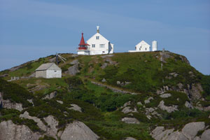
Honningsvåg
latitude 62° 11' 53.4" N longitude 5° 10' 42" E |
Stadtlndets Northeast side (L 0526) [295000] |
| NO 451 |
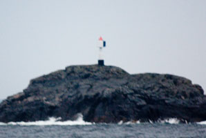
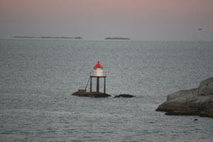
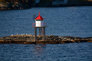
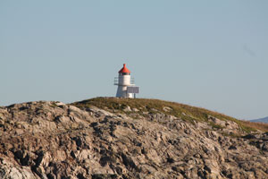
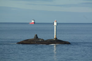
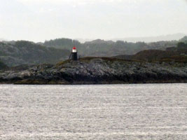
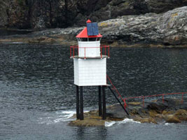
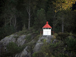
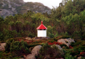
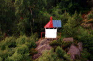
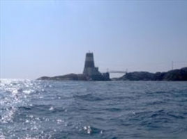
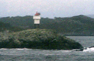
Buholmen
latitude 62° 10' 8.3" N longitude 5° 4' 50.7" E
October 5, 2010
Buholmen is a prominent cape at the end of a long peninsula about 20 km northwest of Selje, at the extreme northwest corner of Sogn og Fjordane. Located on a skerry off the tip of the cape. Practically inaccessible in heavy seas, but there's a good view from the tip of the cape, which is apparently accessible by hiking trail.
This picture was taken from the Hurtigruten ferry before breakfast. (L 0520) [294000] |
|
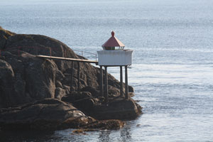
| NO 452 |
Selje
latitude 62° 3' 4.8" N longitude 5° 20' 42" E |
At Grytingnes (L 0516) [292000] |
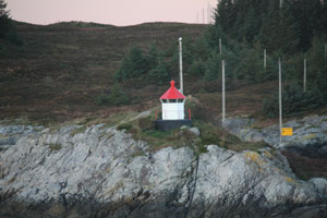
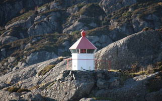
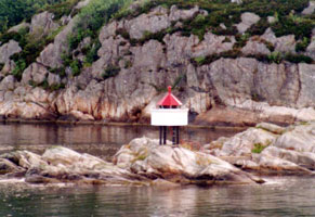
| NO 453 |
Saltnes
latitude 62° 1' 58.2" N longitude 5° 20' 37.8" E |
Inlet to Modefjord (L 0514) [291300] |
| NO 454 |
Silda Hamn
latitude 62° 48" N longitude 5° 12' 16.8" E |
Silda is a small island in the sound called the Sildegapet, northeast of the island of Vågsøy. A small village on the island is accessible by ferry from Vågsøy. Located at the end of the north breakwater of Silda. (L 0510) [291000] |
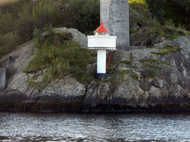
| NO 455 |
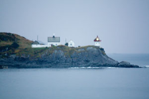
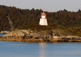
Ulvesund (Hjertneset Range Front)
latitude 61° 59' 6" N longitude 5° 10' 7.2" E |
The station is now available for overnight accommodations. Located on the east side of the entrance to Ulvesund, about 8 km north of Vågsøy. Accessible by road. (L 0498) [289000] ARLHS # NOR-260 |
| NO 456 |
Ulvesund Ovre (Range Rear)
latitude 61° 59' 2.4" N longitude 5° 10' 9" E |
Located 90 m uphill and behind the Ulvesund lighthouse. (L 0498.1) [289100] ARLHS # NOR-403 |
| NO 457 |
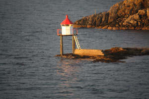
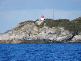
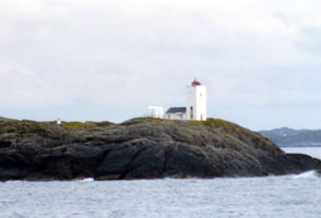
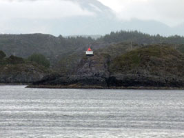
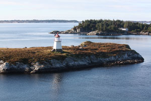
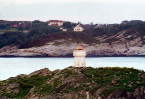
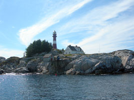
Skongenes
latitude 62° 1' 56.4" N longitude 5° 7' 24.2" E
October 5, 2010
Ytre Nordfjord Turlag provides transportation and offers guided tours to this light station, but there doesn't appear to be road access. Located on the northern tip of the island of Vagsøy. tours (L 0508) [290000] ARLHS # NOR-209 |
|
| NO 458 |
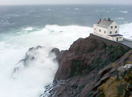
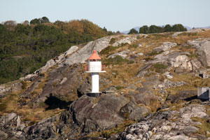
| Kråkenes
latitude 62° 2' 5.4" N longitude 4° 59' 9" E
The current lighthouse now houses a restaurant and has rooms available for overnight accommodations. restaurant
Located at the northwestern point of the island of Vagsøy, on a spectacular knifelike promontory. (L 0504) [290500] ARLHS # NOR 141
Photo courtesy Merete Høidal [Flickr] |
NO 459
[NO234] |
Hendanes (Vågsøy Nord)
latitude 61° 57' 52.8" N longitude 5° 2' 3" E |
Located on a promontory at the entrance to the Kvalheimsvika, about 3 km northwest of Vågsvåg on the island of Vågsøy. Accessible by a walk of about ½ mi from the end of the road off highway 601 north of Vågsvåg. (L 0472) [284000] ARLHS # NOR-116 |
NO 460
[NO 231S] |
Hovdeneset
latitude 61° 55' 34.2" N longitude 5° 1' 25.8" E |
Husevågøy northern point (L 0476) [283000] |
NO 461
[NO 231K] |
Kvitnes
latitude 61° 54' 21.4" N longitude 5° 1' 15.9" E |
Husevågøy west side (L 0420) [282000] |
NO 462
[NO 231V] |
Bergsholmane
latitude 61° 55' 34" N longitude 5° 3' 18.8" E |
Vågsøy south side at Bergsholmen (L 0480) [283200] |
NO 463
[NO 232] |
Søre Maløy |
This light and the next are on Maløy, a small island in the harbor of Vågsøy, which is part of the Ulvesund. [286200] |
NO 465
[NO233U] |
Ulven
latitude 61° 57' 45" N longitude 5° 8' 55.8" E |
Southeast side of the Vågsøy (L 0494) [288000] |
| NO 466 |
Skavøypollen
latitude 61° 54' 56.6" N longitude 5° 8' 21.6" E |
North side of the inner entrance to Skavøypollen north. (L 0482) [285500] |
NO 467
[NO 230L] |
Allmenningsflu
latitude 61° 54' 12.6" N longitude 5° 15' 24.6" E |
At the entrance of Nordfjord on the north side. (L 0442) [279000] |
NO 468
[NO 230S] |
Åsnes |
At the inlet to Davikfjorde - Nordfjord on the north side. (L 0446) [279200] |
NO 469
[NO 231] |
Reksnes |
Located at the end of the mole at Reksnes, a village on the north side of the Nordfjord about 40 km west of Vågsøy. (L 0448) [279400] |
NO 471
[NO 231D] |
Anden
latitude 61° 50' 48.3" N longitude 6° 4' 42.2" E |
Gloppefjord - Norfjord (L 0462) [280400] |
NO 472
[NO 231A] |
Ålfoten |
West Gjegnalund. Ålfotenfjord inlet to Norfjord (L 0456) [279800] |
NO 474
[NO 226H] |
Hornelen
latitude 61° 50' 1.5" N longitude 5° 15' 1" E |
Bremangers southeast side (L 0438) [276000] |
NO 475
[NO 226K] |
Kalveholmen
latitude 61° 52' 22.8" N longitude 5° 13' 29.8" E |
Holmens south side (L 0432) [277200] |
NO 476
[NO 229] |
Skaten
latitude 61° 52' 24" N longitude 5° 12' 42" E |
Located on the south side of the Skatestraumen, the channel separating the islands of Bremangerlandet and Rugsundsøy, about 5 km southeast of Vågsøy. (L 0430) [277400] |
NO 477
[NO 230] |
Risøy
latitude 61° 52' 46.8" N longitude 5° 10' 28.8" E |
Located at the westernmost point of Rugsundsøy, marking the western entrance to the Skatestraumen, about 4 km south southeast of Vågsøy. (L 0426) [277600] |
NO 479
[NO 225] |
Øksneset
latitude 61° 52' 32.4" N longitude 4° 52' 1.2" E |
Bremangerpollen (L 0414) [274000] |
NO 480
[NO 225i] |
Iglandsvik
latitude 61° 50' 3.6" N longitude 4° 56' 34.2" E |
Bremanger west side (L 0410) [272000] |
Kalvåg Area
NO 483
[NO 227T] |
Oldesteinen
latitude 61° 47' 33" N longitude 4° 53' 52.2" E |
Oldersundet (L 0398) [271000] |
NO 484
[NO 226] |
Minnet
latitude 61° 46' 18.6" N longitude 4° 50' 19.8" E |
Located on a promontory on the southwest side of Frøya, about 2 km west of Kalvåg. (L 0378) [274500] |
NO 485
[NO 227] |
Kalvåg
latitude 61° 46' 7.2" N longitude 4° 52' 60" E |
This light guides ships approaching Kalvåg from the mainland. Located on the southeast side of the island of Frøya, about 500 m east of the Kalvåg waterfront. (L 0378.2) [269800] |
NO 486
[NO 227K] |
Sparkeltaren
latitude 61° 46' 2.4" N longitude 4° 53' 54.6" E |
Oldersundet (L 0384) [270000] |
NO 487
[NO 228] |
Smørhavn
latitude 61° 45' 43.5" N longitude 4° 55' 46.5" E |
Located at the southwestern point of Fiskholmen, marking the north side of the entrance to the Frøysjøen sound. Accessible by road from Bremanger. (L 0386) [269300] ARLHS # NOR 217 |
NO 488
[NO 224D] |
Ospenes
latitude 61° 45' 40.2" N longitude 5° 5' 44.4" E |
Nesets south point (L 0360) [268000] |
NO 489
[NO 224H] |
Holmane
latitude 61° 45' 51.6" N longitude 5° 9' 47.4" E |
Storholmens northwest side (L 0364) [268300] |
NO 490
[NO 224] |
Sør Botnen
latitude 61° 43' 24" N longitude 4° 58' 14.4" E |
Located on a point of land marking the south side of the entrance to the Frøysjøen sound, about 8 km north northwest of Florø. (L 0356) [267500] |
NO 491
[NO 223A] |
Olaskjær
latitude 61° 43' 31.2" N longitude 4° 56' 53.4" E |
On south Olaskjær (L 0354) [266500] |
NO 492
[NO 223] |
Kvanhovden
latitude 61° 41' 49.8" N longitude 4° 49' 52.8" E |
Located at the northwestern point of the island of Hovden, about 15 km northwest of Florø. (L 0350) [266000] ARLHS # NOR 143 |
NO 493
[NO 222P] |
Dombeskjærene
latitude 61° 39' 55.8" N longitude 4° 50' 26.4" E |
Southwest on Hovden (L 0349) [265900] |
NO 494
[NO 222E] |
Drågjaskjerflu
latitude 61° 39' 3" N longitude 4° 58' 32.4" E |
Nærøysundet (L 0332) [258900] |
NO 495
[NO 222F] |
Seljestokken
latitude 61° 39' 57.6" N longitude 4° 58' 43.4" E |
Klenevågneset, Nærøysundet (L 0334) [259500] |
Florø Area
NO 496
[NO 222D] |
Årebrott
latitude 61° 37' 39.8" N longitude 4° 59' 27.9" E |
On Årebrottnes, north of Florø (L 0330) [258500] |
NO 497
[NO 222H] |
Ysteviknes
latitude 61° 38' 24" N longitude 4° 46' 42.6" E |
Batalden southwest side (L 0346) [261500] |
NO 498
[NO 222J] |
Værholmen
latitude 61° 37' 55.8" N longitude 4° 48' 58.2" E |
On the north tip of the island, southeast of Batalden (L 0344) [261800] |
NO 499
[NO 222K] |
Strømøy
latitude 61° 37' 3.6" N longitude 4° 49' 29.4" E |
Northwest of Skorpa (L 0345) [261900] |
NO 500
[NO 222G] |
Teisthalsen
latitude 61° 36' 39.5" N longitude 4° 48' 30.5" E |
Northwest of Skorpa (L 0335) [260000] |
NO 501
[NO 222N] |
Notholmen
latitude 61° 34' 60" N longitude 5° 26' 12" E |
Inlet to Eikefjord (L 0328) [265500] |
NO 502
[NO 222M] |
Helgøy
latitude 61° 36' 30" N longitude 5° 14' 54" E |
On the north side of the island Helgøysundet in Eikefjord (L 0327) [265000] |
NO 503
[NO 222C] |
Sjufotsbåen
latitude 61° 36' 30" N longitude 5° 3' 31.2" E |
Langholmsundet, Florø (L 0325) [257400] |
NO 504
[NO 222B] |
Florø
latitude 61° 36' 12" N longitude 5° 36.6" E
October 15, 2010
On Rotaflu north of Florø. There is a string of red caps as you travel west from Florø, but this is the most significant. (L 0323) [257200] |
|
NO 505
[NO 222A] |
| Grasskjær
latitude 61° 36' 10.2" N longitude 4° 57' 55.1" E
October 15, 2010
West of Florø (L 0320) [257000] |
NO 506
[NO 222] |
Stabben
latitude 61° 36' 2.4" N longitude 4° 57' 18.6" E
October 15, 2010
Automated in 1975, the lighthouse is leased as a vacation residence by a company in Florø. Located in the fjord about 2 km west of the Florø waterfront. (L 0318) [256600] ARLHS # NOR 221 |
|
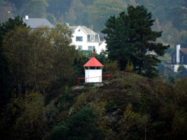
NO 506A
[NO 506N] |
Ånøyskjær
latitude 61° 35' 47.4" N longitude 4° 56' 16.2" E |
West of Florø (L 0317) [253300] |
NO 506N
[NO 219Y] |
Nekkøyosen
latitude 61° 34' 53.2" N longitude 4° 56' 51.2" E |
Haneholmen west of Florø (L 0313) [254200] |
NO 506Y
[NO 219L] |
Æsøysundet
latitude 61° 34' 59.4" N longitude 4° 47' 0.6" E |
Skorpas southwest side (L 0308) [252800] |
NO 508
[NO 221] |
Ytterøyane
latitude 61° 34' 15" N longitude 4° 40' 48" E |
Located on an isolated island in the Atlantic about 20 km west of Florø. (L 0298) [251500] ARLHS # NOR-283 |
NO 510
[NO 219] |
Sandøya (Kinn)
latitude 61° 33' 3" N longitude 4° 45' 50" E |
Located on a small island about 4 km west of Vaerlandet. Accessible only by boat, although there is a small settlement on the island. (Don't confuse with the light below.) NO534 (L 0304) [251900] |
NO 512
[NO 220T] |
Gjesnes
latitude 61° 28' 39.2" N longitude 5° 39' 42.8" E |
South side of Førdefjorden (L 0286) [249000] |
NO 513
[NO 220R] |
Hellenes
latitude 61° 27' 17.5" N longitude 5° 28' 50.7" E |
North side of Førdefjorden (L 0282) [248900] |
NO 514
[NO 220Q] |
Flokenes
latitude 61° 28' 57" N longitude 5° 13' 50.4" E |
East of Flokeneset (L 0278) [248500] |
NO 515
[NO 220P] |
Stavangsund
latitude 61° 32' 20.4" N longitude 5° 9' 40.2" E |
Stavang (a very little rock), southeast of Stavøya (L 0290) [248000] |
NO 516
[NO 220N] |
Kvanskjæret
latitude 61° 31' 6.3" N longitude 4° 52' 52.2" E |
West of Askrova (L 0271) [247400] |
NO 517
[NO 220K] |
Askrova
latitude 61° 30' 35.5" N longitude 4° 59' 45.4" E
October 15, 2010
On the east point of Askrova island (L 0274) [247200] |
|
NO 518
[NO 220J] |
Treforskjer
latitude 61° 29' 2" N longitude 4° 59' 35" E |
West from Svanøya (L 0272) [247000] |
NO 519
[NO 220H] |
Stavenes
latitude 61° 24' 54" N longitude 4° 58' 31.8" E |
Inlet to Strongfjord (L 0252) [246400] |
NO 520
[NO 220F] |
Raudøy vestpynt (west point)
latitude 61° 23' 15.5" N longitude 4° 57' 40.3" E |
North from Atløy (L 0255) [246200] |
NO 521
[NO 220D] |
Heggøy
latitude 61° 23' 12.6" N longitude 4° 55' 31.2" E |
North from Atløy (L 0258) [246000] |
NO 522
[NO 218T] |
Trettenes
latitude 61° 22' 34.2" N longitude 5° 1' 36" E |
East side of Granesundets (L 0244) [245000] |
NO 523
[NO 220B] |
Hindøysund
latitude 61° 22' 14.8" N longitude 4° 53' 42.2" E |
Northwest from Atløya (L 0264) [245700] |
Florø Area and Sognefjord
Map is W3
NO 524
[NO 218N] |
Halsnes
latitude 61° 22' 29.3" N longitude 5° 32' 3.8" E |
Inner Dalsfjord. (L 0238) [244500] |
NO 525
[NO 218K] |
Dalsøya
latitude 61° 21' 54.6" N longitude 5° 19' 46.8" E |
South side of Dalsfjord. (L 0236) [244400] |
NO 526
[NO 218H] |
Sveskjærene
latitude 61° 18' 29.5" N longitude 5° 10' 30.9" E |
South side of Dalsfjord. (L 0234) [244200] |
NO 527
[NO 218F] |
Vinesfjord
latitude 61° 18' 16.3" N longitude 5° 3' 23.6" E |
By Furenes (L 0232) [243400] |
NO 528
[NO 218P] |
Granesund
latitude 61° 19' 55.9" N longitude 5° 3' 17.6" E |
Prestøy, Askvoll (L 0242) [244800] |
NO 529
[NO 217A] |
Austnesholmen
latitude 61° 17' 34.2" N longitude 4° 47' 0.6" E |
East of Værøy (L 0216) [240100] |
|
|
| NO 530 |
Austnes
latitude 61° 17' 10.2" N longitude 4° 46' 37.8" E
October 15, 2010
Located at the eastern tip of Vaerlandet, an island about 20 km west southwest of Askvoll. The island is accessible by passenger ferry from Askvoll, and the light is accessible by a hiking trail. (L 0214) [240000] |
|
NO 531
[NO 217P] |
Olsund
latitude 61° 17' 36.6" N longitude 4° 39' E |
Bratholmens west side (L 0208) [241800] |
NO 532
[NO 217H] |
Hovden
latitude 61° 16' 55.8" N longitude 4° 38' 36.6" E |
South portion of Bulandet (L 0210) [241600] |
NO 533
[NO 218D] |
Raudøy
latitude 61° 18' 0.6" N longitude 4° 54' 11.4" E |
Vinesfjorden (L 0228) [243000] |
NO 534
[NO 217S] |
Sandøy (Bulanadet) |
Bulandet west side (see almost matching light above) NO510 (L 0202) [242000] |
NO 535
[NO 218] |
Gjørines |
Located on the northeastern corner of a small island 2 km west of Vaerlandet. (L 0206) [242200] |
NO 536
[NO 216] |
Geita
latitude 61° 16' 9" N longitude 4° 48' 40.2" E
The lighthouse is available for lease by artists. Located on an island in the Aspefjord about 8 km west of Korssund. Accessible only by boat. lease (L 0220) [239600] ARLHS # NOR 093
Photo courtesy Jorn H. Andersen |
|
NO 537
[NO 215] |
Skifjorden
latitude 61° 14' 20.4" N longitude 5° 1' 35" E |
Located on the south side of the entrance to the Skifjord, a narrow passage about 4 km southeast of Korssund. (L 0196) [238900] |
NO 538
[NO 214S] |
Sakrisskjær
latitude 61° 13' 30.6" N longitude 4° 57' 18" E |
Åfjorden (L 0192) [238600] |
NO 539
[NO 214G] |
Smilden
latitude 61° 12' 48" N longitude 5° 13' 12.6" E |
Åfjord (L 0194) [238200] |
NO 540
[NO 214E] |
Storakersund
latitude 61° 10' 10.2" N longitude 5° 4' 27" E |
Losnosen (L 0066) [238000] |
NO 541
[NO 214N] |
Buskøygavlen
latitude 61° 13' 12.6" N longitude 4° 51' 30.6" E |
Buskøys north point (L 0186) [238500] |
NO 542
[NO 214J] |
Steinsøy
latitude 61° 12' 36.6" N longitude 4° 51' 10.8" E |
Færøyosen (L 0188) [238300] |
NO 543
[NO 220] |
Tussen |
Located on a skerry about 3 km northwest of the island of Autløy. Accessible only by boat in heavy seas. (L 0268) [245500] |
NO 544
[NO 213V] |
Notskjæret
latitude 61° 12' 22.8" N longitude 4° 49' 23.4" E |
Lågøyfjorden, Færøy (L 0177) [236000] |
NO 545
[NO 213T] |
Skomakeren
latitude 61° 12' 5.4" N longitude 4° 47' 19.2" E |
Lågøyfjorden (L 0176) [235500] |
NO 546
[NO 213S] |
Saltskår
latitude 61° 11' 34.2" N longitude 4° 47' 52.8" E |
Lågøyfjorden (L 0172) [234800] |
NO 547
[NO 213R] |
Ospøytåa
latitude 61° 13' 19.8" N longitude 4° 43' 14.4" E |
Northwest of Ospa (L 0171) [234500] |
NO 548
[NO 213U] |
Ospøy
latitude 61° 12' 1.8" N longitude 4° 47' 15" E |
Lågøyfjorden (L 0174) [235600] |
NO 549
[NO 214] |
Seglsteinen
latitude 61° 9' 20.4" N longitude 5° 1' 6.6" E |
Krakhellesund (L 0062) [236700] |
NO 550
[NO 213X] |
Klauva
latitude 61° 7' 18.6" N longitude 5° 1' 49.8" E |
Krakhellesundets south end. Distant views may be possible from the Krakhella - Rutledalen ferry, otherwise it looks like a long walk to get here from any civilization. (L 0060) [236500] |
NO 552
[NO 205S] |
Bøfjord
latitude 61° 7' 23.2" N longitude 5° 20' 23" E |
Bråstadneset, Sognefjorden (L 0072) [220100] |
NO 555
[NO 211] |
Sæleneset |
Located on the north side of the Sognefjord about 15 km southwest of Balestrand. The site may be difficult to reach, but it appears the lighthouse can be spotted from highway 55 along the fjord. (L 0096) [222000] |
NO 556
[NO 208] |
Veganes |
Located on a promontory near the northern terminal of the ferry carrying highway 13 across the Sognefjord, about 2 km northeast of Balestrand. (L 0104) [222100] |
NO 562
[NO 209] |
Nes |
Located at a fork of the Lustrafjord, a northeastern branch of the Sognefjord, about 5 km east of Gaupne. The site is close to highway 55, but access appears to be through private property. (L 0146) [225400] ARLHS # NOR-171 |
NO 563
[NO 210] |
Havhella |
Located on the south side of the Lustrafjord about 4 km east of Luster. Accessible by road. (L 0148) [225600] |
NO 564
[NO 207] |
Fretheim (Aurlandsfjord) |
Located at the head of the Aurlandsfjord in Fretheim, about 5 km southwest of Aurlandsvangen. (L 0130) [224200] |
NO 566
[NO 206] |
Arnafjord |
Located on the south side of the Sognefjord, marking the east side of the entrance to the Arnafjord, about 8 km west of Viksøyri. (L 0100) [221800] ARLHS # NOR-445 |
NO 567
[NO 205T] |
Ortneset |
Risnefjorden, Sognefjorden
Admiralty coordinates put this in the water, but Google shows nothing there. To the south, there's a point that would be a likely place. (L 0082) [220800] |
NO 569
[NO 205K] |
Kråkeneset
latitude 61° 3' 21.6" N longitude 4° 56' 10.2" E |
North side of Sognesjøen (L 0030) [219200] |
NO 570
[NO 213i] |
Indre Steinsund
latitude 61° 3' 33" N longitude 4° 49' 18" E |
Southwest of Sula (L 0022) [229500] |
NO 571
[NO 213J] |
Taskholmen
latitude 61° 5' 49.3" N longitude 4° 49' 12.6" E |
On the south end of a small rock in Indre Steinsund. (L 0024.8) [230300] |
NO 572
[NO 213K] |
Vardeholmen
latitude 61° 8' 57.5" N longitude 4° 47' 33" E |
North of Indre Steinsund (L 0025.4) [231500] |
NO 573
[NO 213M] |
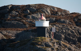
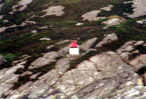
Olderkalven
latitude 61° 7' 27" N longitude 4° 44' 28.8" E
October 15, 2010
The island at Småskjærtarene, ytre Steinsund is almost smaller than the lighthouse. (L 0167) [233000] |
|
NO 574
[NO 213N] |
Storøyna
latitude 61° 5' 57.6" N longitude 4° 42' 16.2" E |
Ytre Steinsund. It looks like there is a road to this light on the east side of the island. (L 0162) [233500] |
NO 575
[NO 213L] |
Larsråholmen
latitude 61° 6' 47.1" N longitude 4° 45' 2.4" E |
Located near the south end of a small island north of ytre Steinsund. (L 0164) [232800] |
NO 576
[NO 213] |
Øisundet
latitude 61° 5' 30.6" N longitude 4° 40' 59.5" E |
This light faces the North Sea on a small island just north of Ytre Sula. (L 0160) [228200] |
NO 577
[NO 213F] |
Fængskjær
latitude 61° 2' 21.6" N longitude 4° 44' 29.7" E
October 15, 2010
This and the light above are the opposite sides of a very narrow channel. (L 0019) [229000] |
|
NO 578
[NO 213E] |
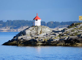
| Ytre Steinsund
latitude 61° 2' 10.8" N longitude 4° 44' 30" E
October 15, 2010
On a small rock at Bratholmen, Ytre Steinsund. This photo is taken from the Hurtigruten southbound ferry traveling to Bergen. (L 0018) [228800] |
NO 579
[NO 213Q] |
Lyngøy
latitude 61° 10' 3" N longitude 4° 43' 14.4" E |
Lågøyfjorden (L 0170) [234000] |
NO 580
[NO 213P] |
Kråkestein
latitude 61° 9' 19.8" N longitude 4° 39' 21" E |
West of Lågøyfjorden (L 0168) [233800] |
NO 581
[NO 210S] |
Syltholmen
latitude 61° 2' 17.7" N longitude 4° 38' 24.2" E |
West of Ytre Sula (L 0006.6) [226000] |
NO 582
[NO 212] |
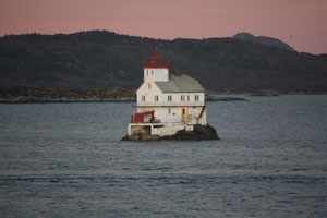
Utvær |
Located on a small, rocky island about 6.5 km due west of Ytre Sula. Accessible only by boat, but guided tours are available. tours (L 0004) [226400] ARLHS # NOR-345 |
NO 583
[NO 212L] |
Legøyna
latitude 61° 48.2" N longitude 4° 40' 10" E |
Strømfjorden, Ytre Sula (L 0008) [226800] |
NO 584
[NO 205] |
Stavsneset Eivendvik |
Located on a promontory marking the entrance to a narrow channel leading to the village of Eivendvik, about 2 km west of the town. (L 0046) [217600] |
NO 585
[NO 212S] |
Søre Nåsa
latitude 60° 59' 57.8" N longitude 4° 39' 26" E |
Straumen, Ytre Sula (L 0012) [227600] |
NO 586
[NO 212Y] |
Lilleholmen
latitude 61° 27" N longitude 4° 37' 2.4" E |
Southwest from Ytre Sula (L 0007) [228000] |
NO 587
[NO 213D] |
Kværeknapp
latitude 60° 58' 58.3" N longitude 4° 42' 26.9" E |
Sognesjøen, south of Ytre Sula (L 0014) [228500] |
NO 588
[NO 203Z] |
Storholmen
latitude 60° 57' 59.5" N longitude 4° 59' 31.2" E |
South of Hiserøynas (L 0040) [216700] |
NO 589
[NO 203Y] |
Syllingsvåg
latitude 60° 59' 17.8" N longitude 4° 55' 33.3" E |
Hiserøynas west side (L 0038) [216500] |
NO 590
[NO 204] |
Folefoten
latitude 60° 58' 22.8" N longitude 5° 2' 9.6" E |
Southeast of Hiserøynas (L 0042) [217500] |
NO 591
[NO 203X] |
Vassøyna
latitude 60° 57' 1.6" N longitude 4° 56' 11.3" E |
Northwest of Sandøy (L 0034) [216000] |
NO 592
[NO 203M] |
Sogneuksen
latitude 60° 56' 40.9" N longitude 4° 45' 22.8" E
October 15, 2010
Sognesjøen [209500] |
|
NO 593
[NO 203L] |
Bardvågen
latitude 60° 53' 51" N longitude 4° 49' 48.8" E |
West side of Byrknesøy (B 4242) [209000] |
NO 594
[NO 203J] |
Røytingkalven
latitude 60° 52' 21" N longitude 4° 46' 47" E
October 15, 2010
Broseosen, Fensfjorden (B 4238) [207900] |
|
NO 595
[NO 203K] |
Ærholmen
latitude 60° 52' 29.8" N longitude 4° 51' 47.6" E |
West of Byrknesøy (B 4243.6) [208300] |
NO 596
[NO 203Q] |
Vikingneset
latitude 60° 51' 15.8" N longitude 4° 55' 58.3" E
South of Byrknesøy (B 4252) [211500]
Photo courtesy Mike Boucher [ListofLights] |
|
Northern Hordaland
Map is W2
NO 608
[NO 203P] |
Hageskjeret
latitude 60° 48' 31.2" N longitude 4° 56' 34.2" E
Fløtevik, Fensfjorden (B 4248) [210000]
Photo courtesy Mike Boucher [ListofLights] |
|
NO 609
[NO 203H] |
| Grimeskjæret
latitude 60° 50' 54.4" N longitude 4° 45' 10.5" E
October 15, 2010
Fensfjorden. Note the stump of the old light still surviving on this rock. (B 4237) [207801] |
NO 610
[NO 203] |
Holmengrå
The keeper's house is available for overnight accommodations. Located on a small island in the open Atlantic off the mouth of the Fensfjord, about 5 km northwest of Fedje. Accessible only by boat. (B 4156) [201500] ARLHS # NOR-123
Photo courtesy Alex Trabas [listOfLights] |
|
NO 612
[NO 203F] |
Teistholmen
latitude 60° 48' 52.2" N longitude 4° 46' 30" E
Rongevær, northwest of Fosnøy (B 4234) [207200]
Photo courtesy Arno Siering [ListofLights] |
|
NO 613
[NO 203E] |
Rongeværsund
latitude 60° 49' 24.7" N longitude 4° 47' 36" E |
Lamholmen, northwest of Fosnøy (B 4232) [207000] |
NO 614
[NO 203D] |
Rongevær
latitude 60° 48' 20" N longitude 4° 47' 45.5" E |
Northwest of Fosnøy (B 4230) [206500] |
|
|
NO 618
[NO 200S] |
Mågøy Vestra |
The southwest point of Vestra Mågøy (B 4132) [199500] |
NO 619
[NO 202] |
Hellisøy
latitude 60° 45' 7.1" N longitude 4° 42' 38.8" E
Located on a small island just off the coast of Fedje, an island in the mouth of the Hjeltefjord. Fedje is accessible by ferry from Saevrøy. Accessible only by boat; there are views from the mainland of Fedje. (B 4134) [200000] ARLHS # NOR-022
Photo courtesy Jim Grant [Flickr] |
|
NO 620
[NO 201] |
Fedje (Hovden)
latitude 60° 46' 31.4" N longitude 4° 44' 36.9" E |
Located on the northeastern point of the island of Fedje, about 1.5 km east of the waterfront of the town of Fedje. There does not appear to be road access, but it is probably possible to walk to the light from the town. (B 4136) [200100] |
NO 621
[NO 203C] |
Senoksen
latitude 60° 47' 9" N longitude 4° 47' 51" E
Northwest of Fosnøy (B 4228) [206000]
Photo courtesy Arno Siering [ListofLights] |
|
NO 622
[NO 188M] |
| Sandholmen
latitude 60° 44' 56.4" N longitude 5° 1' 8" E
Lurefjorden (B 3970) [176500]
Photo courtesy Mark Boucher [ListOfLights] |
NO 623
[NO 188L] |
Fosnstraumen
latitude 60° 43' 48.7" N longitude 4° 57' 24.4" E |
Hoplansosen north of Radøy (B 3927) [172200] |
NO 624
[NO 203A] |
Onglesundet
In the village of Marøy, on the Hjeltefjorden. (B 4170) [202000]
Photo courtesy Arno Siering [ListofLights] |
|
NO 628
[NO 188V] |
Vågeneståni
latitude 60° 40' 27.2" N longitude 4° 56' 22.5" E |
Radøys west side (B 4052) [184200] |
NO 629
[NO 197A] |
Ådneset |
Northeast from Alvøy in Hjeltefjord (B 4066) [186100] |
NO 632
[NO 197] |
Stureholmen
latitude 60° 36' 40.7" N longitude 4° 52' 2.6" E |
Located on a small island in the Hjeltefjord about 2 km northeast of Tjeldstø. (B 4064) [186000] |
NO 633
[NO 188S] |
Skjeljanger
latitude 60° 36' 37.6" N longitude 4° 56' 45.8" E
October 15, 2010
On the northwest point just north of Skjeljanger. Unmarked roads lead close and you can probably walk the rest of the way. (B 4034) [180800] |
|
NO 634
[NO 188R] |
| Storskjer
latitude 60° 36' 19.8" N longitude 4° 56' 51.6" E
On a small rock north of Holsnøy (B 4032) [180700]
Photo courtesy Arno Siering [ListOfLights] |
NO 635
[NO 188Q] |
Ringholmen
latitude 60° 35' 44" N longitude 4° 57' 46.9" E
October 15, 2010
North of Holsnøy (B 4026) [180500] |
|
Bergen Area and Hjeltefjord
NO 636
[NO 188P] |
| Herdlesundet
latitude 60° 33' 44.2" N longitude 4° 57' 42.4" E
Askøys northwest point (B 4024) [180000]
Photo courtesy Alex Trabas [liteslist] |
NO 637
[NO 188N] |
Hegernes
latitude 60° 31' 29.4" N longitude 5° 5' 41.4" E
North of Askøy, in Herdlefjorden (B 4016) [179300]
Photo courtesy Arno Siering [ListOfLights] |
|
NO 638
[NO 188C] |
| Hagelsund
latitude 60° 32' 30" N longitude 5° 16' 40.2" E
Just south of the east end of the E39 bridge to Knarvik. (B 3840) [166600]
Photo courtesy Mike Boucher [ListOfLights] |
NO 641
[NO 196] |
Jona (Gjona)
Located on a small island in the Hjeltefjord about 6 km southeast of Tjeldsø. (B 4060) [185500] ARLHS # NOR-404
Photo courtesy Alex Trabas [listOfLights] |
|
NO 643
[NO 193] |
Kalvanes
latitude 60° 26' 4" N longitude 5° 1' 3.7" E
Located on a promontory jutting into the Hjeltefjord about 1200 m northeast of Vindenes. (B 4058) [185100] ARLHS # NOR-405
Photo courtesy Alex Trabas [listOfLights] |
|
NO 644
[NO 199] |
| Hauglandsosen
latitude 60° 25' 29.8" N longitude 5° 8' 24" E
Located below the end of Kvithovdveien on the southwest coast of Aksøy, facing the arm of the Hjeltefjord called Hauglandsosen. (B 4053) [184300] ARLHS # NOR-400
Photo courtesy Alex Trabas [listOfLights] |
NO 645
[NO 192] |
Brattholmen Nordre
latitude 60° 24' 21" N longitude 5° 5' 53.4" E
Located on the north side of Litle Sotra island, about 1.6 km north of Foldnes. (B 4056) [185000] ARLHS # NOR-410
Photo courtesy Alex Trabas [listOfLights] |
|
NO 646
[NO 189] |
| Hjelteskjer
Located on the north side of the entrance to the Byfjord, which leads to Bergen, about 1200 m north of the Stongi light. (B 3820) [163100] ARLHS # NOR-402
Photo courtesy Alex Trabas [liteslist] |
NO 650
[NO 188F] |
Stokkenes
latitude 60° 26' 20.6" N longitude 5° 36' 35.2" E |
East of Kvisteinhella (above) (B 3848) [167000] |
NO 651
[NO 188E] |
Kvitsteinhella
latitude 60° 25' 42.3" N longitude 5° 32' 1.4" E |
East of the 566 bridge just north of Takvam. (B 3846) [166900] |
NO 652
[NO 188D] |
Votløy
latitude 60° 27' 51.4" N longitude 5° 27' 33.4" E |
Sørfjorden (B 3844) [166700] |
NO 654
[NO 188A] |
| Klauvaneset
latitude 60° 24' 6" N longitude 5° 18' 33.1" E
Just behind (closer to shore) the light below, in the Salhusfjorden. (B 3839) [166200]
Photo courtesy Martin Boucher [ListOfLights] |
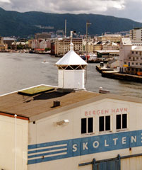
NO 655
[NO 188] |
Skoltegrunnskaien
This is the quay where North Sea ferries arrive from Lerwick, Scotland, and Newcastle, England, it is part of the historic port area of downtown Bergen. ferry (B 3831.4) [164800]
Photo courtesy Alex Trabas [liteslist] |
|
| NO 656 |
| Kvarven
latitude 60° 23' 57.6" N longitude 5° 14' 28.6" E
Located on a promontory on the south side of the Byfjørd about 4 km due west of the Bergen waterfront. There does not appear to be any land access to this site. (B 3822) [163200]
Photo courtesy Alex Trabas [liteslist] |
NO 657
[NO 190] |
Stongi
Looming above the light is the Sotraveien suspension bridge (highway 555) connecting Bergen to Sotra. The light is under the eastern end. (B 3818) [163000] ARLHS # NOR-414
Photo courtesy Alex Trabas [liteslist] |
|
NO 658
[NO 186E] |
Vatlestraumen |
Straumhellepynten, Vatlestraumen (B 3808) [162200] |
NO 659
[NO 186] |
Revskolten
latitude 60° 20' 11.9" N longitude 5° 10' 57.9" E |
Located in the Grimstadfjorden off the northern tip of Bjørøy, about 2.5 km northwest of the Bergen airport. [162100] |
| NO 662 |
Bogøy (Sjøforsvaret) |
St. Bogøy, Grimstadfjorden (B 3805) [161500] |
NO 667
[NO 185R] |
Raunane
latitude 60° 15' 49.9" N longitude 5° 10' 56.1" E |
Flatøy, Raunefjorden (B 3800) [160500] |
NO 669
[NO 185L] |
Børnestangen |
South of Klokkarvik, Korsfj. (B 3794) [160100] |
Bergen Lights facing the North Sea
NO 672
[NO 200C] |
Rubbegarnstangen (Rubbegarnståna)
latitude 60° 40' 28.8" N longitude 4° 47' 38.4" E |
North of Seløy (B 4124) [198000] |
NO 673
[NO 200] |
Svellingen
latitude 60° 39' 22.3" N longitude 4° 47' 12.8" E |
Located on a promontory at the entrance to the harbor of Hellesøy, near the northern end of Alvøy. (B 4122) [197600] ARLHS # NOR-296 |
NO 674
[NO 198H] |
Lakholmsund |
On the west coast of a small island west of Seløy (B 4118) [197000] |
NO 678
[NO 196S] |
Straumøytangen |
North of Oni in Hjeltefjord (B 4062) [185800] |
NO 680
[NO 198] |
Geitingen |
Located on a skerry in the North Sea about 3 km west of Tjeldstø. Accessible only by boat. (4106) [195000] ARLHS # NOR-016 |
NO 682
[NO 195] |
Rongesundet
latitude 60° 29' 20.8" N longitude 4° 55' 27.7" E |
The Rongsund is a passage between the Atlantic and the Hjeltefjord. Located on a point of land south of the highway 561 bridge on the west side of Bjørnøy. [191500] |
NO 684
[NO 191U] |
Skåragavlen
latitude 60° 27' 35.8" N longitude 4° 55' 20.8" E |
In Store Skarvøy southwest of Toftøyna (B 4093) [189400] |
NO 686
[NO 191T] |
Litla Turøyna
latitude 60° 26' 3.5" N longitude 4° 54' 24.2" E |
Northwest of Sotra (B 4092) [189200] |
NO 690
[NO 191A] |
Bleikskjeri |
Between Veløy and Langøy, Sotra (B 4084) [188300] |
NO 691
[NO 191] |
Hissøy |
The light is atop a cliff on Hissøy, a small island facing the North Sea on the west coast of Sotra. (B 4082) [188000] ARLHS # NOR 120 |
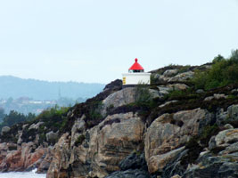
NO 695
[NO 185] |
Tekslo
latitude 60° 9' 17.4" N longitude 5° 23" E |
Located on a skerry on the north side of the entrance to the Korsfjord, directly opposite the Marstein lighthouse. This is the route to Bergen for larger vessels, so there should be a view of the lighthouse from North Sea ferries bound for that city. (B 3784) [159400] |
Southern Hordaland
| NO 702 |
Oldervik |
Samnangerfjorden (B 3712.6) [147000] |
| NO 703 |
Little Laugarøy
latitude 60° 8' 19.9" N longitude 5° 25' 39" E |
On the southern point of the same island that hosts Bleikja (above) (B 3736) [149900] |
| NO 704 |
Bleikja
latitude 60° 8' 21.4" N longitude 5° 25' 39.7" E
This is only one of numerous small lights of this type found on the fjords around Bergen. Located on the Bjørnafjord on the east side of the entrance to the harbor of Os. Accessible only by boat. (B 3735) [149700] ARLHS # NOR-397
Photo courtesy Alex Trabas [liteslist] |
|
| NO 705 |
Røtingtangen |
Røtinga, Bjørnafjorden (B 3734) [149500] |
| NO 706 |
Bakkasund |
Jorgefjorden, Spissøy NW Point (B 3776) [158700] |
| NO 707 |
Marstein
Located on a small island on the south side of the entrance to the Korsfjord. This is the route to Bergen for larger vessels, so there should be a view of the lighthouse from North Sea ferries bound for that city. (B 3780) [159000] ARLHS # NOR 031
Photo courtesy dietrovetro [Flickr] |
|
| NO 708 |
Stolmasund |
Stolmen, Selbjørnsfjorden (B 3757) [155900] |
| NO 709 |
Selbjørn |
Brosmevikpynten, south at Selbjørn (B 3758) [156000] |
| NO 710 |
Økshammaren (1875) |
This is what was called a "fishing light" because it was operated only during the local fishing season. Located at the eastern tip of the island of Selbjørn, across the Selbjørnsfjord from Slåtterøy lighthouse. [156000] |
| NO 711 |
Økshamaren (1918) |
Octagonal lantern mounted on a concrete pad at the top of a near-vertical cliff. Located near the historic lighthouse. (B 3760) [156400] ARLHS # NOR-286 |
| NO 712 |
Skor |
Southwest side of Tysnes, Langenuen (B 3726) [148700] |
| NO 713 |
Landrøypynten |
West side of Tysnesøy (B 3730) [149000] |
| NO 714 |
Rommelines |
Langenuen (B 3732) [149200] |
| NO 715 |
Presteskjær
Lille Presteskjær is a very charming lighthouse, situated in Rekefjord directly south of Hauge i Dalane. (B 3716) [147500] |
|
| NO 716 |
Malkenes |
Innerside of Bjørnafjorden (B 3714) [147400] |
| NO 717 |
Venjaneset |
Fusafjorden (B 3711) [146200] |
| NO 718 |
Lokksund Søre (South) |
Mosaknappen, Lokksundeten (B 3706) [145400] |
| NO 719 |
Lokksund Nordre (North) |
Vesletorva, Lokksundeten (B 3708) [145600] |
| NO 720 |
Hamarhaugflu |
Lokksund, Onarheimsfjorden (B 3704) [145200] |
| NO 721 |
Fjæreflu (Kvinnheradsfjorden) |
Located on the north side of the Kvinnheradsfjord (a section of the Hardangerfjorden), about 5 km northwest of Kvinnherad. photo (B 3674) [143300] |
| NO 722 |
Ænes |
Sildafjord (B 3678) [143700] |
| NO 723 |
Bondesund |
Øynefjorden (B 3675) [143600] |
| NO 725 |
Hamaren
latitude 60° 11' 29.2" N longitude 6° 5' 0.2" E |
At Hissfjorden in Hardangerfjorden (B 3680) [143800] |
| NO 726 |
Ljonestangen |
At Hissfjorden in Hardangerfjorden (B 3684) [143900] |
| NO 727 |
Jonanes
latitude 60° 17' 38" N longitude 6° 13' 20.5" E |
A White lantern (4 colored sectors) on a wooden structure at Samlafjorden in Hardangerfjord (B 3686) [144000] |
| NO 728 |
Kvamsøy |
Near the village Øystese located at the fjord Hardangerfjorden in Kvam municipality is an island called Kvamsøy, Ytre Samlen. Øystese (B 3688) [144200] |
| NO 730 |
Slåttenes |
At Eidfjord in Hardangerfjorden Photo (B 3692) [144600] |
| NO 731 |
Børvenes |
Sørfjorden (B 3696) [144800] |
| NO 732 |
Eitrheimsnes |
Odda, Sørfjorden (B 3700) [145100] |
| NO 733 |
Skorpen |
Skorpegavlen, Kvinheradfjorden (B 3672) [143200] |
| NO 734 |
Hågarnsnes |
West of Husnes in Husnesfjord (B 3671) [142800] |
| NO 735 |
Bjellandsøy |
North of Halsnøy (B 3668) [142500] |
| NO 736 |
Hillestadholmen |
Høylandssundet (B 3666) [142200] |
| NO 737 |
Mosnes |
In Åkrafjorden (B 3662) [141800] |
| NO 738 |
Skålnes |
Åkrafjorden (B 3660) [141700] |
| NO 739 |
Susodden |
Åkrafjorden (B 3658) [141600] |
| NO 740 |
Skånevik (Trøskenesflu) |
Trøskenesflu, Skåneviksfjorden (B 3656) [141400] |
| NO 741 |
Taraldsøy |
Brattholmen, Skåneviksfjorden (B 3654) [141300] |
| NO 742 |
Fjelbergsund |
Borgundo, Klosterfjorden (B 3652) [141100] |
| NO 743 |
Fjelbergsund Nordre (north) |
Borgundo, Klosterfjorden (B 3650) [141000] |
| NO 744 |
Kampareholmen |
A White lantern on a concrete base near Etnesundet, Ølsfjorden (B 3648) [140700] |
| NO 745 |
Grovaholmen |
East side of Stord, Langenuen (B 3724) [148500] |
| NO 746 |
Leirvik hamn Ytstøy |
Husøysnaget, Langenuen (B 3721) [148200] |
| NO 747 |
Stokkbleikjene
latitude 59° 47' 5.3" N longitude 5° 20' 4.4" E |
Southwest side of Stord (B 3740) [150600] |
| NO 748 |
Osparøy
latitude 59° 49' 3.4" N longitude 5° 17' 2.9" E |
Northwest side of Bømlos in Stokksund (B 3741) [150700] |
| NO 749 |
Brømenholmflu |
Northeast of Bømlo in Stokksund (B 3743) [151000] |
| NO 750 |
Eggøy |
Nyleid / Selbjørnsfjorden (B 3746) [151400] |
| NO 751 |
Stålhovo |
South of Slåtterøy (above) (B 3753) [153600] |
| NO 752 |
Slåtterøy
Located on a small island just off the larger island of Gisøy, marking the south side of the entrance to the Selbjørnsfjord. Accessible only by boat; there should be distant views from Gisøy, which is accessible at the end of highway 18 about 8 km northwest of Bømlo. (B 3752) [153500]
Photo courtesy Striljenta [Flickr] |
|
| NO 753 |
Selsøy |
East of Gisøyna (B 3750) [153300] |
| NO 755 |
Trettholmen |
West of Goddo (B 3634) [139800] |
| NO 756 |
Samnungsøy |
Bømlox northwest side (B 3624) [139200] |
| NO 757 |
Melandsvåg |
A White lantern near Arholmosen, Bømlo (B 3615) [136000] |
| NO 758 |
Hisken (Hiskehove) |
At Hiskehove, Bømlo west side (B 3614) [135700] |
| NO 759 |
Skotningen |
At Skotningen, west of Bømlo (B 3612) [135600] |
| NO 760 |
Lyngøyosen |
A lantern on a column located in Lyngøy, on the west side of Bømlos. (B 3610) [135501] |
| NO 761 |
Dyrnes |
Bømlos southwest side (B 3608) [135500] |
| NO 762 |
Dørøy |
Espevær (B 3604) [135100] |
| NO 763 |
Marholmen |
Espevær, Sletta (B 3602) [135000] |
| NO 764 |
Raudholmane |
Southwest of Bømlafjorden (B 3584) [133500] |
| NO 765 |
Bømlahamn
Located on a promontory on the east side of the entrance from the Bømlafjorden to Bømlahamn, at the south end of Midtøy. (B 3585) [133800]
Photo courtesy Robin Strand [Norphoto] |
|
| NO 766 |
Langevåg |
Lille Bleikja in Bømlafjord (B 3586) [134000] |
| NO 767 |
Mosterhamn |
Kaninholmen, Bømlafjord (B 3592) [134600] |
| NO 768 |
Ålfjord |
Nesjaneset, Ålfjorden (B 3644) [140400] |
| NO 769 |
Leirvik Hamn Midtøy |
Located on a promontory on the north side of the entrance to the harbor of Stord from the Husnesfjorden (a section of the Hardangerfjorden), about 3 km east of Stord. (B 3720) [148000] |
| NO 770 |
Førdespollen |
Located on the west side of the Førdespollen, an inlet on the south side of the Bømlafjorden, about 3 km northwest of Førde. (B 3636) [140000] |
| NO 771 |
Nappholmen |
Bømlafjord (B 3590) [134500] |
| NO 772 |
Håskru |
South in Bømlafjord (B 3580) [133400] |
| NO 773 |
Ryvarden
This lighthouse marks the southern entrance to the Bømlafjord and a network of passages leading far inland. However, the road to the lighthouse is gated, so visitors must be prepared to hike 2 km or call for special permission to bring their cars to the site. Located about 8 km west of Sveio and 3 km off the pavement of highway 541. (B 3578) [133200] ARLHS # NOR-038
Photo courtesy Ronald Woehrn [liteslist] |
|
| NO 774 |
Mølstrevågen |
Laksnotholmen / Mølstrevåg. (B 3576) [133100] |
|
|
 West Norway

