|
This page shows the Lighthouses of the Isle Mann. You can click on the photo of the light to go to it's specific (larger resolution) copy. Each lighthouse name is linked to (in our editorial opinion) the best reference site for that light. There has been significant usage of the Lighthouse Directory prepared by Russ Rowlett (UNC). My thanks to him for providing this basis for understanding. LHdirectory |
|
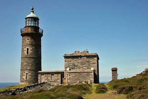
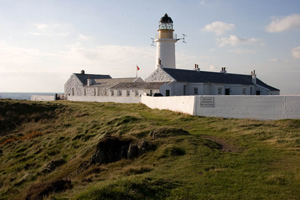
| IM 1 |
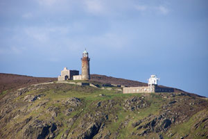
Point of Ayre High
latitude 54° 24' 56.8" N longitude 4° 22' 5.1" W
Northern tip of Isle of Man near the end of A16. The surrounding area is private land. (A 4720) ARLHS # IOM-013
Photo courtesy A. Hisgett [Flickr] |
|
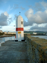
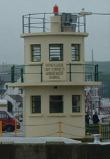
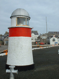
| IM 2 |
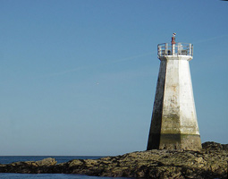
| Point of Ayre Low (Winkie)
latitude 54° 25' 1.9" N longitude 4° 21' 49.8" W
The cast iron tower was placed at the edge of the sea about 225 m from the main light. In 1950, a concrete tower was built another 230 m seaward, and the historic tower was relocated atop the new tower. Located on the beach at the northeastern point of the island, beyond the end of the A16 highway. ARLHS # IOM-021
Photo courtesy Lloyd Kinley |
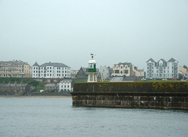
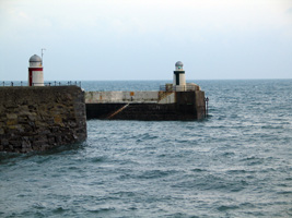
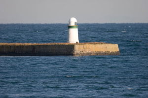
| IM 3 |
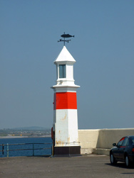
Peel Pierhead
latitude 54° 13' 32.2" N longitude 4° 41' 50.7" W
Located at the end of the pier on the east side of the entrance to Peel's inner harbor. (A 4730) ARLHS # IOM-027
Photo courtesy Alex Trabas [liteslist] |
|
| IM 4 |
| Peel Castle Jetty
latitude 54° 13' 34.8" N longitude 4° 41' 49.8" W
Located at the end of a stone jetty at the southeastern corner of St. Patrick's Isle, marking the west side of the entrance to Peel's inner harbor. (A 4732) ARLHS # IOM-012
Photo courtesy I. Watkins [Flickr] |
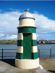
| IM 5 |
Peel Breakwater
latitude 54° 13' 40.8" N longitude 4° 41' 41.2" W
The lighthouse is located at the end of a stone breakwater extending northeastward from St. Patrick's Isle. (A 4735) ARLHS # IOM-020
Photo courtesy Allen Mason [Flickr] |
|
| IM 6 |
| Port Erin Range Front
latitude 54° 5' 14.1" N longitude 4° 45' 33.9" W
The rear light is on a streetlight-style pole. Located on the waterfront in Port Erin, at the southwestern corner of the island. rear (A 4740) ARLHS # IOM-014
Photo courtesy Tasa M [Flickr] |
| IM 7 |
Raglin Pier
latitude 54° 5' 7.2" N longitude 4° 45' 51.3" W
Located at the end of a stone pier on the waterfront in Port Erin. (A 4744) ARLHS # IOM-022
Photo courtesy Alex Trabas [liteslist] |
|
| IM 8 |
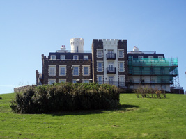
| Douglas Head (1811) (Herring Tower)
latitude 54° 8' 36" N longitude 4° 28' 2.5" W
In 1869 this tower was incorporated into the Douglas Head Hotel. The hotel was demolished in 1999, but the tower was retained. The site is now occupied by apartments. Located high atop Douglas Head just southwest of Douglas, the capital of the island. |
|
|
| IM 9 |
Douglas Head (1892)
latitude 54° 8' 36.1" N longitude 4° 27' 57" W
SE point of Isle of Man (A 4770) ARLHS # IOM-008
Photo courtesy Geoff Coupe [Flickr] |
|
| IM 10 |
| Battery Pier
latitude 54° 8' 46.9" N longitude 4° 27' 58" W
Located at the end of a pier on the east side of Douglas Harbour (A 4722)
Photo courtesy Fred Fox [ListOfLights] |
| IM 11 |
Laxey Pier
latitude 54° 13' 28.9" N longitude 4° 23' 20.3" W
Sibling of the Castle Jetty Light at Peel. Located at the end of the pier at Laxey, about 10 km northeast of Douglas IM4 (A 4784) ARLHS # IOM-019 |
|
| IM 12 |
Laxey Breakwater
latitude 54° 13' 27.4" N longitude 4° 23' 16.9" W |
Located at the end of the breakwater at Laxey.(see above) (A 4785) ARLHS # IOM-013
Photo courtesy Fred Nuff [Flickr] |
| IM 13 |
Maughold Head
latitude 54° 17' 44.6" N longitude 4° 18' 33.7" W
Located on a sharp cape about 6 km east of Ramsey. Site and tower closed, but there are good views from the road above the lighthouse. (A 4786) ARLHS # IOM-010
Photo courtesy John Veitch [Flickr] |
|
| IM 14 |
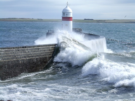
| Ramsey South Pier
latitude 54° 19' 25.5" N longitude 4° 22' 30" W
Located at the end of the northern of two parallel piers at the entrance to Ramsey Harbour. South is the light in the foreground. (A 4796) ARLHS # IOM-015 |
|
|
| IM 15 |
Ramsey North Pier
latitude 54° 19' 27.7" N longitude 4° 22' 29.9" W |
See picture above. (A 4798) ARLHS # IOM-024
Photo courtesy Tasa M. [Flickr] |
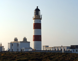
| IM 16 |
Chicken Rock
This wave swept tower was built on a submerged reef. (A 4748) ARLHS # IOM-003
Photo courtesy Calum MacAulay [Flickr] |
|
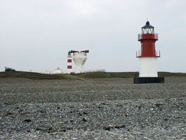
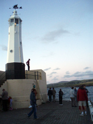
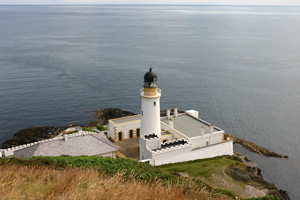
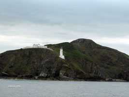
| IM 17 |
| Calf of Man (1968)
latitude 54° 3' 11.8" N longitude 4° 49' 44.9" W
This was the last light built in Scotland (1968). It was automated in 1995. The new light is to the right, old one is to the left.
Southwest tip of the Isle of Man. ARLHS # IOM-001
Photo courtesy Calum MacAulay [Flickr] |
| IM 18 |
Calf of Man (1818) Low
latitude 54° 3' 9" N longitude 4° 49' 43.9" W |
Located near the southern end of the island, facing Chicken Rock ARLHS # IOM-031 |
| IM 20 |
| Thousla Rock
latitude 54° 3' 43.8" N longitude 4° 48' 2.6" W
Located on a rock in the channel separating Isle of Man and Calf of Man. (A 4745) ARLHS # IOM-025
Photo courtesy Alex Trabas [liteslist] |
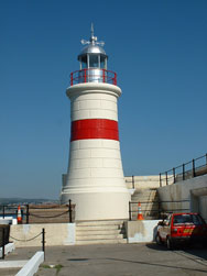
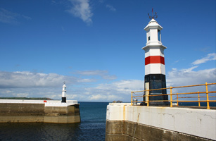
| IM 21 |
Alfred Pier
latitude 54° 4' 19.7" N longitude 4° 43' 49.3" W
Located at the end of the inner pier of Port St. Mary. Notice it is very similar to Ramsey, (but still not a clone.) IM14
On January 11, 2009, this light was washed away. Stay tuned for more data. (A 4754) ARLHS # IOM-026
Photo courtesy Alex Trabas [liteslist] |
|
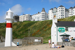
| IM 23 |
Castletown New Pier
latitude 54° 4' 19.7" N longitude 4° 38' 57.4" W
Located at the end of the pier in Castletown. (A 4760) ARLHS # IOM-032
Photo courtesy Paul Dyer [Flickr] |
|
| IM 24 |
| Irish Quay
latitude 54° 4' 22" N longitude 4° 39' 0.8" W
Located at the end of Irish Quay in Castletown. (A 4761) ARLHS # IOM-017
Photo courtesy Alex Trabas [liteslist] |
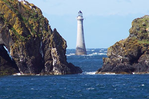
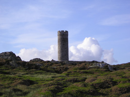
| IM 25 |
Langness (1811) (Herring Tower)
latitude 54° 3' 15.3" N longitude 4° 37' 27.4" W
This tower and an identical tower at Douglas Head were built as daybeacons years before the Isle of Man had any proper lighthouses. The towers are copies of a round tower at Peel Castle. Located about 200 m south of Langness Light (below.) tower
Photo courtesy James [Flickr] |
|
| IM 26 |
| Langness (1880)
latitude 54° 3' 17.3" N longitude 4° 37' 30.3" W
Located on the east side of Dreswick Point, the southern point of the peninsula, about 2.5 km south of Derbyhaven. (A 4762) ARLHS # IOM-009
Photo courtesy Mike Caine [Flickr] |
| IM 27 |
Derbyhaven
latitude 54° 4' 34.7" N longitude 4° 37' 3.2" W
Located at the end of the detached breakwater in Derbyhaven, accessible with caution at low tide by walking across the exposed beach to the breakwater.
Photo courtesy Mike Caine [Flickr] |
|
|
|