|
This page shows the Lighthouses of Hawaii. I have not personally visited any of these lights, so your input is appreciated. Each lighthouse is linked to (in our editorial opinion) the best reference site for that light. Index data (on the left below) comes from Bob and Sandra Shanklin. p2 I am very grateful to Lighthouse Friends for their excellent data on location and directions to lights. friends |
|
| HI 1 |
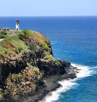
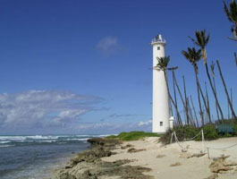
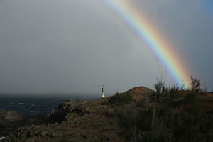
Kilauea
access: car
Follow Highway 56 to the northern shore of Kaua`i and the town of Kilauea. In Kilauea, turn right onto Kolo Road and then take a quick left onto Kilauea Road ARLHS # HAW-004
Photo courtesy KelliMays [webshots] |
|
| HI 1C |
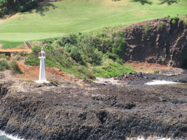
| Kuki'i Point
The Kuki'i Point Light was originally powered by acetylene gas and was maintained by the keeper of the Nawiliwili Lighthouse.
From Highway 51 (Rice Street) near the northern end of Nawiliwili Bay, turn west on Hoolaulea Way (this is the road to Kaua'i Marriott Resort and Kauai Lagoons Golf Club). Drive past the Marriott and then turn right onto Kalapaki Circle. Continue until the end of the road, where you will find public parking and a public path to the shore and the light. ARLHS # HAW-037
Photo courtesy Ennazus58 [Flickr] |
| HI 1J |
Ahukini Breakwater (historical)
latitude 21° 57' 11.7" N longitude 159° 20' 55" W |
Nearest Town or City: Lihue Hawaii, on the island of Kaua'i.
Location: Hanama'ulu Bay, Kaua'i. ARLHS # HAW-029 |
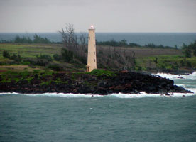
| HI 1M |
Makahu'ena Point (historical)
latitude 21° 52' 7.6" N longitude 159° 26' 40.2" W
access: car
The Inter-Island Steam Navigation Company maintained a red light at Koloa Point, the southernmost point on Kaua'i, around the turn of the nineteenth century, but the aid was only displayed when one of the company's vessels was expected. The Lighthouse Board established an official navigational aid at Koloa Point in 1908.
From Lihue, take Highway 50 east and then turn south on Highway 520 (Maluhia Road). Follow Highway 520 south for 3.4 miles. The highway will turn right and become Koloa Road in Koloa. After just a short distance on Kolo Road turn left and continue south on Highway 520 (Poipu Road.) After three miles, turn right onto Pee Road and follow it until you see a vacant lot on your left. The light is at the end of the lot. ARLHS # HAW-038
Photo courtesy Derek Mendez [Flickr] |
|
| HI 2 |
| Nawiliwili Harbor
latitude 21° 57' 17.7" N longitude 159° 20' 9.8" W
access: car
Starting from the Lihue airport, take Highway 570 to Highway 51. Turn left on Highway 51 and after 0.4 miles turn left into an entrance with a gatehouse. Just tell the guard you want to visit the lighthouse and follow the road as it skirts the airport runway, cuts through a golf course and leads you to the base of the lighthouse. ARLHS # HAW-007
Photo courtesy © 2002 Mark Brady [Flickr] |
| HI 2K |
Ka'ena Point
latitude 21° 34' 27.6" N longitude 158° 16' 45.7" W |
Ka'ena Point is the westernmost tip of O'ahu and is a celebrated legendary site for the Hawaiian people. The Ka'ena Point Natural Reserve Area was created in 1983 to help protect the fragile dunes and native species on the point. Making the area immediately around the point off-limits to dogs and vehicles has helped restore the natural landscape and elevate the number of nesting Laysan albatross and wedge-tailed shearwaters.
From H1 in Honolulu, travel west and then follow H2 north until it ends. Continue on Highway 99 for two miles, and then continue north on 803 towards Waialua. When the road splits into Highway 930, take the western branch, the Farrington Highway, and follow it past Dillingham Airfield to its end. You will then need to hike in about 2.5 miles. ARLHS # HAW-017 |
| HI 3 |
Barber's Point
latitude 21° 17' 46.5" N longitude 158° 6' 19.7" W
access: car
From Honolulu, take H1 west to Exit 1 (Campbell Industrial Park). Take Exit 1, which loops back over the highway, and proceed south on Kalaeola Boulevard until it ends at Olai Street. Turn right on Olai Street which leads to the lighthouse. ARLHS # HAW-001
Photo courtesy barsphotos [webshots] |
|
| HI 3C |
Pearl Harbor (historical) |
ARLHS # HAW-033 |
| HI 3H |
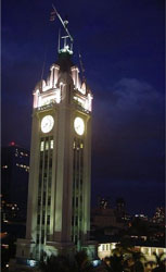
Honolulu Harbor (Aloha tower)
latitude 21° 18' 25.6" N longitude 157° 51' 57.8" W
A large-scale project provided a modern freight and passenger terminal at piers 8, 9, and 10 in Honolulu Harbor. As part of this project, a tower was constructed to provide offices for the harbor master, pilots, and customs officials.
Take the Nimitz Highway (92) to downtown Honolulu and turn towards the waterfront on Bishop Street. There is parking in the area, and the Hawaii Maritime Center is next door at Pier 7. Maritime center ARLHS # HAW-014
Photo courtesy Gerald Farinas [Wikipedia] |
|
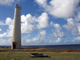
| HI 4 |
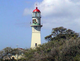
| Diamond Head
latitude 21° 15' 20.6" N longitude 157° 48' 34.2" W
access: car
From H1 near Waikiki, exit onto University Avenue and go towards the ocean. Turn left onto Date Street then right onto Kapahulu Avenue and follow it to Paki Avenue. Turn left on Paki Avenue, which will become Diamond Head Road as you near the foot of the volcano. The lighthouse will be on your right-hand side as you round the base of the volcano. ARLHS # HAW-003
Photo courtesy fotofabian [webshots] |
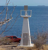
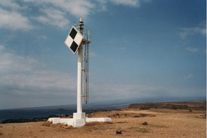
| HI 4P |
Pyramid Rock
latitude 21° 27' 44.3" N longitude 157° 45' 48.6" W
access: none
The Pyramid Rock Light currently consists of a light mounted on the roof of a square concrete workhouse, painted with distinctive black and white diagonal stripes. The light guides vessels into Kane'ohe Bay and overlooks a recreational beach for the marines.
Visitor Access is restricted to military personnel ARLHS # HAW-027
Photo courtesy marinas.com [marinas.com] |
|
|
|
| HI 5 |
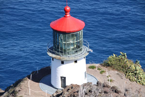
| Makapu'u
access: car + walk (1.3 mile) + view
From Honolulu, take H1 east. H1 will become Highway 72 just past Diamond Head. Follow Highway 72 around the island for several miles passing Hanauma Bay and Sandy Beach. Just over a half mile past the Hawaii Kai Golf Course, there is a gated dirt road on your right. This is the start of the 1.3 mile hike to the top of Makapu`u Head from which you can view the lighthouse. If you continue along Highway 72 for about a mile, you can get a distant view of the lighthouse without taking the hike. ARLHS # HAW-005
Photo courtesy Michael J Matusinec [Flickr] |
| HI 6 |
Molokai (Kalaupapa)
access: mule tour
The Kalaupapa Peninsula can be reached via foot, mule or airplane. Mule rides are available from Molokai Mule Ride mules
The cheapest airfare we found for a flight from Honolulu to Molokai, and then down to the Kalaupapa Peninsula was with the Molokai Air Shuttle (808) 567-6847. No matter how you reach the peninsula, you must by law be signed up for a tour. If you take the mule ride adventure, a tour with Damien Tours is part of the package. ARLHS # HAW-006
Photo courtesy loxey [webshots] |
|
| HI 6C |
Kaunakakai Range (Front) |
Maui County has established a Kaunakakai Lighthouse Park with picnic tables. The rear range light is a similar 38-foot skeletal tower about 500 feet from the front range light
Location: Kaunakakai Harbor, south side of Molokai. ARLHS # HAW-028 |
| HI 6L |
La'au Point (Lae O Ha Laau Point) Hist - |
Location: SW end of Molokai Island, Hawaii ARLHS # HAW-032 |
| HI 6P |
Palaoa Point (Cape Ka'ea) |
From Highway 400, just west of the airport, turn south on Kaupili Road - there is a stone marker at the turnoff that reads Kaunolu, but it might be hard to see. Travel 2.1 miles on Kaupili Road and then turn right onto another dirt road, which is also marked by a stone inscribed with Kaunolu. Follow this road, which will become quite rocky and steep, for 2.8 miles to the coast. If you rent a jeep at the airport, it's not allowed on these roads. ARLHS # HAW-021 |
| HI 6R |
Manele Bay |
Located at the end of the breakwater in the harbor at Manele Bay on the southern shore of Lana'i. A good way to see Manele Bay Light is aboard Expeditions Maui-Lana'i Ferry that operates daily between the two islands. ferry
You can reach the light by taking Highway 440 (Manele Road) to the southern end of the island. |
| HI 6V |
Pohakuloa Point |
Located on the northern shore of Lana'i.
You can hike six miles west from the parking area at Shipwreck Beach or attempt to drive closer to the light. If you drive to Garden of the Gods near the western end of the island, you will find a dirt road named Awalua that leads downward to the northern shore of Lana'i, ending a mile or so from the light. |
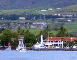
| HI 7 |
Lahaina
access: car + view
From Kahului, take Highway 380 to Highway 30. Follow Highway 30 around the western lobe of Maui to Lahaina. In Lahaina, turn left onto Prison Street and then right onto Front Street. The lighthouse is at the western end of the harbor to your left, behind the Pioneer Inn. inn ARLHS # HAW-020
Photo courtesy v2cib226 [webshots] |
|
| HI 7A |
| McGregor Point
access: car
McGregor Point is located off Honoapiilani Highway (Highway 30), just west of Ma`alaea on the way to Lahaina between Mile Markers #7 and 8 ARLHS # HAW-025
Photo courtesy Maria*PA [Flickr] |
| HI 7C |
Pa'uwela Point (New)
latitude 20° 56' 45.1" N longitude 156° 19' 15.9" W |
Located on Pa'uwela Point, the northernmost point on Maui's eastern lobe
From Wailuku/Kahului proceed east on Highway 36 towards the town of Pa'uwela. After you pass mile marker 11 look for the Haiku Community Center. The road that leads to Pa'uwela Point Light is across the road from the center. As this road may not be passable, you may need to park near the community center and walk a little over a mile to the light. ARLHS # HAW-036 |
|
|
| HI 7D |
Pa'uwela Point (Old) |
May be nothing but ruins at this time ARLHS # HAW-015 |
| HI 7J |
Nakalele Point (historical)
latitude 21° 1' 44.5" N longitude 156° 35' 26" W
access: car + walk
Located on the northern tip of Maui's western lobe.
From Lahaina, travel north on Highway 30 for 15.7 miles were you will find a pullout just past mile marker 38. The Nakalele Light is located down the hill from the pullout by the shore. ARLHS # HAW-039
Photo courtesy Paul & Kelly [Flickr] |
|
| HI 7K |
Ka'uiki Head
latitude 20° 45' 25.2" N longitude 155° 58' 47.3" W |
Hana (Pueokahi) Bay has a diameter of about 3/8 mile and is defined by Nanualele Point on the north and Ka’uiki Head on the south. The light is located on the tiny islet of Pu'uki'i just off Ka'uiki Head on the southern side of Hana Bay. ARLHS # HAW-018 |
| HI 7M |
Hanamanioa Point
latitude 20° 34' 59.4" N longitude 156° 24' 43.2" W |
Over the years, several lights have marked Maui’s southernmost point, which surrounds La Perouse Bay and is known as Cape Hanamanioa.
Take the Road to Hana (Highway 360) to the eastern shore of Maui, and then turn east onto Keawa Place, which will take you to Hana Beach Park. Park near the pier, and then follow a trail along the shore out to Ka'uiki Head from where you can get a view of the light on Pu'uki'i Island. The island is a bird sanctuary and is off-limits. ARLHS # HAW-030 |
| HI 7N |
Kealakekua Bay (Napo'Opo'O) |
No data is available other than the ARLHS listing. ARLHS # HAW-024 |
| HI 7P |
Keahole Point |
A light was placed at Keahole Point, the westernmost point on the Big Island, around 1908. Although the airport's aerobeacon can be seen farther offshore than the Keahole Point Light, the Keahole Light still serves the important role of marking the western extreme of the island of Hawai'i. photo
From the Keahole-Kona International Airport, drive south for just over a mile on Highway 19 and then turn west onto Otec Road, which leads to the Natural Energy Laboratory of Hawaii Authority and Wawaloli Beach. Follow the road past Wawaloli Beach to its end, where you will find the light. Energy Lab ARLHS # HAW-019 |
| HI 7Q |
Kailua Point |
The light sits on Kuka'ilimoku Point and marks the northwestern side of Kailua Bay, which is home to a sport fishing fleet.
From Highway 19 at the northern end of Kona, turn towards the ocean on Palani Road. After 0.4 miles, turn right on Kuakini Highway. After you pass Kaiwi Street/Kona Bay Drive, turn left into the athletic complex and park near the outfield of the easternmost ball field. Walk south along the outfield fence, and you will find a gate for public access to the shoreline in front of the gated housing community. ARLHS # HAW-009 |
| HI 7S |
Milolii |
This is the location of a fishing village without power or water. More is not known ARLHS # HAW-013 |
| HI 7T |
Makahanaloa (Old) (historical) |
ARLHS # HAW-035 |
| HI 7V |
Mahukona
latitude 20° 10' 58.5" N longitude 155° 54' 2.8" W |
Located just south of Mahukona Beach Park. This site was first used as a winter loading spot for sugar cane (as the weather on the other side was so terrible.)
Take Highway 270 towards the northern end of the island. Six miles before the tip of the island you will find Mahukona Beach Park Road towards the west. Follow this road as far south as you can, park, and then follow the trail that goes south along the shore to the light. ARLHS # HAW-012 |
| HI 7X |
Kawaihae Bay |
Kawaihae (by 1845) had become an important stop for procuring fresh food and beef. Cattle were also being shipped from Kawaihae, located on the northwest coast, to supply the whaling needs at Honolulu and Lahaina.
From the junction of Highways 19 and 270 on the western shore of the Big Island, proceed north on Highway 270 for 1.8 miles, passing the Kawaihai Small Boat Harbor, and you will see the light on your left. ARLHS # HAW-011 |
| HI 8 |
Kauhola Point
access: car + walk (1 mile)
From the intersection of Highway 250 and 270 in Hawi, near the northernmost point on the big island, proceed east on Highway 270 (Akoni Pule Highway). After roughly two miles, turn left on Halaula Road. As you drive towards the ocean the road will become progressively worse. You will likely need a four-wheel drive vehicle to get to the lighthouse, but you can park and walk the last mile or so. ARLHS # HAW-010
Photo courtesy Voodo Zebra [Flickr] |
|
| HI 8F |
Kukuihaele |
The Kukuihaele Landing, located on the northeastern side of the island just south of the Waipio Valley, was one of nine wire landings established along the windward shore. To mark the landing, the present thirty-four-foot concrete tower was built in 1937. Due to the height of the bluff on which it stands, the light has a focal plane of 154 feet. The Kukuihaele Light is the only remaining concrete light structure in Hawai'i which has an interior ladder used for accessing the lamp.
The roads which lead to this light are gated as the surrounding land is no longer planted in sugar cane but is used to pasture cattle. ARLHS # HAW-031 |
| HI 8L |
Laupahoehoe Point (historical) |
Laupahoehoe means "lava leaf" or "smooth lava flat" and is an apt description of this small peninsula that was formed when lava flowed down a valley and formed a delta extending several hundred feet into the ocean. In 1890, the first light was built on Laupahoehoe Point, the outermost tip of the peninsula.
Take Highway 19 along the Big Island's eastern shore to mile marker 27. Turn onto Laupahoehoe Point drive, and follow it down to the ocean and Laupahoehoe Point Park. The light is located near the easternmost point in the park. Don't confuse the light near the boat ramp and breakwater with the real Laupahoehoe Point Light. ARLHS # HAW-026 |
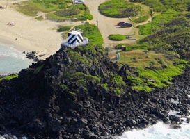
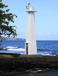
| HI 8P |
Coconut Point (Hilo Harbor)
latitude 19° 43' 36.8" N longitude 155° 5' 10.4" W
Located along the shoreline of Hilo Bay at the Intersection of Highway 19 and Waianuenue Avenue in Hilo. photo ARLHS # HAW-023
Photo courtesy Michael J Matusinec [Flickr] |
|
| HI 8Q |
Pauka'a |
To mark Hilo Bay, the first one selected was on the shore at Pauka’a, two and a half miles north of Hilo. Mariners could steer directly towards the light, and then sail south to enter the bay.
This light is surrounded by houses and only glimpses of it can be had from public land. ARLHS # HAW-022 |
| HI 8R |
Pepeekeo Point (Aila Point, Makahanaloa) |
Alia Point lies just under nine miles north of Hilo on the eastern coast of the Island of Hawai'i. ARLHS # HAW-016 |
| HI 8V |
Kalae (South Point)
latitude 18° 54' 44.1" N longitude 155° 40' 54.9" W
access: car
Located on Ka Lae or South Point, the southernmost point of the Big Island. ARLHS # HAW-008
Photo courtesy Alex Vosicka [Flickr] |
|
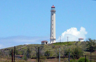
| HI 9 |
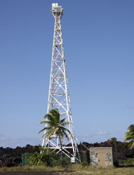
| Cape Kumukahi (tall skeleton tower)
latitude 19° 30' 57.8" N longitude 154° 48' 39" W
access: car
From Hilo, take Highway 11 south to Highway 130. Follow Highway 130 for just under 12 miles then turn left onto Kapoho Road. After 2.7 miles on Kapoho Road you will pass Lava Tree State Park on your left. The road takes a sharp turn to the left just after this interesting park, and the lighthouse is 6.8 miles farther down the road. Before reaching the lighthouse, the road becomes dirt and is quite rough. ARLHS # HAW-002
Photo courtesy Michael J Matusinec [Flickr] |
|
|
If you have more information about these lights, or this region, contact me and well discuss arrangements. mailMe

