 Hawaii
 Oregon
| Home | Google Map | Hawaii |
Mexico |
| Alaska | British Columbia | Washington | Oregon |
|
This page currently shows the Lighthouses of California. Each lighthouse is linked to (in our editorial opinion) the best reference site for that light. Copies of my pictures are stored on the Webshots site if you want to download them. Flickr I am very grateful to Lighthouse Friends for their excellent data on location and directions to lights. friends In addition, the pictures below are linked to the relevant photo on the web (thus making available to you a higher resolution picture.) Index data (on the left below) comes from List of ALL Existing U.S. Lighthouses by Bob and Sandra Shanklin. p2 |
 Custom Search
|
If you would like copies of any of my pictures, contact me and we'll discuss arrangements. There are others who do this commercially, I have no intention of competing directly, but you can make a proposal, and I'll react. mailMe
| Home | Google Map | Hawaii |
Mexico |
| Alaska | British Columbia | Washington | Oregon |
| CA 1 |
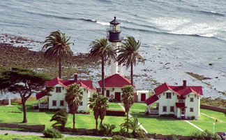
Point Loma latitude 32° 39' 54.5" N longitude 117° 14' 33.6" W access: car From I-5 South or I-8 West, take the exit for Rosecrans Street, also known as Highway 209. Stay on Rosecrans into Point Loma, and then turn right onto Canon Street. Take a left onto Catalina Boulevard and follow it to Cabrillo National Monument * (G 3676) Photo courtesy François Le Poutré |
|
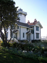
| CA 2 |
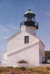
| Old Point Loma latitude 32° 40' 19.1" N longitude 117° 14' 27.5" W access: car See directions above. The Old Point Loma Lighthouse is open the same hours as the monument, and there is a museum adjacent to the lighthouse in a replica of the assistant keeper's dwelling. Photo courtesy Savannah Grandfather [Flickr] |
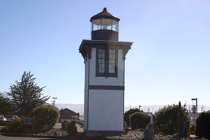
| CA 2P |
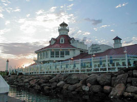
Parker's Lighthouse access: car Renovated 1998-99. Located in Shoreline Village on the east side of the small boat basin, opposite the Long Beach Lions Light. Photo courtesy epicr [webshots] |
|
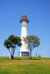
| CA 3 |
| Long Beach Harbor latitude 33° 43' 23.7" N longitude 118° 11' 12.6" W access: boat Various vessels in Long Beach's Rainbow Harbor offer harbor cruises that may pass by the Long Beach Harbor Lighthouse. harbor The best point from which to view the light from land, and admittedly this view isn't all that great, is at the end of Pier F in Long Beach Harbor. To reach Pier F, take Interstate 710 to downtown Long Beach and follow the spur which goes over the harbor and to the Queen Mary. Once you cross over the harbor, look for signs, which will guide you to Pier F. Photo courtesy Robert English [Flickr] |
| CA 3A |
Long Beach Shoreline Park latitude 33° 45' 36.7" N longitude 118° 11' 38.6" W access: car On the edge of the Los Angeles River right next to the Queensway Bay bridge. This looks like an intentional "tourist attraction", not a real lighthouse. Photo courtesy Jamie Olivares [Flickr] |
|
| CA 4 |
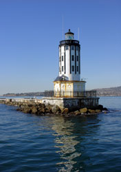
| Los Angeles Harbor (Angel's Gate) latitude 33° 42' 30.8" N longitude 118° 15' 5.7" W access: car + walk From the southern terminus of Interstate 110, proceed south on Gaffey street roughly 1.5 miles to 21st street. Turn left on 21 street, and then right on Pacific Avenue. After one mile, turn left on Stephen M White Drive and stay left to continue into Cabrillo Beach Park, where you can park and walk the breakwater to the lighthouse. Photo courtesy cybele-la [Flickr] |
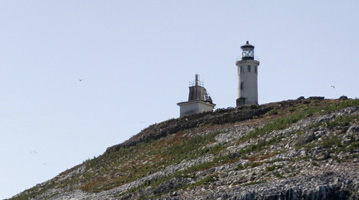
| CA 5 |
Point Fermin latitude 33° 42' 19.6" N longitude 118° 17' 37.4" W May 10, 2022 access: car The point Fermin Lighthouse, was built in 1874, and is on the National Register of Historic Places. Currently it is owned by the City of Los Angeles and administered by the Department of Recreation and Parks From the southern terminus of Interstate 110, proceed south roughly three miles on Gaffey Street which ends at Point Fermin Park. |
|
| CA 6 |
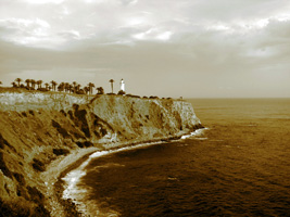
| Point Vicente latitude 33° 44' 30.7" N longitude 118° 24' 34.9" W May 10, 2022 access: car From the southern end of Interstate 110, follow Gaffey Street south through San Pedro roughly 2 miles to 25th Street. Turn right on 25th street. Follow 25th Street 2.7 miles until it turns into Palos Verdes Drive. The lighthouse is located at 31550 Palos Verdes Drive West, which is roughly 4.5 miles from the point where 25th Street become Palos Verdes Drive. |
| CA 7 |
Point Hueneme latitude 34° 8' 42.6" N longitude 119° 12' 36" W access: car From Highway 101 north of Los Angeles, take Highway 1 towards Oxnard and Port Hueneme. Exit onto Saviers Road (Highway 34) and drive south just under three miles to its end. Turn right onto Hueneme Road, go one mile and then turn left onto Ventura Road. When Ventura Road ends, turn right onto Surfside Drive. Park along the street and follow the coast north on foot about 1/2 mile to the lighthouse. Photo courtesy Taylor [wikipedia] |

|
| CA 8 |
| Anacapa Island latitude 34° 57.2" N longitude 119° 21' 33.9" W access: boat Island Packers, operating out of Channel Islands Harbor in Oxnard, is an authorized concessionarie to Anacapa Island. IslandPackers Photo courtesy Kance [Flickr] |
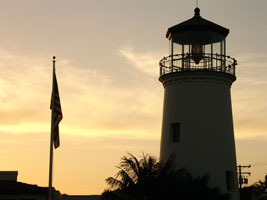
| CA 9 |
Santa Barbara latitude 34° 23' 49.3" N longitude 119° 43' 19.2" W access: car From Highway 101 in Santa Barbara, take the Carrillo Street exit and go west towards the ocean. Near the summit of the hill, Carrillo Street turns into Meigs Road. Follow Meigs Road towards the ocean until you see Lighthouse Place on your right. Please note this is an active Coast Guard station. Photo courtesy yblue [Flickr] |
|
| CA 10 | 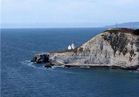
| Point Conception access: none This is private land and the closest approach is 5 miles from the lighthouse. Photo courtesy omaatje9 [webshots] |
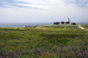
| CA 11 |
Port St. Luis latitude 35° 9' 37.5" N longitude 120° 45' 39.9" W access: walk (3.5 mile) The lighthouse can currently be visited by signing up for a docent-led hike along the Pecho Coast Trail. The half-day, 3.5-mile hike to the lighthouse offers a spectacular view of San Luis Obispo Bay. To listen to the current listing of scheduled hikes and to make reservations, call (805) 541-TREK. Photo courtesy Wolfgangkaml [wikipedia] |

|
| CA 12 |
| Piedras Blancas latitude 35° 39' 56.2" N longitude 121° 17' 4" W access: car + walk (1/2 mile) From the turnoff to Hearst's Castle on Highway 1, proceed 5.7 miles north to a locked gate, from which a road leads 0.4 miles to the lighthouse. For information on public tours of the lighthouse, call (805) 927-6811. tours Photo courtesy Mark Gibson [Flickr] |
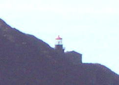
| CA 13 |
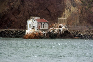
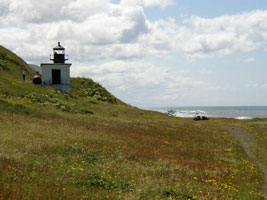
Point Sur latitude 36° 18' 22.8" N longitude 121° 54' 5.6" W access: tour (walk) If you really want to see this light, come on a Saturday or a Sunday. Otherwise, you get this "long view" (G 3988) |
|
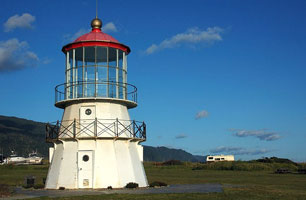
| CA 14 |
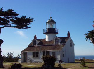
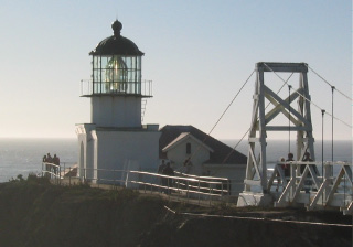
| Point Pinos latitude 36° 38' 0.2" N longitude 121° 56' 1.2" W November 14, 2002 access: car + view Like most of the California Lighthouses, this is a low slung (no height for an earthquake to attack) light. It's right next to a a golf course, so easy to spot from a long way (on the ground). (G 3992) |
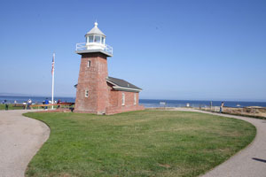
| CA 15 |
Abbott Memorial Lighthouse , Santa Cruz access: car From Highway 1 in Santa Cruz, go south on Bay Street until it ends at West Cliff Drive. Turn right on West Cliff Drive and proceed for almost a mile to the lighthouse. Photo courtesy AE Fitzhugh [Flickr] |
|
| CA 15B | 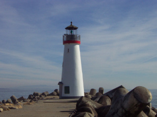
| Walton (Santa Cruz Breakwater) latitude 36° 57' 38.4" N longitude 122° 7.9" W November 16, 2002 access: car This is a brand new light (built in 2001), probably built for Tourist Attraction purposes. |
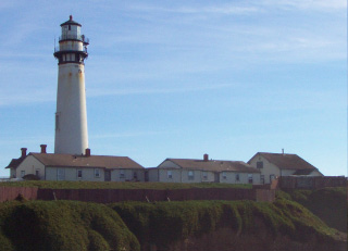
| CA 16 |
Pigeon Point latitude 37° 10' 54.3" N longitude 122° 23' 38.7" W November 16, 2002 access: car Probably the most photographed lighthouse in California, Pigeon Point clearly is a very nice looking lighthouse. It currently is a hostel, so not always available for walking tours. (26 miles north of Santa Cruz or 20 miles south of Half Moon Bay. Clearly visible from Highway 1, the lighthouse is reached by a short drive down Pigeon Point Road) (G 4006) |
|
| CA 17 |
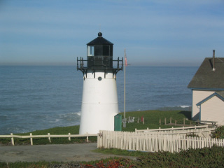
| Point Montara latitude 37° 32' 11.4" N longitude 122° 31' 9.5" W November 18, 2002 access: car Once again, this is now private land. I arrived there early and was able to get these pictures, but for most of the day, the access is very limited. |
| CA 18 |
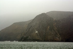
Miles Rock latitude 37° 47' 33.7" N longitude 122° 30' 36" W July 28, 2007 access: car + walk By late afternoon, we had good weather, and got this picture from Point Bonita. CA 26 A closer view can be had by taking Lincoln Boulevard, the first Highway 101 exit south of the Golden Gate Bridge, and heading west. The road will become El Camino Del Mar, which you can follow to the area around Lincoln Park. You park and hike down to the bluffs above the water to get a better view of the light. Otherwise, this is a boat trip. (G 4054) |
|
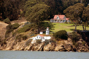
| CA 19 |
| Fort Point latitude 37° 48' 39.2" N longitude 122° 28' 37.8" W July 29, 2007 access: car + walk As you can see, this light is right on the front of the fort which is placed just below the Golden Gate Bridge. On this day, the fort was closed for reconstruction, so this was as close as I could get to the light. Just as with the Mackinaw light, this light is no longer in use, the bridge provides much better lighting of how to get in. MackinawPoint |
| CA 20 |
Yerba Buena latitude 37° 48' 26.2" N longitude 122° 21' 44.1" W July 29, 2007 access: ferry The island’s lighthouse connection began in 1873 when the Lighthouse Service moved the district's depot from Mare Island to the southeast side of Yerba Buena Island. In 1875 construction was completed on the 25 foot tower with a fifth order Fresnel lens. The light remains in active service today even though it basically is underneath the Bay Bridge (which illuminates the travel space very well.) We saw this light from the ferry between San Francisco and Oakland. It's a long shot, but on a clear day, it was good. (G 4140) |
|
| CA 21 |
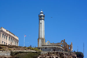
| Alcatraz latitude 37° 49' 34" N longitude 122° 25' 19.7" W July 30, 2007 access: tour The Baltimore firm of Gibbons and Kelly was awarded the contract to build seven lighthouses in California, at Alcatraz Island, Fort Point, Point Piños, Point Loma, Farallon Island, and Humboldt Bay, and one at Cape Disappointment Lighthouse in Washington State. The Alcatraz Lighthouse was completed in 1853 and is the oldest light in California. The best way to see this light is from one of the Bay Tour boats. All the tour lines do a full loop around Alkatraz, so you'll get a good view of both the light and the prison. (G 4082) |
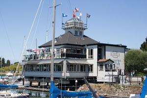
| CA 22 |
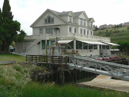
Oakland Harbor latitude 37° 46' 53.5" N longitude 122° 14' 35.7" W July 29, 2007 access: car The arrival of the Central Pacific railroad terminus at Oakland in 1869 heightened the need for a nearby link to shipping in San Francisco Bay. Consequently, two piers that were spaced 750 feet and extended two miles out into the bay were built, and the area around them was dredged to form a shipping terminal. This light is now the home of Quinn's restaurant. It's well away from anyplace, so we took a taxi from the ferry dock. Quinns |
|
| CA 22L |
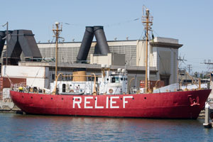
| Relief Lightship WLV-605 latitude 37° 47' 44.5" N longitude 122° 16' 50.3" W July 29, 2007 access: car Most lightships have the name of their location posted on their side. This one didn't have a permanent location, so instead, it has it's function - provide relief - painted on it's side. The boat is currently docked right next to the Oakland ferry terminal (to and from San Francisco.) |
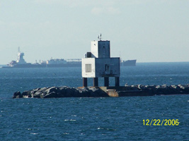
| CA 23 |
Old Carquinez Straits latitude 38° 4' 4.2" N longitude 122° 12' 49.5" W access: car About 20 miles north of San Francisco, this light was intended to assist boats sailing to Sacramento. Located at Glen Cove Marina in Vallejo Photo courtesy bobindrums [Flickr] |
|
| CA 23D | 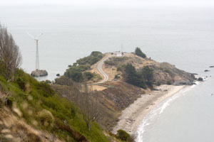
| Point Blunt July 27, 2007 access: ferry + walk (2? miles) This light marks the other side of Angel Island from Point Stuart (see above). From the Angel Island Ferry, we took the Segway tour around the island. That gave us a good chance to see the light from above. tour |
| CA 23B |
Point Stuart latitude 37° 51' 39.7" N longitude 122° 26' 46" W July 27, 2007 access: ferry There is some controversy over whether this really is/was a lighthouse. It looks like an aid to navigation, but it's pretty small. Located on Angel Island. This photo is taken from the Angel Island ferry. |
|
| CA 24 | 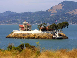
| East Brother latitude 37° 57' 47.6" N longitude 122° 26' 0.4" W access: overnight This light is now a bed and breakfast, and the best way to see the light is to spend a night there. (G 4215) Photo courtesy pwhsu48 [webshots] |
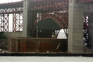
| CA 25 |
Lime Point latitude 37° 49' 32.6" N longitude 122° 28' 44.6" W July 30, 2007 access: boat Located right underneath the north end of the Golden Gate bridge, this light is no longer in service. This picture was taken from a Bay Harbor tour boat (with the long lens.) |
|
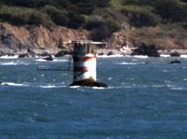
| CA 25D |
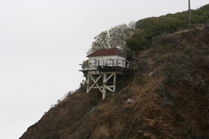
| Point Diablo latitude 37° 49' 12.5" N longitude 122° 29' 58" W July 30, 2007 access: boat Point Diablo is located roughly midway between Point Bonita and Lime Point on the northern side of the Golden Gate. The point protrudes some 600 feet into the waters from the Marin Headlands. In 1923, the Lighthouse Service decided to mark this navigational hazard, and a small white shack with a pitched red roof was placed on the sloping point some eighty feet above the water. This photo was taken from a Bay Harbor tour boat, but they don't always go this far out. |
| CA 26 |
Point Bonita latitude 37° 48' 56" N longitude 122° 31' 46.5" W November 16, 2002 access: car + walk (1/2 mile) Originally built high atop a hill, the light was often shrouded in fog while the lower elevations remained clear. This light was lit in 1877 after major efforts to modify the land were done so you could get to the site. Point Bonita Lighthouse is reached by a halfmile trail that is steep in parts. Discover Point Bonita’s wild landscape, geology and fascinating history. The tunnel halfway to the lighthouse is open only during visiting hours: Saturdays, Sundays & Mondays 12:30 p.m. to 3:30 p.m. park (G 4052) |
|
| CA 27 | 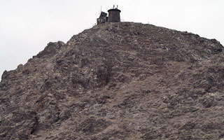
| Farallon Islands latitude 37° 41' 52.3" N longitude 123° 1.4" W access: boat Thirty miles west of San Francisco a collection of small, rocky islands is found. The largest and tallest of the islands is southeast Farallon, which rises to a height of 358 feet. It was atop this island that the Farallon Island Lighthouse was constructed. While an active birding site, this is difficult to get to. You'll need a boat ride to the island, and a crane ride to get from the water to the walkable surface |
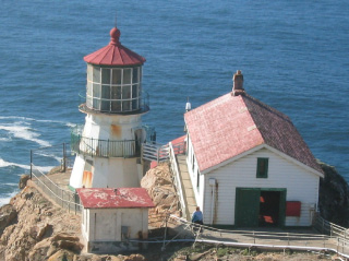
| CA 28 |
Point Reyes latitude 37° 59' 43.7" N longitude 123° 1' 23" W November 16, 2002 access: car Lit in 1870, retired in 1975, this light is part of a gorgeous sea shore and part of the National Park Service. Once you arrive at the parking lot, you have a 300 foot walk down to the lighthouse. (G 4356) |
|
| CA 28n |
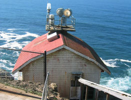
| Point Reyes (new) November 16, 2002 access: car This is the current active light at Point Reyes It is physically just in front of the old fog building (and basically invisible from above for that reason.) |
| CA 29 |
Point Arena latitude 38° 57' 16.7" N longitude 123° 44' 26" W access: car The Mendocino Coast is home to one of the tallest lighthouse towers in the west. Dramatically perched on a narrow peninsula, the Point Arena Lighthouse Tower is 115 ft. high. Erected in 1870, destroyed by the 1906 earthquake, and rebuilt the following year, it was the first lighthouse to be made of steel and concrete. The lighthouse is located at 45500 Lighthouse Road, one mile north of the city of Point Arena and 135 miles north of San Francisco. * (G 4358) |
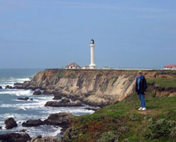
|
| CA 30 | 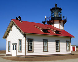
| Point Cabrillo latitude 39° 20' 55.3" N longitude 123° 49' 34.2" W access: car Point Cabrillo is easy to find. We're just north of Mendocino, California. From Highway 1, turn onto Pt. Cabrillo Road at Russian Gulch and follow the signs. We're 1.3 miles from Russian Gulch. (G 4362) |
| CA 31 |
Punta Gorda latitude 40° 14' 57.8" N longitude 124° 21' 1.6" W access: boat Punta Gorda Lighthouse was built in 1911 and was first lit in 1912. After World War II, it was decided that given the remoteness of the station it was too costly to maintain. A lighted buoy was placed offshore, the fourth order Fresnel lens was removed, and the station was boarded up and deactivated in 1951. The keeper's house and all other station buildings were demolished. |
|
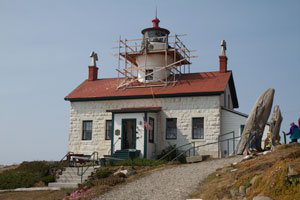
| CA 32 |
| Cape Mendocino latitude 40° 1' 20.4" N longitude 124° 4' 9.9" W access: car The light at Cape Mendocino was activated on December 1, 1868. The light was automated by the Coast Guard in 1951 and then abandoned in the 1970s. The old 1868 lighthouse was relocated in 1998 to Shelter Cove, and the original first order Fresnel lens was transferred to a replica in Ferndale, California where it sits in a replica tower at the entrance of the Humboldt County Fairgrounds. In 1998 a group of volunteers dismantled the lighthouse and reassembled it in Mal Coombs Park in Shelter Cove, California. |
| CA 33 |
Old Table Bluff latitude 40° 48' 29.5" N longitude 124° 9' 59.4" W access: car The station was patterned after the one built in 1890 at San Luis Obispo and consisted of a square tower attached to an ornate Victorian dwelling, a fog signal building, and an assistant keeper’s duplex all lined up along the edge of the bluff. The lighthouse is located on Woodley Island in Eureka. |
|
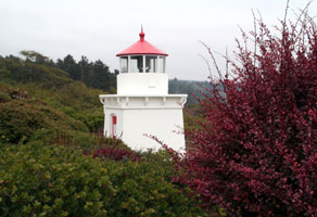
| CA 34 | 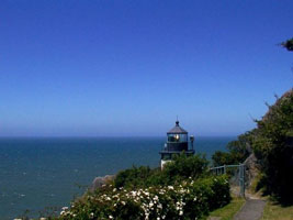
| Trinidad Head latitude 41° 3' 4.5" N longitude 124° 9' 2.7" W access: car Trinidad Head Lighthouse was built on the Trinidad Harbor in 1871. In 1947, the lens was changed from the fourth order Fresnel lens to a to a 375 mm optic. The lighthouse was automated by the United States Coast Guard in 1974. The Trinidad Lighthouse is located high on the southwest side of the headland at Trinidad. * (G 4408) |
| CA 35 |
Trinidad Memorial Lighthouse access: car In 1949 a club built a concrete Trinidad Memorial Lighthouse, an accurate replica that many visitors believe to be the actual Trinidad Head Lighthouse. Located at the intersection of Trinity Street and Edwards in Trinidad. |
|
| CA 36 |
| Battery Point latitude 41° 44' 38.8" N longitude 124° 12' 11.1" W September 24, 2012 access: walk Battery Point Lighthouse and Museum are located at the foot of A Street in Crescent City, California. This is an active lighthouse that serves as a private aid to navigation. The Lighthouse was first lit with oil lamps on December 10, 1856. The Lighthouse is also an active residence with lighthouse keeper. The Lighthouse and its museum is open to the public. There is tidal land on the path from A Street to the light, so it may not be possible to walk there at high tide. (G 4417.5) |
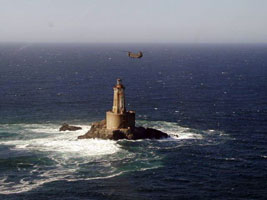
| CA 37 |
St. George Reef access: tour Perched on an exposed rock off the coast of northern California near Crescent City, St. George Reef Lighthouse took 10 years to build. The SGRLPS is now offering helicopter flights and tours of the lighthouse to the public. The tours will be scheduled, weather permitting, departing from the Crescent City Airport, passengers enjoy a six minute flight to the lighthouse, landing on the caisson roof, near the base of the tower. From there they are greeted by Society Representatives and taken for a one hour tour. |
|
| CA 38 |

| Southampton Shoals access: none Southampton Shoal, a two-mile-long navigational hazard, lies along the eastern side of the shipping channel that runs between Berkeley on the east, and Angel Island and the Tiburon Peninsula on the west. Remnants of the lighthouse remain behind in San Francisco Bay. Photo courtesy USCG [USCG] |