|
This page shows the documentation of the Lighthouses of Southeastern Sweden. You can always click on the photo of the light to go to a specific (larger resolution) copy. Each lighthouse name is linked to (in our editorial opinion) the best reference site for that light. I would like to include directions on how to get to these lights. If you know such data, could you eMail me and I'll post it here (with your choice of attribution.) mailme This list was built based on the list maintained by the Amateur Radio Lighthouse Society. My thanks to them for providing this basis for understanding. w8 |
|
Södermanlands Län
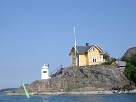
| SW 128 |
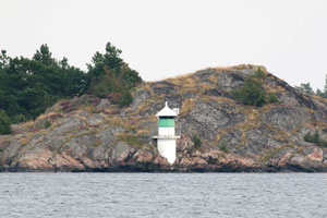
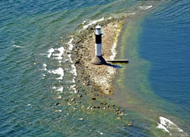
Bokø
latitude 58° 50' 58.7" N longitude 17° 36' 0.3" E
Located at the northwestern tip of the long, slender island of Askö, about 4 km southeast of Trosa. ARLHS # SWE-099
Photo courtesy Anonymous [wikipedia] |
|
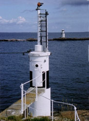
| SW 129 |
| Måsknuv
Måstnuv is a small island just west of the larger island of Mälsten. Located at the western tip of the island, about 5 km southeast of Nynäshamn. Tours to the island are available. (C 6596) ARLHS # SWE-278
Photo courtesy marinas.com [marinas.com] |
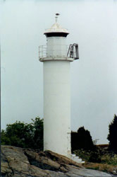
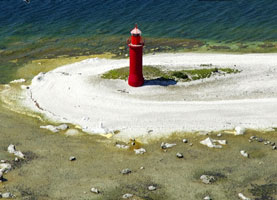
| SW 130 |
Asenskallen
Located on the southeastern tip of Askö. (C 6732) ARLHS # SWE-086
Photo courtesy Bengt Agild [webshots] |
|
| SW 131 |
Skvallran |
Located about 600 m northeast of the Asenskallen lighthouse, off the southeastern tip of Askö. (C 6730) ARLHS # SWE-351 |
| SW 132 |
Skrappen
Located on a small island about 6 km east of Öja and 8 km south of Nynäshamn. ARLHS # SWE-350
Photo courtesy Bengt Agild [webshots] |
|
| SW 133 |
Tilljandersknallt |
Located on a shoal about 3 km south of Torö and 2 km west of Öja. (C 6585) ARLHS # SWE-391 |
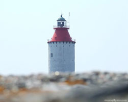
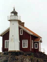
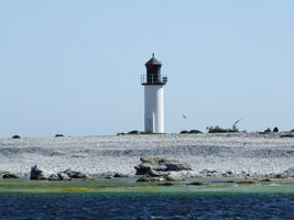
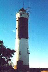
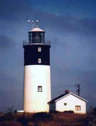
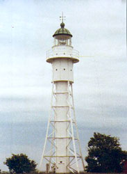
| SW 134 |
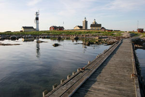
Landsort
latitude 58° 44' 22.4" N longitude 17° 51' 56.2" E
Sweden's oldest lighthouse station is located at the Southern tip of the island of Öja. (C 6584) ARLHS # SWE-039
Photo courtesy Tommy Asplund [Flickr] |
|
| SW 135 |
| Landsorts Bredgrund
Located on a shoal about ¾ mile southeast of the Landsort lighthouse. (C 6583.6) ARLHS # SWE-231
Photo courtesy Tommy Asplund [Flickr] |
| SW 136 |
Hartsø Stångskær |
Located on a skerry off the southern point of Hartsön, an island on the south side of Langön. ARLHS # SWE-185 |
| SW 137 |
Oxeløsund |
Located at the water's edge on the south side of Oxelösund. Drive road 53 to Oxelösund. Follow the signs, first for Femöre, then for Femörefortet. Park in the large car park and walk along the track to the fortress entrance. ARLHS # SWE-308 |
| SW 138 |
Lillehammarsgrund |
Located on a skerry about 6 mile east of Oxelösund. (C 6800) ARLHS # SWE-259 |
| SW 139 |
Græsskæren |
Located on a skerry about 5 miles southeast of Oxelösund. ARLHS # SWE-154 |
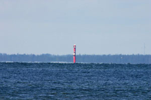
| SW 140 |
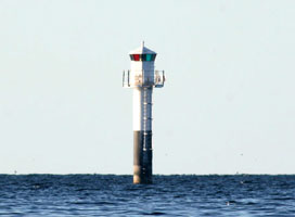
Norra Krænkan
latitude 58° 36' 55.9" N longitude 17° 23' 10.3" E |
ARLHS # SWE-293 |
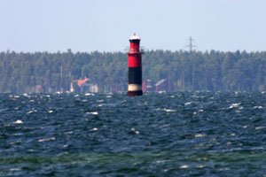
| SW 141 |
Hævringe
Hävringe is a small island about 6 miles east southeast of Oxelösund. (C 6832) ARLHS # SWE-025
Photo courtesy Esbjörn Hillberg (Swedish Lighthouse Society) [fyr] |
|
| SW 142 |
| Hævringe Rear (C 6832.1) ARLHS # SWE-188
Photo courtesy Esbjörn Hillberg (Swedish Lighthouse Society) [fyr] |
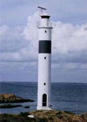
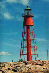
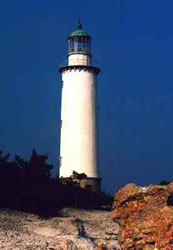
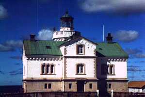
| SW 143 |
Gustaf Dalen |
Located in the Baltic about 6 km south of Langön. (The light is named for the inventor of many lighthouse technology products including the flashing apparatus and the sun valve (which turned the light off at sunrise.)) (C 6829) ARLHS # SWE-166 |
Östergötlands Län
| SW 144K |
| Kopparholmen (Nedre)
latitude 58° 29' 1.5" N longitude 16° 57' 41.6" E
This light is the front light of a range guiding vessels northward to Arkösund; the Kuggviksskär light is the rear light. Located on the west point of Östra Kopparholmen, about 1.2 km south of the southeastern tip of Gränsö. (C 6872)
Photo courtesy Alex Trabas [ListOfLights] |
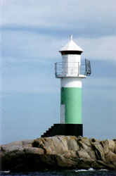
| SW 145 |
Kuggviksskær (Kopparholmen Övre)
latitude 58° 28' 47.1" N longitude 16° 57' 57.7" E
Located on a skerry off the southeastern tip of Gränsö and about 2 km southeast of Arkösund. (C 6872.1) ARLHS # SWE-224
Photo courtesy Esbjörn Hillberg (Swedish Lighthouse Society) [fyr] |
|
| SW 211 |
| Viskær
latitude 58° 29' 18.9" N longitude 16° 59' 27.3" E
Deactivated in 1887, it was relocated in 1890 to Storkläppen, an island in Kalmar. However, that station was devastated by a storm in November of the same year. The tower survived, and in 1894 it was relocated a second time to Viskär. The house is now a private residence, and the owners have maintained the lighthouse in excellent condition. Located on an island about 2.5 km east of Arkösund. ARLHS # SWE-324
Photo courtesy Esbjörn Hillberg (Swedish Lighthouse Society) [fyr] |
| SW 146 |
Norra Fællbåden |
ARLHS # SWE-292 |
|
|
| SW 147 |
Gotska Sandön |
This is one of two twin towers built here. The other tower was deactivated and removed in 1903. Located on a bluff at the northwestern tip of Gotska Sandön; accessible by hiking trails. ARLHS # SWE-020 |
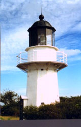
| SW 148 |
Gotska Sandøn Northwest Point ARLHS # SWE-021
Photo courtesy Alex Trabas [ListOfLights] |

|
| SW 149 |
Kyrkudden (Gotska Sandøn Island) |
Located at the eastern top of Gotska Sandøn Island. (C 7156) ARLHS # SWE-227 |
| SW 150 |
Hamnudden (Gotska Sandøn Island) |
Located on the SW tip of Gotska Sandøn Island. (C 7154) ARLHS # SWE-178 |
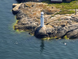
| SW 151 |
Häradskär (C 7022) ARLHS # SWE-180
Photo courtesy Esbjörn Hillberg (Swedish Lighthouse Society) [fyr] |
|
| SW 152 |
Hægerøkarten |
ARLHS # SWE-167 |
Kalmar Län
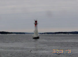
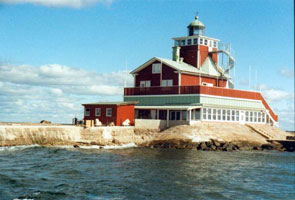
| SW 153 |
Nidingen II
latitude 57° 55' 20.1" N longitude 19° 2' 22.6" E
Transportation for both day and overnight visitors is available from Gottskär on the mainland. The twin towers are located in the Kattegat about 10 km southwest of Gottskär. ARLHS # SWE-428
Photo courtesy Patrik Jonasson [pbase] |
|
| SW 155 |
Finnhællen
latitude 57° 52' 1.2" N longitude 16° 48' 1.4" E |
Located on a skerry about 3 miles east of Källvik ARLHS # SWE-130 |
| SW 156 |
Stor-kläppen
The original lighthouse was an iron tower transferred from Utholme. Located on an island about 6 miles southeast of Källvik. (C 7068) ARLHS # SWE-374
Photo courtesy marinas.com [marinas.com] |
|
| SW 158 |
Finnkarten
Located close to the Saldö Ask light; NGA has the two with the same coordinates. (C 7072) ARLHS # SWE-131
Photo courtesy Esbjörn Hillberg (Swedish Lighthouse Society) [fyr] |
|
| SW 159 |
| Sladø Ask
Located about 1.5 km southeast of the eastern tip of the island of Hasselö. ARLHS # SWE-352
Photo courtesy Esbjörn Hillberg (Swedish Lighthouse Society) [fyr] |
| SW 160 |
Væsterbåden
Located offshore about 2 miles northeast of Lindödjupet. ARLHS # SWE-420
Photo courtesy Anonymous (w. permission) [Flickr] |
|
| SW 161 |
| Kungsgrundet
Located about 6 miles east of Lindödjupet. (C 7078) ARLHS # SWE-225
Photo courtesy Alex Trabas [ListOfLights] |
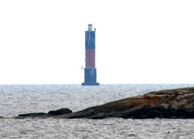
| SW 162 |
Bussgrund
Located on a shoal about ¾ mile east of the island of Händelöp, southeast of Västervik. (C 7108) ARLHS # SWE-112
Photo courtesy Alex Trabas [ListOfLights] |
|
| SW 163 |
Hamnklabbshællen |
Located about 1.5 km east of the Bussgrund lighthouse. (C 5789) ARLHS # SWE-177 |
| SW 164 |
Strupø Ljungskær
Located on a skerry about 1.5 km northeast of the Vino Bredhall light. (C 7132) ARLHS # SWE-379
Photo courtesy Alex Trabas [ListOfLights] |
|
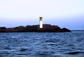
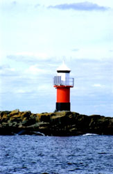
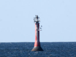
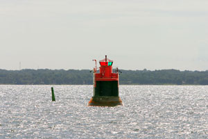
| SW 167 |
Nygrån
latitude 57° 22' 1" N longitude 17° 5' 49.6" E |
ARLHS # SWE-298 |
|
|
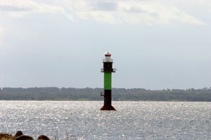
| SW 168 |
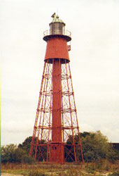
Finnrevet
Located on a shoal about 6 miles east of Oskarshmn, SE coast of Sweden. Ferries from Oskarshamn to Gotland pass by. (C 7292) ARLHS # SWE-013
Photo courtesy marinas.com [marinas.com] |
|
| SW 170 |
Støtbotten
Located about 5 km east of the Oskarshamn harbor entrance. (C 7295.5) ARLHS # SWE-375
Photo courtesy Alex Trabas [ListOfLights] |
|
| SW 171 |
| Fårö (Gotland Island)
On the Eastern tip of the island. (C 7160) ARLHS # SWE-011
Photo courtesy Esbjörn Hillberg (Swedish Lighthouse Society) [fyr] |
| SW 172 |
Svingrund (Gotland Island)
Located about .6 miles off NE point of Gotland island, marking the NW entrance to Fårösund. (C 7161) ARLHS # SWE-388
Photo courtesy Alex Trabas [ListOfLights] |
|
| SW 172A |
| Aurgrund
Located on a small island marking the northeast entrance to the Fårösund. (C 7170) ARLHS # SWE-429
Photo courtesy Tommy Aslund [Flickr] |
| SW 173 |
Hallshuk (Gotland Island)
Located at the entrance to Kappelshamn, north coast of Gotland. (C 7250) ARLHS # SWE-026
Photo courtesy Esbjörn Hillberg (Swedish Lighthouse Society) [fyr] |
|
| SW 174 |
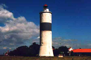
| Stenkyrkehuk (Gotland Island)
Located on the NW coast of Gotland Island. (C 7246) ARLHS # SWE-062
Photo courtesy Esbjörn Hillberg (Swedish Lighthouse Society) [fyr] |
| SW 175 |
Grauten (Gotland Island)
On the NE coast of Gotland Island. (C 7178) ARLHS # SWE-155
Photo courtesy marinas.com [marinas.com] |
|
| SW 176 |
| Ostergarn (Gotland Island)
latitude 57° 26' 32.2" N longitude 18° 59' 6" E
On an island off the east coast of Gotland Island. This light is at the East End. (C 7188) ARLHS # SWE-306
Photo courtesy Esbjörn Hillberg (Swedish Lighthouse Society) [fyr] |
| SW 176W |
Ostergarn West (Gotland Island)
On an island off the east coast of Gotland Island. This light is at the West End. (C 7189)
Photo courtesy Ina Rendtel [ListOfLights] |
|
| SW 177 |
| Stora Karlsø (Gotland Island)
Located on an island about 3 miles off the SW coast of Gotland Island. (C 7224) ARLHS # SWE-371
Photo courtesy Esbjörn Hillberg (Swedish Lighthouse Society) [fyr] |
| SW 178 |
När (Gotland Island)
latitude 57° 13' 5.9" N longitude 18° 40' 51.7" E
Located on the east coast of Gotland Island. (C 7200) ARLHS # SWE-049
Photo courtesy Esbjörn Hillberg (Swedish Lighthouse Society) [fyr] |
|
| SW 179 |
| Ronehamn (Gotland Island)
The light is located about 2.5 miles east of Rohehamn, on the east coast of the Gotland Island.
(C 7202) ARLHS # SWE-327
Photo courtesy Alex Trabas [ListOfLights] |
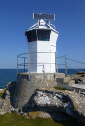
| SW 180 |
Näsrevet (Gotland Island) |
Located on the north side of the entrance to Burgsvik Hamn (harbor), SW coast of Gotland. (C 7211) ARLHS # SWE-286 |
| SW 181 |
Faludden (Gotland Island)
On the SE coast of Gotland Island. ARLHS # SWE-010
Photo courtesy Esbjörn Hillberg (Swedish Lighthouse Society) [fyr] |
|
| SW 182 |
| Hoburg (Gotland Island)
On the SW end of Gotland Island. ARLHS # SWE-031
Photo courtesy Esbjörn Hillberg (Swedish Lighthouse Society) [fyr] |
| SW 183 |
Heligholmen (Gotland Island) |
On a small island off the southern end of Gotland. ARLHS # SWE-189 |
| SW 185 |
Dämman I
This light has been restored and is now the Dämman WaterHotel. It can be accessed by boat from Sandvick and is located on the west coast of Øland Island. ARLHS # SWE-113
Photo courtesy Esbjörn Hillberg (Swedish Lighthouse Society) [fyr] |
|
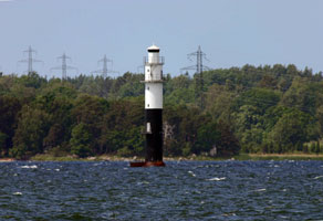
| SW 186 |
| Dæmman II (Kalmar Sound) (C 7324) ARLHS # SWE-114
Photo courtesy Alex Trabas [ListOfLights] |
| SW 188 |
Masknaggen
Located in the northern Kalmarsund on the SE coast of Sweden. (C 7350) ARLHS # SWE-277
Photo courtesy Helmut Seger [ListOfLights] |
|
| SW 189 |
| Krongrundet
latitude 56° 41' 24.2" N longitude 16° 24' 15.7" E
Located in the Kalmar Channel. (C 7352) ARLHS # SWE-432
Photo courtesy Helmut Seger [ListOfLights] |
| SW 189B |
Osvallsgrundet
latitude 56° 39' 6.3" N longitude 16° 23' 19.8" E
Located about 500 m. northeast of the Huvudet lighthouse. (C 7358)
Photo courtesy Jette&Ole [tjow] |
|
| SW 189H |
| Huvudet
latitude 56° 40' 1.1" N longitude 16° 23' 6.5" E
Located about 2 km northeast of the Skansgrundet lighthouse. (C 7358.4)
Photo courtesy Helmut Seger [liteslist] |
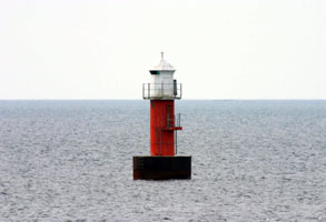
| SW 190 |
Skansgrundet
latitude 56° 39' 7" N longitude 16° 22' 29.8" E
Located on a shoal about ½ mile from Kalmar. (C 7390) ARLHS # SWE-346
Photo courtesy Helmut Seger [ListOfLights] |
|
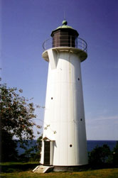
| SW 191 |
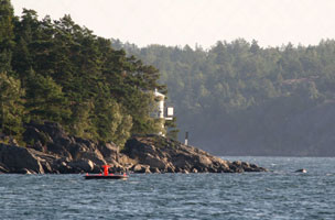
| Garpen I
latitude 56° 23' 25.5" N longitude 16° 7' 43.9" E
Overnight accommodations are available in the keeper's houses, and there is a small café. Located on a small island in the southern Kalmarsund about 3 km east of Söderåkra. (C 7416) ARLHS # SWE-016
Photo courtesy Esbjörn Hillberg (Swedish Lighthouse Society) [fyr] |
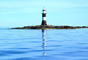
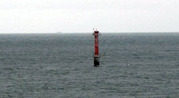
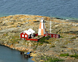
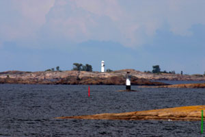
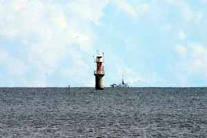
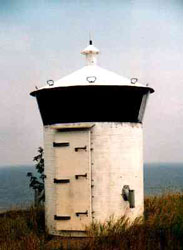
| SW 192 |
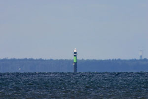
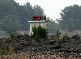
Garpen II
latitude 56° 23' 24.6" N longitude 16° 7' 43" E
The new light is the small red thing on the right edge of the photo. ARLHS # SWE-145
Photo courtesy Esbjörn Hillberg (Swedish Lighthouse Society) [fyr] |
|
| SW 193 |
| Ølands Norra Udde (Långe Erik)
latitude 56° 22' 1.6" N longitude 16° 5' 49.2" E
Located on a small island at the northeastern tip of Öland. (C 7260) ARLHS # SWE-298
Photo courtesy Gloria Stevenson [Flickr] |
| SW 194 |
Slottsbredan (Øland Island)
In northern Kalmarsund, about 3 miles NW of Öland, SE coast of Sweden. (C 7332) ARLHS # SWE-353
Photo courtesy Alex Trabas [ListOfLights] |
|
| SW 195 |
| Kapelludden (Øland Island)
latitude 56° 49' 10.2" N longitude 16° 50' 42.3" E
A red iron skeletal tower on the east side of Øland Island. (C 7270) ARLHS # SWE-211
Photo courtesy Esbjörn Hillberg (Swedish Lighthouse Society) [fyr] |
| SW 195S |
Sillåsen
The lighthouse marks a narrow passage in the northern Kalmarsund. Located about 2 km east of Revsudden. (C 7340) ARLHS # SWE-338
Photo courtesy Alex Trabas [ListOfLights] |
|
| SW 196 |
| Högby (Øland Island)
latitude 57° 8' 47.6" N longitude 17° 2' 49.5" E
A white skeletal tower on the NE coast of Øland Island. (C 7266) ARLHS # SWE-032
Photo courtesy Esbjörn Hillberg (Swedish Lighthouse Society) [fyr] |
| SW 197 |
Utgrunden
Located on a shoal in the southern entrance to Kalmarsund. (C 7420) ARLHS # SWE-405
Photo courtesy Alex Trabas [ListOfLights] |
|
| SW 198 |
| Segerstad (Øland Island)
latitude 56° 22' 6.3" N longitude 16° 34' 1.3" E
Located on the SE coast of Øland Island. (C 7274) ARLHS # SWE-057
Photo courtesy Esbjörn Hillberg (Swedish Lighthouse Society) [fyr] |
| SW 200 |
Ølands Södra Grund (Øland Island) (C 7284) ARLHS # SWE-299
Photo courtesy Captain Peter Mosselberger [ListOfLights] |
|
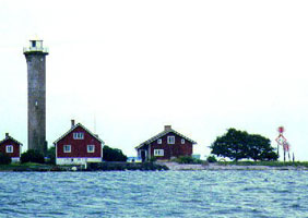
| SW 201 |
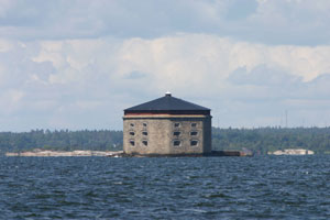
| Godnatt
This is an Octagonal stone building with a dark blue metal roof. The lantern is mounted on the center of the roof. It is located about 1 mile south of Karlskrona. (C 7449)
Photo courtesy Alex Trabas [ListOfLights] |
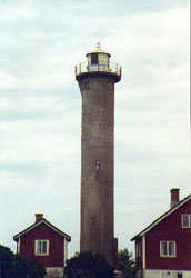
| SW 202 |
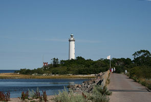
Ölands Södra Udde (Lange Jan)
On the southern tip of the island. photo (C 7280) ARLHS # SWE-041
Photo courtesy Esbjörn Hillberg (Swedish Lighthouse Society) [fyr] |
|
|
|

 Eastern Sweden
