|
This page shows the documentation of the Lighthouses of Uruguay. The pictures below are linked to the relevant photo on the web (thus making available to you a higher resolution picture.) I am very grateful to Russ Rowlett at the University of North Carolina for his excellent Lighthouse Directory for the outline. Each lighthouse name is linked to (in our editorial opinion) the best reference site for that light. LHdirectory |
|
| UR 1 |
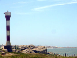
Punta Palmar
Located off national route 9 about 40 km northeast of Castillos. The light is surrounded by private property.
Photo courtesy BetaLima [Flickr] |
|
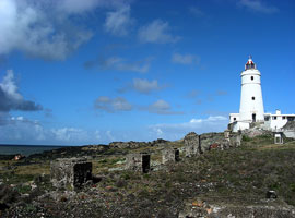
| UR 2 |
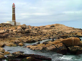
| Cabo Polonio
The lighthouse marks a rocky point in an otherwise sandy area; offshore are islands with colonies of seals. There's no road access, but the light can be reached by hiking on the beach from nearby resorts. Guided tours are available. Located off national route 9 about 25 km south of Castillos.
Photo courtesy libertinus [Flickr] |
| UR 3 |
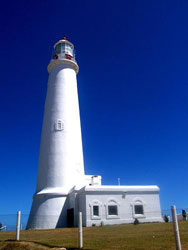
Cabo Santa Maria (La Paloma)
Located on the cape in the seaside resort of La Paloma, at the end of national route 15.
Photo courtesy Bossa [Flickr] |
|
| UR 4 |
| Punta José Ignacio
Located in a popular resort area on the coastal road (national route 10) about 55 km southwest of La Paloma. resort
Photo courtesy Ferrando [Flickr] |
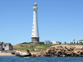
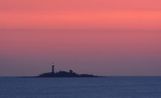
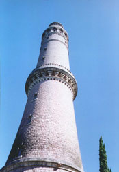
| UR 5 |
Isla de Lobos
Uruguay's tallest lighthouse, also one of the tallest concrete lighthouses in the world. Located on a small (90 acre) island about 13 km southeast of Punta del Este. Accessible only by boat. (G 0676)
Photo courtesy Priscilla JP [Flickr] |
|
|
|
| UR 6 |
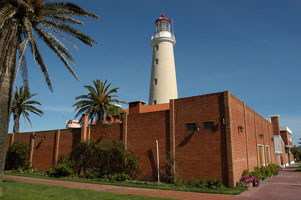
| Punta del Este
The narrow peninsula of Punta del Este is the southernmost point of Uruguay; it encloses the east side of the Bahía de Maldonado and is the extreme eastern end of the Río de la Plata embayment and estuary. Located near the end of the peninsula in the resort city of Punta del Este. (G 0690)
Photo courtesy Vince Alongi [Flickr] |
| UR 7 |
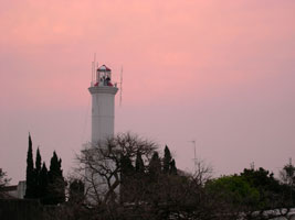
Isla de Flores
The island is about 12 km offshore in the Río de la Plata and about 32 km east of Montevideo.
Photo courtesy betitu [Flickr] |
|
| UR 7U |
| Yacht Club Uruguayo
Located at the Puerto del Budeo on the east side of Montevideo.
Photo courtesy pizzadebarr [Flickr] |
|
|
| UR 8 |
Punta Brava (Punta Carretas)
Located at the end of the point on the southeastern side of the city of Montevideo. (G 0700)
Photo courtesy gusuval [Flickr] |
|
| UR 9 |
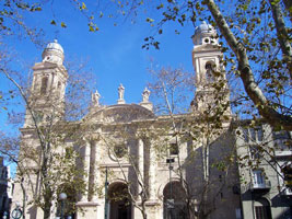
| Montevideo Catedral Metropolitana
The light was removed after mariners complained it was difficult to distinguish from other lights of the city. Located in the old part of the city, which is on a peninsula jutting into the Río de la Plata.
Photo courtesy Baires [webshots] |
| UR 10 |
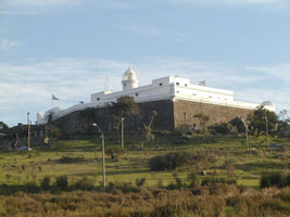
El Cerro de Montevideo
Uruguay's oldest lighthouse, built by Spain before Uruguay became independent. The fortress is now a military museum, the Museo Militar Fortaleza General Artigas. Located atop the hill (cerro) for which the city is named, but across the harbor (west) from the main part of the modern city. (G 0702)
Photo courtesy Santo [webshots] |
|
| UR 11 |
La Penela |
Located in the Río de la Plata about 10 km west of Cerro de Montevideo. Accessible only by boat. |
| UR 12 |
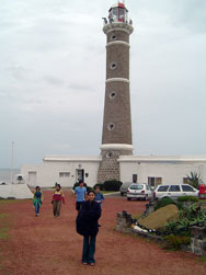
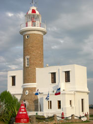
Colonia del Sacramento
The lighthouse is built within the ruins of the Convento de San Francisco Javier, built by the Portuguese in 1682. Also adjacent to the light station is the municipal museum of this historic city, which faces Buenos Aires across the broad Río de la Plata estuary. Located in the historic district of the city, on a peninsula extending into the Río de la Plata.
Photo courtesy gusuval [Flickr] |
|
| UR 13 |
| Isla de Farallon
The keeper's house is abandoned and probably endangered. Located on an island in the Río de la Plata about 5 km southwest of Colonia del Sacramento. Accessible only by boat.
Photo courtesy Gonzalo Sainz-Trápaga [Flickr] |
| UR 14 |
La Torre Anchorena (Faux)
At the confluence of the Río San Juan and the Río de la Plata. While intended as a lighthouse, it's never be listed as an aid to navigation.
Photo courtesy Paula y Diego [Flickr] |
|
|
|

 Brazil