|
This page currently shows the documentation about the Lighthouses of Western Mexico. In addition, the pictures below are linked to the relevant photo on the web (thus making available to you a higher resolution picture.) I am very grateful to Russ Rowlett at the University of North Carolina for his excellent Lighthouse Directory from which I built the outline. Each lighthouse is linked to (in our editorial opinion) the best reference site for that light. LHdirectory |
|
Baja California
| MX 68 |
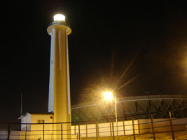
Tijuana
latitude 32° 32' 3.4" N longitude 117° 7' 22.1" W
The lighthouse was built fairly recently as part of a plan to develop Tijuana's beachfront. Located next to the beach just a few feet from the U.S. border and the "Bullring by the Sea" (Plaza de Toros Monumental), which is part of the same development. ARLHS # MEX-083
Photo courtesy TJ [Flickr] |
|
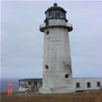
| MX 69 |
Islas las Coronados North (old)
latitude 32° 25' 5.6" N longitude 117° 14' 58.1" W |
The islands are about 42 km southwest of San Diego. Located on a ridge at the north end of South Coronado Island. Accessible only by boat. ARLHS # MEX-111 |
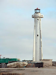
| MX 70 |
Islas las Coronados North (new)
latitude 32° 24' 58.6" N longitude 117° 14' 53.4" W |
Located high on the ridge above the older lighthouse. Accessible only by boat. ARLHS # MEX-110 |
| MX 71 |
Islas las Coronados South
latitude 32° 23' 29" N longitude 117° 14' 29.6" W |
Located on a steep rocky bluff at the south end of South Coronado Island. Accessible only by boat. ARLHS # MEX-112 |
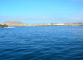
| MX 72 |
Islas de Todos Santos (old)
latitude 31° 48' 42.7" N longitude 116° 48' 28.5" W ARLHS # MEX-109
Photo courtesy Brian Mcstotts [Flickr] |
|
| MX 73 |
| Islas de Todos Santos (new)
latitude 31° 48' 43.8" N longitude 116° 48' 28.1" W
The lights are on the northwest tip of the northern of the two islands of Todos Santos, located in the Bahía de Ensenada about 20 km west of Ensenada. The islands are well known as a surfing site. Accessible only by boat. ARLHS # MEX-078
Photo courtesy Leonardo Galicia [Flickr] |
| MX 74 |
Punta San José
A site popular with surfers, Punta San José is 24 miles west of Santo Tomas by a dirt road. The lighthouse stands on a bluff overlooking the beach. ARLHS # MEX-184
Photo courtesy Kevin [Flickr] |
|
| MX 75 |
Isla San Jeronimo
latitude 29° 47' 29.7" N longitude 115° 47' 31.8" W |
This lighthouse is probably typical of many small light towers on the Mexican coast. Located at the summit of the island southwest of San Quintín. Accessible only by boat. photo ARLHS # MEX-108 |
| MX 76 |
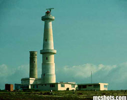
Islas San Benito
latitude 28° 18' 31.3" N longitude 115° 35' 56.9" W |
The islands, home to numerous birds and elephant seals, are a popular destination for ecotours, which often visit the lighthouse. Located atop the largest island, located northwest of Isla Cedros and about 80 km west of the peninsula. ecotours
Phillip Colla has a photo oceanlight ARLHS # MEX-071 |
| MX 77 |
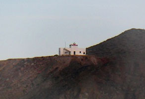
Isla Cedros
latitude 28° 21' 40" N longitude 115° 11' 41.5" W
Located at the northern point of Isla Cedros, a large island, about 65 km west northwest of Guerrero Negro. Accessible only by boat.
Photo courtesy Alejandro Lopez Ceja [skyscrapercity] |
|
| MX 78 |
| Guerrero Negro (Puerto Venustiano Carranza, Laguna Ojo de Liebre
latitude 28° 2' 8.8" N longitude 114° 7' 5.5" W
This lighthouse guided ships arriving to load salt at the Laguna Ojo de Liebre, also called Scammon's Lagoon. Located at the wharf of the salt works, about 12 km southwest of Guerrero Negro.
Photo courtesy prosciutoemelone [webshots] |
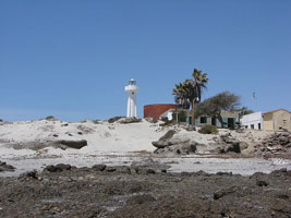
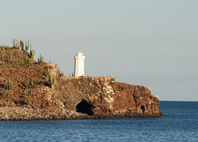
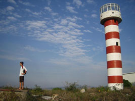
| MX 79 |
Isla Natividad
latitude 27° 51' 56" N longitude 115° 10' 33.6" W
Natividad is off Punta Eugenia, about 65 km west of Guerrero Negro. The island is popular with surfers. Located at the highest point of the island (which is the left of this photo). ARLHS # MEX-040
Photo courtesy M. Luna [Flickr] |
|
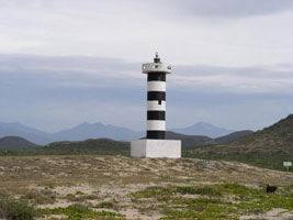
| MX 80 |
| Punta Abreojos
latitude 26° 42' 29" N longitude 113° 34' 31.4" W
Punta Abreojos is at the end of 84 km of dirt road. Located on the beach at the south end of town. ARLHS # MEX-047
Photo courtesy peter leupold [Flickr] |
| MX 81 |
Puerto López Mateos
latitude 25° 11' 36.1" N longitude 112° 7' 20.4" W |
Located on the waterfront of Puerto López Mateos. photo |
| MX 82 |
Cabo San Lazaro
latitude 24° 47' 35.6" N longitude 112° 18' 4" W
Located on the cape, which juts into the Pacific west of San Marcos. This is a remote site, difficult to access. ARLHS # MEX-102
Photo courtesy Stephen & Darusha [Flickr] |
|
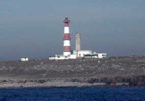
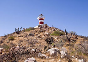
| MX 83 |
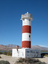
Punta Tosca
latitude 24° 18' 35.9" N longitude 111° 42' 42.3" W |
Located on the point of Punta Tosca, the rugged southermost tip of Isla Santa Margarita, at the southern end of Bahía Magdalena. Accessible only by boat. ARLHS # MEX-128 |
| MX 84 |
Todos Santos
Located near Todos Santos, a town about 45 km north of Cabo San Lucas. ARLHS # MEX-077
Photo courtesy Shiloh [webshots] |
|
| MX 85 |
| Cabo Falso (1890) (Faro Viejo)
latitude 22° 52' 25.2" N longitude 109° 57' 51.5" W
Despite its name, the lighthouse is not truly at Cabo Falso but is at the westernmost extension of Cabo San Lucas about 5 km southwest of the town. Located atop a bluff at a point of the cape. ARLHS # MEX-101
Photo courtesy Salvador Garcia [Flickr] |
| MX 86 |
Cabo Falso (1967)
latitude 22° 52' 40.1" N longitude 109° 57' 34.2" W
Located at the top of Las Hermanas hill above the cape. Don't confuse this place with the light in Honduras. HO 6 ARLHS # MEX-100
Photo courtesy Salvador Garcia [Flickr] |
|
|
|
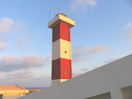
| MX 87 |
| Cabo San Lucas Range Front
latitude 22° 52' 51.3" N longitude 109° 54' 40.8" W
The lighthouse is built on the roof of the Costa Real Cabo resort hotel on the Cabo San Lucas beachfront, overlooking the yacht harbor. ARLHS # MEX-103
Photo courtesy angel1349 [webshots] |
Sea of Cortez
| MX 88 |
San José del Cabo
latitude 23° 3' 40.9" N longitude 109° 40' 6.7" W |
San José del Cabo is about 40 km northwest of Cabo San Lucas photo ARLHS # MEX-074 |
| MX 89 |
Punta Arena Sur (La Ribera)
latitude 23° 33' 12.9" N longitude 109° 28' 10.5" W |
Located several miles south of La Ribera and 18 km north of Cabo Pulma at the north end of the area known as the East Cape. photo ARLHS # MEX-123 |
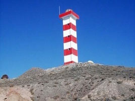
| MX 90 |
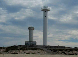
Punta Arena de la Ventana (Las Arenas)
latitude 24° 3' 9.8" N longitude 109° 49' 43" W
Located 70 km southeast of La Paz overlooking the Cerralvo Channel. The lighthouse appears to be about 1.5 km from the nearest main road and is probably accessible by 4WD. As you can see, there are actually 2 lights here, an old one (date unknown) and a new one built in 2009. ARLHS # MEX-122
Photo courtesy Wilton Hart [panoramio] |
|
| MX 91 |
Islote de la Reina |
Located on a rocky islet just off the northern tip of Isla Cerralvo. ARLHS # MEX-113 |
| MX 92 |
Punta Prieta (La Paz)
latitude 24° 13' 13.8" N longitude 110° 18' 43.6" W |
Punta Prieta lies about 25 km north of La Paz, and this is the light guiding vessels to the harbor approach. The lighthouse is surrounded by a Pemex petroleum facility. Located on the point of the cape. photo ARLHS # MEX-127 |
| MX 93 |
Punta Lobos |
Located on the sharp northeastern tip of Isla Carmen, a large island off Puerto Escondito. Probably accessible only by boat. |
| MX 94 |
Muleje (Mulege, Punta El Sombrerito)
latitude 26° 54' 5.3" N longitude 111° 57' 13.1" W
Located at Punta El Sombrerito atop a large rock marking the entrance to the harbor. photo
Photo courtesy Alejandro Lopez Ceja [skyscrapercity] |
|
| MX 95 |
Cabo Virgenes |
Located on a rugged promontory about 15 km north of Santa Rosalia. ARLHS # MEX-024 |
| MX 96 |
Punta Arenas (Baha de Los Ángeles)
latitude 28° 57' 21.3" N longitude 113° 32' 34.1" W
Located at the end of a sand spit partially sheltering the waterfront of Bahía de Los Angeles, a small resort town.
Photo courtesy nbonzey [Flickr] |
|
| MX 97 |
| San Felipe
latitude 31° 1' 36.7" N longitude 114° 49' 44.8" W
Located on a headland in the town of San Felipe. ARLHS # MEX-072
Photo courtesy Caroline & John [webshots] |
Sonora
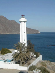
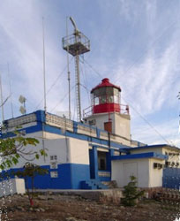
| MX 98 |
Puerto Peñasco
latitude 31° 18' 7.7" N longitude 113° 32' 49.2" W
Puerto Peñasco is at the northern end of the Sea of Cortés, accessible by a 1-hour drive via paved road (hwy 8) from Sonoita at the U.S. border. Located on a hill above the harbor of Puerto Peñasco. ARLHS # MEX-046
Photo courtesy mpr529 [Flickr] |
|
| MX 99 |
| Cabo Tepoca
The cape shelters the Bahía Tepoca, an anchorage about 130 km southeast of Puerto Peñasco and a few miles south of the village of Puerto Lobos. The site is a popular goal of 4WD expeditions. Located on a bluff at the point of the cape. ARLHS # MEX-104
Photo courtesy Alejandro Lopez Ceja [skyscrapercity] |
| MX 100 |
Cabo Haro |
Located high on the point of the cape, which projects into the Sea of Cortés about 5 km south of Guaymas. The intervening territory is quite rugged, so reaching the site requires 4WD and a local guide. ARLHS # MEX-023 |
| MX 101 |
Isla Pajaros (Guaymas)
Isla Pajaros is a fishhook-shaped island lying across the entrance to the harbor of Guaymas. Located on the southwestern tip of the island, marking the entrance to the harbor. ARLHS # MEX-011
Photo courtesy Alejandro Lopez Ceja [skyscrapercity] |
|
| MX 102 |
Yavaros (Bahía de Yavaros) |
Yavaros is a small port in southern portion Sonora, about 12 km south of Huatabampo. Located on a sandy ridge on the west side of the entrance to the Bahía de Yavaros. |
Sinaloa & Nayarit
| MX 103 |
Punta Piaxtla |
Located on a rocky headland about 50 km north of Mazatlán ARLHS # MEX-126 |
| MX 104 |
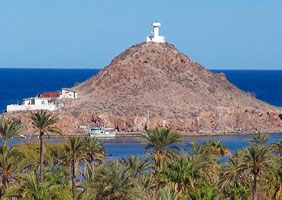
Isla Crestón (El Faro de Mazatlán)
One of the best known Mexican lighthouses, this is often said to be the second highest in the world, claims that unfortunately do not hold true even for Middle America -- Lovers Leap in Jamaica, Chacachacare in Trinidad, and Cap Moule á Chique in St. Lucia are all much higher). Located south of downtown at the summit of the rock.
Photo courtesy Alejandro Lopez Ceja [skyscrapercity] |
|
|
|
| MX 105 |
| San Blas
San Blas is the principal port of Nayarit. The lighthouse is located on a peninsula on the west side of the harbor entrance; boat rides are available from the town waterfront. ARLHS # MEX-095
Photo courtesy meeshyklahr [webshots] |
Jalisco & Colima
| MX 106 |
Puerto Vallarta Anterior |
Located just off the main street in downtown Puerto Vallarta. ARLHS # MEX-186 |
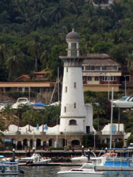
| MX 107 |
Puerto Vallarta Posterior
Located 140 m northeast of the front light. ARLHS # MEX-187
Photo courtesy ZIGfil [Flickr] |
|
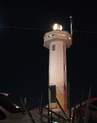
| MX 108 |
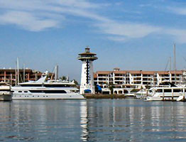
| Puerto Vallarta Marina
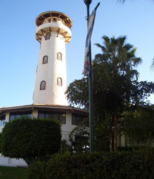
This building is actually a restaurant built to look like a lighthouse.
Photo courtesy H. Marc Lewis |
| MX 109 |
Cabo Corrientes (Jalisco) |
The cape, about 65 km west of Puerto Vallarta, is one of the most important headlands of Mexico's Pacific coast. ARLHS # MEX-022 |
| MX 110 |
Punta Farallón |
Punta Farallón is in southern Jalisco about 135 km southeast of Cabo Corrientes. ARLHS # MEX-124 |
| MX 111 |
Punta Campos (Manzanillo) |
Located atop the point south southeast of Manzanillo, marking the eastern entrance to the Bahía de Manzanillo. Accessible by 4WD, although the access road is narrow and winding. ARLHS # MEX-052 |
Michoacán (Costa Alegre)
| MX 112 |
Punta San Telmo (Faro de Bucerias) |
The beach below the lighthouse is a well known turtle sanctuary. Located on a high bluff in western Michoacán, about 1.5 km off the coast road (hwy 200). Accessible from the beach via a long stairway. ARLHS # MEX-062 |
| MX 113 |
Caleta de Campos (Bufadero Bluff)
The lighthouse is accessible from the coastal road (hwy 200) in Caleta de Campos, about 50 km west of Playa Azul.
Photo courtesy David Haggard (Kansas City, MO) [Flickr] |
|
| MX 114 |
Lázaro Cárdenas |
Named for a former President of Mexico, Lázaro Cárdenas is a newly developed seaport in southernmost Michoacán. Located in an industrial area on the west side of the harbor entrance. ARLHS # MEX-142 |
Guerrero
| MX 115 |
Punta Garrobo (Zihuatenejo) |
Located on the point, a very sharp promontory at the east side of the entrance to the Bahía de Zihuatenejo. Accessible by walking trails from the Playa las Gatas, a beach on the east side of the town; boats run frequently to Playa las Gatas from the pier downtown. ARLHS # MEX-054 |
| MX 116 |
Punta Norte de la Roqueta |
Located on the north point of the Isla de la Roqueta marking the entrance to the channel to the port of Acapulco. ARLHS # MEX-143 |
| MX 117 |
Isla de la Roqueta (Acapulco) |
Located at the highest point of the island, at the southwestern entrance to the Bahía de Acapulco |
| MX 118 |
Acapulco Bay
This light is not listed as an aid to navigation, so probably is best classified as a faux light.
Photo courtesy RB Glasson [Flickr] |
|
| MX 119 |
| Acamama
Located on a headland near the beach called Playa Ventura, in eastern Guerrero, about 20 km southeast of Copala. Playa Ventura ARLHS # MEX-185
Photo courtesy Bill Masterson [webshots] |
| MX 120 |
Punta Maldonado
Punta Maldonado is the southernmost town of Guerrero, and the lighthouse stands on or close to the boundary between Guerrero and Oaxaca. Accessible by road. ARLHS # MEX-060
Photo courtesy cutemike1 [Flickr] |
|
Oaxaca
| MX 121 |
| Puerto Escondido
Located at the edge of the cliffs at the western entrance to the harbor. ARLHS # MEX-044
Photo courtesy mexicotrip [webshots] |
| MX 122 |
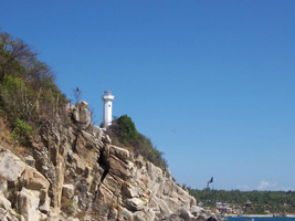
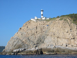
Puerto Ángel |
Puerto Ángel is at the southernmost point of Oaxaca, at the western end of the Gulf of Tehuantepec. ARLHS # MEX-119 |
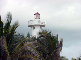
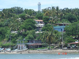
| MX 123 |
Huatulco
Huatulco is about halfway between Puerto Angel and Salina Cruz on the Gulf of Tehuantepec. The lighthouse stands above a frequently visited "blowhole" where the sea shoots upward through a narrow opening. Located on a rocky point at the southwestern entrance to the Bahía de Huatulco. ARLHS # MEX-106
Photo courtesy dropintheriver [webshots] |
|
| MX 124 |
Morro Ayutla |
Morro Ayutla is a promontory projecting from an otherwise featureless coast about 40 km east northeast of Huatulco. The light is in a remote area, perhaps accessible only by boat. ARLHS # MEX-038 |
| MX 125 |
Morro de Salinas (Faro de Cortés) |
The lighthouse is named for the explorer and conqueror Hernán Cortés, who arrived here in 1527. Located atop a bluff (morro) on the west side of the harbor of Salina Cruz. ARLHS # MEX-039 |
| MX 126 |
San Francisco del Mar |
The lighthouse guides vessels toward the entrance to the Laguna Inferior, a large lagoon. Located on a long sand spit about 40 km east of Salina Cruz. ARLHS # MEX-073 |
| MX 127 |
San Dionisio del Mar |
Located at the point of a spit projecting into the Laguna Inferior about 10 km south of San Dionisio del Mar. Accessible only by boat. ARLHS # MEX-130 |
| MX 128 |
La Chichi |
Located just off the barrier beach about 35 km east of the entrance to the Laguna Inferior. Best accessed by boat across the lagoon. ARLHS # MEX-114 |
| MX 129 |
La Soledad |
Located just off the barrier beach about 30 km west of Paredón. Best accessed by boat across the lagoon. ARLHS # MEX-115 |
Chiapas
| MX 130 |
Puerto Arista |
The keeper's house now houses a Navy post, due to increased drug smuggling along the coast. In older and quieter times the keeper also served as the town mailman. Located on the main street in Puerto Arista. ARLHS # MEX-042 |
| MX 131 |
Barra San Juan |
Located behind the beach about 40 km southeast of Puerto Arista. ARLHS # MEX-099 |
| MX 132 |
Puerto Madero |
Located on the west side of the harbor entrance of Puerto Madero. ARLHS # MEX-045 |
|
|


 California