|
This page currently shows the documentation of the Lighthouses between Columbia and Venezuela. Thus it covers the countries of Guyana, Suriname and French Guiana. In addition, the pictures below are linked to the relevant photo on the web (thus making available to you a higher resolution picture.) I am very grateful to Russ Rowlett at the University of North Carolina for his excellent Lighthouse Directory for the outline. Each lighthouse is linked to (in our editorial opinion) the best reference site for that light. LHdirectory I would like to include directions on how to get to these lights. If you know such data, could you eMail me and I'll post it here (with your choice of attribution.) MailMe |
|
| GU 1 |
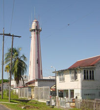
Georgetown
latitude 6° 49' 25.2" N longitude 58° 9' 51.4" W
The lighthouse is a tourist attraction, so should be easy to find. It's at the end of Water Street, marking the mouth of the Demerara River. ARLHS # GUY-001
Photo courtesy courtesy Jane Peters [Flickr] |
|
| GU 2 |
Clonbrook |
Located on the Atlantic coast about 15 miles southeast of Georgetown. |
| GU 3 |
New Amsterdam |
Located in the city, it's on the east bank of the Berbice River about 4 miles south of the mouth of the river. |
| SU 1 |
Nickerie Rivier |
This light is on the west side of the entrance to the River, near Nieuw Nickerie (NW Suriname) ARLHS # SUR-005 |
| SU 2 |
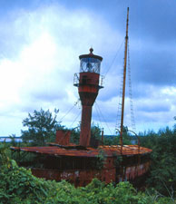
Lighthship Suriname Rivier (Suriname 1)
This lightship is beached in Nieuw Amsterdam, on the east bank of the Surname River (opposite Paramarbo). ARLHS # SUR-004
Photo courtesy courtesy Vanessa Decort [Flickr] |
|
|
|
| SU 3 |
Lighthship Suriname 2 |
It currently is an abandoned hulk on the Surname River near Paramaribo. photo |
| SU 4 |
Lighthship Suriname 3 |
It lies next to the boat listed above. |
| SU 5 |
Paramaribo Range Front |
ARLHS # SUR-002 |
| SU 6 |
Paramaribo Range Rear |
ARLHS # SUR-003 |
|
|
| SU 7 |
Hoek Galibi (Maroni River)
latitude 5° 44' 49.4" N longitude 53° 59' 5.8" W |
Located just off Hoek (Cape) Galibi on the west side of the entrance to the Maroni River, which forms the boundary between Suriname and French Guiana. Accessible only by boat. ARLHS # SUR-001 |
| FG 1 |
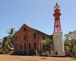
Île Royale
As you can see in the photo, the light is within the grounds of a former penal colony. The island is accessible from Cayenne, and guided tours are available. ARLHS # FRG-002
Photo courtesy courtesy Larry Halff [Flickr] |
|
| FG 2 |
Kourou (Tour Dreyfus)
latitude 5° 9' 34" N longitude 52° 37' 35.6" W |
This light is located on Pointe des Roches, the promontory on the west side of the Kourou River (at the entrance in Kourou). photo |
| FG 3 |
L'Enfant Perdu |
The lighthouse was deactivated in favor of a buoy in 1968. After many protests from mariners, the tower was reactivated with an automated, solar-powered lamp in 1989. Located on a rocky islet about 11 km north of Cayenne. ARLHS # FRG-001 |
| FG 4 |
Fort Cépérou
latitude 4° 56' 15.6" N longitude 52° 20' 13.4" W |
Located on a hill behind Fort Cépérou, overlooking the harbor of Cayenne. ARLHS # FRG-004 |
|
|
 Colombia