|
This page shows the documentation of the Lighthouses of Southeastern Italy. Some of the photos below are available on webshots, some of the are on Flickr (and are reproduced with permission) and you can always click on the light to go to its specific (larger resolution) copy. Each lighthouse is linked to (in our editorial opinion) the best reference site for that light. I would like to include directions on how to get to these lights. If you know such data, could you eMail me and I'll post it here (with your choice of attribution.) me There has been significant usage of the Lighthouse Directory prepared by Russ Rowlett (UNC). LHDirectory Lighthouse coordinates are via Lighthouse Depot Database . My thanks to them for providing this basis for understanding. database |
|
Cambria East Coast (Golfo di Taranto)
| IT 150 |
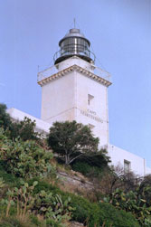
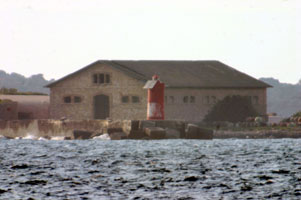
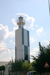
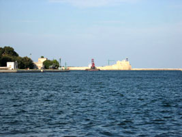
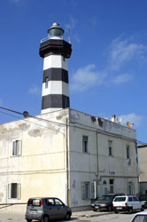
Capo Spartivento
latitude 37° 55' 32.8" N longitude 16° 3' 38.8" E
This famous lighthouse is the southernmost lighthouse of the Italian mainland. Note that there is another Capo Spartivento, with another famous lighthouse, at the southern tip of Sardinia. IT 85
Located on the E90 coastal highway about 1.2 km southwest of Gelati. ARLHS # ITA-043
Photo courtesy sun_strak [webshots] |
|
| IT 151 |
| Punta Stilo
latitude 38° 26' 50.6" N longitude 16° 34' 39.4" E
Located on the E90 coastal highway at Monasterace. (E 2108) ARLHS # ITA-147
Photo courtesy Alex Trabas [ListOfLights] |
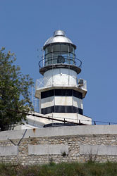
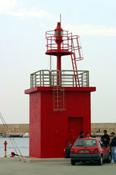
| IT 152 |
Capo Rizzuto
latitude 38° 53' 42.5" N longitude 17° 5' 34.1" E
Located atop a sharp promontory, at the end of the Via Faro in the town of Capo Rizzuto. (E 2112) ARLHS # ITA-033
Photo courtesy Alex Trabas [ListOfLights] |
|
| IT 153 |
| Capo Colonna
latitude 39° 1' 43.2" N longitude 17° 12' 20.2" E
Located on the point of the cape, at the end of the SP 49 highway about 11 km southeast of Crotone. ARLHS # ITA-010
Photo courtesy Pasquale Salerno [Flickr] |
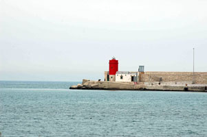
| IT 154 |
Crotone Molo Sanità
latitude 39° 5' 45.7" N longitude 17° 7' 32.9" E
Located on the west quay of the older harbor at Crotone. As you can see, there is parking on the quay. (E 2123)
Photo courtesy Alex Trabas [ListOfLights] |
|
| IT 155 |
| Crotone Molo Vecchio
latitude 39° 5' 32.5" N longitude 17° 7' 33.2" E
Located at the end of the breakwater of the older harbor at Crotone. Accessible by walking the pier. (E 2122)
Photo courtesy Alex Trabas [ListOfLights] |
| IT 156 |
Punta Alice
This lighthouse marks the western entrance to the Golfo di Taranto. Located on a prominent but low cape about 5 km north of Cirò Marina. (E 2128)
Photo courtesy Alex Trabas [ListOfLights] |
|
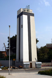
| IT 157 |
Capo Trionto |
The light is still listed by NGA, but Trabas omits it, suggesting strongly that it has been deactivated. Located on a cape on the west side of the Golfo di Taranto in Mirto. photo ARLHS # ITA-191 |
| IT 158 |
Punta Coscio (Marina Laghi di Sibari)
latitude 39° 43' 49.8" N longitude 16° 30' 21.6" E
This light is part of a large marina complex dredged from low-lying land. Located about 2.5 km northwest of Punta Coscio and the same distance southeast of the town of Marina di Sibari. (E 2130.5) ARLHS # ITA-310
Photo courtesy Alex Trabas [ListOfLights] |
|
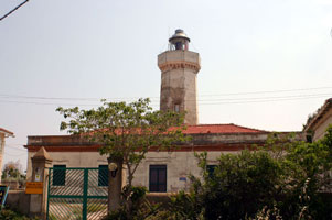
| IT 225 |
Scanzano Jonico (Torre della Scanzana, Torre Faro)
latitude 40° 15' 26.6" N longitude 16° 44' 45.2" E |
The tower is the Torre della Scanzana, built on orders of the Spanish viceroy in the mid 16th century. Located on the coast at Scanzano Jonico. Apparently the light tower gallery has been removed. ARLHS # ITA-318 |
Taranto Area
| IT 226 |
Isolotto San Paulo
latitude 40° 26' 12.8" N longitude 17° 10' 46.1" E
The north breakwater is interrupted by several islands, the Isole Cheradi, and ends with a short section projecting southeastward from the Isolotto San Paulo. (E 2138)
Photo courtesy Alex Trabas [ListOfLights] |
|
| IT 226J |
| Mare Piccolo Posteriore
latitude 40° 29' 50.2" N longitude 17° 14' 33.6" E
The Mare Piccolo is an inner harbor of Taranto, connected to the Mar Grande by a narrow inlet. Located on the Via della Pineta on the north shore of the Mare Piccolo northeast of Taranto. (E 2152.1)
Photo courtesy Alex Trabas [ListOfLights] |
| IT 226M |
Taranto Porto Mercantile East Mole
This light marks the east side of the entrance to the Mare Piccolo from the Mar Grande. Located at the end of a short pier on the Taranto waterfront. (E 2146)
Photo courtesy Alex Trabas [ListOfLights] |
|
| IT 227 |
| Mar Grande Anteriore (Secca della Tarantola)
latitude 40° 26' 53.5" N longitude 17° 13' 40.4" E
This range guides ships outbound from Taranto across the Mar Grande. Located on a small artificial island off the southeast side of the Mar Grande. Accessible only by boat. ARLHS # ITA-316
Photo courtesy Alex Trabas [liteslist] |
| IT 228 |
Mar Grande Posteriore (Casa Gigante)
Located on the waterfront on the north side of Capo San Vito.(Note that there is also a Capo San Vito on Sicily.) IT 174 ARLHS # ITA-099
Photo courtesy Alex Trabas [liteslist] |
|
| IT 229 |
| Diga di San Vito
latitude 40° 25' 46.6" N longitude 17° 11' 40.2" E
Located at the end of the south breakwater of Taranto. (E 2134) ARLHS # ITA-200
Photo courtesy Alex Trabas [ListOfLights] |
|
|
| IT 230 |
Capo San Vito
latitude 40° 24' 42.2" N longitude 17° 12' 12.8" E
Capo San Vito encloses the south side of the Mar Grande, Taranto's harbor. Located on the point of the cape at the end of the Via del Faro. Note: there is another Capo San Vito lighthouse, more properly known as San Vito lo Capo, Sicily. * ARLHS # ITA-040
Photo courtesy Alex tnt [webshots] |
|
| IT 231 |
Torre dell'Ovo
latitude 40° 17' 59.2" N longitude 17° 30' 16.8" E |
Located on a promontory about 2.5 km southeast of Librari and 32 km southeast of Taranto. ARLHS # ITA-322 |
Southern Salento Peninsula
| IT 231A |
Porto Cesareo Anteriore
latitude 40° 15' 31.3" N longitude 17° 53' 28.2" E
Located on the waterfront in Porto Cesareo. (E 2164) ARLHS # ITA-237
Photo courtesy Alex Trabas [ListOfLights] |
|
| IT 231P |
| Porto Cesareo Posteriore
latitude 40° 15' 53" N longitude 17° 54' 17.1" E
Located in Porto Cesareo ½ mi north northeast of the front light. (E 2164.1) ARLHS # ITA-238
Photo courtesy Alex Trabas [ListOfLights] |
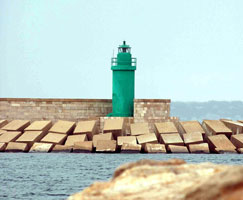
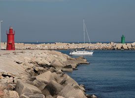
| IT 231S |
Gallipoli Molo di Sottoflutto
latitude 40° 3' 40.5" N longitude 17° 59' 0.3" E
Located at the end of the short inner mole of Gallipoli.
Photo courtesy Eros Blanco [Flickr] |
|
| IT 231T |
| Gallipoli Molo di Tramontana
latitude 40° 3' 30.1" N longitude 17° 58' 58.6" E
Located at the end of the breakwater mole of Gallipoli (E 2172)
Photo courtesy Klaus Potschien [ListOfLights] |
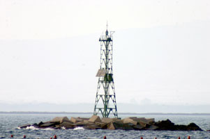
| IT 232 |
Isola Sant'Andrea
latitude 40° 2' 50" N longitude 17° 56' 44.4" E
The Isola Sant'Andrea is a flat, sandy island about 2.5 km off the waterfront of Gallipoli. Located on the southwestern edge of the island. Accessible only by boat. (E 2168) ARLHS # ITA-084
Photo courtesy Alex Trabas [ListOfLights] |
|
| IT 233 |
| Torre San Giovanni
The tower was built by Carlos V of Spain, one of a number of towers built in the late 1500s to guard against attacks by the Saracens. Located in the village of Torre San Giovanni, about 6 km southwest of Ugento. ARLHS # ITA-171
Photo courtesy Frederico Lucchini [Flickr] |
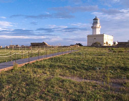
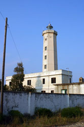
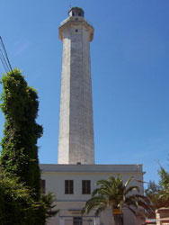
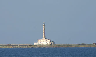
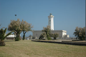
| IT 234 |
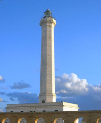
Capo Santa Maria di Leuca
Capo Santa Maria di Leuca is the tip of the Salento peninsula, so this historic lighthouse marks the western entrance to the Strait of Otranto and the Adriatic Sea. Located at the tip of the cape in Leuca. ARLHS # ITA-039
Photo courtesy boadiceafairy [Flickr] |
|
| IT 235 |
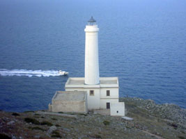
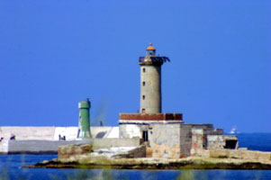
| Capo d'Otranto (1867) (Palascia)
latitude 40° 6' 25.1" N longitude 18° 31' 10.6" E
This is Italy's easternmost lighthouse, marking the narrowest point of the Strait of Otranto, the mouth of the Adriatic Sea. Located on the point of the cape, about 5 km southeast of Otranto. ARLHS # ITA-137
Photo courtesy Egido Ferrighi [fari] |
| IT 236 |
Capo d'Otranto (new) (Palascia)
The light is located up the hill from the old light, thus is 25 meters taller. (E 2178) ARLHS # ITA-315
Photo courtesy Egidio Ferrighi [ListOfLights] |
|
| IT 237 |
| Torre Sant'Andrea (Missipezza)
latitude 40° 15' 18.7" N longitude 18° 26' 41.6" E
The lighthouse warns ships away from shoals nearby. Located about 2.5 km south of Torre dell'Orso. (E 2188) ARLHS # ITA-170
Photo courtesy Klaus Potschien [ListOfLights] |
| IT 238 |
San Cataldo di Lecce
latitude 40° 22' 38" N longitude 18° 18' 40.1" E
Located just off a popular beach at Punta San Cataldo di Lecce, about 12 km east of Lecce.
Photo courtesy Cyril N. Alberga |
|
Brindisi Area
| IT 239 |
| Le Pedagne (Isolotto Traversa)
latitude 40° 39' 27.8" N longitude 17° 59' 27.6" E
Located on a reef off the entrance to Brindisi harbor, about 1.5 km outside the breakwaters. Accessible only by boat. (E 2196) ARLHS # ITA-175
Photo courtesy Alex Trabas [ListOfLights] |
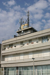
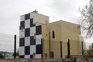
| IT 240 |
Brindisi (1984) (Monumento del Marinaio d'Italia)
The tower is part of the Monument to the Italian Sailor, built in 1933 during the Mussolini era. The navigational light was not added until 1984. Located in a park on the north side of the inner harbor of Brindisi. ARLHS # ITA-107
Photo courtesy Roberta [Flickr] |
|
|
|
| IT 241 |
| Brindisi (1400s) (Castello Aragonese)
latitude 40° 39' 19.4" N longitude 17° 58' 4.6" E
Located on an island which is now joined to the mainland by a causeway and serves as the anchor of the north breakwater of Brindisi harbor. ARLHS # ITA-314
Photo courtesy Roberta [Flickr] |
| IT 241C |
Brindisi Diga di Castello (North Inner Breakwater)
latitude 40° 39' 11.3" N longitude 17° 58' 7.9" E
Located at the end of the north inner breakwater of Brindisi, directly below the walls of the Castello a Mare. (E 2204)
Photo courtesy Alex Trabas [ListOfLights] |
|
| IT 241P |
| Brindisi Diga di Punta Riso (Diga di Punta Riso, North Breakwater)
latitude 40° 39' 46.6" N longitude 17° 59' 49" E
Located at the end of the long breakwater on the north side of Brindisi harbor. (E 2198)
Photo courtesy Alex Trabas [ListOfLights] |
| IT 242 |
Torre Canne (Punta Torre Canne)
Located on a point of land in the town of Torre Canne about 40 km northwest of Brindisi. ARLHS # ITA-150
Photo courtesy Massimo Stragapede [Flickr] |
|
| IT 243 |
| Monopoli (Molo Margherita)
Located at the end of the Molo Margherita, the traditional breakwater mole of Monopoli, at the south side of the entrance to the harbor. ARLHS # ITA-232
Photo courtesy Mathieu [Flickr] |
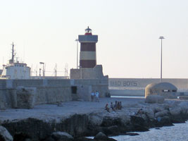
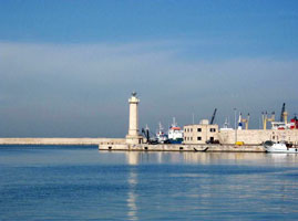
| IT 244 |
Bari Molo San Antonio
Located at the end of the Molo San Antonio, which encloses the old harbor, now the small boat harbor, on the east side of Bari. It is not known if the mole is walkable.
Photo courtesy Daniele [Flickr] |
|
| IT 245 |
| Bari Vecchio Molo Foraneo
Located at the end of the old east breakwater mole, which now extends into the center of the modern harbor of Bari. This mole does not appear to be walkable. (E 2238) ARLHS # ITA-312
Photo courtesy Alex Trabas [ListOfLights] |
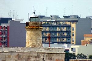
| IT 246 |
Bari Molo San Vito
latitude 41° 8' 0.1" N longitude 16° 51' 44.5" E |
Located at the end of the mole, which is just west of ferry terminals in Bari. photo ARLHS # ITA-311 |
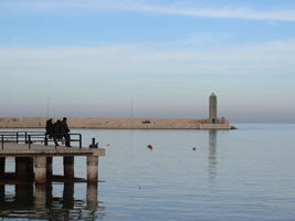
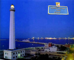
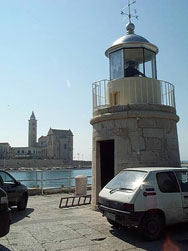
| IT 247 |
Bari (Punta San Cataldo)
latitude 41° 8' 20.8" N longitude 16° 50' 42.3" E
It guides ships to the harbor of Bari, the most important port of Puglia and the terminus for trans-Adriatic ferries. Located on Punta San Cataldo, at the base of the Molo San Cataldo, on the west side of the harbor of Bari. ARLHS # ITA-141
Photo courtesy Antonio Peca [webshots] |
|
Molfetta, Trani & Barletta
| IT 248 |
| Molfetta
latitude 41° 12' 29.8" N longitude 16° 33' 51.4" E
According to Faro di Han, the original lighthouse was replaced on a new location after fishermen following its light wrecked on the shore instead of finding the harbor. Located at the elbow of the Molo Santa Michel, which projects into the harbor at Molfetta. ARLHS # ITA-224
Photo courtesy Mario Conti [webshots] |
| IT 249 |
Molfetta Molo Foraneo
latitude 41° 12' 42.8" N longitude 16° 35' 28.6" E
Located at the end of the breakwater (the Molo Santa Michele) at Molfetta. (E 2252) ARLHS # ITA-317
Photo courtesy Klaus Potschien [ListOfLights] |
|
| IT 250 |
| Trani (Molo San Antonio)
latitude 41° 16' 53.3" N longitude 16° 25' 19.7" E
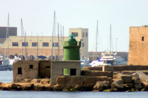
Located at the em>original end of the east breakwater, the Molo San Antonio, at Trani. ARLHS # ITA-321
Photo courtesy Antonio Peca [webshots] |
| IT 251 |
Trani Molo San Antonio Interno
latitude 41° 16' 57.5" N longitude 16° 25' 21.3" E
Located at the end of the extension of the east breakwater.
Photo courtesy Francesco Rotondo [Flickr] |
|
| IT 252 |
Trani Braccio di San Nicola
latitude 41° 17' 5.2" N longitude 16° 25' 25.9" E |
Located at the end of the main (west) breakwater. |
| IT 253 |
Barletta (1807) (Molo di Tramontana)
Located near the base of the Molo di Tramontana, the east breakwater of Barletta. ARLHS # ITA-313
Photo courtesy Antonio Peca [webshots] |
|
| IT 254 |
| Barletta (1959) (Molo di Tramontana)
latitude 41° 19' 50.1" N longitude 16° 17' 26.4" E
Located near the end of the Molo di Tramontana, the east breakwater of Barletta. (E 2264) ARLHS # ITA-228
Photo courtesy Alex Trabas [ListOfLights] |
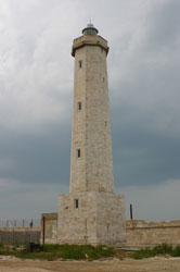
Gargano Peninsula
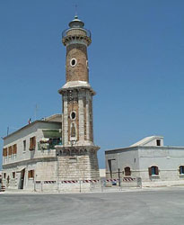
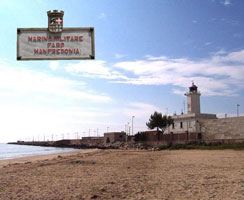
| IT 255 |
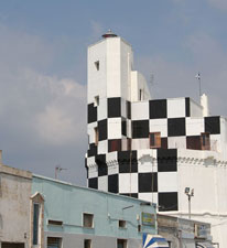
Manfredonia
The lighthouse was heavily damaged in 1943, during World War II, and was rebuilt after the war. Located near the base of the east mole of Manfredonia, a wide mole that includes a street and has a public beach on the east side. ARLHS # ITA-099
Photo courtesy Antonio Peca [webshots] |
|
| IT 256 |
| Torre Preposti
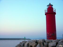
Located on a steep slope at Testa del Gargano, the easternmost point of the peninsula. Accessible by twisting mountain roads. (E 2286) ARLHS # ITA-169
Photo courtesy Alex Trabas [ListOfLights] |
| IT 257 |
Vieste
This is one of the most important lighthouses of the Adriatic, warning ships away from the Gargano Peninsula. Located on a small island, the Isola Sant'Eufemia, just off the waterfront of Vieste, at the northeastern tip of the peninsula. Accessible only by boat. ARLHS # ITA-090
Photo courtesy Roberto Ferrari [Flickr] |
|
| IT 258 |
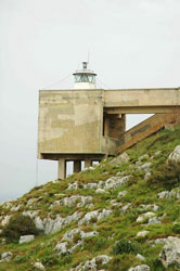
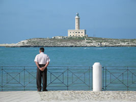
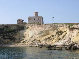
Isola Pianosa |
This building and the keeper's house have been damaged by storms that sometimes sweep over the island. Located about 22 km east northeast of the other islands of the group. Accessible only by boat. Note: there is another, better known Isola Pianosa in the Tuscan Islands off the west coast of Italy. IT 52 |
| IT 259 |
Isola Capraia (Punta del Trattoio)
The uninhabited island of Capraia is north of San Nicola, separated by a channel about 800 m wide. Accessible only by boat. ARLHS # ITA-207
Photo courtesy cirnad3 [webshots] |
|
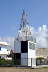
| IT 260 |
Isola San Domino (Punta del Diavolo) |
Located at the southwestern point of the island, marking the safe passage south of the island group. |
| IT 261 |
Termoli
latitude 42° 10' 15.8" N longitude 14° 42' 51.5" E
Located near the waterfront in Termoli. (E 2303) ARLHS # ITA-167
Photo courtesy Alex Trabas [ListOfLights] |
|
| IT 262 |
| Punta Penna
latitude 42° 10' 15.9" N longitude 14° 42' 51.5" E
The original lighthouse was nearly destroyed by retreating German troops in 1944. The ruins were demolished in 1946, and the new lighthouse was built on the design of architect Olindo Tarcione. Located on a prominent cape about 7 km north of Vasto. (E 2306) ARLHS # ITA-138
Photo courtesy Alex Trabas [ListOfLights] |
| IT 263 |
Ortona Molo Nord
Located on the Via del Porto at the base of the north mole in Ortona. (E 2312) ARLHS # ITA-108
Photo courtesy Alex Trabas [ListOfLights] |
|
|
|
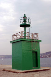
 Northeast Italy
 Southwest Italy
