|
This page shows the documentation of the Lighthouses of Northwestern Italy. Some of the photos below are available on webshots, some of the are on Flickr (and are reproduced with permission) and you can almost always click on the light to go to its specific (larger resolution) copy. Each lighthouse is linked to (in our editorial opinion) the best reference site for that light. I would like to include directions on how to get to these lights. If you know such data, could you eMail me and I'll post it here (with your choice of attribution.) mailme There has been significant usage of the Lighthouse Directory prepared by Russ Rowlett (UNC). My thanks to him for providing this basis for understanding. lhDirectory |
|
Western Liguria (Riviera di Ponente)
| IT 1 |
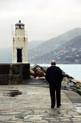
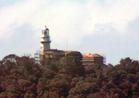
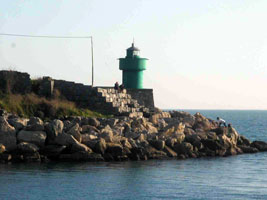
Capo dell'Arma (Punta Verde)
Not far east of San Remo, this lighthouse marks a prominent cape. Located on the point of the cape about 3 km southwest of Arma di Taggia. Not to be confused with Capo dell'Armi on the Strait of Messina. IT 149 (E 1152) ARLHS # ITA-013
Photo courtesy Alex Trabas [ListOfLights] |
|
| IT 2 |
| Imperia (Porto Maurizio)
Located about 150 m from the end of the breakwater (south) mole of Porto Maurizio in the town of Imperia. (E 1156) ARLHS # ITA-118
Photo courtesy Henry [henry-photo] |
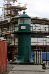
| IT 2R |
Imperia Molo di Ponete
A new light on the west Breakwater Mole. Can be seen behind the light above. (E 1157)
Photo courtesy Henry [henry-photo] |
|
| IT 4 |
Oneglia Molo di Ponente
latitude 43° 53' 6" N longitude 8° 2' 27.8" E
Located at the end of the short west mole at Oneglia on the east side of Imperia. You can see the light below in the background. (E 1164)
Photo courtesy Alex Trabas [ListOfLights] |
|
| IT 5 |
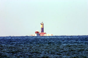
| Oneglia Molo di Levante
latitude 43° 53' 0.2" N longitude 8° 2' 25.8" E
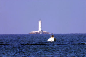
Located at the end of the Oneglia breakwater on the east side of Imperia. It's pretty invisible at this resolution, but the Imperia light is visible just in front of the spectator's feet. IT 2 (E 1162)
Photo courtesy Alex Trabas [l] |
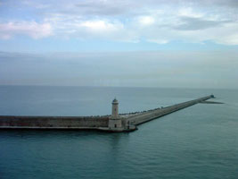
| IT 6 |
Capo Mele
latitude 43° 57' 19.4" N longitude 8° 10' 21" E
This handsome and historic lighthouse is built at the western entrance to the Golfo di Genova. Located above the point of the cape, on the northeast side of Andora.
Photo courtesy nouadhibou [webshots] |
|
| IT 7 |
| Capo di Vado (Vado Ligure)
latitude 44° 15' 28.8" N longitude 8° 27' 9.4" E
Capo di Vado is an prominent cape about 40 km west of Genova. Located on the SP1 coastal highway about 1.5 km south of Vado Ligure. (E 1172) ARLHS # ITA-017
Photo courtesy Captain Theo [ListOfLights] |
Genova (Genoa)
| IT 8 |
Voltri Breakwater
latitude 44° 24' 57.2" N longitude 8° 46' 11.6" E
Voltri is a modern commercial harbor developed about 11 km west of Genova. Located at the west end of the detached breakwater at Voltri. Accessible only by boat. (E 1202)
Photo courtesy Captain Theo [ListOfLights] |
|
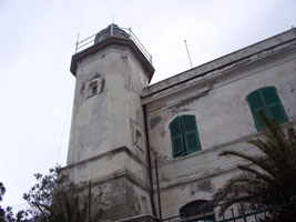
| IT 9 |
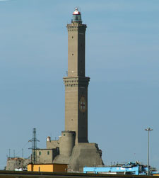
| Genova , La Lanterna di ... (1543)
Located on the Via al Largo della Lanterna, within walking distance of the ferry terminal in downtown Genoa. ARLHS # ITA-177
Photo courtesy Paolo C [Flickr] |
| IT 10 |
Molo Duca di Galliera
Located at the end of the breakwater on the south side of the entrance to the old harbor of Genova. The pier is not walkable, but there is a boat service that carries fishermen to the end of the pier. (E 1219)
Photo courtesy Egidio Ferrighi [ListOfLights] |
|
| IT 11 |
| Molo Vecchio
The original lighthouse was much taller, with a focal plane height of 69 ft, it was replaced by a short tower in 1909, but it's not clear if that is also the present tower. Located on the Molo Vecchio (Old Mole), a major commercial pier on the east side of Genova's old harbor. (E 1226)
Photo courtesy Alex Trabas [ListOfLights] |
| IT 12 |
Punta Vagno
Standing on the mainland, this lighthouse guides ships approaching the eastern entrance to the harbor of Genova. Located near the foot of the Via Piave on the east side of downtown Genoa. (E 1230) ARLHS # ITA-151
Photo courtesy Alex Trabas [ListOfLights] |
|
Portofino Area (Riviera di Levante)
| IT 13 |
| Camogli
latitude 44° 21' 33.1" N longitude 9° 8' 30.3" E
Located at the end of the breakwater at Camogli; accessible by walking the pier.
Photo courtesy confusedvision [Flickr] |
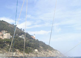
| IT 14 |
Portofino
latitude 44° 18' 6.9" N longitude 9° 12' 50.6" E
The famous resort town of Portofino is located behind the shelter of a steep promontory, with this lighthouse on the point. The light station is accessible by a popular walk of about 1200 m from the town.
Photo courtesy newpn2000 [Flickr] |
|
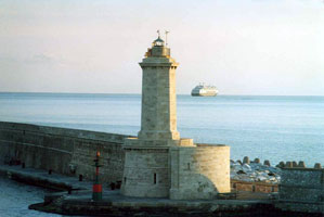
| IT 15 |
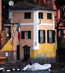
| Portofino Entrance
The light is mounted on a bracket on the side of a 3-story waterfront building. Located on the Calata Marconi in Portofino. (E 1246)
Photo courtesy Alex Trabas [ListOfLights] |
| IT 16 |
Rapallo
latitude 44° 20' 35.2" N longitude 9° 14' 4.7" E
Located at a right-angle bend in the main breakwater of Rapallo, the Calata Andrea Doria. (E 1255)
Photo courtesy Alex Trabas [ListOfLights] |
|
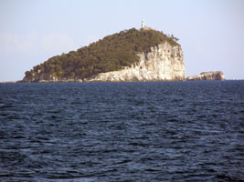
La Spezia
| IT 17 |
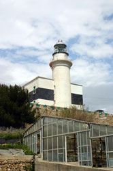
| Isola del Tino (1840) (Faro San Venerio)
latitude 44° 1' 35.3" N longitude 9° 50' 58.2" E
The Isola del Tino is a wedge-shaped island off the western entrance to the Golfo della Spezia, the harbor of La Spezia. The light station is perched high atop the wedge facing the Ligurian Sea. Accessible only by boat. The site is a military reservation and is generally closed, but it is open each year on September 10, the festival of San Venerio. (E 1262) ARLHS # ITA-058
Photo courtesy Egidio Ferrighi [ListOfLights] |
|
|
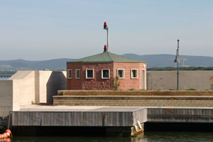
| IT 20 |
Pegazzano (La Spezia Entrance Range Rear)
Located on a slope above the inner harbor of La Spezia. ARLHS # ITA-287
Photo courtesy PhotoEgido Ferrighi [fari] |
|
| IT 21 |
| La Spezia Molo Italia
Located at the end of the Molo Italia on the waterfront of downtown La Spezia, marking the entrance to the traditional inner harbor.
Photo courtesy Pinco Pallo [Flickr] |
| IT 22 |
La Spezia Diga Foranea Estremità Est (Rada di La Spezia)
Located at the east end of the outer breakwater (diga foranea) of La Spezia just off Punta Santa Teresa south of Muggiano, marking the gap between the breakwater and the shore. Accessible only by boat. (E 1270)
Photo courtesy Alex Trabas [ListOfLights] |
|
| IT 23 |
| Punta Santa Teresa
Located on the point 800 m south of Muggiano, opposite the end of the outer breakwater of La Spezia.
Photo courtesy Egido Ferrighi [fari] |
Northern Tuscano
| IT 24 |
Marina di Carrara
Marina di Carrara is the port serving the famous Carrara quarries, which produce some of the world's finest marble. The docks and breakwater are crowded with marble waiting to be shipped. Located on the west side of the waterfront in Marina di Carrara. ARLHS # ITA-100
Photo courtesy Egido Ferrighi [cyberlites] |
|
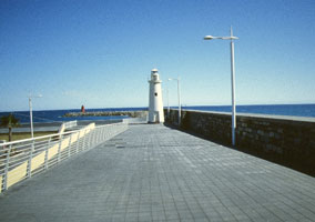
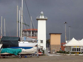
| IT 25 |
| Viareggio
latitude 43° 51' 51.1" N longitude 10° 14' 35.5" E
Viareggio is a small port about 20 km northwest of Pisa. Located near the foot of the south mole on the waterfront of Viareggio, at the north corner of the harbor adjacent to the Burlamacca canal. ARLHS # ITA-173
Photo courtesy Egido Ferrighi [cyberlites] |
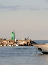
| IT 26 |
Viareggio Nuova Diga (New Breakwater)
latitude 43° 51' 28.1" N longitude 10° 14' 13.6" E
Located near the foot of the breakwater enclosing the harbor of Viareggio, about 600 m southwest of the older lighthouse. ARLHS # ITA-292
Photo courtesy Daniela Giannecchini [Flickr] |
|
| IT 27 |
| Secche della Meloria North End
This lighthouse is located 9 km northwest of the Torre della Meloria (next entry) and 14 km northwest of Livorno. Accessible only by boat. (E 1347) ARLHS # ITA-258
Photo courtesy Alex Trabas [ListOfLights] |
| IT 28 |
Secche della Meloria (1709) (Torre della Meloria) |
The Secche della Meloria is a large and very dangerous shoal extending to the northwest of Livorno. The first tower was built by Genoa, which controlled this coast until a decisive naval battle in 1284, within sight of the shoal, established Pisa's independence. A second tower was built in 1598, and the third was ordered in 1709 by Cosimo III de' Medici, Grand Duke of Tuscany. However, it is not clear whether any of these towers actually carried a light. Located on the shoal about 6 km west of Livorno. Accessible only by boat. ARLHS # ITA-290 |
| IT 29 |
Secche della Meloria (194?) (South End)
Located on the shoal a short distance southeast of the Torre della Meloria. Accessible only by boat. (E 1348)
Photo courtesy Alex Trabas [ListOfLights] |
|
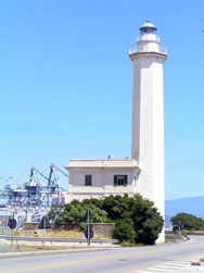
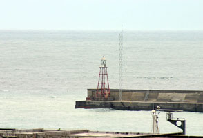
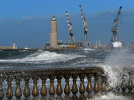
| IT 30 |
| Livorno Diga Marzocco
Located at the end of the Marzocco breakwater on the north side of Livorno's traditional harbor. (E 1360) ARLHS # ITA-284
Photo courtesy Alex Trabas [liteslist] |
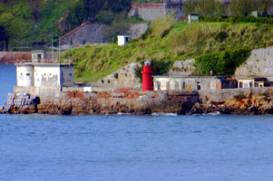
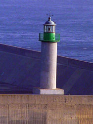
| IT 31 |
Livorno Diga Curvilinea North
Located at the north end of the Diga Curvilinea, where the breakwater joins the straight Diga Meloria. The active light is the little one, the large one is turned off. Accessible only by boat (the breakwater does not connect to shore). ARLHS # ITA-283
Photo courtesy Egido Ferrighi [fari] |
|
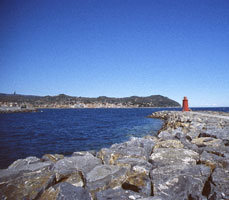
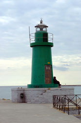
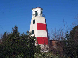
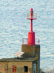
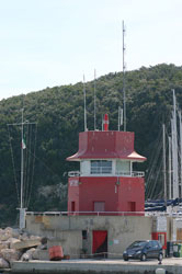
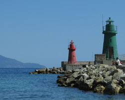
| IT 31S |
| Livorno Diga Curvilinea South
Located at the south end of the Diga Curvilinea, the curved breakwater protecting the harbor of Livorno.
Photo courtesy TR Bennet [webshots] |
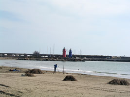
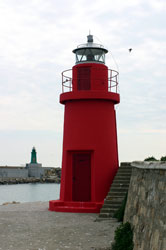
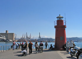
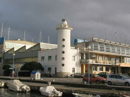
| IT 32 |
Livorno
This lighthouse is a copy of a famous tower built in 1304 and tragically destroyed during World War II. Located on the Livorno waterfront opposite the harbor entrance. ARLHS # ITA-097
Photo courtesy paolofal [webshots] |
|
|
|
| IT 33 |
Vada (Torre del Faro di Vada) |
Built in 1279, this tower served both defensive and navigational purposes. It's history as a lighthouse is poorly known, but a modern light was installed on the tower in 1867. Located in Vada, a town about 25 km south of Livorno. |
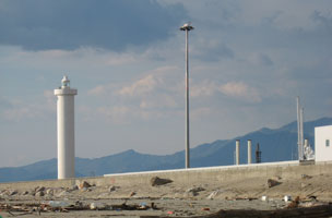
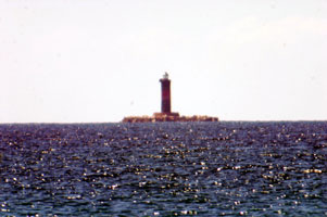
| IT 34 |
Secche di Vada
latitude 43° 19' 12.4" N longitude 10° 21' 51" E
This waveswept light is located on a shoal about 8 km west southwest of Vada. The original light was a pile lighthouse similar to the one built around the same time on Secche della Meloria (see above). Accessible only by boat. original (E 1384) ARLHS # ITA-164
Photo courtesy Alex Trabas [ListOfLights] |
|
Southern Tuscana
| IT 35 |
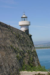
| Piombino (La Rocchetta)
Piombino, located at the end of a blunt peninsula jutting out of the Tuscan coast, is the ferry port for Elba.
Photo courtesy anares67 [Flickr] |
| IT 36 |
Marina di Scarlino (Estrusca Marina) Port Office
Located at the end of the north mole at the Marina di Scarlino (formerly the Etrusca Marina), a recreational boat harbor at Portiglioni. (E 1462)
Photo courtesy Alex Trabas [ListOfLights] |
|
| IT 37 |
| Punta Ala
latitude 42° 48' 27.4" N longitude 10° 44' 9.6" E
The lighthouse (probably the marina office) is at the end of the short north mole of the marina. (E 1466)
Photo courtesy Alex Trabas [ListOfLights] |
| IT 40 |
Talamone
latitude 42° 33' 5" N longitude 11° 8' 1" E
The present lighthouse is a copy of the original, which was heavily damaged in World War II. Located at the end of the Via dei Mille, at the tip of a sharp promontory sheltering the harbor of Talamone. ARLHS # ITA-166
Photo courtesy Paolo Cardoni [Flickr] |
|
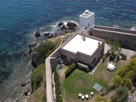
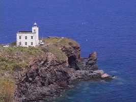
| IT 41 |
| Punta Lividonia
This lighthouse marks the northwestern tip of Monte Argentario, a mountainous almost-island connected tenuously to the mainland by sandbars and a causeway. Located on the spectacular coastal road, the Via Panoramica, about 2.5 km northwest of the town of Monte Argentario. ARLHS # ITA-134
Photo courtesy Egido Ferrighi [fari] |
| IT 42 |
Porto Ercole (Forte della Rocca)
This lighthouse stands on the southeastern tip of Monte Argentario. Located at the end of the Via della Rocca in Porto Ercole. (E 1500)
Photo courtesy Alex Trabas [ListOfLights] |
|
Arcipelago Toscano (Tuscan Islands)
| IT 43 |
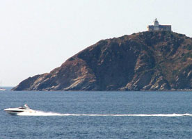
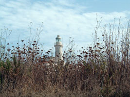
| Punta del Ferraione
The original light was on a mast rising from the keeper's house. Located at the end of a peninsula sheltering the harbor of Porto di Capraia. ARLHS # ITA-127
Photo courtesy Sergio Thor [webshots] |
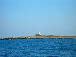
| IT 45 |
Scoglietto
latitude 42° 49' 43.1" N longitude 10° 19' 51.4" E
This little lighthouse stands atop a small islet about 1 km north of Portoferraio. Accessible only by boat, but passengers arriving on ferries to Portoferraio have an excellent view.
Photo courtesy Stefano [Flickr] |
|
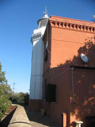
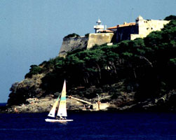
| IT 46 |
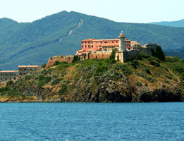
| Forte Stella
latitude 42° 48' 58.7" N longitude 10° 20' 2" E
The lighthouse is built on a northern rampart of Forte Falcone, a fortress built in the 16th century by Cosimo I de' Medici; the star-shaped fort is known locally as Forte Stella. ARLHS # ITA-083
Photo courtesy Martin Hapl [Flickr] |
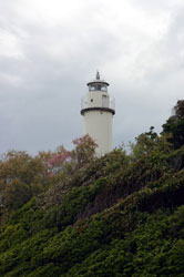
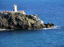
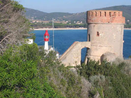
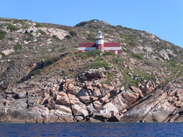
| IT 47 |
Palmaiola
Palmaiola is a small, very steep island in the Piombino Channel about 4 km east of Cavo, Elba, and 8 km southwest of Piombino on the mainland. Located at the highest point of the island. Accessible only by boat; there are distant views from the northeastern coast of Elba and from ferries crossing the strait.
Photo courtesy Daniel Witting [Flickr] |
|
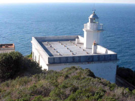
| IT 48 |
| Capo Focardo
The lighthouse is built just inside the high walls of the fort, making it difficult to get a good photo. Located on a promontory at the south side of the entrance to the harbor of Porto Azzurro (Longone) near the southeastern corner of Elba. ARLHS # ITA-022
Photo courtesy Konstantin Milenkovic [Flickr] |
| IT 49 |
Marina di Campo
Located on the hillside above the foot of the breakwater at Campo on the south coast of Elba. ARLHS # ITA-285
Photo courtesy Egido Ferrighi [fari] |
|
| IT 50 |
Monte Porro
latitude 42° 43' 40" N longitude 10° 14' 14.4" E |
Located atop a steep promontory at the western entrance to the Golfo di Campo, about 2.5 km south of Campo. ARLHS # ITA-295 |
| IT 51 |
Punta Polveraia
latitude 42° 47' 39.5" N longitude 10° 6' 37.1" E
This lighthouse marks the northwestern tip of Elba in a rather wild natural area. Located at the end of Via del Faro about 2 km west of Patresi. Accessible by a twisting mountain road. ARLHS # ITA-140
Photo courtesy Egido Ferrighi [fari] |
|
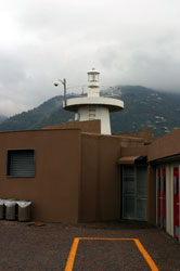
| IT 52 |
| Pianosa
For many decades it has been the site of Italy's most secure prison, where the dons of the Mafia and other high-risk inmates are imprisoned. Special permission is required to visit the island, although once there the lighthouse appears to be accessible. Located on the east side of the island.
Photo courtesy Francesca (persaperstrada74) [Flickr] |
| IT 53 |
Scoglio d'Africa |
The original light was a pile lighthouse, presumably similar to the Secche della Meloria and Secche di Vada lights. Scoglio d'Africa is a notoriously dangerous rock about 30 km due south of Pianosa. Accessible only by boat. ARLHS # ITA-160 |
| IT 54 |
Formiche di Grosseto
Formiche (ants) is a term Mediterranean sailors like to use for isolated rocks in the sea. Located on a small rocky islet about 20 km due south of Castiglione della Pescaia and a similar distance north of Giglio. Accessible only by boat. ARLHS # ITA-203
Photo courtesy BluMania [Flickr] |
|
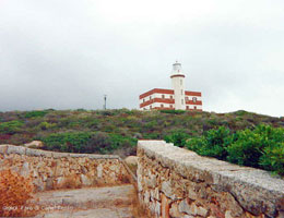
| IT 55 |
| Giglio Porto Molo di Levante (East Mole)
latitude 42° 21' 39.5" N longitude 10° 55' 16.4" E
The first mole light at Giglio Porto was built in 1865; by the 1930s there were lights on both moles. Located on the east mole of Giglio Porto. Accessible by walking the mole; there are also excellent views from ferries arriving at the harbor. ARLHS # ITA-204 |
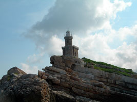
| IT 57 |
Punta Fenaio
latitude 42° 23' 17.9" N longitude 10° 52' 51.9" E
Located on the northern tip of Giglio. It is not clear whether there is land access to the station. ARLHS # ITA-246
Photo courtesy Paolo Cardoni [Luoghi] |
|
| IT 58 |
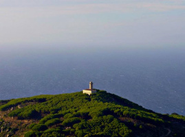
| Giglio (Faro Antico)
latitude 42° 22' 33" N longitude 10° 53' 51.6" E
This lighthouse was built as the sole light for the island, but its focal plane of 1017 ft was much too high; the light was often obscured by low clouds or fog. The condition of this historic building is described as ottime (optimal). Privately owned, it is currently for sale. Located on the heights somewhere in the north central part of Giglio. ARLHS # ITA-281
Photo courtesy Cecilia [Flickr] |
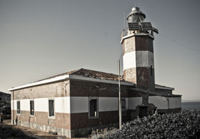
| IT 59 |
Capel Rosso (Punta di Capel Rosso)
latitude 42° 19' 15.4" N longitude 10° 55' 10.6" E
Located on the southern tip of Giglio; accessible by a hiking trail from the end of a national park road. ARLHS # ITA-126
Photo courtesy Federicochi [Flickr] |
|
| IT 60 |
| Giannutri (Punta Rosso)
Giannutri is a small island about 10 km south of the Monte Argentario peninsula and the same distance southeast of Giglio. The island is accessible by ferries from Porto Santo Stefano on Monte Argentario. The lighthouse is said to have been built in 1861, but it stood empty for many years. Located on Punta Rosso, the south point of the island, apparently accessible by road and perhaps a short hike.
Photo courtesy Bizio [Flickr] |
|
|
 Southern France