|
This page shows the documentation of the Lighthouses of Northeastern Italy. Some of the photos below are available on webshots, some of the are on Flickr (and are reproduced with permission) and you can always click on the light to go to its specific (larger resolution) copy. Each lighthouse is linked to (in our editorial opinion) the best reference site for that light. I would like to include directions on how to get to these lights. If you know such data, could you eMail me and I'll post it here (with your choice of attribution.) mailme There has been significant usage of the Lighthouse Directory prepared by Russ Rowlett (UNC). LHdirectory Lighthouse coordinates are via Lighthouse Depot Database. My thanks to them for providing this basis for understanding. LHdepot |
|
Marche
| IT 264 |
San Benedetto del Tronto
latitude 42° 57' 9.6" N longitude 13° 53' 9.8" E
Located on the Via dei Tigli on the waterfront of San Benedetto del Tronto. ARLHS # ITA-154
Photo courtesy pizzodisevo [Flickr] |
|
| IT 265 |
| Pedaso
latitude 43° 5' 27.9" N longitude 13° 50' 42.2" E
The old tower was pulled down after being heavily damaged by German troops in World War II. Located on a bluff about 1.5 km south of Pedaso. (E 2336) ARLHS # ITA-112
Photo courtesy Alex Trabas [ListOfLights] |
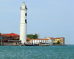
| IT 266 |
Civitanova Marche (Chiesa del Christo Re)
latitude 43° 18' 38.5" N longitude 13° 43' 41.8" E
Civitanova Marche -- the "new city" of Marche -- is a resort town and yachting center about 30 km southeast of Ancona. Located just off the waterfront of Civitanova Marche. ARLHS # ITA-323
Photo courtesy 4everYoung [Flickr] |
|
| IT 267 |
| Civitanova Molo Nord
latitude 43° 18' 50.9" N longitude 13° 43' 59" E
Located at the end of the mole on the north side of the harbor of Civitanova Marche; accessible by walking the mole.
Photo courtesy giastmc [Flickr] |
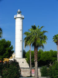
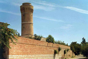
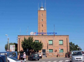
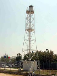
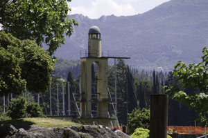
| IT 268 |
Colle Cappucini (1860) (Ancona)
latitude 43° 37' 24.2" N longitude 13° 30' 52.1" E
Ordered by Pope Pius IX, this fortified light station was one of the last public works built in the Marche by the papal administration. Located on the Via del Faro at the edge of the Parco Monte Cardeto, overlooking the harbor.
Photo courtesy Egido Ferrighi [fari] |
|
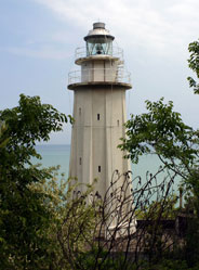
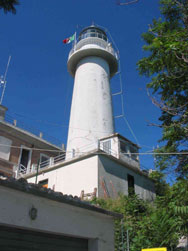
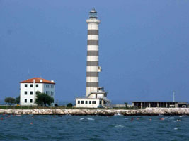
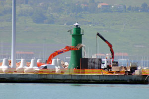
| IT 269 |
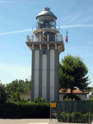
| Colle Cappucini (1965) (Ancona)
latitude 43° 37' 22.3" N longitude 13° 30' 56.7" E
A 1° Fresnel lens is in use. Located just north of the historic lighthouse. ARLHS # ITA-104
Photo courtesy Egido Ferrighi [fari] |
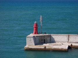
| IT 270 |
Ancona Molo Foraneo Nord
latitude 43° 37' 31.8" N longitude 13° 29' 38.2" E
Located at the end of the north breakwater of Ancona. Older photos will show alternate red and white stripes on this lite.
Photo courtesy vicky1572 [webshots] |
|
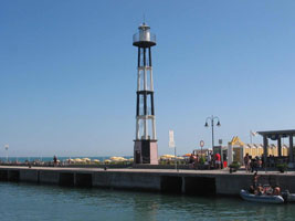
| IT 272 |
Senigallia (Molo di Levante)
latitude 43° 43' 11.5" N longitude 13° 13' 15" E
Located near the end of the east breakwater (Molo di Levante) at Senigallia. Accessible by a street, the Banchina di Levante, along the mole.
Photo courtesy Egido Ferrighi [fari] |
|
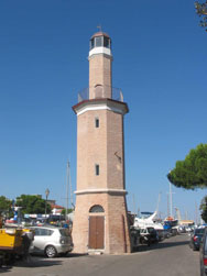
| IT 273 |
| Fano
The original light was a 52 ft round tower centered on a small 1-story building. Located one block south of the waterfront in Fano. ARLHS # ITA-065
Photo courtesy Egido Ferrighi [fari] |
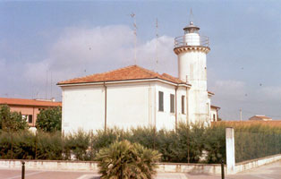
| IT 274 |
Monte di San Bartolo (Pesaro)
latitude 43° 55' 23.2" N longitude 12° 52' 52.6" E
Located on a steep slope above the Adriatic about 2 km northwest of Pesaro. ARLHS # ITA-106
Photo courtesy Egido Ferrighi [fari] |
|
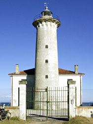
| IT 275 |
| Cattolica (Gabbice)
latitude 43° 58' 15.1" N longitude 12° 45' 4.1" E
The original light was a small wooden tower. Located at the end of the east mole in Gabbice, the town in Marche that adjoins Cattolica in Emilia-Romagna. Accessible by walking the mole. ARLHS # ITA-052
Photo courtesy Egido Ferrighi [fari] |
|
|
Emilia-Romagna
| IT 276 |
Rimini
The original lighthouse was heavily damaged and was torn down after the war and replaced by the present tower, which is taller but more slender. Located on the Via Destra del Porto on the east side of the harbor channel in Rimini. ARLHS # ITA-152
Photo courtesy Gary Buchan [Flickr] |
|
| IT 277 |

| Cesenatico
latitude 44° 12' 27.4" N longitude 12° 24' 14.1" E
The original light was an 18 m square tower. Located on the east side of the harbor channel in Cesenatico. ARLHS # ITA-052
Photo courtesy Marizio Mauri [Flickr] |
| IT 278 |
Cervia
latitude 44° 16' 0.8" N longitude 12° 21' 28.8" E
Located adjacent to the harbor of Cervia. ARLHS # ITA-196
Photo courtesy Egido Ferrighi [fari] |
|
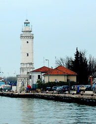
| IT 279 |
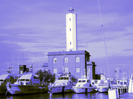
| Marina di Ravenna (Porto Corsini)
latitude 44° 29' 31" N longitude 12° 17' 3.1" E
The original light was 24 m tall; it was rebuilt after being heavily damaged during World War II. Located on the south side of the harbor, about 10 km northeast of Ravenna. ARLHS # ITA-075
Photo courtesy newpn [Flickr] |
| IT 280 |
Porto Garibaldi
latitude 44° 40' 33" N longitude 12° 14' 40.3" E
The original light was on a mast. Located on the north side of the harbor entrance at Porto Garibaldi, about 30 km north of Ravenna. ARLHS # ITA-116
Photo courtesy Egido Ferrighi [fari] |
|
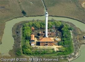
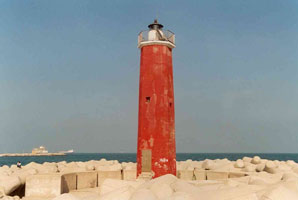
| IT 281 |
| Goro (Porto di Po di Goro)
latitude 44° 47' 28.4" N longitude 12° 23' 47.1" E
This historic lighthouse marks the entrance to the Po River. The Po has formed a large delta extending into the Adriatic; the lighthouse is on the south side of this delta in a area of dunes and marshes. Ruins of an older lighthouse can be found several hundred meters west of the present lighthouse. Located on the south side of the river's southernmost entrance, which forms part of the boundary between Emilia-Romagna and Veneto.
Photo courtesy Cristina Zanoni [Flickr] |
Veneto (the Venice Region)
| IT 282 |
Punta della Maestra
latitude 44° 58' 6.6" N longitude 12° 31' 46.5" E
Punta della Maestra is the tip of the delta of the Po River and the location of the river's largest mouth, the Po della Pila. The lighthouse is on the north side of the entrance to the Po della Pila, about 3.5 km east of Pila. Accessible only by boat. ARLHS # ITA-129
Photo courtesy marinas.com [Marinas.com] |
|
| IT 283 |
| Porto Levante (Albarella)
latitude 45° 4' 9.4" N longitude 12° 20' 41.2" E
Unusually decorative for a water tower, the present light is actually located in Isola Albarella, a resort community on the north side of the Po di Levante, the northernmost mouth of the Po River.
Photo courtesy Egido Ferrighi [fari] |
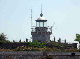
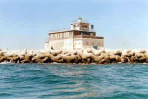
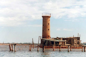
| IT 284 |
Chioggia (1868) (Forte San Felice)
latitude 45° 13' 47.8" N longitude 12° 17' 24.3" E
Built in the 18th century, the Forte San Felice guards the entrance. The fort is in dilapidated condition and is not open to the public. Located on the south side of the Porto di Chioggia entrance. fort
Photo courtesy Egido Ferrighi [fari] |
|
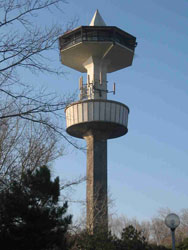
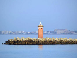
| IT 285 |
| Chioggia (1996)
latitude 45° 13' 46.9" N longitude 12° 17' 51.3" E
Located west of Forte San Felice, an area accessible by road from Sottomarina, the beachfront community of Chioggia.
Photo courtesy Egido Ferrighi [fari] |
|
|
| IT 286 |
Malamocco Molo Sud (Lanterna di Malamocco)
latitude 45° 19' 52.6" N longitude 12° 20' 11.1" E
The Porto di Malamocco is the central one of three entrances to the Laguna Veneta. Located at the end of the south mole at Porto di Malamocco. ARLHS # ITA-221
Photo courtesy Egido Ferrighi [fari] |
|
| IT 287 |
| Malamocco Molo Nord
The original light had a focal plane of 12.5 m. Located at the end of the north mole at Porto di Malamocco. ARLHS # ITA-220
Photo courtesy Egido Ferrighi [fari] |
| IT 288 |
Rocchetta
latitude 45° 20' 22" N longitude 12° 18' 40.1" E
This lighthouse marks the south end of the Lido, the barrier island that protects Venice from the Adriatic. Located on the north side of the Porto di Malamocco in Alberoni. ARLHS # ITA-255
Photo courtesy Egido Ferrighi [fari] |
|
| IT 289 |
| Alberoni
latitude 45° 20' 59.8" N longitude 12° 19' 30.6" E
It is possible that this light was in use for only a short period in the late 1800s. Located on the heights of Alberoni, perhaps 1/2 mi northeast of the Faro di Rocchetta.
Photo courtesy Egido Ferrighi [fari] |
| IT 290 |
Spignon
It appears to have guided ships between Venice and the Porto di Malamocco. Located on a sandbar in the Laguna Veneta, west of Alberoni and northwest of the Porto di Malamocco. Accessible only by boat.
Photo courtesy Egido Ferrighi [fari] |
|
| IT 291 |
| Lido Molo Sud (Faro San Nicolò)
Located at the end of the south mole at the Porto di Lido; this mole is about 2.5 km longitude Accessible only by boat. ARLHS # ITA-239
Photo courtesy CS Archibald [webshots] |
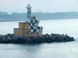
| IT 292 |
Lido Molo Nord (La Pagoda)
latitude 45° 25' 21.8" N longitude 12° 26' 12.3" E
Located at the end of the north mole at the Porto di Lido; this mole is only about 1/4 mi long.
Photo courtesy Ivan Štekovic [panoramio] |
|
| IT 293 |
| Lido Fanale Anteriore (Entrance Range Front)
latitude 45° 26' 16.7" N longitude 12° 23' 24.2" E
Located about ¼ mi north of the northern tip of Lido di Venezia. Accessible only by boat.
Photo courtesy Egido Ferrighi [fari] |
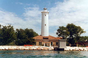
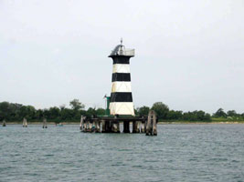
| IT 294 |
Isola di Murano (Entrance Range Rear)
latitude 45° 27' 9.8" N longitude 12° 21' 16.6" E
The lighthouse has a distinct lean in the seaward direction. Located 3.2 km west northwest of the front light, on the southeast side of the Isola di Murano, near the foot of the Calle Giuseppe Briati. Murano is part of the city of Venice and is accessible by waterbus from the central city. ARLHS # ITA-088
Photo courtesy Ethan Pease [webshots] |
|
| IT 295 |
| Porto Piave Vecchia
latitude 45° 28' 42.8" N longitude 12° 34' 59.8" E
The building at the base of the lighthouse is the harbor master's office for Venice. Located on the west side of the Sile River entrance, about 11 km east of the Porto di Lido. ARLHS # ITA-119
Photo courtesy Egido Ferrighi [fari] |
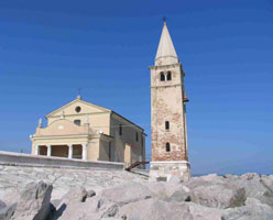
| IT 296 |
Caorle
latitude 45° 36' 0.1" N longitude 12° 53' 34.1" E
The light is mounted on a bracket about halfway up the tower. The tower is not attached to the church, the Chiesa della Madonna dell'Angelo. Located on a promontory on the waterfront of Caorle.
Photo courtesy Egido Ferrighi [fari] |
|
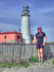
| IT 297 |
| Punta Tagliamento (Bibione)
latitude 45° 38' 10.6" N longitude 13° 5' 50.9" E
The light station is on the beach, very close to the sea; it appears to be endangered by storm surges or rising sea level. Until 1918 (assuming it had been built before then) this lighthouse marked the easternmost point of Italy; it overlooks the former Austrian frontier. Located on a promontory at the end of Via del Faro on the east side of Bibione. ARLHS # ITA-148
Photo courtesy Iguana Jo [Flickr] |
Friuli-Venezia Giulia
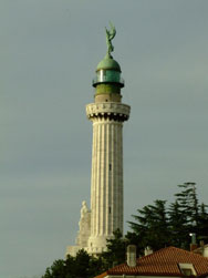
| IT 298 |
Vittoria
latitude 45° 40' 32.1" N longitude 13° 45' 25.2" E
It stands on the hill of Gretta, off the Strada del Friuli, about 1.2 mi north of the central city and waterfront.
Photo courtesy Cici Babin [Flickr] |
|
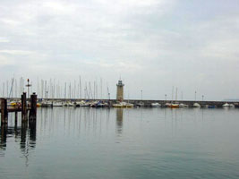
| IT 299 |
| Trieste Molo Foraneo (Trieste Breakwater South Head)
latitude 45° 39' 18.9" N longitude 13° 45' 44.7" E
Located at the south end of the detached breakwater protecting the harbor of Trieste. Accessible only by boat.
Photo courtesy Frabuleuse [Flickr] |
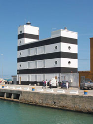
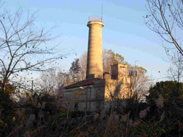
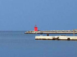
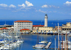
| IT 300 |
Trieste (Lanterna di Trieste, Molo Santa Teresa)
latitude 45° 38' 56.7" N longitude 13° 45' 21.8" E
According to a historical account, it replaced a lighthouse ordered by the Empress Maria Theresa that took 25 years to build (1744-1769). Much earlier, there was a Roman lighthouse in Trieste, and from the 7th century lights were shown from the tower of the chapel of San Nicolò. Located in the heart of the Trieste waterfront. account
Photo courtesy Dario Manzoni [Flickr © 2005] |
|
| IT 301 |
| Desanzano del Garda
latitude 45° 28' 15.4" N longitude 10° 32' 40.1" E
Located at the end of a breakwater mole at Desenzano del Garda, a town at the southwestern corner of the lake in Lombardia. Accessible by walking the mole. |
| IT 302 |
Riva del Garda
latitude 45° 49' 12" N longitude 10° 50' 60" E
May 30, 2011
Located at the end of a breakwater mole at Riva del Garda, a town at the northern corner of the lake in Lombardia. Accessible by walking the mole. |
|
|
|
 Northwest Italy


