|
Greece's continental boundaries are shaped like an inverted "U". This page covers those lights on the northern side of the Aegean Sea. Lights are numbered from Northwest to Northeast. You can almost always click on the light to go to it's specific (larger resolution) copy. Each lighthouse is linked to (in our editorial opinion) the best reference site for that light. I would like to include directions on how to get to these lights. If you know such data, could you eMail me and I'll post it here (with your choice of attribution.) mailme |
|
| GR 44 |
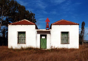
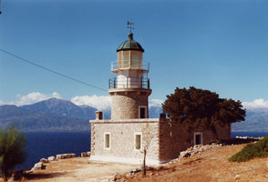
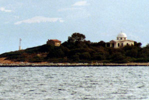
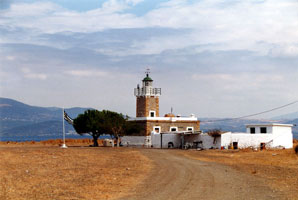
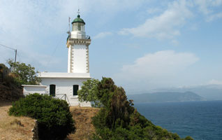
Aktio Range Front
latitude 38° 56' 39.8" N longitude 20° 45' 40.7" E
The range guides ships through the narrow entrance to the Gulf of Amvrakikos. The rear light is on a skeletal tower. Located on the beach on the south side of the entrance, in Aktio. (E 3804)
Photo courtesy Alex Trabas [ListOfLights] |
|
| GR 45 |
Akra Laskara |
ARLHS # GRE-172 |
| GR 46 |
Akra Akra (Stenon Prevezis) |
ARLHS # GRE-157 |
| GR 47 |
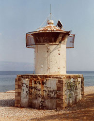
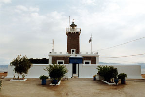
Koprenas (Gulf of Amvrakikos)
latitude 39° 1' 47.8" N longitude 21° 4' 31.4" E
Located at the end of a long, sandy spit projecting into the northeastern corner of the Gulf of Amvrakikos about 1.5 km south of Aliki. This site is very popular with birders. (E 3820) ARLHS # GRE-085
Photo courtesy Alex Trabas [ListOfLights] |
|
| GR 48 |
Akra Khondri |
ARLHS # GRE-169 |
| GR 49 |
Akra Kefali |
ARLHS # GRE-168 |
| GR 50 |
Akra Milika |
ARLHS # GRE-173 |
| GR 51 |
Oxiá (Gulf of Patraikos, Oxeía)
latitude 38° 16' 59.8" N longitude 21° 5' 59.5" E |
Oxiá is a small island at the north entrance to the Gulf of Patras, which leads to the Gulf of Corinth. Located at the southern tip of the island. Accessible only by boat, although transportation can be arranged from Astakos on the nearby mainland. ARLHS # GRE-101 |
| GR 52 |
Akra Rion |
ARLHS # GRE-180 |
| GR 53 |
Agios Sostis (Mesologi)
latitude 38° 19' 16" N longitude 21° 22' 29.9" E |
The island of Agios (Saint) Sostis lies on the north side of the Gulf of Patraikós in the entrance to the bay of Mesolóngi about 8 km southwest of the city of Mesolóngi. The only other structures on the small island are a ruined customshouse and the chapel of St. Sostis photo ARLHS # GRE-055 |
| GR 54 |
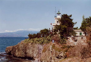
Antirio (Cape Antirio)
latitude 38° 19' 37.7" N longitude 21° 45' 56.4" E |
Cape Antirrion is a sharp promontory forming the north side of the Rio (Strait) Antirrion, the 1.9 km wide entrance to the Gulf of Corinth. Sultan Bayazet II built castles on both sides of the strait in 1500, as the Ottoman Empire was in the process of conquering western Greece from Venice. photo ARLHS # GRE-006 |
| GR 55 |
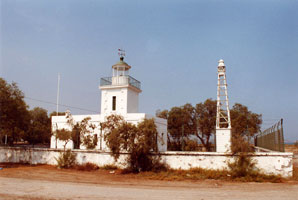
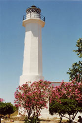
Nafpaktos
latitude 38° 23' 31.2" N longitude 21° 49' 43.3" E
Located on the east side of the harbor entrance at Nafpaktos, about 10 km northeast of Antirion. (E 3942) ARLHS # GRE-134
Photo courtesy Alex Trabas [ListOfLights] |
|
|
|
| GR 56 |
Akra Mornos |
ARLHS # GRE-174 |
| GR 57 |
Akra Andromakhi |
ARLHS # GRE-158 |
| GR 58 |
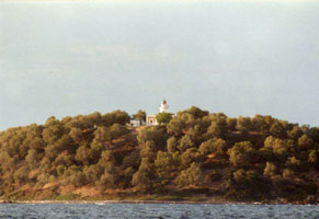
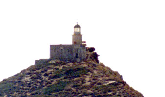
Apsifiá (Galaxidí, Agios Georgios)
latitude 38° 22' 56.6" N longitude 22° 24' 9.6" E
Located at the southern point of Apsifiá island, about 1.5 km east of Galaxidi. (E 3960) ARLHS # GRE-155
Photo courtesy Alex Trabas [ListOfLights] |
|
| GR 59 |
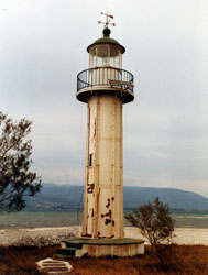
| Psaromyta (Gulf Of Corinth)
latitude 38° 22' 56.6" N longitude 22° 24' 9.6" E
Located on a prominent cape on the north side of the Gulf of Corinth, about 4 km southeast of Agios Nikolaos. According to Savas, the light is at the end of dirt road that intersects the main coastal highway 1.5 km southeast of Agios Nikolaos. 4WD recommended. (E 3956) ARLHS # GRE-114
Photo courtesy Alex Trabas [ListOfLights] |
| GR 60 |
Akra Karas |
ARLHS # GRE-166 |
| GR 61 |
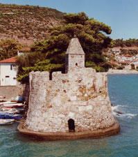
Agios Yeoryios (Hydra Island) |
Frommer's Greek Islands talks about a pristine pebble beach here, but doesn't mention a lighthouse. ARLHS # GRE-056 |
| GR 62 |
Agios Andreas |
There is a small marina and beach here, but no sign of a lighthouse at either. marina ARLHS # GRE-154 |
| GR 62R |
Ormos Oropou
latitude 38° 19' 40.1" N longitude 23° 48' 28.8" E
Located on the beach, just off the coastal road, on a prominent cape about 1.6 km northeast of Skala Oropou and due north of Athens. (E 4360)
Photo courtesy Alex Trabas [ListOfLights] |
|
| GR 63 |
| Avlida (Stenon Avlidhos, Akra Avlis)
latitude 38° 24' 34.5" N longitude 23° 37' 55.8" E
This lighthouse marks the southern entrance to the narrow strait separating Euboea from the mainland. (Avlida is on the mainland, but the municipality is part of the Euboea prefecture.) Located on the waterfront in Avlida. (E 4366) ARLHS # GRE-046
Photo courtesy Alex Trabas [ListOfLights] |
| GR 64 |
Kakokefali (Halkida)
latitude 38° 28' 36.1" N longitude 23° 36' 12.9" E
Located in Halkida, marking the northern entrance to the narrow strait separating Euboea from the mainland. (E 4378) ARLHS # GRE-075
Photo courtesy Alex Trabas [ListOfLights] |
|
|
|
| GR 65 |
| Atalanti
latitude 38° 41' 2.2" N longitude 23° 5' 25.6" E
Located on an islet off the northern tip of Atalanti, an island in the Gulf of Euboea about 3 km southeast of Livanates. (E 4412)
Photo courtesy Alex Trabas [ListOfLights] |
| GR 66 |
Arkitsa
latitude 38° 45' 18.6" N longitude 23° 2' 2.3" E
Located on Akra Arkitsa, a sharp cape projecting into the Notios Evvoikos Kolpós (Gulf of Euboea) at the town of Arkitsa. (E 4416) ARLHS # GRE-042
Photo courtesy Alex Trabas [ListOfLights] |
|
| GR 67 |
| Strogili (Evia Island)
latitude 38° 48' 29.4" N longitude 22° 49' 15.5" E
Located on a small island in the Gulf of Euboea off the western tip of the island of Euboea. (E 4420) ARLHS # GRE-124
Photo courtesy Alex Trabas [ListOfLights] |
| GR 68 |
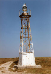
Anteros (Cape Chiliomili, Ákra Khiliomíli)
latitude 38° 51' 4.9" N longitude 22° 41' 47.3" E
This little lighthouse is a typical French tourelle, a type of prefabricated light installed in countries all over the world. Located on a sharp cape at the south side of the entrance to the Maliakos Kolpós, about 5 km north of Skarfia. (E 4424) ARLHS # GRE-057
Photo courtesy Alex Trabas [ListOfLights] |
|
| GR 69 |
| Vasilina (Cape Vasilina)
latitude 38° 52' 14.1" N longitude 22° 51' 2.4" E
This lighthouse marks the western entrance to the Oreon strait, which separates the northwestern end of Euboea from the mainland. Located on Akra Vasilina, a point of land projecting into the strait, about 5 km north of Agios Georgios (E 4432) ARLHS # GRE-129
Photo courtesy Alex Trabas [ListOfLights] |
| GR 70 |
Mandili (Karistos Island)
latitude 37° 56' 0.9" N longitude 24° 31' 28.2" E
Located atop an island off the southeastern tip of Euboea, marking the entrance to the Kolpós Petalion, the gulf separating southern Euboea from the Attic peninsula. (E 4451) ARLHS # GRE-094
Photo courtesy Alex Trabas [ListOfLights] |
|
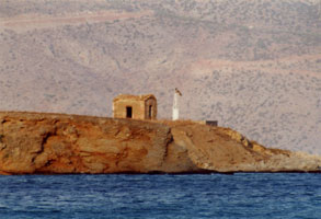
| GR 71 |
Argironisos (Argironisos Island)
latitude 39° 35.2" N longitude 23° 4' 32.4" E |
This lighthouse marks the eastern entrance to the Oreon strait, which separates the northwestern end of Euboea from the mainland. Located on an island about 3 km east of Agios Dimitrios on the mainland, and about 5 km northwest of Kanatadika on Euboea. photo ARLHS # GRE-041 |
| GR 72 |
Pontikonisi (Akra Artemision)
latitude 39° 2' 57.3" N longitude 23° 20' 18.2" E |
The light guides ships around Akra Artemision, the northernmost point of Euboea into the strait of Skiathou. Located on a small island about 2.5 km northeast of Akra Artemision. photo ARLHS # GRE-110 |
| GR 73 |
Trikeri (Gulf of Pagasitikos, Kavoulia)
latitude 39° 5' 48.7" N longitude 23° 3' 4" E
The lighthouse was built by French engineers for the Ottoman Empire; it became Greek when Thessalia (Thessaly) was ceded to Greece in 1881. It stands at the end of a long, hook-shaped peninsula that encloses the Pagasitikos Kolpós. Located on Akra Kavoulia, about 3 km west of Trikeri. (E 4442) ARLHS # GRE-128
Photo courtesy Alex Trabas [ListOfLights] |
|
| GR 74 |
| Akra Sipias
latitude 39° 10' 50.4" N longitude 23° 20' 56.4" E
Located on a prominent cape about 8 km northeast of Platania, marking the entrance to the strait between the mainland and the island of Skiathos. (E 4464)
Photo courtesy Alex Trabas [ListOfLights] |
| GR 75 |
Repi (Skiathos Island, Repion)
latitude 39° 8' 49" N longitude 23° 31' 44.4" E |
This light and Gourouni a deep water passage between the islands of Skíathos and Skópelos, used by coastwise shipping. Located on Répi, a small island off the east coast of Skíathos and about 4 km east southeast of Skíathos village. photo ARLHS # GRE-137 |
| GR 76 |
Guruni (Skopelos Island)
latitude 39° 12' 27.2" N longitude 23° 35' 35.3" E
This lighthouse is on the island of Skópelos, largest of the chain of islands off the coast of Thessaly known as the Voriai (Northern) Sporades. The lighthouse appears to be in excellent condition. The island is about 20 km long and has a population of about 5000. Located at the northwestern tip of the island, about 4 km northwest of Glossa. ARLHS # GRE-071
Photo courtesy Jennifer Wilkin [Flickr] |
|
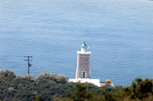
| GR 77 |
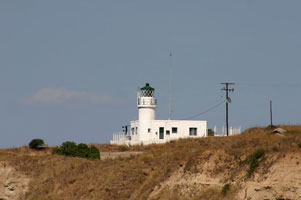
| Posidi (Cape Kasandra)
latitude 39° 57' 31.1" N longitude 23° 21' 45.6" E
There are three long, fingerlike peninsulas pointing into the Aegean in this region of Macedonia. This lighthouse is on the south side of the Kassandra peninsula, the westernmost of the three. Located about about 2 km southwest of Posidi. (E 4488) ARLHS # GRE-138
Photo courtesy Alex Trabas [ListOfLights] |
| GR 78 |
Akra Atheridha
Located on a prominent cape about 10 km southeast of Methoni. (E 4496)
Photo courtesy Alex Trabas [ListOfLights] |
|
| GR 79 |
| Megalou Emvolou (Karabournaki)
latitude 40° 30' 6.7" N longitude 22° 49' 2.3" E
This lighthouse stands on Akra Megalou Emvolou and marks the east side of the entrance to the bay of Thessaloníki at the extreme northwestern corner of the Aegean Sea. According to Savas, the area was part of a Hellenic Navy base and was closed to civilians, but it appears that this is no longer the case. Located on the cape, about 5 km northwest of Nea Mihaniona and about 15 km southwest across the bay from Thessaloníki. (E 4498) ARLHS # GRE-096
Photo courtesy Alex Trabas [ListOfLights] |
| GR 80 |
Axios (Kavoura)
latitude 40° 30' 40" N longitude 22° 44' 51.7" E
This lighthouse stands on an island off the delta of the Axios River and marks the west side of the entrance to the bay of Thessaloníki at the extreme northwestern corner of the Aegean Sea. (E 4497) ARLHS # GRE-047
Photo courtesy Alex Trabas [ListOfLights] |
|
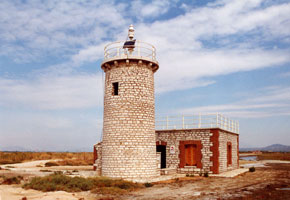
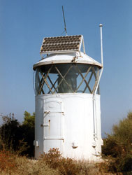
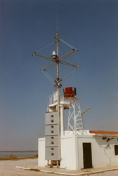
| GR 81 |
| Thessaloniki Harbor Office
latitude 40° 37' 53.1" N longitude 22° 56' 4.7" E
The light guides vessels entering the inner harbor of Thessaloniki, which is protected by a detached breakwater. Located at the end of Pier 1, the easternmost pier of the commericial harbor area. Accessible by walking or driving the pier. (E 4504)
Photo courtesy Alex Trabas [ListOfLights] |
| GR 82 |
Thasos East Breakwater Head |
ARLHS # GRE-188 |
| GR 83 |
Thasos West Breakwater Head |
ARLHS # GRE-189 |
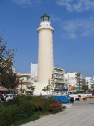
| GR 84 |
Alexandroupolis
latitude 40° 50' 36.6" N longitude 25° 52' 30.1" E
Alexandroupolis is the easternmost city of the Greek mainland, located about 15 km from the Turkish border. The city is relatively new; it was developed by the Ottoman Empire in the late 19th century and originally known as Dedeagatch. This handsome lighthouse is located right on the city-s waterfront boulevard at the base of the main quay, making it one of the most accessible of all Greek lighthouses. According to Savas, it was transferred to the Hellenic Maritime Museum in 1986 and is open to the public. ARLHS # GRE-005
Photo courtesy stefg74 [Flickr] |
|
| GR 85 |
| Akra Kara Orman (Kavala)
latitude 40° 55' 47.6" N longitude 24° 24' 47.2" E
Kavala, located on the mainland opposite the island of Thasos, is the principal port of eastern Macedonia. Located at the tip of a blunt peninsula that shelters the east side of the harbor of Kavala. (E 4540)
Photo courtesy Alex Trabas [ListOfLights] |
|
|
 Greece (Ionian Sea)