|
Greece's continental boundaries are shaped like an inverted "U". This page covers those lights facing the Ionian sea which is the westward side of the "U". Lights are numbered from the north to the south.
You can almost always click on the light to go to it's specific (larger resolution) copy. Each lighthouse is linked to (in our editorial opinion) the best reference site for that light. I would like to include directions on how to get to these lights. If you know such data, could you eMail me and I'll post it here (with your choice of attribution.) mailme |
|
| GR 1 |
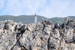
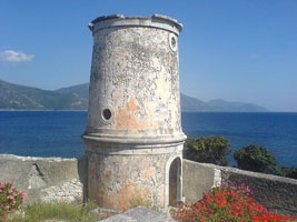
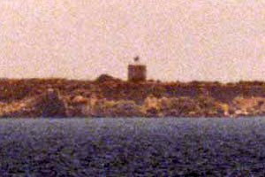
Kastri (Othonoi Island)
latitude 39° 51' 53.6" N longitude 19° 25' 45.2" E |
Othoni the westernmost Greek territory, is an island about 3.5 mi long and about 25 km northwest of Kérkyra. The island is accessible by ferry from the town of Kérkyra. Located on the northeastern point of the island. photo ARLHS # GRE-078 |
| GR 2 |
Nisis Proti |
The Pylos port limits are the lighthouse of 'Nissos Pylos' Island and Chelonike Island. ARLHS # GRE-190 |
| GR 3 |
Akra Arilla |
ARLHS # GRE-160 |
| GR 3K |
Akra Kosteri ARLHS # GRE-170
Photo courtesy Rich Schoeller [eMail] |
|
| GR 5 |
Akra Aikuterina (Kerkira) |
ARLHS # GRE-156 |
| GR 6 |
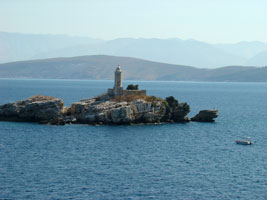
Peristeres (Rock Island)
latitude 39° 47' 33" N longitude 19° 57' 33.1" E
Located on a rocky islet off the northeastern tip of Kérkyra, marking the entrance to the channel between the Greek island and the Albanian mainland. ARLHS # GRE-179
Photo courtesy Ivan Šteković [panoramio] |
|
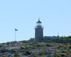
| GR 7 |
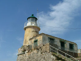
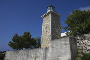
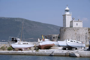
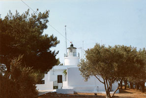
| Sideros (Corfu Island)
latitude 39° 37' 22.9" N longitude 19° 55' 46.1" E
The lighthouse was built by the British to light the way to their principal naval base in the Ionian Islands. It stands at the east end of the town of Kérkyra within the Venetian citadel, which withstood repeated sieges by the Turks. Note: there is another Faros Sidero on Kriti (Crete). CR 22 ARLHS # GRE-117
Photo courtesy Larry Myhre [Flickr] |
| GR 8 |
Levkimnis (Salternes)
Located on Akra Levkimnis, a point of land on the southeastern side of the island, about 2.5 km northeast of Alikes. (E 3778)
Photo courtesy Alex Trabas [ListOfLights] |
|
| GR 8M |
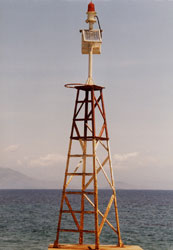
Murtos (Mavro Oros, Sivota Island)
latitude 39° 24' 18.9" N longitude 20° 12' 34.2" E |
This lighthouse was built by French contractors for the Ottoman Empire; the area was ceded to Greece in 1913 at the end of the Balkan Wars. Located on a very steep promontory at the western end of the island of Syvota, about 3 km west of the mainland town of the same name photo ARLHS # GRE-118 |
|
|
| GR 9 |
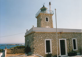
Laka (1825) (Paxio Island) |
ARLHS # GRE-089 |
| GR 10 |
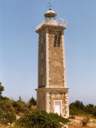
Laka (1919) (Paxio Island)
latitude 39° 14' 8.6" N longitude 20° 7' 41.4" E
The lighthouse is located near Lakka at the northwestern tip of the island, about 9 km northwest of Gaios, the principal town and ferry port. ARLHS # GRE-088
Photo courtesy Phil James [Flickr] |
|
| GR 11 |
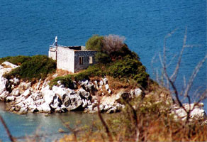
Panagia (Isle Panagia (Paxoi))
latitude 39° 12' 16.5" N longitude 20° 11' 41.7" E |
This lighthouse was built by Britain. Panagia is a small island off the north side of the entrance to the harbor of Gaios; the island is also the site of a historic monastery, the Moni Panagias. Transportation to the island is available from Gaios. Located at a high point at the northeastern end of the island. photo ARLHS # GRE-102 |
| GR 14 |
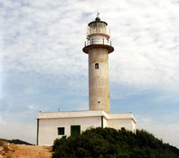
Antipaxos (Cape Oboros, Antipaxos Island)
latitude 39° 8' 26.4" N longitude 20° 14' 54.2" E
Antipaxos is a small island about 2.5 km southeast of Paxi. Boat transportation to the island can be arranged in Gaios. The lighthouse was staffed but it is now automated. Located at the southeastern tip of the island. ARLHS # GRE-100
Photo courtesy Konstantinos [Flickr] |
|
| GR 15 |
Akra Akra (Stenon Prevezis) |
ARLHS # GRE-157 |
| GR 16 |
Fort East Coast Levkas (Lefkada) |
ARLHS # GRE-068 |
| GR 16V |
Volios
latitude 38° 47' 40.5" N longitude 20° 43' 43.1" E
This light marks the southern entrance to the strait separating Lefkada from the mainland; it is located on a small island just off the mainland about 6 km south of the Lefkada bridge. (It is not on Lefkada, as both Savas and ARLHS imply.) (E 3842) ARLHS # GRE-130
Photo courtesy Alex Trabas [ListOfLights] |
|
| GR 18 |
Akra Eliar |
ARLHS # GRE-164 |
| GR 19 |
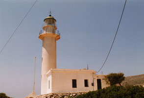
Dukato (Lefkas Island)
latitude 38° 33' 48.8" N longitude 20° 32' 34.1" E
The light station stands atop a spectacular cliff at the southern tip of Lefkáda, commanding a view of the islands of Ithiki and Kefalloniá. According to legend, the poet Sappho is threw herself to her death from this cliff around 570 BC. Located at the southwestern tip of Lefkáda, about 50 km south southwest of the town of Lefkada at the end of a long unpaved road; 4WD recommended. (E 3836) ARLHS # GRE-060
Photo courtesy Alex Trabas [ListOfLights] |
|
|
|
| GR 20 |
Akra Anemomilos |
ARLHS # GRE-159 |
| GR 21 |
Akra Ayiou Nikolaou |
ARLHS # GRE-162 |
| GR 22 |
Fiskardo (15xx)
latitude 38° 27' 37.7" N longitude 20° 34' 55.4" E
Located on a promontory on the east side of Kefalloniá's northern tip, marking the entrance to the channel between Kefalloniá and the neighboring, smaller island of Itháki (Ithaka).
Photo courtesy Tom Longfield [Flickr] |
|
| GR 23 |
| Fiskardo (1892) (Kefalonia Island)
latitude 38° 27' 39.9" N longitude 20° 34' 55.1" E
Located a short distance uphill from the Venetian lighthouse. (E 3876) ARLHS # GRE-065
Photo courtesy Alex Trabas [ListOfLights] |
| GR 24 |
Akra Piscactou |
ARLHS # GRE-176 |
| GR 25 |
Lefkas (Lefkáda, Santa Maura)
latitude 38° 50' 43.2" N longitude 20° 43' 11.5" E
The northern end of the island of Lefkáda is separated from the mainland only by a narrow channel, now crossed by a causeway and floating bridge. The citadel protects the northern entrance to this channel, just north of the bridge, on the north side of the town of Lefkáda. ARLHS # GRE-184
Photo courtesy patrizia ferri [Flickr] |
|
| GR 26 |
Akra Ayiou Ioannou |
ARLHS # GRE-161 |
| GR 27 |
Akra Dhik Halia
latitude 38° 16' 50.9" N longitude 20° 40' 33.2" E |
The present light tower is at least the third, possibly the fourth. Located on a promontory marking the entrance to the bay of Sami, on the east side of the island, about 5 km northeast of the town of Sami ARLHS # GRE-163 |
| GR 29 |
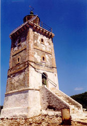
Gerogompos (Kefalonia Island)
latitude 38° 10' 48.5" N longitude 20° 20' 29.9" E
The original lighthouse was destroyed by retreating German troops late in World War II; it was replaced using the same plans as the original. Located on a promontory at the southwestern tip of Kefalloniá, about 12 km west of Lixouri. (E 3880) ARLHS # GRE-132
Photo courtesy Alex Trabas [ListOfLights] |
|
| GR 30 |
Vardiani (1824) (Vardianoí) |
This lighthouse was built to mark the entrance to the Gulf of Argostóliou, a protected bay on the southwest side of Kefalloniá that leads to the island's principal town, Argostóli. Heavily damaged by a 1953 earthquake, the lighthouse was replaced rather than repaired. |
| GR 31 |
Vardiani (new) (Kefalonia Island)
latitude 38° 8' 0.1" N longitude 20° 25' 35.7" E
Located on the southeast point of the island of Vardianoi, about 3 km southwest of the entrance to the Gulf of Argostóliou. (E 3882) ARLHS # GRE-186
Photo courtesy Alex Trabas [ListOfLights] |
|
| GR 32 |
Akra Kapri |
ARLHS # GRE-165 |
| GR 33 |
Ayii Theodori (Kefalonia Island)
latitude 38° 11' 29" N longitude 20° 28' 4.6" E
The present structure is a replica of the original lighthouse, which was heavily damaged by an earthquake in 1953. Located on the east side of the Gulf of Argostóliou at the northwestern tip of a cape protecting the harbor of Argostóli. ARLHS # GRE-048
Photo courtesy Rob Wallace [Flickr] |
|
| GR 34 |
Akra Katelios |
If anyone wants to book direct for either the original Lighthouse (above the taverna on the seafront), or the new Lighthouse, you can contact Kostas on +30 26710 81090 (landline) or on +30 6942 511574 (mobile) ARLHS # GRE-167 |
| GR 35 |
Skinari (Zante Island)
The area around the light station is well known for the 'blue caves' cut into the limestone cliffs by the sea and for several historic stone windmills. Located on Cape Skinari, the northern tip of Zákynthos, about 1.5 km north of Korithi. ARLHS # GRE-119
Photo courtesy Rob Wallace [Flickr] |
|
| GR 36 |
| Akra Krioneri
latitude 37° 48' 16.4" N longitude 20° 54' 16.3" E
This light marks the narrowest point of the passage between Zákynthos and the mainland. Located on a promontory on the southeastern side of the island. (E 3986) ARLHS # GRE-171
Photo courtesy Alex Trabas [ListOfLights] |
| GR 37 |
Keri (Zante Island)
latitude 37° 39' 17.2" N longitude 20° 48' 28.7" E
The area is famous for its spectacular cliffs overlooking the Ionian Sea. Located on Cape Keri, the southern tip of Zákynthos, near the town of Keri. (E 3990) ARLHS # GRE-081
Photo courtesy Alex Trabas [ListOfLights] |
|
| GR 38 |
| Strofades (Stamfani Island)
latitude 37° 14' 52.2" N longitude 21° 47.8" E
The Strofades are a small group of islands about 40 km south southeast of Cape Keri. The largest island, Stamfani, is the site of a 14th century Byzantine monastery, now occupied by a single monk as a caretaker. Located at the western tip of Stamfani. ARLHS # GRE-122
Photo courtesy Kostas Koutsis [panoramio] |
| GR 39 |
Akra Navarinou
latitude 36° 54' 23.8" N longitude 21° 40' 22.4" E |
The modern Pilos (or Navarino, locally called Neokastro) is the capital of the eparkhia ("eparchy") of Pylia in the nomos (department) of Messenia, Greece, on the southern headland of the Ormos (bay) Navarinou, a deepwater shipping channel on the southwest coast of the Peloponnese. The smaller island of Pilos to the south has a lighthouse and a monument to French sailors who fell at the Battle of Navarino (1827). ARLHS # GRE-175 |
|
|
 Albania