|
This page shows the documentation of the Lighthouses of Southern (Mediterranian) France. Some of the photos below are available on webshots, some of the are on Flickr (and are reproduced with permission) and you can always click on the light to go to it's specific (larger resolution) copy. Each lighthouse is linked to (in our editorial opinion) the best reference site for that light. I would like to include directions on how to get to these lights. If you know such data, could you eMail me and I'll post it here (with your choice of attribution.) mailme There has been significant usage of the Lighthouse Directory prepared by Russ Rowlett (UNC). My thanks to him for providing this basis for understanding. lhDirectory |
|
Pyrénées-Orientales
FR 402
[FR128] |
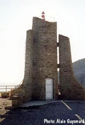
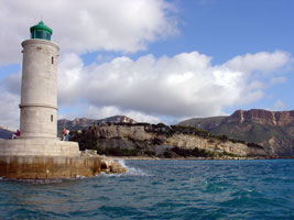
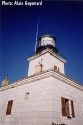
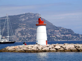
Cap Cerbère
latitude 42° 26' 22.1" N longitude 3° 10' 35.6" E
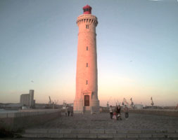
The lighthouse marks the southernmost promontory of mainland France, about 600 m north of the Spanish border. Located on the cape, about 1.5 km east of the Cerbère waterfront, accessible by the twisting N114 coastal highway. (E 0492) ARLHS # FRA-215
Photo courtesy Alain Guyomard [phares] |
|
FR 403
[FR129] |
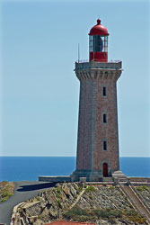
| Cap Béar
latitude 42° 30' 56" N longitude 3° 8' 11.9" E
Located on the cape about 2.5 km east of Port-Vendres, accessible by road. (E 0496) ARLHS # FRA-212
Photo courtesy Guy Banyuls [Flickr] |
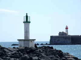
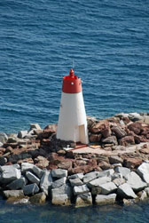
FR 404
[FR130] |
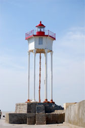
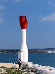
Port-Vendres Môle de l'Est (Pointe de la Presqu'île)
latitude 42° 31' 22.5" N longitude 3° 7' 3.2" E
Located at the end of the east breakwater at Port-Vendres, appears to be accessible by walking the breakwater. (E 0504) ARLHS # FRA-599
Photo courtesy Ben [Kabloes] |
|
FR 405
[FR131] |
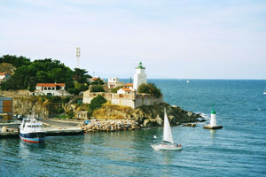
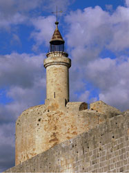
| Port-Vendres (Fort du Fanal)
latitude 42° 31' 16.5" N longitude 3° 6' 49.3" E
Located on a bluff on the west side of the harbor entrance at Port-Vendres. (E 0498) ARLHS # FRA-395
Photo courtesy carnifex [Flickr] |
FR 406
[FR132] |
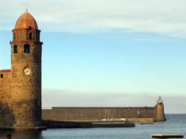
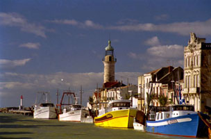
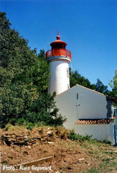
Collioure
latitude 42° 31' 39.5" N longitude 3° 5' 19.5" E
Located at the end of the jetty on the north side of the harbor entrance at Collioure, a small fishing port about 3 km northwest of Port-Vendres. (digitally brightened for this presentation) (E 0512) ARLHS # FRA-243
Photo courtesy xwa [Flickr] |
|
FR 407
[FR132R] |
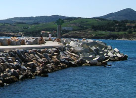
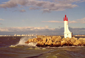
| Argeles Digue East
latitude 42° 32' 35.2" N longitude 3° 3' 18.1" E
Argeles sur Mer is a small touristic center situated between Collioure and Saint-Cyprien, in the Languedoc Roussillon, department of Pyrénées Orientales (66).
Located in the outer jetty protecting the marina. It looks like you could walk the jetty in good weather. (E 0512.5)
Photo courtesy Océane Legrand [Une balade en France] |
| FR 408 |
Argeles Digue West
latitude 42° 32' 35.3" N longitude 3° 3' 14.4" E
Argeles sur Mer is a small touristic center situated between Collioure and Saint-Cyprien, in the Languedoc Roussillon, department of Pyrénées Orientales (66).
Located in the inner jetty protecting the marina. It looks like you could walk the jetty in good weather. (E 0512.6) ARLHS # FRA-243
Photo courtesy Océane Legrand [Une balade en France] |
|
FR 409
[FR133] |
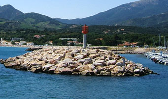
| Canet-Plage Jetée du Sud
latitude 42° 42' 9.6" N longitude 3° 2' 32.4" E
Located at the end of the breakwater at Canet-Plage, the beach resort town adjacent to Canet-en-Roussillon. It's a long walk. (E 0515) ARLHS # FRA-829
Photo courtesy Jean-Marie Monplot [phare] |
FR 410
[FR134] |
Canet-Plage
latitude 42° 42' 28" N longitude 3° 2' 15.7" E
Located on the dunes behind the beach at Canet-Plage, about 800 m north of the harbor. ARLHS # FRA-828
Photo courtesy Ivan Prados [panoramio] |
|
Aude
FR 411
[FR135] |
| Cap Leucate
latitude 42° 54' 41.3" N longitude 3° 3' 24.5" E
Located on a headland in Leucate-Plage. (E 0518) ARLHS # FRA-230
Photo courtesy Alain Guyomard [phare] |
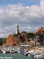
FR 414
[FR138] |
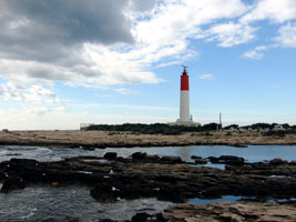
Narbonne-Plage (Bassin des Exals)
latitude 43° 10' 15.4" N longitude 3° 10' 49.5" E
Located atop a bluff at the small boat harbor of Bassin des Exals, about halfway between the beach towns of Narbonne-Plage and St.-Pierre-sur-Mer. (E 0527.2) ARLHS # FRA-185
Photo courtesy Thierry Veine [phare] |
|
Hérault
FR 415
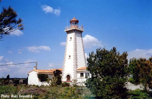
[FR140] |
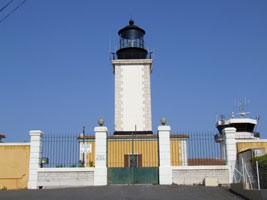
| Agde Jetée de l'Est
latitude 43° 16' 47.7" N longitude 3° 26' 37.9" E
This lighthouse replaced a cast iron tourelle installed in 1867. Located at the end of the east jetty at the mouth of the Rivière de l'Hérault in Le Grau d'Agde. (E 0535) ARLHS # FRA-068
Photo courtesy Hendrik Martin Porath [ListOfLights] |
FR 416
[FR139] |
Agde Jetée de l'Ouest
latitude 43° 16' 49.9" N longitude 3° 26' 33.9" E
Located at the end of the west jetty at the mouth of the Rivière de l'Hérault opposite Le Grau d'Agde. The jetty is accessible by a road on the west side of the river. (E 0534) ARLHS # FRA-140
Photo courtesy Ludovic Copéré [Flickr] |
|
FR 417
[FR142] |
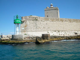
Fort Brescou (1836)
latitude 43° 15' 46.8" N longitude 3° 30' 6.2" E |
The Île de Brescue is a fortified island in the Mediterranean off Cap d'Agde, built for defense, the fort was later used for many years as a prison. Located about 1.5 km south of the point of Cap d'Agde. Accessible only by boat, guided tours of the fort are available. tours ARLHS # FRA-702 |
FR 418
[FR143] |
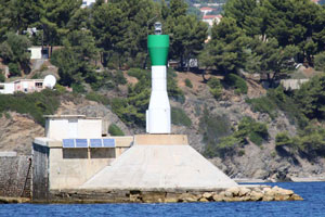
Fort Brescou (1901)
latitude 43° 15' 47" N longitude 3° 30' 7.3" E
Located at the southern (seaward) corner of the fort. (E 0538) ARLHS # FRA-015
Photo courtesy David Reverchon [Flickr] |
|
FR 419
[FR141] |
| Cap d'Agde (Mont St. Loup)
latitude 43° 17' 54.2" N longitude 3° 30' 10.8" E
Located on the summit of Mont Saint Loup, an extinct volcano rising behind the town of Cap d'Agde. ARLHS # FRA-083
Photo courtesy v. Guyonnet [phare] |
FR 421
[FR145] |
Marseillan
latitude 43° 19' 5" N longitude 3° 33' 35.8" E
Located on both sides of the entrance to the harbor of Marseillan from the Étang de Thau. (E 0542)
Photo courtesy Alain Guyomard [phare] |
|
FR 422
[FR144] |
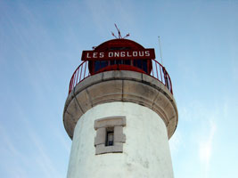
| Les Onglous (Canal du Midi)
latitude 43° 20' 24.1" N longitude 3° 32' 23.2" E
It marks the entrance from the sound into the Canal du Midi. Built in the late 1600s, the Canal du Midi provided (and still provides) a water connection between the Mediterranean and the Garonne, which flows into the Atlantic below Bordeaux. Located at the canal entrance, about 1.5 km south of Marseillan. (E 0568) ARLHS # FRA-376
Photo courtesy Jan Hugo Vandenplas [Flickr] |
FR 423
[FR146] |
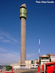
Sète (Mont St. Clair)
latitude 43° 23' 44.1" N longitude 3° 41' 23.7" E
Located on the slope of Mont Saint Clair, to the west of the harbor entrance and just below the sailors' cemetery. (E 0544) ARLHS # FRA-362
Photo courtesy Barry [Flickr] |
|
FR 424
[FR149] |
| Sète Épi Dellon
latitude 43° 23' 35.8" N longitude 3° 42' 10.4" E
The light at the end of the breakwater may also qualify as a lighthouse. Located at the center of the breakwater's southeastern extension. (E 0547.5) ARLHS # FRA-559
Photo courtesy Alex Trabas [ListOfLights] |
FR 425
[FR148] |
Sète Brise-Lame (Outer Breakwater)
latitude 43° 23' 45.6" N longitude 3° 42' 28.8" E
When it was built, this lighthouse marked the west end of the outer breakwater; by the 1890s, the breakwater had been extended southwestward, so the lighthouse now stands in the elbow where this newer section joins the original. Accessible only by boat (the outer breakwater does not connect to shore). (E 0547) ARLHS # FRA-836
Photo courtesy Alex Trabas [ListOfLights] |
|
FR 426
[FR147] |
| Sète Môle St.-Louis
latitude 43° 24' 3.6" N longitude 3° 43' 33" E
The Môle Saint Louis is the historic breakwater mole sheltering the port and the canal entrance; today there is also an outer breakwater to the southeast. (E 0546) ARLHS # FRA-486
Photo courtesy Rémi Vernier [Flickr] |
Gard
FR 426M
[FR155] |
Aigues-Mortes (Tour Constance)
latitude 43° 34' 6.5" N longitude 4° 11' 23.2" E
After the crusades, the canal silted up and the tower ceased to show a light. Located in Aigues-Mortes, a historic port town now 6 km northeast of Grau-du-Roi and the sea. ARLHS # FRA-512
Photo courtesy Paul [Flickr] |
|
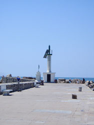
FR 427
[FR150] |
| Grau-du-Roi
latitude 43° 32' 11.5" N longitude 4° 8' 4.3" E
This lighthouse was replaced in 1869 by the Phare de l'Espiguette, but the old tower has been carefully preserved. Located on the west side of the canal entrance in Grau-du-Roi. ARLHS # FRA-307
Photo courtesy frantonton [Webshots] |
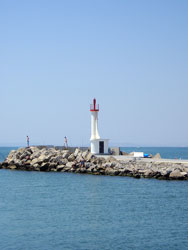
FR 428
[FR151] |
Grau-du-Roi Jetée de l'Ouest
latitude 43° 32' 5.1" N longitude 4° 7' 55.8" E
Located at the end of the west jetty at Grau-du-Roi. (E 0582.2) ARLHS # FRA-309
Photo courtesy frantonton [Webshots] |
|
FR 429
[FR152] |
| Grau-du-Roi Jetée de l'Est
latitude 43° 32' 6.9" N longitude 4° 7' 54.4" E
the East jetty. (E 0582) ARLHS # FRA-308
Photo courtesy Alex Trabas [ListOfLights] |
|
|
FR 430
[FR153] |
Port Camargue Jetée de l'Est
latitude 43° 31' 15.4" N longitude 4° 7' 21.5" E
Located at the end of the east jetty at Port Camargue, about 2.5 km south of Grau-du-Roi. (E 0583.4) ARLHS # FRA-669
Photo courtesy Alex Trabas [ListOfLights] |
|
FR 431
[FR154] |
| Port Camargue Jetée de l'Ouest
latitude 43° 31' 16.7" N longitude 4° 7' 17.7" E
The west jetty (E 0584.2) ARLHS # FRA-666
Photo courtesy Alex Trabas [ListOfLights] |
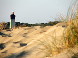
FR 432
[FR156] |
L'Espiguette
latitude 43° 29' 15.6" N longitude 4° 8' 30.6" E
The Pointe de l'Espiguette is a broad, sandy barrier, the southwestern extension of the Camargue. Sediment from the Rhône is accumulating here, the lighthouse was built 150 m from the sea but now it is a full kilometer from the surf. Located at the end of the Route de l'Espiguette about 6 km southeast of Grau-du-Roi. (E 0586) ARLHS # FRA-276
Photo courtesy lacrymale [Flickr] |
|
Camargue
FR 433
[FR157] |
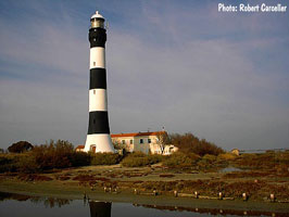
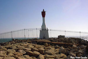
| La Gacholle
latitude 43° 27' 17.4" N longitude 4° 34' 13" E
Located about 11 km east of Saintes-Maries-de-la-Mer, the one town on the Camargue coast. Accessible by a walk of about 2 km from a parking area, which is accessible by unpaved park roads from Salin de Giraud on the east side of the Camargue. (E 0592) ARLHS # FRA-297
Photo courtesy Robert Carceller [phares] |
FR 434
[FR158] |
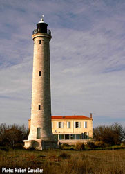
Beauduc (Pointe du Sablon)
latitude 43° 21' 52.5" N longitude 4° 35' 4.2" E
This lighthouse stands on a sweeping curve of the narrow barrier island at the southern end of the Camargue; the area is quite remote and not easy to reach. Located about 16 km southeast of Saintes-Maries-de-la-Mer. (E 0594) ARLHS # FRA-188
Photo courtesy Robert Carceller [phares] |
|
FR 435
[FR159] |
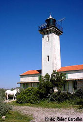
| Faraman
latitude 43° 21' 16.8" N longitude 4° 41' 13.7" E
Accessible by a unpaved park road, the Route du Sémaphore, which crosses the wetlands on a series of dikes and causeways. (E 0600) ARLHS # FRA-098
Photo courtesy Robert Carceller [phares] |
FR 436
[FR161] |
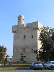
Port Saint-Louis-du-Rhône
latitude 43° 23' 4.6" N longitude 4° 48' 17.9" E
The Tour Saint-Louis, built in 1737, is the symbol of the town of St.-Louis-du-Rhône. It houses the local tourist office and a museum. Located in the center of St.-Louis-du-Rhône. (E 0603) ARLHS # FRA-485
Photo courtesy Alex Trabas [ListOfLights] |
|
FR 437
[FR160] |
| Canal de Saint-Louis
latitude 43° 23' 24.2" N longitude 4° 52' 17.2" E
The Canal de Saint-Louis is a short channel connecting the Grande Rhône, the principal branch of the river, to the Golfe de Fos to the east. Located on the waterfront of St.-Louis-du-Rhône, the town closest to the mouth of the Grande Rhône, on the east side of the Camargue. (E 0602) ARLHS # FRA-549
Photo courtesy Robert Carceller [phares] |
FR 438
[FR162] |
Saint-Gervais (Fos)
latitude 43° 25' 34.6" N longitude 4° 56' 20.9" E
The lighthouse guides ships into the Golfe de Fos, a sheltered bay on the east side of the Camargue about 30 km west of Marseille. Located adjacent to the yacht harbor of Fos-sur-Mer. (E 0606.8) ARLHS # FRA-478
Photo courtesy Robert Carceller [phares] |
|
FR 439
[FR163] |
| Port de Bouc Jetée Nord
latitude 43° 23' 46.9" N longitude 4° 59' 5" E
Located at the end of the breakwater jetty on the north side of the entrance to Port de Bouc. (E 0608)
Photo courtesy Alex Trabas [ListOfLights] |
FR 440
[FR164] |
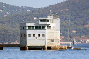
Port-de-Bouc (Fort de Bouc)
latitude 43° 23' 38.1" N longitude 4° 59' 8.4" E
Located on the south side of the entrance to Port-de-Bouc and the Chenal de Caronte, the channel leading to the large Étang (sound) de Berre. In the background is the fort itself, in the foreground is the South Side Entrance light. ARLHS # FRA-288
Photo courtesy Philippe Fabre [Flickr] |
|
Marseille
FR 441
[FR165] |
| Cap Couronne
latitude 43° 19' 32" N longitude 5° 3' 11.6" E
This lighthouses marks the eastern entrance to the Golfe de Fos and shows a red light for ships bound westward to Marseille. Located at the end of the Chemin du Phare in La Couronne, about 30 km west of Marseille. (E 0622) ARLHS # FRA-090
Photo courtesy Doris Peterson [Flickr] |
FR 442
[FR166] |
Sausset-les-Pins
latitude 43° 19' 43" N longitude 5° 6' 29.8" E
Located on the west jetty at Sausset-les-Pins, a small boat harbor about 25 km west of Marseille. (E 0624) ARLHS # FRA-468
Photo courtesy Thomas Lamotte [Flickr] |
|
FR 443
[FR167] |
| Pain de Sucre (Carry-le-Rouet)
latitude 43° 19' 41.1" N longitude 5° 9' 9.4" E
Located at the end of a jetty in Carry-le-Rouet, about 4 km east of Sausset-les-Pins. (E 0624.8) ARLHS # FRA-839
Photo courtesy Manda [Flickr] |
FR 444
[FR168] |
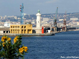
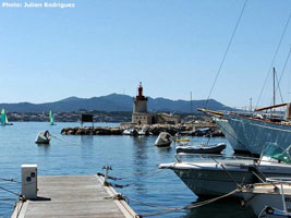
Sainte-Marie (La Joliette)
latitude 43° 17' 57.5" N longitude 5° 21' 29.4" E
This lighthouse, a familiar landmark of the waterfront, stands at the south entrance to the bassins on the Dique Sainte-Marie; the entrance is called the Passe de la Joliette and it leads to the southernmost bassin, the Bassin de la Grande Joliette. ARLHS # FRA-842
Photo courtesy Julien Rodriguez [phare] |
|
FR 445
[FR169] |
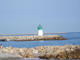
| Dique Sainte-Marie (Feu rouge de la traverse de la Major)
latitude 43° 17' 56.9" N longitude 5° 21' 28.7" E
The red light (and Sainte-Marie (above)) is accessible via the Quay Jean Charcot (and it looks like a long walk). (E 0657) ARLHS # FRA-842
Photo courtesy Julien Rodriguez [phare] |
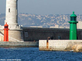
FR 446
[FR170] |
Dique du Fort Saint-Jean (Feu vert de la traverse de la Major)
latitude 43° 17' 53" N longitude 5° 21' 31.3" E |
The green light (above) is located at the end of the breakwater extending from Fort Saint-Jean. (E 0662) ARLHS # FRA-554 |
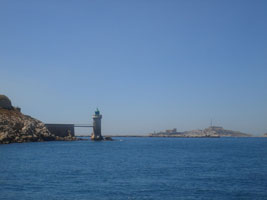
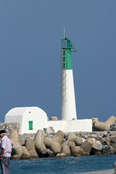
FR 447
[FR171] |
La Désirade (Le Pharo)
latitude 43° 17' 49.6" N longitude 5° 21' 10.5" E
Located on the Pointe de la Désirade, also called the Pointe du Pharo, on the south side of the harbor entrance of Marseille. There may be a view from the end of the Rue des Catalans but most photos seem to be taken from the water. (E 0660) ARLHS # FRA-260
Photo courtesy Julien Rodriguez [phares] |
|
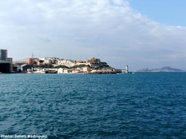
FR 448
[FR173] |
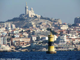
| Sourdaras
latitude 43° 17' 3" N longitude 5° 20' 20.7" E
This historic beacon marks a shoal, the Banc de Sourdaras, roughly halfway between the Château d'If and the mainland at Pointe d'Endoume. Located about 600 m west of the Pointe d'Endoume. Accessible only by boat; there should be fairly good views from many locations onshore. (E 0674) ARLHS # FRA-837
Photo courtesy Julien Rodriguez [phares] |
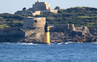
FR 449
[FR174] |
Canoubier |
This beacon, the Tourelle de Canoubier, is the oldest French beacon to be built at sea on an underwater foundation. It is located southeast of the Feu de Sourdaras, off the Pointe d'Endoume |
FR 450
[FR172] |
Château d'If
latitude 43° 16' 48.5" N longitude 5° 19' 38.9" E
The château was made famous through the Alexandre Dumas novel, The Count of Monte Cristo. Tours of the island are available. Located at the eastern tip of the island, marking the entry to Marseille from the south, about 2.5 km southwest of the Pointe de la Désirade. ARLHS # FRA-236
Photo courtesy Gabriele de Benedittis [Flickr] |
|
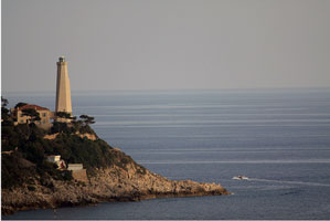
FR 451
[FR175] |
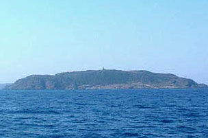
| Le Planier
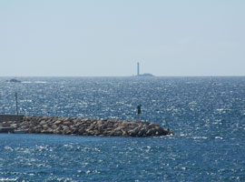
The tiny Île du Planier, 13 km southwest of Marseille, is part of an extensive system of reefs that endangers all ships bound for Marseille. (E 0680) ARLHS # FRA-051
Photo courtesy Pierre Numérique [Flickr] |
FR 452
[FR176] |
Cassis
latitude 43° 12' 47.2" N longitude 5° 32' 2.1" E
Located at the end of the mole sheltering the harbor of Cassis, about 20 km east of Marseille. (E 0686) ARLHS # FRA-840
Photo courtesy Alex GVA [Flickr] |
|
FR 453
[FR177] |
Cassidaigne |
This beacon marks the Banc de la Cassidaigne, a shoal 8 km south of Cassis. Accessible only by boat. (E 0690) ARLHS # FRA-179 |
FR 454
[FR178] |
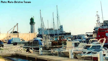
La Ciotat (Môle Bérouard)
latitude 43° 10' 14" N longitude 5° 34' 54.3" E
Located on the mole on the north side of the old harbor at La Ciotat, about 10 km southeast of Cassis. (E 0694) ARLHS # FRA-110
Photo courtesy Marie-Christine Toscano [phares] |
|
Toulon (French Riviera)
FR 455
[FR201] |
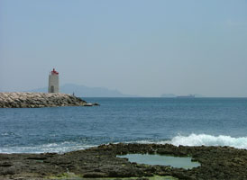
| La Fourmigue
latitude 43° 7' 36.7" N longitude 5° 45' 11.6" E
Located on a rock in the center of the entrance to Golfe Juan about 2.5 km south of the harbor. Accessible only by boat, there are distant views from shore everywhere in Golfe Juan. (E 0806)
Photo courtesy Fabien [Flickr] |
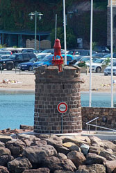
FR 456
[FR179] |
Sanary-sur-Mer
latitude 43° 6' 52.8" N longitude 5° 48' 2.4" E
Located at the end of the breakwater on the west side of the harbor at Sanary-sur-Mer. (E 0704) ARLHS # FRA-467
Photo courtesy Julien Rodriguez [phares] |
|
|
|
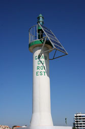
FR 457
[FR180] |
| Grand-Rouveau
latitude 43° 4' 49.1" N longitude 5° 46' 3.5" E
The Île du Grand Rouveau is the westernmost of the Îles des Embriez, a group of five islands with associated reefs and shoals. (E 0710) ARLHS # FRA-019
Photo courtesy Christophe Boxus [ListOfLights] |
FR 458
[FR181] |
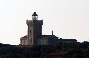
Cap Cépet (1851)
latitude 43° 4' 4.9" N longitude 5° 56' 41.5" E |
In 1992, the Navy relocated the light, but it also restored the lighthouse as a historical monument. Located on the point of the cape, about 2 km east of St.-Mandrier-sur-Mer. ARLHS # FRA-078 |
FR 459
[FR182] |
Cap Cépet (1992)
latitude 43° 4' 3.2" N longitude 5° 56' 40.6" E
Located roughly 100 m from the historic lighthouse. (Apologies for the photo quality, it's out of the middle of distant view.) (E 0714) ARLHS # FRA-830
Photo courtesy Alex Trabas [ListOfLights] |
|
FR 460
[FR183] |
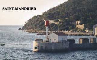
| Saint-Mandrier Jetée
latitude 43° 5' 11.5" N longitude 5° 56' 3.4" E
Located at the end of the breakwater jetty of St.-Mandrier-sur-Mer. (E 0716) ARLHS # FRA-487
Photo courtesy Jean-Chrisophe Fichou [phares] |
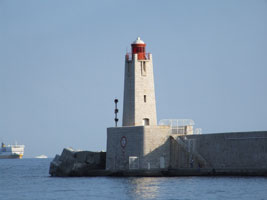
FR 461
[FR184] |
Toulon Grand Jetée
latitude 43° 5' 20.2" N longitude 5° 55' 31.4" E
The inner harbor of Toulon, called the Petite Rade (little roads), is protected by a 1400 m long breakwater completed in 1882. This light marks the main ship channel, which rounds the south end of the breakwater. (E 0717) ARLHS # FRA-562
Photo courtesy Alexander Trabas [ListOfLights] |
|
FR 462
[FR185] |
| Toulon Petite Passe
latitude 43° 6' 4" N longitude 5° 55' 35.9" E
Located on the jetty beyond the end of the Rue du Vice-Amiral d'Escadre Pierre in southeastern Toulon. (E 0720) ARLHS # FRA-393
Photo courtesy Alexander Trabas [ListOfLights] |
FR 463
[FR183A] |
Le Mourillon
latitude 43° 6' 21.5" N longitude 5° 56' 13.8" E
Located at the end of the breakwater mole at the Port du Mourillon [in Toulon], a small boat harbor at the foot of the Rue Pierre Suffren, about 1 km northeast of the Petite Passe. (E 0742)
Photo courtesy Chrisophe Jeannette [Flickr] |
|
Îles d'Hyères
FR 464
[FR186] |
| Grand-Ribeau
latitude 43° 59.2" N longitude 6° 8' 39.1" E
Located on the south point of the island, about 2.5 km southeast of Giens. There should be a distant view from the ferry. (E 0748) ARLHS # FRA-304
Photo courtesy Alex Trabas [ListOfLights] |
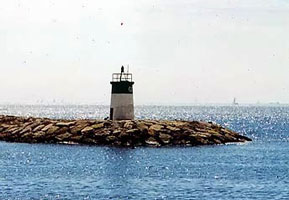
FR 468
[FR188] |
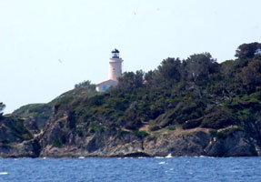
| Cap d'Arme (Porquerolles)
latitude 42° 58' 59.7" N longitude 6° 12' 22.9" E
The lighthouse is a popular attraction because of its spectacular view of the Mediterranean and the Îles d'Hyères; it is accessible by a hike of about 2.5 km one way from the village of Porquerolles, which can be reached by ferry from Giens.Located at the southernmost point of the Île de Porquerolles. ARLHS # FRA-128
Photo courtesy Alain Guyomard [phares] |
FR 469
[FR189] |
Le Titan
latitude 43° 2' 47.3" N longitude 6° 30' 36.9" E
This historic lighthouse marks the eastern end of the Îles d'Hyères, making it a very important light for westbound shipping. Built at the eastern tip of the Île du Levant, it is located in a restricted military zone not accessible to the public. ARLHS # FRA-504
Photo courtesy Alexandre Moreaux [phares] |
|
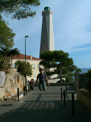
St. Tropez
FR 470
[FR190] |
| Cap Bénat
latitude 43° 5' 18.9" N longitude 6° 21' 46.5" E
Dedicated lighthouse fans can reach the light by a hike of about two hours each way on the spectacular coastal trail from La Favière. The lighthouse is actually located on Cap Blanc, the more southwesterly of the two forks of Cap Bénat. ARLHS # FRA-076
Photo courtesy Alain Guyomard [phares] |
FR 471
[FR191] |
Cap Camarat
latitude 43° 12' 3.7" N longitude 6° 40' 27.1" E
Located at the end of the Route de Camarat about 7 km by road southeast of Ramatuelle. (E 0772) ARLHS # FRA-208
Photo courtesy Arno+Evelin Siering [ListOfLights] |
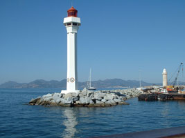
|
FR 472
[FR192] |
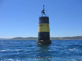
| La Moutte Bouée # 1 (Cap de St.-Tropez)
latitude 43° 16' 24.9" N longitude 6° 42' 36.9" E
Located about 1.5 km off the point of the Cap de St.-Tropez. There is a distant view from the end of the Chemin de la Moutte about 6 km east of St.-Tropez. ARLHS # FRA-366
Photo courtesy funkyman [Flickr] |
FR 473
[FR192R] |
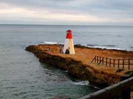
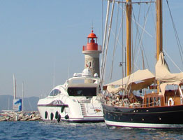
Saint-Tropez (Jetée Nord) (Phare Rouge)
latitude 43° 16' 21.4" N longitude 6° 37' 56.4" E
While a light was built here in 1869, the German troops destroyed it in 1944. In 2001, the city extended the jetty and built this reconstruction of the original. (E 0778) ARLHS # FRA-082
Photo courtesy mhobl [Flickr] |
|
FR 474
[FR193] |
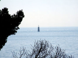
| Sèche à l'Huile
latitude 43° 18' 36.7" N longitude 6° 41' 4.3" E
This light marks the north side of the entrance to the Golfe de Saint-Tropez. Located at sea about 1 km off the Pointe des Sardinaux east of Sainte-Maxime. (E 0790) ARLHS # FRA-835
Photo courtesy Heike + Friedrich Klatt [ListOfLights] |
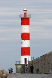
FR 475
[FR194] |
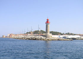
Saint-Raphaël
latitude 43° 25' 9.5" N longitude 6° 45' 2.5" E
Located at the end of the south jetty at Saint-Raphaël. ARLHS # FRA-501
Photo courtesy Brian Jacobson [Flickr] |
|
FR 476
[FR195] |
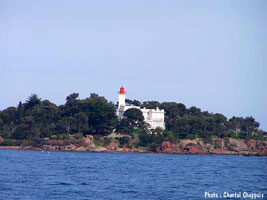
| Agay (La Baumette)
latitude 43° 25' 33.7" N longitude 6° 52' 13.9" E
Located on the Pointe des Baumettes, on the east side of the entrance to the beautiful Rade d'Agay, about 10 km east of Saint-Raphaël. (E 0795) ARLHS # FRA-190
Photo courtesy Chantal Chappuis [phares] |
Cannes
FR 477
[FR196] |
La Galère
latitude 43° 29' 57.6" N longitude 6° 57' 20.5" E
Located on the end of the breakwater at La Galère (E 0797) ARLHS # FRA-598
Photo courtesy Heike + Friedrich Klatt [ListOfLights] |
|
FR 478
[FR197] |
| Théoule-sur-Mer
latitude 43° 30' 51.7" N longitude 6° 56' 20.7" E
Located on the end of the breakwater at Théoule-sur-Mer (E 0798) ARLHS # FRA-626
Photo courtesy Heike + Friedrich Klatt [ListofLights] |
FR 479
[FR198] |
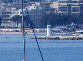
Cannes
latitude 43° 32' 42" N longitude 7° 57.6" E
This photo shows the new light (below) in the foreground, the old light in the background. ARLHS # FRA-271
Photo courtesy Happy A [Flickr] |
|
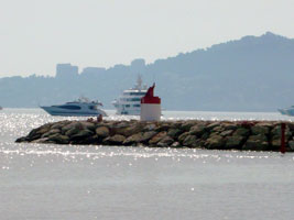
FR 480
[FR199] |
| Cannes Môle de l'Ouest
latitude 43° 32' 42.3" N longitude 7° 1' 2.8" E
Located at the end of the breakwater at the old harbor of Cannes. This breakwater is not walkable but the lighthouse can be seen from nearby. (E 0800) ARLHS # FRA-211
Photo courtesy xav [Flickr] |
FR 481
[FR200] |
Porto Canto
latitude 43° 32' 29" N longitude 7° 1' 46" E
Located at the end of the breakwater at Port Canto, a newer harbor on the east side of Cannes. (E 0803) ARLHS # FRA-660
Photo courtesy Heike + Friedrich Klatt [ListOfLights] |
|
Golf Juan and Antibes
FR 482
[FR202] |
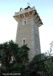
| Vallauris
Located off the Boulevard des Horrizons, high on the hillside in Vallauris, overlooking the Golfe Juan about 3 km east northeast of the Cannes waterfront. (E 0808) ARLHS # FRA-530
Photo courtesy Adrien Mortini [Structurae
All rights reserved.] |
FR 483
[FR201A] |
Golfe Juan Jetée du Large
latitude 43° 33' 47.4" N longitude 7° 4' 37.5" E
Located at the end of the breakwater mole of Golfe Juan. Accessible by walking the mole. ARLHS # FRA-561
Photo courtesy Marie-Christine Toscano [phares] |
|
FR 484
[FR203] |
| Porto Gallice (Juan les Pins)
latitude 43° 33' 45.2" N longitude 7° 6' 45.4" E
Located at the end of the breakwater at Port Gallice, a small harbor on the east side of Golfe Juan (and the west side of the Cap Antibes peninsula). (E 0811) ARLHS # FRA-834
Photo courtesy Arno+Evelin Siering [ListOfLights] |
FR 485
[FR203E] |
Porto Gallice East Head (Le Crouton)
latitude 43° 33' 44.9" N longitude 7° 6' 52.2" E
Located at the end of the East breakwater at Port Gallice. (E 0812.2) ARLHS # FRA-834
Photo courtesy Arno+Evelin Siering [ListOfLights] |
|
FR 486
[FR204] |
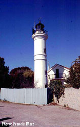
| L'Ilette
This lighthouse is located at the southwestern point of the Cap d'Antibes peninsula, marking the east side of the entrance to Golfe Juan (in a restricted residential area). (E 0814) ARLHS # FRA-120
Photo courtesy Francis Marc [phares] |
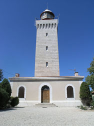
FR 487
[FR205] |
La Garoupe (Antibes)
latitude 43° 33' 50.3" N longitude 7° 7' 59.6" E
The lighthouse is surrounded by the Bois de la Garoupe, a 22 acre forest preserve managed by the city of Antibes. Located on the Route du Phare in Antibes, overlooking the Baie des Anges. (E 0818) ARLHS # FRA-111
Photo courtesy Paul Boxley [Flickr] |
|
FR 488
[FR206] |
| Antibes Dique du Large (St-Laurent-du-Var)
latitude 43° 35' 26.1" N longitude 7° 7' 55.7" E
Located at the end of the breakwater at Antibes. (E 0821)
Photo courtesy Arno Siering [ListOfLights] |
FR 489
[FR207] |
Antibes Môle des Cinq Cents Francs
latitude 43° 35' 7.5" N longitude 7° 7' 38" E |
Located on the east side of the entrance to the old inner harbor of Antibes, off the Quai Henri Rambaud. |
FR 490
[FR208] |
Antibes Môle du Fort Carré
latitude 43° 35' 24.4" N longitude 7° 7' 47.4" E |
This light is located at the end of a breakwater mole on the west side of harbor, below the the 16th century Fort Carré. fort |
Nice and Cap Ferrat
FR 491
[FR209] |
Nice (1880)
latitude 43° 41' 33.4" N longitude 7° 17' 6.8" E |
Located at an elbow of the Nice breakwater. ARLHS # FRA-833 |
FR 492
[FR210] |
Nice (1950)
latitude 43° 41' 26.1" N longitude 7° 17' 17.8" E
Located at the end of the Nice breakwater (E 0822) ARLHS # FRA-370
Photo courtesy Arno Siering [ListOfLights] |
|
FR 493
[FR211] |
| Villefranche-sur-Mer
latitude 43° 41' 57.7" N longitude 7° 18' 37.9" E
Located at the end of the main breakwater of Villefranche-sur-Mer. (E 0830) ARLHS # FRA-534
Photo courtesy Richard M Marshall [Flickr] |
FR 494
[FR212] |
Cap Ferrat
latitude 43° 40' 29.2" N longitude 7° 19' 37.6" E
Cap Ferrat is a very prominent cape projecting into the Mediterranean between Nice and Monaco. Located above the point of the cape, on the Avenue du Phare in Villefranche-sur-Mer. (Different from FR 374 which you will notice is spelled Ferret) FR 374 (E 0828) |
|
FR 495
[FR213] |
| Saint-Jean-Cap-Ferrat
latitude 43° 41' 30.5" N longitude 7° 20' 8.2" E
Located at the end of the breakwater of Saint-Jean-Cap-Ferrat, on the peninsula of the cape about 2.5 km north of the Phare du Cap Ferrat. (E 0833) ARLHS # FRA-838
Photo courtesy Heike + Friedrich Klatt [ListOfLights] |
FR 496
[FR214] |
Menton
latitude 43° 46' 36.5" N longitude 7° 30' 44.5" E
Located on the end of the breakwater mole (the Quai Napoléon III) on the south side of the harbor of Menton, about 2 km west of the Italian border. (E 0848) ARLHS # FRA-357
Photo courtesy Doug Boit [Flickr] |
|
FR 497
[FR215] |
| Menton-Garavan
latitude 43° 46' 60" N longitude 7° 31' 19.4" E
Located at the end of the Garavan breakwater. (E 0849) ARLHS # FRA-356
Photo courtesy Chris Continanza [Flickr] |
Lakes
FR 498
[FR216] |
Aix-les-Bains
latitude 45° 42' 12" N longitude 5° 53' 2.8" E |
The Lac du Bourget, France's largest lake, is located in the Alps about halfway between Grenoble and Genève, Switzerland. The lake is 18 km long and has an altitude of 231.5 m. The resort town of Aix-les-Bains is on the east side of the lake. ARLHS # FRA-827 |
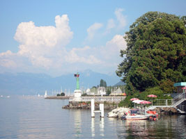
FR 499
[FR217] |
Amphion-les-Bains
latitude 46° 23' 42.1" N longitude 6° 32' 35.8" E |
Amphion-les-Bains is on the central south shore of Lac Leman (Lake Geneva), opposite Morges, Switzerland. Located at the end of the breakwater mole at Amphion-les-Bains. |
FR 500
[FR218] |
Évian-les-Bains
latitude 46° 24' 8.2" N longitude 6° 36' 19.8" E
Located at the end of a pier at Évian-les-Bains, a popular resort town about 4 km east of Amphion-les-Bains.
Photo courtesy "fleeting moment" [Flickr] |
|
|
|
 Eastern Spain
