|
This page shows the documentation of the Lighthouses of Corsica. Some of the photos below are available on webshots[] some of the are on Flickr (and are reproduced with permission) and you can always click on the light to go to it's specific (larger resolution) copy. Each lighthouse is linked to (in our editorial opinion) the best reference site for that light. I would like to include directions on how to get to these lights. If you know such data[] could you eMail me and I'll post it here (with your choice of attribution.) mailme There has been significant usage of the Lighthouse Directory prepared by Russ Rowlett (UNC). My thanks to him for providing this basis for understanding. lhDirectory |
|
East Coast
| FR 219 |
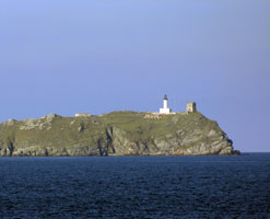
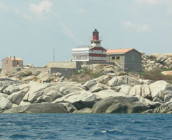
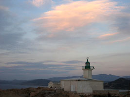
La Giraglia (Cap Corse)
latitude 43° 1' 35.9" N longitude 9° 24' 19.4" E
Located on the Île de la Giraglia, a small island about 2 km off the point of Cap Corse. Accessible only by boat, but there are good views from the vicinity of Barcaggio.
Photo courtesy ben7va [Flickr] |
|
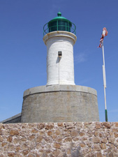
| FR 220 |
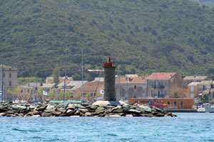
| Macinaggio
latitude 42° 57' 41.2" N longitude 9° 27' 16.9" E
This modest light replaced a cast iron tourelle. Located at the end of the breakwater at Macinaggio, the northernmost port of Corsica's east coast.
Photo courtesy Alberta [Flickr] |
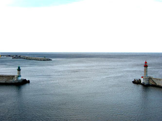
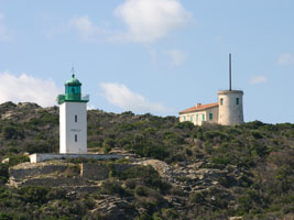
| FR 222 |
Bastia Môle Génois
latitude 42° 41' 41.2" N longitude 9° 27' 10.9" E
Located at the end of the north mole enclosing the old harbor of Bastia.
On the left is this light, on the right is the light below.
Photo courtesy Matthias Hoss [Flickr] |
|
| FR 223 |
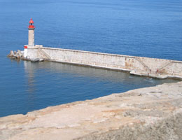
| Bastia Jetée du Dragon
latitude 42° 41' 39.1" N longitude 9° 27' 14.5" E
Located at the end of the south mole enclosing the old harbor of Bastia.
Photo courtesy Roby Ferrari [Flickr] |
| FR 224 |
Alistro
latitude 42° 15' 37.5" N longitude 9° 32' 25.6" E
This lighthouse is near the easternmost point of the island, but it does not mark any particular cape or hazard; its purpose is to fill in an otherwise dark section of the coastline. Located on the heights about 2 km from the coast near Alistro.
Photo courtesy Iolo [Flickr] |
|
| FR 225 |
| Punta San Ciprianu (Giovan Lungo, Pointe Saint-Cyprien)
latitude 41° 37' 3.7" N longitude 9° 21' 19.1" E
This lighthouse marks the north side of the entrance to the Golfe de Porto-Vecchio, the largest and best harbor on the east coast of Corsica. Located on the Punta San Ciprianu in Cala Rossa.
Photo courtesy ben7va [Flickr] |
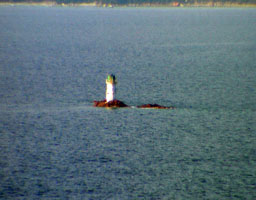
| FR 226 |
Pecorella
Located on a rock (Rocher Pecorella) in the center of the entrance to the Golfe de Porto-Vecchio, warning ships to pass to the south; the rock is about 1.5 km east of Punta San Ciprianu and the same distance north of Punta Chiappa. Accessible only by boat.
Photo courtesy ben7va [Flickr] |
|
| FR 227 |
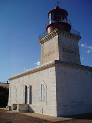
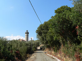
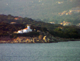
| La Chiappa (Porto Vecchio)
latitude 41° 35' 42.5" N longitude 9° 21' 55.7" E
Located on Punta Chiappa, the south side of the entrance to the Golfe de Porto-Vecchio, at the end of Route du Phare about 5 km northeast of Piccuvaghjia.
Photo courtesy ben7va [Flickr] |
Strait of Bonifacio
| FR 228 |
Perduto
latitude 41° 22' 5.5" N longitude 9° 18' 24.1" E |
The light was installed as part of France's responsibility under an agreement with Italy to improve the safety of navigation in the Strait of Bonifacio. Located on an isolated rock in the approach to the Strait from the northeast, about 7 km east of the southern tip of Corsica. Accessible only by boat. |
|
|
| FR 229 |
Les Lavezzi (Îles Lavessi)
latitude 41° 20' 4.4" N longitude 9° 15' 32.4" E
The Îles Lavezzi, located in the middle of the eastern entrance to the Strait of Bonifacio, have been the scene of countless shipwrecks, including the loss of the French frigate Sémillante and all 750 men aboard in February 1855. The islands are now a protected nature reserve; ecotours are available from Bonifacio. Located on the southern point of the largest island of the group. Accessible only by boat.
Photo courtesy Daniel Witting [Flickr] |
|
| FR 230 |
| Écueil Lavezzi (Tourelle des Lavezzi)
The word écueil means a reef, and this one is particularly hazardous. Located on an isolated rock in the very center of the Strait of Bonifacio about 1.5 km south of the Phare des Lavezzi. Accessible only by boat.
Photo courtesy nancesq [webshots] |
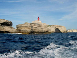
| FR 231 |
Pertusato
latitude 41° 21' 59.9" N longitude 9° 13' 12.2" E
One of the great lighthouses of the Mediterranean, this historic light marks the southernmost tip of Corsica. For ships eastbound through the Strait of Bonifacio, it is the rear light of a range, Cap Feno being the front light. Located on Mont Pertusato at the point of the cape, about 5 km southeast of Bonifacio.
Photo courtesy Agata Lucka [Flickr] |
|
| FR 232 |
| La Madonetta
latitude 41° 23' 13.5" N longitude 9° 8' 40.2" E
This lighthouse has a remarkable site atop a triangular block of sandstone attached to the mainland by a narrow peninsula. Located on the west side of the narrow entrance to the harbor of Bonifacio. There does not appear to be road access to this location.
Photo courtesy pfjc2 [webshots] |
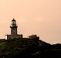
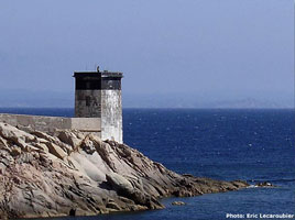
| FR 233 |
Cap Feno
latitude 41° 23' 31.8" N longitude 9° 5' 46.5" E
Located on the point of the cape, about 6 km west of Bonifacio, marking the north side of the western entrance to the Strait of Bonifacio. There does not appear to be road access to this location.
Photo courtesy Eric Lecaroubier [phares] |
|
Southwest Coast
| FR 234 |
| Les Moines
This light was built when it became clear that the Phare de Sénétosa did not provide enough protection for ships off the southwest coast of Corsica. Located on the rocky reef called the Éceuil des Moines (Monks' Reef), about 6 km off the rugged coastline. Accessible only by boat.
Photo courtesy Claudia&Mike Hovarka [LFseiten] |
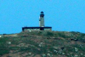
| FR 235 |
Sénétosa
latitude 41° 33' 30.7" N longitude 8° 47' 38.9" E
Only a few twin lighthouses were built in France, and it is not clear whether the second tower here was ever lit. Located on the rather rugged coastal road roughly 15 km southwest of Grossa.
Photo courtesy marinas.com [Marinas.com] |
|
| FR 236 |
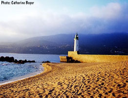
| Propriano
latitude 41° 40' 42.4" N longitude 8° 53' 58.4" E
Propriano is a small port on the Golfe de Valinco in southwestern Corsica. Located at the end of the Jetée du Scoglio-Longo, which also serves as a breakwater mole for Propriano.
Photo courtesy Catharine Boyer [Phares] |
|
|
| FR 237 |
Cap Muro
latitude 41° 44' 29.9" N longitude 8° 39' 44.9" E |
Located on the point of the cape, marking the southern entrance to the Golfe d'Ajaccio and the northern entrance to the Golfe de Valinco, about 7 km west of Acqua d'Oria. There does not appear to be any road access to this site. photo |
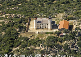
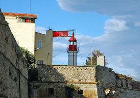
| FR 238 |
Ajaccio Citadelle
The lighthouse was built on the 16th century Citadelle d'Ajaccio, which stands on a peninsula projecting into the Golfe d'Ajaccio. The city's traditional harbor is sheltered behind the peninsula and the citadel.
Photo courtesy rmen [Flickr] |
|
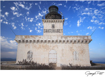
| FR 240 |
Îles Sanguinaires
latitude 41° 52' 43.5" N longitude 8° 35' 39.2" E
This is the landfall light for Ajaccio; it is built atop a steeply conical island in the northern entrance to the Golfe d'Ajaccio about 16 km west of the city. Ships arriving from France often pass through a narrow channel between the island and the mainland. Accessible only by boat.
Photo courtesy George Petit [TrekEarth] |
|
Northwest Coast
| FR 241 |
| La Revellata
latitude 42° 34' 59" N longitude 8° 43' 28.1" E
This is the landfall light for Calvi, a port on Corsica's northwest coast. Located at the tip of the Pointe de la Revellata, about 8 km northwest of Calvi via twisting mountain roads.
Photo courtesy Marlene Lokin [Flickr] |
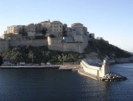
| FR 242 |
Calvi Jetée
latitude 42° 33' 59.4" N longitude 8° 45' 44.2" E
Located at the end of a sturdy groin extending into the sea at the foot of the citadel.
Photo courtesy dvorak89 [webshots] |
|
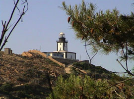
| FR 243 |
| La Pietra (Île Rousse)
latitude 42° 38' 40.3" N longitude 8° 55' 54.9" E
This lighthouse is built on a near-island, connected to the mainland by only a narrow isthmus. The light is the landfall light for Ile Rousse, which is a terminal for ferries from Marseille. Located at the end of the D81A highway about 1 km north of Île-Rousse.
Photo courtesy Iolo [Flickr] |
| FR 244 |
Île Rousse Jetée
latitude 42° 38' 28.4" N longitude 8° 56' 22.7" E
Located at the end of the mole sheltering the ferry terminal of Île-Rousse. Accessible by walking the mole. (E 0928)
Photo courtesy Arno + Evelin Siering [ListOfLights] |
|
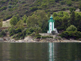
| FR 245 |
| Mortella
latitude 42° 43' 2.9" N longitude 9° 15' 19.4" E
This lighthouse marks the west side of the entrance to the Golfe de Saint-Florent on the north coast of Corsica. High above the lighthouse is a historic signal station (sémaphore). Located on Punta Mortella, about 6 km by sea northwest of Saint-Florent. There does not appear to be any good road access to this location.
Photo courtesy ben7va [Flickr] |
| FR 246 |
Fornali
latitude 42° 41' 19.8" N longitude 9° 16' 46.5" E
This lighthouse is on the west side of the Golfe de Saint-Florent opposite the town of Saint-Florent. There is a road in this area but it's not clear if the lighthouse is accessible. Located about 2.5 km west of Saint-Florent.
Photo courtesy Joseph Panza [camping] |
|
| FR 247 |
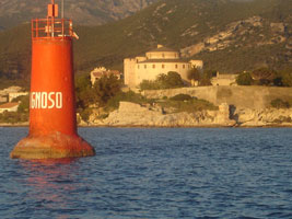
| Tignoso
latitude 42° 40' 56.4" N longitude 9° 17' 38.8" E
in Saint Florent harbor
Photo courtesy Joseph Panza [camping] |
| IT 43 |
Punta del Ferraione
latitude 43° 3' 4" N longitude 9° 50' 39.7" E |
|
|
|
 Southern France
