|
This page shows a portion of Lighthouses of Spain. You can click on the picture of each light to go to it's specific (larger resolution) copy. Each lighthouse is linked to (in our editorial opinion) the best reference site for that light. I would like to include directions on how to get to these lights. If you know such data, could you eMail me and I'll post it here (with your choice of attribution.) mailme There has been significant usage of the Lighthouse Directory prepared by Russ Rowlett (UNC). My thanks to him for providing this basis for understanding. lhDirectory |
|
Huelva
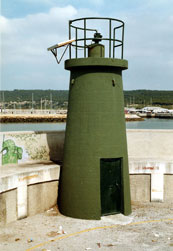
| SP 114 |
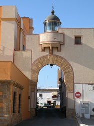
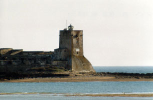
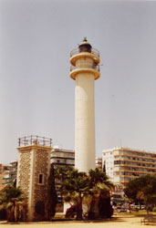
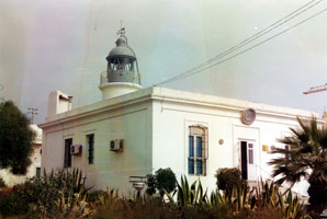
El Rompido (old)
latitude 37° 13' 5.9" N longitude 7° 7' 37.5" W
The light station was built on the west side of the entrance to the Río Piedras and the harbor of El Rompido. Since 1861, Flecha de El Rompido, the barrier sandspit that protects the lower course of the river, has extended itself 8 km to the east, putting the lighthouse that far to the west of the river's mouth. ARLHS # SPA-337
Photo courtesy Beatriz Sirvent [Flickr] |
|
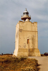
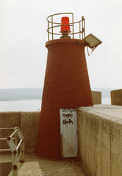
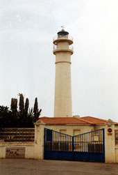
| SP 115 |
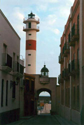
| El Rompido (new)
latitude 37° 13' 6.6" N longitude 7° 7' 36.4" W
In the photo above, you see the new light and in the background, the old light. (D 2312) ARLHS # SPA-271
Photo courtesy Alex Trabas [ListOfLights] |
| SP 116 |
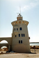
Río Odiel (Dique Juan Carlos I)
latitude 37° 6' 29.3" N longitude 6° 49' 56.6" W
On breakwater at end of spit, entrance to the Río Odiel and port of Huelva. (D 2321) ARLHS # SPA-095
Photo courtesy Adrian Royle [Flickr] |
|
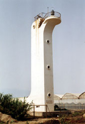
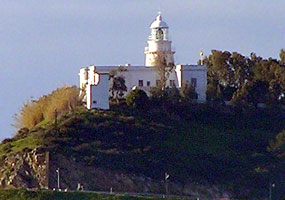
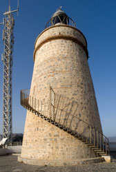
| SP 117 |
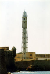
| Picacho (Mazagón)
latitude 37° 7' 57.5" N longitude 6° 50' 4.8" W
This historic light station is the traditional landfall light for the port of Huelva. Located in Mazagón, on the east side of the entrance to the Río Odiel. (D 2320) ARLHS # SPA-185
Photo courtesy Dmitry Rostopshin [rostblog] |
| SP 118 |
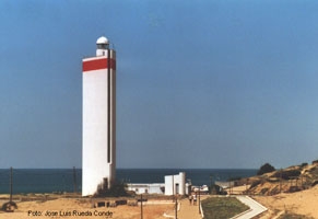
La Higuera (Matalascañas)
On bluff behind beach at Matalascañas, about 35 km southeast of Mazagón. (D 2345) ARLHS # SPA-174
Photo courtesy Jose Luis Rueda Conde [librafaros] |
|
Río Guadalquivir (Sevilla)
| SP 118Q |
| Río Guadalquivir (Sevilla)
Dársena del Batán No. 56 (D 2350)
Photo courtesy Alexander Trabas [ListOfLights] |
| SP 119 |
Bonanza
latitude 36° 48' 14.4" N longitude 6° 20' 12" W
Located at Bonanza, on the east bank of the Guadalquivir about 4 km northeast of Sanlúcar de Barrameda. (D 2346) ARLHS # SPA-073
Photo courtesy Alex Trabas [ListOfLights] |
|
| SP 119F |
| Bonanza Front Range
Río Guadalquivir at Bonanza (D 2348.5) ARLHS # SPA-073
Photo courtesy Alex Trabas [ListOfLights] |
| SP 119R |
Bonanza Rear Range
Located at Bonanza, on the east bank of the Guadalquivir about 4 km northeast of Sanlúcar de Barrameda. (D 2348.51)
Photo courtesy Alex Trabas [ListOfLights] |
|
| SP 120 |
San Jerónimo (Bonanza Range Rear) |
East side of Río Guadalquivir, about ½ mile NE of the Bonanza Range Front Light ARLHS # SPA-340 |
| SP 121 |
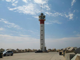
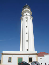
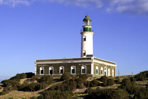
Chipiona (Punta del Perro)
latitude 36° 44' 16.2" N longitude 6° 26' 31.6" W
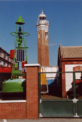
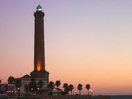
About 5 miles SW of Río Guadalquivir entrance. Lighthouse of the first order, it is the highest of Spain, third of Europe and fifth of the world, it measures 69 m on the level of sea. (D 2351) ARLHS # SPA-301
Photo courtesy Jose Maria Virués de Segovia [Flickr] |
|
Cádiz Area
| SP 122 |
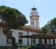
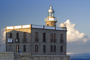
| Rota (old)
The old lighthouse is on the top of the arch by El Duque de Najera Hotel.
Photo courtesy Micah Ciampa [Flickr] |
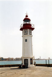
| SP 123 |
Rota (new)
Rota, at the northern entrance to the Bahía de Cádiz, is a major base for the Spanish Navy, but the lighthouse is located on the waterfront of the civilian port. (D 2355.2)
Photo courtesy nicoman [Webshots] |
|
| SP 124 |
| Puerto Sherry
latitude 36° 34' 38.4" N longitude 6° 15' 15.4" W
Located at the end of the breakwater sheltering Puerto Sherry, a large yacht basin at the mouth of the Río Guadalete in El Puerto de Santa Maria. (D 2382) ARLHS # SPA-338
Photo courtesy Hans-Albert Liebetrau [ListOfLights] |
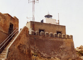
| SP 124A |
Castillo de San Sebastián (Cadiz)
This is the only surviving lighthouse of this type in Spain. The Castillo de San Sebastián was built, starting in the early 17th century, on a small island commanding the approach to Cádiz. (D 2362) ARLHS # SPA-045
Photo courtesy Hans-Albert Liebetrau [ListOfLights] |
|
| SP 125 |
| Sancti Petri
latitude 36° 22' 45.1" N longitude 6° 13' 12" W
Isla de Sancti Petri lies about 1.5 km off the coast at the mouth of the Río Iro. The lighthouse is built on the north side of a circular fortification. Located about 20 km south southwest of Cádiz. (D 2388) ARLHS # SPA-065
Photo courtesy Alex Trabas [ListOfLights] |
| SP 126 |
Cabo Roche
latitude 36° 17' 40.3" N longitude 6° 8' 8.2" W
Located at the point of the cape about 2.5 km south of the town of Cabo Roche. (D 2405) ARLHS # SPA-041
Photo courtesy Alex Trabas [ListOfLights] |
|
Strait of Gibraltar
| SP 127 |
| Cabo Trafalgar
latitude 36° 10' 58.3" N longitude 6° 2' 6" W
The lighthouse is on the point of the cape, about 3 km south of Zahora. (D 2406) ARLHS # SPA-052
Photo courtesy Dmitry Rostopshin [rostblog] |
|
|
| SP 128 |
Barbate
latitude 36° 11' 14" N longitude 5° 55' 59.1" W
Located just off the waterfront in Barbate, a small port and beach resort about 8 km east of Cabo Trafalgar. (D 2408) ARLHS # SPA-071
Photo courtesy Alex Trabas [ListOfLights] |
|
| SP 128A |
| Barbate Dique de Poniente (Barbate Breakwater)
latitude 36° 10' 47.6" N longitude 5° 55' 39.6" W
Located at the end of the main breakwater of Barbate. (D 2409)
Photo courtesy Alex Trabas [ListOfLights] |
| SP 128B |
Barbate Contradique
Located at the end of the east breakwater of Barbate. (D 2410)
Photo courtesy Alex Trabas [liteslist] |
|
| SP 129 |
| Camarinal (Cabo de Gracia)
Located on a high promontory near Camarinal, halfway between Barbate and Tarifa. Access is by a twisting mountain road. (D 2411.5)
Photo courtesy Alex Trabas [ListOfLights] |
| SP 130 |
Punta Paloma
Located on a promontory at the end of provincial road CA-222, about 10 km west of La Peña. (D 2412) ARLHS # SPA-248
Photo courtesy genio21uy [Flickr] |
|
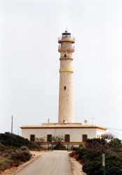
| SP 131 |
| Tarifa
latitude 36° 4.3" N longitude 5° 36' 33.8" W
Tarifa is at the western end of the narrow portion of the Strait of Gibraltar, about 25 km southwest of the Rock and only 14 km northeast of the Moroccan coastline. The lighthouse is on a small island just offshore from the town of Tarifa. Accessible only by boat. (D 2414) ARLHS # SPA-148
Photo courtesy courtecuisse [Webshots] |
EN 232
[73] |
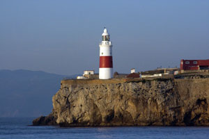
Europa Point (Gibralter)
latitude 36° 6' 34.9" N longitude 5° 20' 41.6" W
November 9, 2007
While technically British, this is at the southern most point of Gibraltar between Cabo Roche and Cabo Trafalgar.
We arrived at 8:00 AM and captured this lovely picture from the deck of Le Diamant. I've got closer pictures from the ground, but thought this best represented the light. (D 2438) |
|
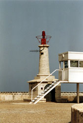
| SP 132 |
| Punta Carnero (Algeciras)
latitude 36° 4' 37.9" N longitude 5° 25' 34.8" W
The lighthouse is similar to the Faro de Chipiona, also designed by Jaime Font. Located on Punta Carnero, about 10 km south of Algeciras on provincial highway CA-223. (I have a photo of this light, but it is so poor we'll keep el orto's photo. It was taken from about where you see the cruise ship.) SP 121 (D 2420) ARLHS # SPA-203
Photo courtesy el orto [Webshots] |
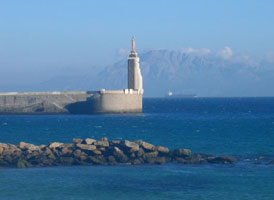
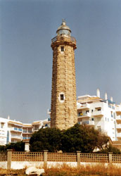
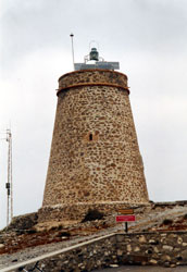
| SP 133 |
Punta Carbonera
latitude 36° 14' 37.4" N longitude 5° 18' 1.5" W
This is another historic watchtower converted into a lighthouse. Located on a bluff facing the Mediterranean about 15 km north of La Linea. (E 0012) ARLHS # SPA-082
Photo courtesy Alex Trabas [ListOfLights] |
|
Melilla
Note that the following lights are actually on the North Coast of Africa. They are inserted here for geographic connectivity, not for political connectivity.
| SP 268 |
| Isla Isabel II (Islas Chafarinas)
Isla Isabel II (or Isabel Segunda) is part of the Chafarinas, a group of three Spanish-controlled islands off the Moroccan coast, about 27 miles east of Melilla. The only inhabitants in the islands are Spanish soldiers posted on Isabel II. Spain's sovereignty over the Charafinas has been contested by Morocco. ARLHS # CEU-001
Photo courtesy Angel Ruiz Migens [Flickr] |
| SP 269 |
Bonete (Melilla)
This lighthouse is part of the historic bastion of Melilla; it is perched on a massive stone foundation rising above the north side of the harbor. ARLHS # CEU-011
Photo courtesy Angel Ruiz Migens [Flickr] |
|
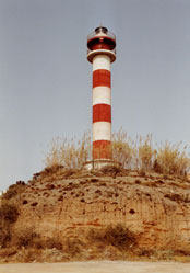
| SP 270 |
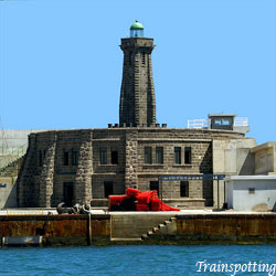
| Melilla Northeast Breakwater
latitude 35° 17' 20.1" N longitude 2° 55' 24.5" W
Located at the end of the breakwater at the north end of the harbor of Melilla. ARLHS # CEU-014
Photo courtesy Trainspotting-Melilla [Flickr] |
| SP 271 |
Peñón de Veléz de la Gomera (Punta San Cristobal)
latitude 28° 5' 41.5" N longitude 17° 6' 0.3" W
The lighthouse is located on a small, Spanish-controlled island on the Moroccan coast. The island's only inhabitants are a Spanish garrison of about 60 soldiers. Spain's sovereignty over the island has been contested by Morocco. (D 2842) ARLHS # CAI-086
Photo courtesy Alexander Trabas [ListOfLights] |
|
Ceuta
| SP 272 |
| Punta Almina
Eastern end of the Strait of Gibraltar, on the Mediterranean coast of Morocco. The city of Ceuta and its immediate surroundings form a Spanish-controlled enclave on the Moroccan coast. Spain's sovereignty over the territory has been contested by Morocco. (D 2482) ARLHS # CEU-007
Photo courtesy Captain Theo [ListOfLights] |
Málaga
| SP 134 |
Punta de la Doncella
The original lighthouse was only 28 ft tall. The keeper's house is the 1863 original, although it has been modified over the years. Located just off the Avenida de España, the seaside boulevard, in Estepona. (E 0020) ARLHS # SPA-212
Photo courtesy Alex Trabas [ListOfLights] |
|
| SP 135 |
| Marbella
Located just off the beach in Marbella. (E 0056) ARLHS # SPA-083
Photo courtesy rickmand [Webshots] |
|
|
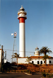
| SP 136 |
Calaburras
latitude 36° 30' 28.5" N longitude 4° 38' 22" W
This lighthouse marks a major cape, where the trend of the coastline changes from east to north northeast. The location is quite conspicuous; the A-7 coastal highway now runs very close to the lighthouse. The present lighthouse replaced a 45 ft masonry tower. Located on the Punta das Calaburras about 4 km south of Fuengirola. (E 0058) ARLHS # SPA-198
Photo courtesy Alex Trabas [ListOfLights] |
|
| SP 137 |
| Málaga Dique de Poniente Extremo (Málaga West Breakwater)
latitude 36° 42' 32.2" N longitude 4° 25' 3.1" W
November 8, 2007
On the breakwater at the west side of entrance to harbor of Málaga. (There are actually several lights of equivalent size and importance in the harbor.) By the time we got to this light, it was impossible to get a photo of it, so this site still uses Alex's research. (E 0066)
Photo courtesy Alex Trabas [ListOfLights] |
| SP 137A |
Málaga Dock Red
latitude 36° 42' 4" N longitude 4° 25' 5.8" W
This light is on the side of the main water break and probably is intended to balance the light below (so boats go between them). Note that it doesn't follow the US pattern of 'Red Right Returning' as it's on the starboard side as we exited.
The photo was taken at 11:15 in the evening, hand held with about a 3 second exposure as the boat moved by it. I'm surprised anything came out. (E 0064.5) |
|
| SP 137B |
| Málaga Dock End
latitude 36° 41' 56.1" N longitude 4° 24' 52.9" W
This light basically marks the end of the dock. It looks like there are mooring spots on both sides and the captain just has to pick the correct side (not the middle) in order to port safely. (E 0064.6) |
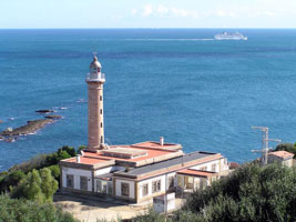
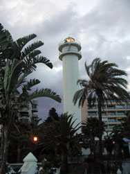
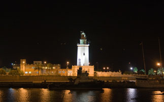
| SP 138 |
Málaga ('La Farola')
latitude 36° 42' 50.6" N longitude 4° 24' 52" W
November 8, 2007
Floodlit at night, it is a familiar symbol of the city's waterfront. Located on the Paseo Farola on the east side of the harbor of Málaga.
This photo is taken just after we've boarded Le Diamant at 7:30 PM. (A 0062) ARLHS # SPA-0302 |
|
| SP 139 |
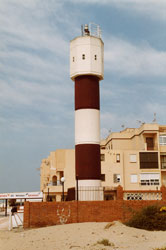
| Torre del Mar (1969)
latitude 36° 44' 6.6" N longitude 4° 5' 47.4" W
By the late 1960s, rapid beachfront development had rendered the 1930 lighthouse useless, so this small tower was built near the ocean beach as a stopgap measure. Located in front of the modern lighthouse. (E 0072)
Photo courtesy Heike + Friedrich Klatt [ListOfLights] |
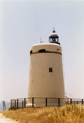
| SP 140 |
Torre del Mar (1974) |
Located on the waterfront of Torre del Mar, about 32 km east of Málaga and about 1.8 km east of the Río Vélezas
The 1969 light is the small square 'box', the new lite is the tall tower.
Photo courtesy Alex Trabas [liteslist] |
| SP 141 |
Punta de Torrox
latitude 36° 43' 35.5" N longitude 3° 57' 26.4" W
Located on a promontory above the beach at Torrox-Costa, 4 km south of Torrox. (E 0074) ARLHS # SPA-219
Photo courtesy Heike + Friedrich Klatt [ListOfLights] |
|
Granada
| SP 142 |
| Punta de la Mona (La Herradura, Torre de los Berengueles)
Located on a high, rocky promontory at Punta de la Mona, between the popular beaches of La Herradura and Almuñécar. (E 0074.8) ARLHS # SPA-289
Photo courtesy Miguel Angel Almendros Caro [Flickr] |
| SP 143 |
Cabo Sacratif
latitude 36° 41' 40.2" N longitude 3° 28' 6" W
Located just off the coastal highway N-340 on a high promontory, the Cerro del Chucho, about 9 km southeast of Motril. (E 0080) ARLHS # SPA-042
Photo courtesy Heike + Friedrich Klatt [ListOfLights] |
|
| SP 144 |
| Punta del Melonar (Castell de Ferro, Torre de la Instancia)
latitude 36° 43' 2.9" N longitude 3° 22' 6.1" W
This, Spain's second highest light, is another historic watchtower renovated into a lighthouse. Located atop a sharp peak above the coast on the southwest side of Castell de Ferro. (E 0082) ARLHS # SPA-060
Photo courtesy Alex Trabas [ListOfLights] |
Isla de Alborán
| SP 145 |
Isla de Alborán
latitude 35° 56' 17.4" N longitude 3° 2' 8.4" W |
about 30 miles due north of Cap des Trois Fourches (Morocco) and 45 miles south of the Spanish town of Adra. The lighthouse is the sole building on this small, Spanish-controlled Mediterranean island, which is now a marine reserve. F.J.A. Delgado has posted a photo of the lighthouse with the new lantern. photo (E 0086) |
Almería
| SP 146 |
Adra (1899) |
The first Adra light, a 43 ft hexagonal wooden tower, was built near the former mouth of the Río Adra; it was quickly threatened by erosion and collapsed during a storm in 1896. The light was then moved to a safer location about 3 km to the west. The lighthouse was repaired after being damaged during the Spanish Civil War in the 1930s. ARLHS # SPA-334 |
| SP 147 |
Adra (1986)
latitude 36° 44' 52.6" N longitude 3° 1' 51.5" W
Located just off the old coastal road (highway N-340A) on the west side of Adra. (E 0088) ARLHS # SPA-068
Photo courtesy Alex Trabas [ListOfLights] |
|
| SP 149 |
Sabinal (Punta Sabinar)
latitude 36° 41' 12.5" N longitude 2° 42' 4.3" W
Located in El Sabinal, an area of dunes and wetlands south of San Agustín, at the western entrance to the Golfo de Almería. (E 0090)
Photo courtesy Alex Trabas [ListOfLights] |
|
| SP 150 |
| Roquetas de Mar
latitude 36° 45' 11.7" N longitude 2° 36' 22.5" W
The lighthouse was abandoned because of changes to the harbor, and because it was too short to show up well against the lights of the town. It was replaced by lights on the breakwaters. Located on the waterfront on the south side of the harbor of Roquetas de Mar. (E 0092) ARLHS # SPA-298
Photo courtesy Ayuntamiento de Roquetas de Mar. |
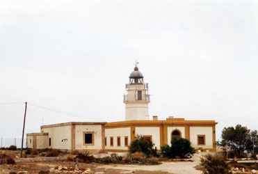
| SP 151 |
Almería (Castillo de San Telmo)
latitude 36° 49' 52.6" N longitude 2° 30' 1" W
The castle was built in the late 18th century. Located on heights on the west side of Almería, above Castell del Rey. (E 0093)
Photo courtesy Alex Trabas [ListOfLights] |
|
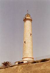
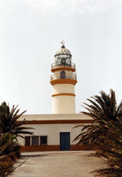
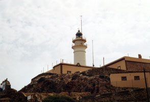
| SP 153 |
Cabo de Gata
latitude 36° 43' 18.3" N longitude 2° 11' 34.7" W
The wild area surrounding the cape is now included in a national park. Located on the southernmost point of the cape. (E 0106)
Photo courtesy Ian Wright [ListOfLights] |
|
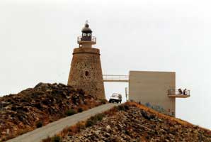
| SP 154 |
| Punta de la Polacra
This tower was built as a watchtower in 1767; a light was added in 1991. This is the highest light above sea level in Spain. The lighthouse is within the Parque Natural de Cabo de Gata-Nijar. (E 0107)
Photo courtesy Alex Trabas [ListOfLights] |
| SP 155 |
Mesa Roldán
The light at Punta de la Polacra is higher, but this historic lighthouse has a much greater range of 27 miles. Located atop a high cliff about 8 km south of Carboneras. (E 0108)
Photo courtesy Alex Trabas [ListOfLights] |
|
| SP 156 |
| Garrucha
Located on the waterfront of Garrucha, near the south end of town. (E 0110)
Photo courtesy Alex Trabas [ListOfLights] |
|
|
 Portugal
 East Spain