|
Copies of these pictures are stored on the Web if you want to download them. The lights in Lake Ontario are numbered starting in the West at Fort Niagara, then going counter-clockwise, thus first the Southern shore, then a stretch of the St. Lawrence River, then the Northern Shore, and finally ending up at the Niagara River in Ontario The pictures below are 'live', if you click on one, it will take you to that photo (or one very similar) on webshots which will be with much better resolution and available for downloading. Index numbers on this page are from Great Lakes Lighthouses American& Canadian Wes Oleszeski, Avery Press, 1998 P1 |
|
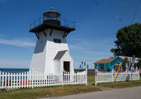
| 1 |
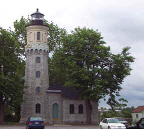
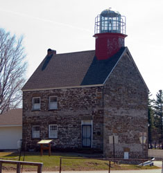
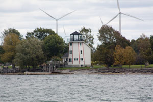
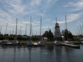
Fort Niagara (NY 8)
latitude 43° 15' 42.5" N longitude 79° 3' 37.5" W
June 16, 2002 access: car
Fort Niagara; Built in 1872 out of local limestone; this is no longer in use (thus the trees which conceal it pretty well from the water). It was taken out of service in 1993.
Take the Robert Moses Parkway as north to the Fort Niagara State Park. ARLHS # USA-294 |
|
| 2 |
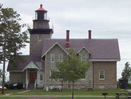
| Thirty Mile Point (NY 9)
latitude 43° 22' 29.7" N longitude 78° 29' 9.1" W
June 16, 2002 access: car
This light was in use from 1875 to 1958 when it was replaced by a steel tower nearby (no picture available)
Take Lake Road (NY 18) east from Fort Niagara 30 miles to Golden Hill State park. ARLHS # USA-844 |
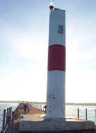
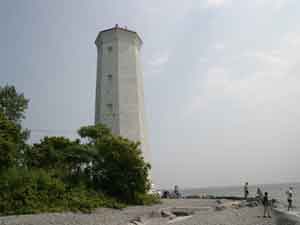
| 3 |
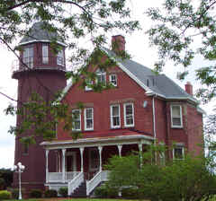
Braddock Point (NY 10)
June 16, 2002 access: car
This has recently been resold and it is in the process of being opened for viewing. It's nearly a duplicate of a light that was in Cleveland OH from 1829 to 1895. The original tower was 110' tall but had extensive damage so the owners only restored the essence rather than the complete tower.
North of Rochester; take the Lake Ontario State Parkway east to NY 222 (Lighthouse Road). Turn left on Clearview avenue and you'll find the light on the lake side. ARLHS # USA-075 |
|
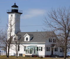
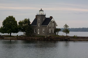
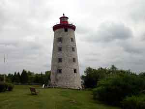
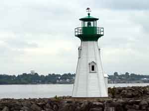
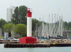
| 4 |
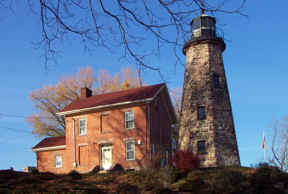
| Charlotte Genesee 1822 Lighthouse (NY 11)
latitude 43° 15' 9.7" N longitude 77° 36' 38.5" W
November 23, 2001 access: car
This lighthouse is on the west side of the Genesee River at its connection to Lake Ontario. It is built on the site where Indians used to camp and where the William Hincher family settled in 1792. ARLHS # USA-320 |
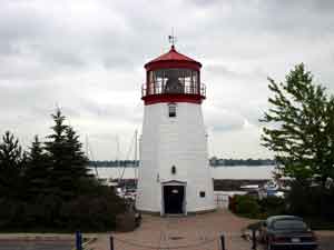
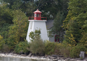
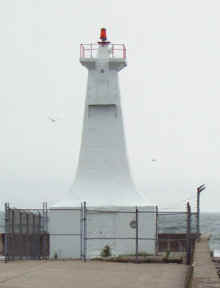
| 5 |
Rochester Harbor (NY 12)
latitude 43° 15' 45" N longitude 77° 35' 52.8" W
November 23, 2001 access: car
This is the modern Rochester lighthouse. Like all the modern ones it is fully automated; and shows a good case of terminal "uglies". ARLHS # USA-322 |
|
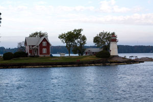
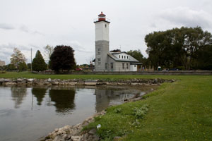
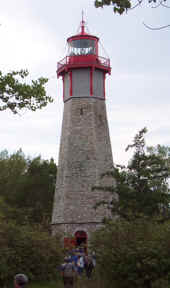
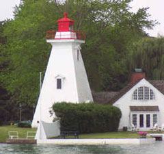
| 6 |
| Old Sodus Point (NY 13)
latitude 43° 16' 25.6" N longitude 76° 59' 10.9" W
April 11, 2006 access: car
This light was constructed in 1870 (replacing an older light from 1825). The light is hard to find
unless you start from the light below and look due West (the picture on the right is that view (with the long lens)). It is now a museum although the keepers house was used by the Coast Guard till 1984 (the light was decommissioned in 1901). ARLHS # USA-765 |
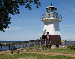
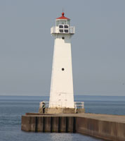
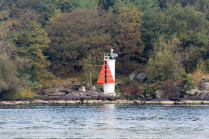
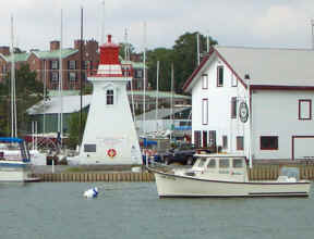
| 7 |
Sodus Outer (NY 14)
latitude 43° 16' 37.9" N longitude 76° 58' 26.4" W
April 11, 2006 access: car
This light also was established in 1870. It is on the very end of the channel that lets boats into Sodus Bay. ARLHS # USA-766 |
|
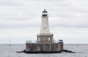
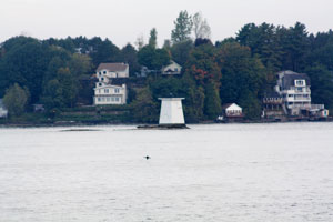
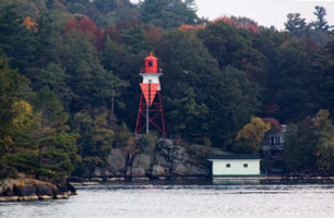
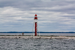
| 8 |
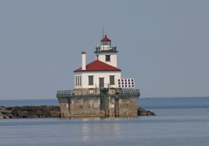
| Oswego West Pierhead (NY 15)
latitude 43° 28' 23.8" N longitude 76° 31' 0.3" W
April 11, 2006 access: boat
This light is quite a ways from shore; so the best way to see it is to use a boat. However; a long lens allows some of us to avoid swimming and make it look like we were really pretty close. ARLHS # USA-571 |
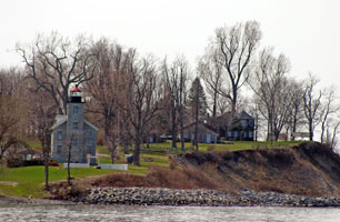
| 9 |
Selkirk (Point Ontario) (NY 16)
latitude 43° 34' 26.5" N longitude 76° 12' 8" W
April 11, 2006 access: car
If you're interested; this light (and the adjacent Marina) is for sale. Note that it has the original "bird cage" housing for the light. All the other lights were upgraded in the 1850's but since this light was decommissioned in 1858 it was not upgraded.
To get here; follow NY 3 to County Road 5; the go to the end. ARLHS # USA-719 |
|
| 10 |
| Stony Point (NY 17)
latitude 43° 50' 20.8" N longitude 76° 17' 56.4" W
April 11, 2006 access: car
Once again this light is now a private residence. It was erected in 1869 (replacing a light built in 1830) but deactivated in 1945.
From NY 3; take Military Rd on the south side of Henderson Harbor to Lighthouse Road. (As you might expect; take this to the end.) Please respect their privacy and stay on the public road. (Don't confuse this with the Stony Point on the Hudson River.) NY38 ARLHS # USA-814 |
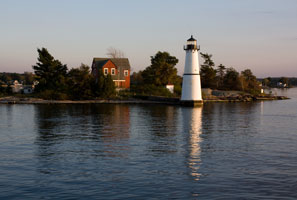
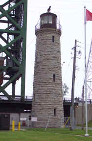
| 11 |
Galloo Island (NY 18)
latitude 43° 53' 16.7" N longitude 76° 26' 43.3" W
access: boat
The island is about 12 miles from historic Sackets Harbor, New York, about 10 miles from Henderson Harbor. ARLHS # USA-314
Photo courtesy Bob Indrums [Flickr] |
|
| 12 |
| Horse Island (Sackets Harbor) (NY 19)
latitude 43° 56' 33.4" N longitude 76° 8' 40.8" W
access: boat
On tiny Horse Island just a hundred yards or so offshore from Sackets Harbor. Foliage hides the lighthouse however. ARLHS # USA-380
Photo courtesy Rebecca Adams [Webshots] |
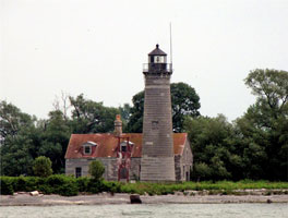
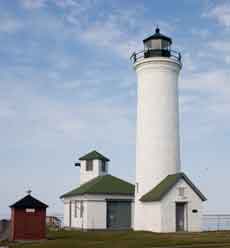
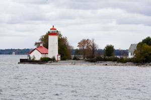
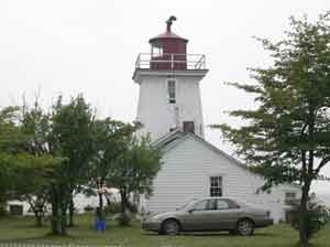
| 13 |
Tibbetts Point (NY 20)
latitude 44° 6' 2.3" N longitude 76° 22' 13.8" W
April 11, 2006 access: car
This light marks the entrance to the St. Lawrence River. There was a light here in 1827 made out of rubble stone; this light was erected in 1854. It now serves as a youth hostel. This photo shows the light; then (moving to the left) the fog horn building; finally the fuel storage building (which now is a paint shed). ARLHS # USA-848 |
|
| 14 |
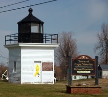
| Cape Vincent Breakwater (relocated) (NY 21)
latitude 44° 7' 10.3" N longitude 76° 19' 55.9" W
April 11, 2006 access: car
Once (?-1934) mounted on the breakwater of Cape Vincent; this light has now been moved to front the village offices.
It can easily be seen if one takes route 12E into Cape Vincent. ARLHS # USA-141 |
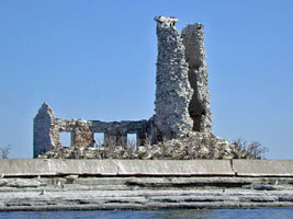
| 15 |
East Charity Shoal (ruins) (NY 22)
latitude 44° 2' 21.9" N longitude 76° 28' 46.6" W
October 1, 2009 access: boat
This light can be seen with binoculars from Tibbets Point; but for a good view a boat or plane ride is required. The light originally was at Vermillion Ohio. We saw the light from the water on a GLLKA tour ARLHS # USA-970 |
|
|
|
| 16 |
| Rock Island (NY 23)
latitude 44° 16' 50.4" N longitude 76° 1' 1.5" W
October 3, 2009 access: boat
Located in the Thousand Islands about 4.5 miles northeast of Clayton; Jefferson County; New York; off of Fisher's Landing. While only accessible by private boat; the grounds are open for touring and picnicking. ARLHS # USA-697 |
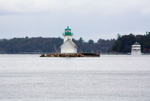
| 17 |
Sunken Rock (NY 24)
latitude 44° 20' 45.8" N longitude 75° 54' 40.4" W
September 30, 2009 access: car
This lighthouse can be seen from the shore in Alexandria Bay. The lighthouse can also be seen from tour boats out of Alexandria Bay; Clayton; or Canada. ARLHS # USA-828 |
|
| 18 |
| Sisters Island (NY 25)
latitude 44° 24' 51.7" N longitude 75° 50' 38.9" W
October 3, 2009 access: boat
Tours are now offered to Singer Castle; which is located downriver from Sisters Island; so the tour boats must pass by the lighthouse and offer some kind of view. ARLHS # USA-760 |
| 19 |
Crossover Island (NY 26)
latitude 44° 29' 49" N longitude 75° 46' 42" W
October 3, 2009 access: car
From NY-12; 4.1 miles northeast of Chippewa Bay (if you are traveling from the south) and 2.5 miles southwest of Oak Point Road (if you are traveling from the north); turn onto an unmarked road (toward the river) which leads immediately to Riverledge Road. Turn right; and look for the lighthouse on the river. ARLHS # USA-206 |
|
| 19.3 |
| Cole Ferry Shoal (ON 14C)
latitude 44° 31' 59.3" N longitude 75° 45' 33.3" W
October 3, 2009 access: boat
This light has been abandoned; lost it's lantern; lost it's ferry; so all that remains is the base. It's included only to help others traveling the river to identify it. |
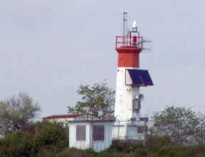
| 19.4 |
de Watteville Front (ON 14F)
latitude 44° 32' 51.5" N longitude 75° 44' 1.4" W
October 3, 2009 access: boat
Before modernization, this was a quot;real" lighthouse. After modernization, there still is a cupola on top of the daymark, so I have chosen to include it. This range marks the northern entrance to Brockville Narrows and is only visible from a boat |
|
| 19.6 |
| de Watteville Rear (ON 14R)
latitude 44° 33' 0.5" N longitude 75° 43' 52" W
October 3, 2009 access: boat
Normally a simple sewer pipe light like this would not be included in this index (there are a million or so lights like this on the St. Lawrence.) This light is included only to match the light below. ARLHS # CAN-1170 |
| 20 |
Ogdensburg Harbor (NY 27)
latitude 44° 41' 52.3" N longitude 75° 30' 12.4" W
access: car
From NY-37; exit onto NY-68 (Canton St.). From Canton Street; turn right onto State Street to the riverfront. Turn left on Riverside Avenue and drive one block to a park. The lighthouse is on the opposite side of the Oswegatchie River. This is privately owned so permission is needed to gain access. ARLHS # USA-562 |
|
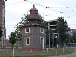
| 21 |
| Windmill Point (ON 15)
latitude 44° 43' 16" N longitude 75° 29' 13.9" W
July 13, 2004 access: car
This really was built as a windmill; and a very famous battle called the Battle of the Windmill was fought here (in 1837). It was rebuilt as a light house in 1846 and served until 1965. ARLHS # CAN-534 |
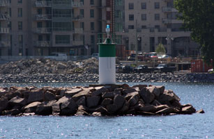
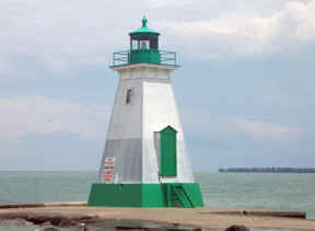
| 22 |
Prescott Breakwater (ON 16)
latitude 44° 42' 36" N longitude 75° 30' 34.6" W
July 13, 2004 access: car
This light marks the entrance to the city marina. I'd guess that the weather's bad enough that you need the light; you shouldn't be out in this size boat. ARLHS # CAN-767 |
|
| 23 |
| Prescott Visitor's Center (ON 17)
latitude 44° 42' 37.3" N longitude 75° 30' 42.3" W
July 13, 2004 access: car
This is a replica of a lighthouse. It contains a Fresnel lens (that looks big enough to be a level 3) donated by the Canadian Coast Guard. If you'd like to donate; there's some nice people inside that will assist you in that endeavor. |
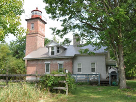
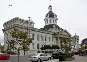
| 24 |
Nine Mile Point (ON 18)
latitude 44° 9' 5.5" N longitude 76° 32' 55.2" W
June 23, 2008 access: car
In Kingston Ontario; follow Highway 2 (Princess St.) to the end (Ontario St.). Turn left and then right at the Wolfe Island Ferry. The car ferry is free. Take the ferry to Wolfe Island. Exit the ferry in Marysville onto Highway 95 and make an immediate right onto Highway 96. Drive 3.5 miles and turn right onto a gravel road at the cable ferry dock to Simcoe Island. Take the very small cable ferry to Simcoe Island. (There is a fee for the cable ferry.) From there; follow Simcoe Island's only main road to the lighthouse. The land is private so bring your long lens or ask permission for access. ARLHS # CAN-758 |
|
| 24.1 |
| Pigeon Island (ON 18C)
latitude 44° 3' 58.5" N longitude 76° 32' 59.9" W
October 1, 2009 access: boat
This is a relatively small skeletal structure; and somehow is not listed in Wes' book. It is located on a very small island 5 miles west of Bear Point (which is on Wolfe Island.) |
|
|
| 24.2 |
Snake Island Shoal (ON 18H)
latitude 44° 11' 3.4" N longitude 76° 30' 49.6" W
October 2, 2009 access: boat
This replica of the Snake Island light is located on Wolfe Island. It is fairly accurate except for the lantern area. Snake Island Shoal was built in 1858; moved twice and burned to the ground in 1958. |
|
| 24.3 |
| Knapp's Point (ON 18K)
latitude 44° 13' 57.5" N longitude 76° 24' 56.4" W
October 1, 2009 access: boat
This light was deactivated in 2000 and is now in private ownership. As you can see from the photo it is becoming overgrown. While the light is on Wolfe Island, the best viewing is from the water |
| 24.7 |
Kingston Marina (ON 18M)
latitude 44° 13' 34.7" N longitude 76° 28' 38.4" W
June 23, 2008 access: ferry
This light is clearly visible from the Wolfe Island ferry as you leave Kingston. Clearly not a lighthouse; it does protect boats entering the marina. |
|
| 24.8 |
| Kingston Ferry Dock (ON 18Q)
latitude 44° 13' 56.2" N longitude 76° 28' 34" W
June 23, 2008 access: car
The Wolfe Island Ferry runs until 1AM in the summer; and all year long. This light marking the end of the pier is a good idea. However, the size means that it won't make many other lighthouse lists. |
| 24.9 |
Kingston City Hall (ON 18T)
latitude 44° 13' 47.5" N longitude 76° 28' 50" W
October 1, 2009 access: car
Althought never technically listed as an aid to navigation; navigators have used the illuminated dome of the city hall as a guide to the harbor for years. |
|
| 25 |
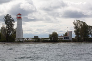
| Main Duck Island (ON 19)
latitude 43° 55' 51.4" N longitude 76° 38' 19.1" W
October 1, 2009 access: boat
We saw this light as part of the Ontario GLLKA cruise. The light is accessible only by boat, and is not visible from the mainland. There is a reef running in line with this point, so navigation is tricky; but deep water next to that reef so we got a good view. ARLHS # CAN-760 |
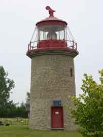
| 26 |
False Duck Island (Old) (ON 20)
latitude 43° 54' 35.2" N longitude 77° 2' 33.3" W
July 12, 2004 access: car
This actually is a re-creation. This light was built in 1967. This ligh, like the next 5, are all in Prince Edward County; just south of 401; but there's a whole lot of Canada between them. ARLHS # CAN-864 |
|
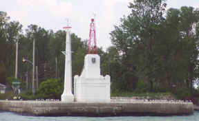
| 27 |
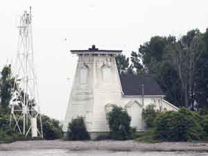
| Prince Edward Point (ON 21)
July 12, 2004 access: car + long lens
This light is on the very eastern point of Prince Edward County. As you can see, the original light is defunct, but they have erected a new steel skeleton in front to hold the replacement automated light. ARLHS # CAN-787 |
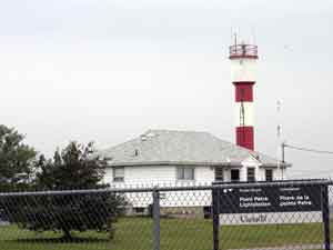
| 28 |
Point Petre (ON 22)
latitude 43° 50' 21.6" N longitude 77° 9' 8.3" W
July 12, 2004 access: car
This light is on the opposite end of Prince Edward County, and it seems like it is only gravel roads separating these 2 lights. This is a research facility, so this picture is about as close as you can get to it. ARLHS # CAN-763 |
|
| 29 |
| Salmon Point (ON 23)
latitude 43° 50' 58.9" N longitude 77° 9' 43.5" W
July 12, 2004 access: boat
This light is inside a private campground, and rented by the week. It looked like we were not even going to be able to get near it, but a resident drove up, let us through the gate, and we talked to Mrs. Rankin. She finally let me in (less $10 Canadian) and wanted to know how many millions of dollars I was going to make off these pictures. (My guess is not many) ARLHS # CAN-789 |
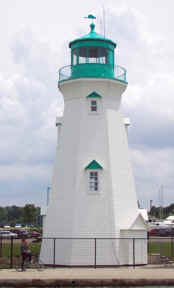
| 30 |
Presqu'le Point (ON 24)
July 12, 2004 access: car
This light has lost it's top (as you can see), but there is still one of the solar powered bulbs up there (almost impossible to see in this picture). ARLHS # CAN 412 |
|
| 31 |
| Toronto Harbor Aquatic Park (ON 25)
latitude 43° 36' 50.4" N longitude 79° 20' 35.5" W
June 15, 2002 access: boat
You can reach this lighthouse by car then a long walk or you can go on a Great Lakes Lighthouse Keepers Ontario cruise and see it from the water. We did the latter. ARLHS # CAN-1340 |
| 31.1 |
Mimico [Yachting Club] (ON 25A)
latitude 43° 37' 5.2" N longitude 79° 28' 53.2" W
access: car
Photo courtesy Gary J. Wood [Flickr] |
|
| 32 |
| Gibraltar Point (ON 26)
latitude 43° 36' 43.9" N longitude 79° 23' 18.6" W
June 15, 2002 access: boat
This is the oldest standing lighthouse on the Great Lakes; dating from 1808. It was active until 1958 and is now under loving care. ARLHS # CAN-199 |
| 33 |
Queen's Wharf (ON 27)
latitude 43° 38' 8.9" N longitude 79° 24' 17.6" W
July 11, 2004 access: car
Driving into Toronto, the wrong way because we got trapped in the express lanes of 401, we drive right by this and say "we've got to go back ... later". So after dinner; I went back; it was a quiet Sunday night; and easy to find. ARLHS # CAN-542 |
|
| 34 |
| Oakville (ON 28)
latitude 43° 26' 30.3" N longitude 79° 40' 10.1" W
June 14, 2002 access: car
Built in 1837, rebuilt in 1889, this light was removed from its working place in 1960 and now is part of a marina in downtown Oakville. ARLHS # CAN-632 |
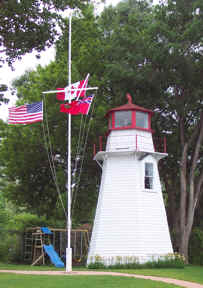
| 34.1 |
Oakville (new) (ON 29)
latitude 43° 26' 22" N longitude 79° 39' 55.5" W
June 16, 2002 access: boat
The Oakville light has been replaced by the modern monstrosity shown on the right. In theory, you can see the old light from the water; but it takes very sharp eyes and a different point of view than this one. ARLHS # CAN-633 |
|
| 35 |
| Burlington Canal Front Range (ON 30)
latitude 43° 18' 3.6" N longitude 79° 47' 26" W
June 14, 2002 access: car + walk
Still in operation at the tip of the Burlington Canal; this light was first built in 1832; but was replaced in 1909 with this concrete structure that looks Art Deco. ARLHS # CAN-618 |
| 36 |
Burlington Canal Rear Range (ON 31)
latitude 43° 17' 54.5" N longitude 79° 47' 42.8" W
June 15, 2002 access: car or boat
Originally the rear light leading boats into the Burlington Canal; this light is now blocked by the East Port lift bridge and has pretty much been ignored. ARLHS # CAN-063 |
|
| 37 |
| Port Dalhousie Front Range (ON 32)
latitude 43° 12' 39.7" N longitude 79° 15' 48.4" W
June 15, 2002 access: car
You can pronounce the port's name Daloosie or Dal-Hoosie depending on what part of Canada you're from. The local's prefer the former. Built in 1879 to protect the then end of the Welland Canal, it was automated in 1968 and still active (but only for the harbor). ARLHS # CAN-540 |
| 38 |
Port Dalhousie Rear Range (ON 33)
latitude 43° 12' 24.8" N longitude 79° 15' 47.4" W
June 15, 2002 access: car
This is the rear end of the range. Both lights; while active; were in poor repair. As you can see, they have recently been picked up by a local group for renovation and are in excellent shape. ARLHS # CAN-541 |
|
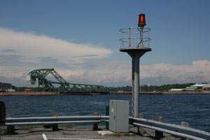
| 39 |
| Port Weller Outer (ON 34)
latitude 43° 14' 40.6" N longitude 79° 13' 3.5" W
June 15, 2002 access: boat
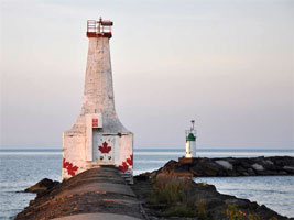
Port Weller is the end of the Welland Canal (now). This used to be the fog horn when the light was located 1/2 mile up the barrier. It now is the light and fully automated. ARLHS # CAN-766 |
| 40 |
Niagara River Front Range (ON 35)
latitude 43° 15' 19.8" N longitude 79° 3' 42.3" W
June 15, 2002 access: boat
Built on the Canadian side of the Niagara River in 1903; this pair of lights will lead boats up the river. ARLHS # CAN-620 |
|
| 41 |
| Niagara River Rear Range (ON 36)
latitude 43° 15' 13.8" N longitude 79° 3' 37.7" W
June 15, 2002 access: boat
This is the other half of the light above. ARLHS # CAN-621 |
|
|
If you would like copies of any of my pictures, contact me and we'll discuss arrangements. There are others who do this commercially, I have no intention of competing directly, but you can make a proposal, and I'll react. mailto
 Lake Erie