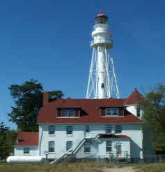
|
Here's the Western side of Lake Michigan. Note that it's now augmented by a visit in 2003 (after stopping overnight with Michael) and another visit in 2004, but is still missing a "bunch" of lighthouses (mostly those accessible only by boat). Downloadable copies of this pictures are stored on the web (Flickr). The pictures below are "active", if you press on one, you'll be directly connected to the site with that picture (or one very similar) at a much higher resolution. Album Orange numbers in parenthesis are references to the Shanklin List of all US lights. p2 Index numbers are taken from Great Lakes Lighthouses, American and Canadian p1 |
|
| 47.5 |
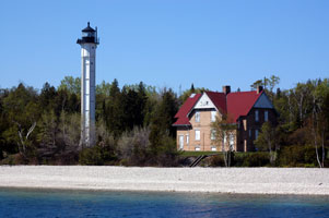
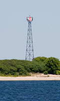
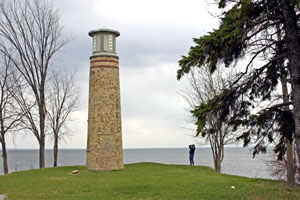
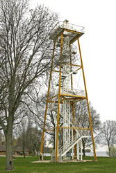
Kevitch (Private Aid to Navigation) (WI 38K)
latitude 43° 19' 24.7" N longitude 87° 53' 18.3" W
access: boat
Privately built by the Kevich family, this lighthouse has the highest focal plane of any active U.S. Great Lakes lighthouse; Boyer Bluff Light (above) is the only higher navigational aid on Lake Michigan. Located a top a high bluff on Lake shore Road a short distance north of Ulao Road, in the town of Grafton, about 4 miles south of Port Washington.
There is no good access to the light from the land. ARLHS # USA-1066
Photo courtesy Ann Stibor [Flickr] |
|
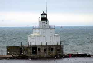
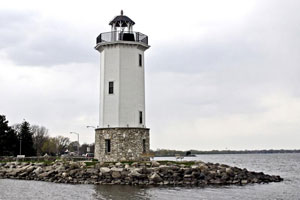
| 48 |
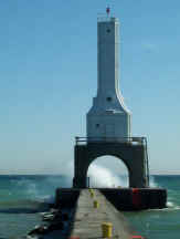
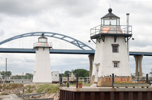
| Port Washington North Breakwater (WI 38)
latitude 43° 23' 7" N longitude 87° 51' 34.8" W
September 29, 2000 access: car
Built in an Art Deco style, this lighthouse is 1800' from the shore (nicely marked out in 100' intervals all the way out the breakwater) ARLHS # USA-653 |
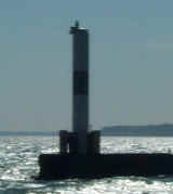
| 48.1 |
Port Washington South Breakwater (WI 38A)
latitude 43° 23' 4.1" N longitude 87° 51' 39" W
September 29, 2000 access: car
This is the other side of the entrance way. No where near as pretty, but a light [house] and not in the book. ARLHS # USA-654 |
|
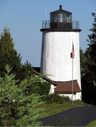
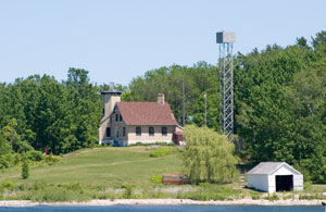
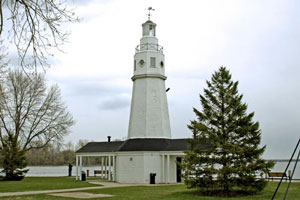
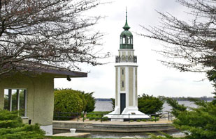
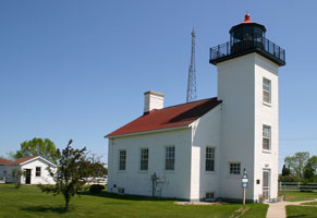
| 49 |
| Old Port Washington Harbor (WI 38B)
latitude 43° 23' 27.5" N longitude 87° 52' 3.9" W
June 11, 2004 access: car
This is the original light for the lights shown above. Established in 1849, and this light built in 1860, it was active till 1935 when the pierhead light was built. The "light" on the top is a recent reconstruction, without that it looked more like a warehouse. It's currently a museum. ARLHS # USA-652 |
| 49.1 |
Sheboygan Breakwater (WI 37)
latitude 43° 44' 58.2" N longitude 87° 41' 33.7" W |
From I-43, take Kohler Drive east to its end at 4th Street in downtown Sheboygan. Turn south on 4th street to Niagara. Turn east on Niagara to Broughton Drive. turn south on Broughton to Wisconsin Ave. Turn east on Wisconsin and enter the marina parking lot. The breakwater is a long walk. ARLHS # USA-1241 |
| 50 |
Manitowoc Breakwater (WI 36)
latitude 44° 5' 31.6" N longitude 87° 38' 34.8" W
June 10, 2004 access: ferry
The lighthouse is built on top of the fog alarm, so looks much like a wedding cake. The picture is taken from the rear deck of the SS Badger on our way into Manitowac. ARLHS # USA-471 |
|
| 51 |
| Two Rivers North Pierhead (WI 35)
September 29, 2000 access: car
This actually is only the top of a now inactive lighthouse. It's part of a museum on Great Lakes. ARLHS # USA-862 |
| 52 |
Rawley Point (WI 34)
latitude 44° 12' 38.4" N longitude 87° 30' 32.5" W
September 29, 2000 access: car
Although the site was established in 1853, this lighthouse was moved here from Chicago in 1894. It's the tallest skeletal steel tower lighthouse. ARLHS # USA-689 |
|
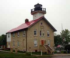
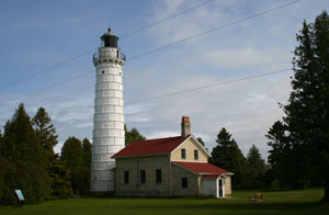
| 53 |
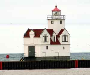
| Kewaunee Pierhead (WI 33)
latitude 44° 27' 26.2" N longitude 87° 29' 35.5" W
June 10, 2004 access: car
While this looks like a full home, it really is just an housing for the fog horn, and an automated light. Allegedly a duplicate of Big Red in Holland, with the color differences, it's really hard to compare because of the major differences in color. BigRed ARLHS # USA-417 |
| 54 |
Algoma Pierhead (WI 32)
latitude 44° 36' 24.8" N longitude 87° 25' 45.9" W
June 10, 2004 access: car
We were told to use a boat to get to this one. This picture is taken from the shore with the long lens but not using all of it. If you're willing to walk out the south pierhead (the lighthouse is on the north side), you wouldn't need to be George Washington to throw a silver dollar at it.
ARLHS # USA-004 |
|
| 55 |
| Sturgeon Bay Ship Canal (WI 30)
latitude 44° 47' 42" N longitude 87° 18' 48" W
June 10, 2004 access: car
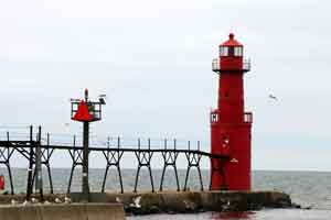
While Sturgeon Bay is on the West Side of Door County, the boats travel the east side in the middle of Lake Michigan. So they cut a canal through the peninsula, but clearly needed to mark it well. This light (and the one below) illuminate the passageway for sailors. ARLHS # USA-821 |
| 56 |
Sturgeon Bay Ship Canal N. Pierhead (WI 31)
latitude 44° 47' 31.4" N longitude 87° 18' 33.8" W
June 10, 2004 access: car
For some reason (probably a need to load supplies), there's a Pier right by the canal. This light illuminates the Pier. The building also contains a fog horn, so it is larger than just the light requires.
Note carefully the height of the catwalk. During heavy storms, this area can get very wet. ARLHS # USA-822 |
|
|
|
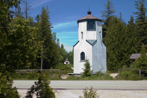
| 57 |
| Baileys Harbor (old) (WI 28)
latitude 45° 3' 21" N longitude 87° 5' 49.4" W
June 9, 2006 access: car
Built in 1851, the lake Captains didn't like the placement of this light. In 1869, it was replaced with the range lights shown below and has been abandoned. Note however the "bird cage" shelter for the light itself. This is the original, and one of only 3 on the great lakes. (To get to this light, follow the road that passes by the range lights below as far as it will go, and bring a long lens.) ARLHS # USA-026 |
| 58 |
Baileys Harbor Front Range (WI 29)
latitude 45° 4' 13.4" N longitude 87° 7' 10.6" W
June 9, 2006 access: car
The replacement for the light above was a pair of lights, arranged in a range formation (the captain lined the two lights up so that they were atop each other, then follows that into the harbor). What's most interesting is that the front range appears to be a duplicate of the Front Range at Presque Isle Michigan. ARLHS # USA-936 |
|
| 58.5 |
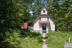
| Baileys Harbor Rear Range (WI 29R)
latitude 45° 4' 22.1" N longitude 87° 7' 15.4" W
June 9, 2006 access: car
At the end of a very long walkway is this other light, which today is a nature preserve office and sometimes private residence. Once again, it seems to be a duplicate, but this time of the light at Copper Harbor (also in Michigan, but on Lake Superior) MI12 ARLHS # USA-027 |
| 59 |
Cana Island (WI 27)
latitude 45° 5' 17.9" N longitude 87° 2' 57.1" W
June 10, 2004 access: car
The Cana Island light is a complement to the lights above - intended to get sailors safely into Bailey's Harbor (or at least safely past the rocks that surround it). As we visited it, the Island is actually a peninsula, with a natural causeway about 6" to 1' above the lake level. With lake levels low, you can imagine how wet that causeway can be when either the lake is higher or the winds are stronger (in high winds, the wave splash hits the power wires over the causeway). ARLHS # USA-104 |
|
| 60 |
| Plum Island Front Range (WI 22F)
latitude 45° 18' 13.6" N longitude 86° 57' 17.7" W
June 9, 2006 access: boat
These range lights direct the channel south of Plum Island. This picture is taken a day after the photo below while we were on our GLLKA cruise. ARLHS # USA-1087 |
| 60.5 |
Plum Island Rear Range (WI 22)
latitude 45° 18' 27" N longitude 86° 57' 27.1" W
June 9, 2006 access: boat
The photograph was taken from the Washington Island ferry which normally goes west of Plum Island, but due to weather, this time went south (very nice for us). ARLHS # USA-608 |
|
| 61 |
| Pilot Island (WI 23)
latitude 45° 17' 3.5" N longitude 86° 55' 9.1" W
June 10, 2006 access: boat
This light is the second attempt to show how to get into the passage into Green Bay. (The third attempt is the range lights shown above.) The house is now abandoned and quickly going to seed (actually, the cormorants are turning it into a fertilizer factory) but the light is still used seasonally for navigation.
It's original name was Port des Morts, which became translated into the Door of the Death, which is how Door County was named. ARLHS # USA-1068 |
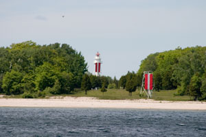
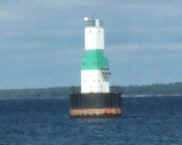
| 61.5 |
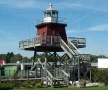
Washington Island Harbor (WI 23W)
June 10, 2006
We finished up our Michigan Cruise with a stop at Washington Island (had 12 passengers that needed a pick up). As we pulled into harbor, Ken Wardius (co-author of The Lighthouses of Wisconsin) commented that the light shown on the left is not in many directories of lights, and it should be. GLLKA
While it looks like a simple channel marker, you will note that it does have a solar operated light on the top, it is a fixed installation (not a buoy) and it has a classic "day mark" which also serves as the channel mark. On the other hand, if it is a light, it probably qualifies for "one of the ugliest". |
|
| 62 |
| Pottawatomie (WI 24)
access: ferry + walk (2 miles)
The island is accessible from late May to October by passenger ferry from Washington Island which is accessible by ferry from Northport. Given that there is a 2 mile walk to the lighthouse, this is not a small effort to get from Northport to the lighthouse and back the same day. ARLHS # USA-664
Photo courtesy sweet mustache [Flickr] |
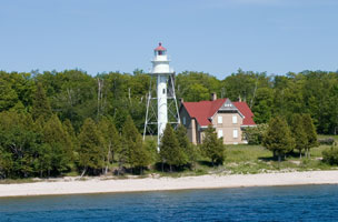
| 63 |
St. Martin (MI 112)
latitude 45° 30' 14.5" N longitude 86° 45' 31.5" W
access: boat
The light station is managed by the Little Traverse Bay band of the Odawa Indian Nation. Located on an island in the Rock Island Passage entrance to Green Bay, about 12 miles southwest of Fairport. Site and tower closed.
Photo courtesy Terry Pepper (2006) |
|
|
|
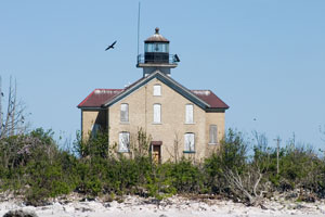
| 64 |
| Poverty Island (MI 113)
access: boat
This fine brick lighthouse, a sibling of the Sturgeon Point Light, deserves much better attention. Located on an island about 8 miles south of Fairport
Photo courtesy Terry Pepper (1996) |
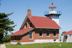
| 65 |
Eagle Bluff (WI 21)
latitude 45° 10' 7.1" N longitude 87° 14' 11.6" W
June 11, 2004
This is as far north as you can get in Door County without using a ferry. It's located in a very nice State Park (called Peninsula Park), so requires the $3 access fee (which is good for one hour for out of state people) As built, it featured a 3 1/2 Fresnel lens, but now is a solar powered light. ARLHS # USA-252 |
|
| 65.3 |
| Green Island (ruins and new skeleton) (WI 19)
latitude 45° 3' 18.3" N longitude 87° 29' 34.4" W
June 10, 2006 access: boat
The main light on Green Island was abandoned and a new light (see below) was constructed.
A combination of neglect, vandalism, and storms created this result. ARLHS # USA-945 |
| 65.4 |
Green Island (new) (WI 19K)
latitude 45° 3' 15.7" N longitude 87° 29' 30.5" W
access: boat
This is the current light on Green Island. It's just to the east of the ruins shown above. Probably very efficient, but no were near as interesting to look at. |
|
| 66 |
| Chambers Island (WI 20)
June 10, 2006 access: boat
This light is on the west end of Chambers Island and is now a private residence. The light has been removed and put in a museum (in NEBRASKA!). The column to the right is now the authentic light. There's no way to get here except by boat. ARLHS # USA-150 |
| 67 |
Sherwood Point (WI 18)
latitude 44° 53' 33.8" N longitude 87° 26' 0.9" W
June 10, 2006 access: car
The light is fully automated. During the summer, it's used as a residence for vacationing Coast Guard Personnel, so access may be difficult. It's on the western edge of the Sturgeon Bay Ship Canal.
To get here, exit 57 on County road PD, take a left (west) on County Road C, then go north on County Road M. In about 3 miles, take a left on E. Sherwood Pt. Rd. ARLHS # USA-754 |
|
| 68 |
| Peshtigo Reef (WI 17)
June 10, 2006 access: boat
This location marks a long reef that runs across (east-west) Lake Michigan. It originally was a lightship, but when they learned how to pour concrete in water, this quickly was made into a crib light. Hard to get to, we were part of a GLLKA tour of Lake Michigan. lightship
Note the brown streak in the water - that's how high the reef is. If you don't pay attention, this is major problem for most any boat. ARLHS # USA-951 |
| 69 |
Green Bay Harbor Entrance (WI 16) |
The only real options are to charter a boat or a plane. ARLHS # USA-352 |
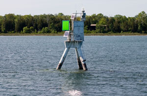
| 69.1 |
Kimberly (Neenah) (WI 12)
latitude 44° 11' 8.2" N longitude 88° 26' 30.1" W
access: car
From Highway 41 west of Neenah, take Exit 131 and follow Highway 114 east into the city. After 1.6 miles, turn right onto E. Wisconsin Avenue. After 0.9 miles, where Wisconsin Avenue ends at the lake, turn left on Lakeshore Avenue, which will lead to the park and the lighthouse.
Note that this light, and the next 3, are actually on Lake Winnebago, not Michigan ARLHS # USA-1070
Photo courtesy courtesy Michael Barlow [Webshots] |
|
| 69.2 |
| Asylum Point (WI 12A)
latitude 44° 3' 44.8" N longitude 88° 30' 52.8" W
access: car
This light was built by the WPA, but never activated. In 2007 it was restored. Go north from Oshkosh, enter Asylum Point park at Snell and Sherman Roads.
Photo courtesy Michael Barlow [Webshots] |
| 69.3 |
Bray's Point (WI 13)
access: car
From Highway 45 in Oshkosh north of the Fox River, take Irving Avenue east for 0.6 miles to Broad Street. Turn right onto Broad Street and follow it for 0.9 miles to Bay Shore Drive. Turn left onto Bay Shore and continue for 0.8 miles to Lake Street. The lighthouse can be seen from the street at the corner of Lake Street and Bay Shore Drive ARLHS # USA-1255
Photo courtesy Michael Barlow [Webshots] |
|
| 69.4 |
| Fond Du Lac (WI 14)
latitude 43° 47' 51.5" N longitude 88° 26' 14.1" W
access: car
At the junction of Highways 45 and 151 in Fond du Lac, turn north on Main Street and continue into Lakeside Park. When the road tees, turn right on Promen Drive and follow it to Park Drive. ARLHS # USA-725
Photo courtesy Michael Barlow [Webshots] |
| 69.5 |
Columbia Park (Pipe) (WI 15)
latitude 43° 54' 54.6" N longitude 88° 19' 57.4" W
access: car
Originally built as a water tower for the Fond du Lac Table Factory. It was moved in 1936 to the Calumet Harbor. Restored in 1992, it is located in Columbia Park on the eastern shore of Lake Winnebago.
Photo courtesy Michael Barlow [Webshots] |
|
| 70 |
| Grassy Island Range (a pair) (WI 11)
June 9, 2006
These lights were the a range system on Grassy Island until 1966 when they were removed for a dredging project. They are now located at the Green Bay Yacht club and pleasantly mark the channel entrance. |
| 71 |
Long Tail Point (ruins) (WI 10) |
Located on Long Tail Point which projects into the western side of Green Bay roughly four miles from the city of Green Bay. The lighthouse is in the Long Tail Point National Wildlife Refuge. ARLHS # USA-452 |
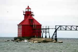
| 72 |
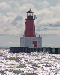
Menominee N. Pierhead (MI 48)
latitude 45° 5' 48.4" N longitude 87° 35' 11.4" W
June 9, 2006 access: car
Yet one more cast iron, bright fire engine red lighthouse at the end of a pier. The weather this day was bright and clear, but with a strong wind and only about 54°. With the wind coming in, the pier is pretty wet, so these photos are taken with the long lens rather than walking out and getting very wet. ARLHS # USA-490 |
|
| 72.1 |
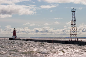
| Menominee N. Pierhead Rear Range (MI 48R)
latitude 45° 5' 45" N longitude 87° 35' 23.9" W
access: car
In fact, this is a very unusual front and rear range combination. Usually this is done on a ground basis, but as you can see here, it can also be done on a pier. |
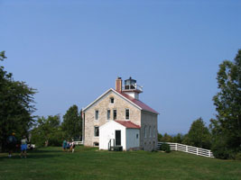
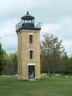
| 73 |
Sand Point (Escanaba) (MI 46)
latitude 45° 44' 36.6" N longitude 87° 2' 16.8" W
June 8, 2006 access: car
Note that this lighthouse is built facing backwards - the light faces the town, not the water. Maybe from 8 miles out it doesn't make any real difference, but all the other engineers seem to think it did. ARLHS # USA-275 |
|
| 73.5 |
| Escanaba Harbor (MI 47)
latitude 45° 44' 47.7" N longitude 87° 2' 14.9" W
September 29, 2000 access: car + long lens
This light isn't even listed in the book, but it's in the middle of the Escanaba channel. Maybe the book thinks it's only a buoy. ARLHS # USA-275 |
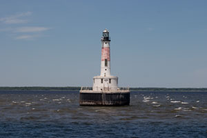
| 74 |
Minneapolis Shoal (MI 45) |
Located 9.6 miles south of Peninsula Point, marking the entrance to Little Bay De Noc. This lighthouse is best seen from the water or air. The distant shot is from the southern tip of Peninsula Point. One can charter a plane with Orion Flight Services out of the airport near Sturgeon Bay. Orion Flight Services ARLHS # USA-500 |
| 75 |
Peninsula Point (MI 44)
latitude 45° 40' 5.9" N longitude 86° 58' 1.2" W
September 29, 2000 access: car
The bulk of the lighthouse burned down in 1959, and only the tower remains. Physically, this is directly east of Escanaba, but nearly an hours drive (at the end of county 513) if you can't fly. ARLHS # USA-591 |
|
|
|
If you would like copies of any of my pictures, contact me and we'll discuss arrangements. There are others who do this commercially, I have no intention of competing directly, but you can make a proposal, and I'll react. MailMe
 Northern Lake Michigan
