|
This portion of Lake Michigan serves as the home page for the Lake showing the southern edge (but then for a significant part of the surrounding population, that is the entire lake). Downloadable pictures are available Flickr The lights of Lake Michigan are numbered clockwise from the very North (see that page) down the western shore, through Chicago and up the Eastern Shore. Note the links above to the rest of the pages. Note also a link to a Google Map (interactive, and you can see the ground if you choose (and they have the pictures at the necessary resolution)). The pictures below are live, if you click on one it will take you to a webshots photo of that same light. Index Numbers are taken from Great Lakes Lighthouses, American and Canadian p1 |
|
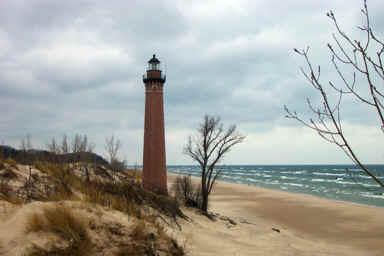
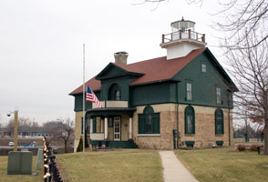
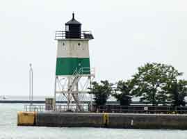
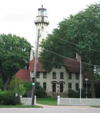
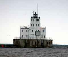
| 24 |
Little Sable (MI 59)
December 1, 2001 access: car
Located on the Sand Dunes of Lake Michigan, this has to be about as desolate as you can get.
If you're trying to get there, go to the Silver Lake State Park, then follow the signs to the lighthouse. Pay your parking fee and climb over the dunes. (If this picture looks cold, you understand well.) ARLHS # USA-443 |
|
| 25 |
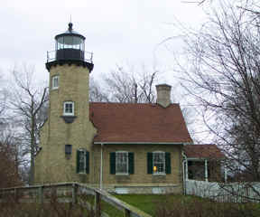
| White River (MI 58)
latitude 43° 22' 27.5" N longitude 86° 25' 30" W
December 1, 2001 access: car
Located at the mouth of White River (which is important because White Lake is about 100 feet from Lake Michigan, and makes a really slick harbor for small boats.)
It was inactive when we visited, but has a museum open during the "tourist" season. ARLHS # USA-885 |
| 26 |
Muskegon S. Pierhead (MI 56)
latitude 43° 13' 35.9" N longitude 86° 20' 29.3" W
July 15, 2006 access: car + walk
It looks like you can't really get to the light because there is a fully occupied Coast Guard Station at the base of the pier. However, you can cut through the AOP research center just west of the coast guard and walk right out the pier. Note how from the pier, you also can see the light below directly lined up. ARLHS # USA-1082 |
|
| 26.3 |
| Muskegon S. Breakwater (MI 57)
latitude 43° 13' 26.8" N longitude 86° 20' 49.2" W
July 15, 2006 access: car + long lens
Well off the pier there's a breakwater (which the adventurous can walk out on, but we didn't, so this photo is taken the long lens). On the tip of the breakwater is another light, which may or not intentionally, but in reality, is a range light with the light shown above. It's about the same size, but clearly much newer. ARLHS # USA-518 |
| 26.6 |
Muskegon N. Breakwater (MI 56A)
latitude 43° 13' 31.7" N longitude 86° 20' 53.6" W
July 15, 2006 access: car
And on the other side of the opening in the breakwater is another light. This one is the simple "drain pipe" design. |
|
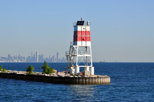
| 27 |
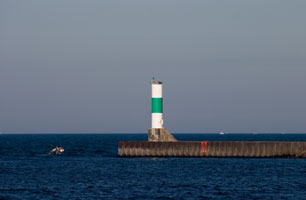
| Grand Haven S. Pierhead Entrance (MI 54)
latitude 43° 3' 24.1" N longitude 86° 15' 21.6" W
March 29, 2002 access: car
This is another pair of lights with an outer range light and an inner range light. In this case, they are even of different construction materials with grossly different appearance.
(I'm assuming you can see both of them through the fog!) ARLHS # USA-1078 |
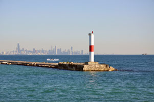
| 27.3 |
Grand Haven S. Pierhead Inner (MI 55)
latitude 43° 3' 26.2" N longitude 86° 15' 1.8" W |
ARLHS # USA-1077 |
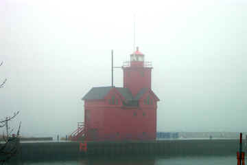
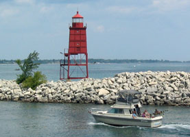
| 28 |
Holland Harbor S. Pierhead (MI 53)
latitude 42° 46' 19.9" N longitude 86° 12' 39.2" W
March 29, 2002 access: car
The attached building was built to run the fog horn. As you can see, they should have been running it the day we saw the lighthouse. ARLHS # USA-375 |
|
| 29 |
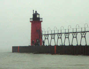
| South Haven S. Pierhead (MI 51)
latitude 42° 24' 5" N longitude 86° 17' 16.8" W
March 29, 2002 access: car
The cast iron lighthouse is connected by both a pier and an upper walkway. The upper walkway no longer has any plates on it, so it would be hard to use. As you can see, the waves today don't require it anyway. ARLHS # USA-772 |
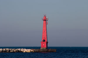
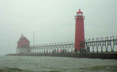
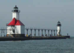
| 30 |
St. Joseph N. Pier Inner (MI 49)
latitude 42° 6' 57.9" N longitude 86° 29' 36.9" W
September 30, 2000 access: car
Note that there are actually 2 lights set on a pier to provide a "front range" "rear range" combination. This is the "inner" light. Note also the catwalk provided so that even when the pier is awash, the Coast Guard can get to the light (not that I'd want to walk out there in that kind of weather). ARLHS # USA-797 |
|
|
|
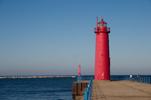
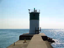
| 30.5 |
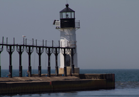
| St. Joseph N. Pierhead (MI 50)
latitude 42° 6' 58.9" N longitude 86° 29' 41.1" W
May 15, 2012 access: car
The front range light in St. Joseph ARLHS # USA-798 |
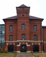
| 31 |
St. Joseph Lighthouse Depot (MI 49A)
latitude 42° 6' 50.6" N longitude 86° 29' 3.9" W
March 29, 2002
As you can see, this is not a lighthouse, in fact, at the time we recorded this photo, it was a lighthouse restaurant/microbrewery that was for sale. It was a supply, storage, replenishment depot for the lighthouse service until 1917. |
|
| 31.5 |
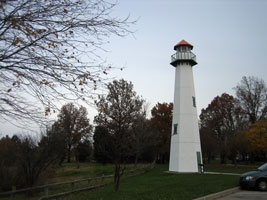
| I-94 Welcome Center (MI 49W)
latitude 41° 45' 54.3" N longitude 86° 44' 29.7" W
November 17, 2007 access: car
Clearly a faux light as there's no navigable water for miles. The sign next to it says "In Michigan, we'll leave a lighthouse on for you." |
| 32 |
Michigan City Old Light (IN 4)
latitude 41° 43' 21.8" N longitude 86° 54' 21.8" W
December 30, 2006 access: car
This is actually the second lighthouse in Michigan City (the third is below.) It is set well off the water way (more than 1000' I would estimate). It is now an active museum. ARLHS # USA-913 |
|
| 33 |

| Michigan City Breakwater (IN 5)
latitude 41° 43' 44.4" N longitude 86° 54' 42.1" W
December 30, 2006 access: car
It looks like they have done double duty with the front light. It marks the far side of the channel for boats that are in close. It provides a front range light for boats well out in the lake. ARLHS # USA-493 |
| 33.1 |
Michigan City Outer Breakwater (IN 6)
latitude 41° 43' 47.3" N longitude 86° 54' 50" W |
ARLHS # USA-1016 |
| 33.3 |
Burns Waterway East Jetty Lights (IN 7) |
These lights can be seen from the Coastal Park, but there is no trail to get you from Highway 12 to them, so the getting over the dunes is tough going.
There appears to be a public harbor in Burns that could be used to put a boat into the water if you wish to see this light and the lights below. |
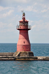
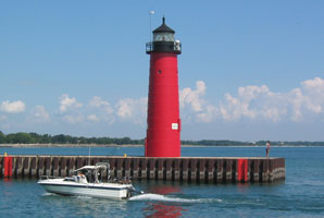
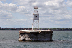
| 33.6 |
Gary Breakwater (IN 3)
latitude 41° 37' 49.4" N longitude 87° 19' 13.2" W
December 30, 2006 access: boat
Turn north on Lake Street in Miller IN and cut through the Coastal Park to Marquette Park. You can then walk across the shore to see this spot ARLHS # USA-317
Photo courtesy Terry Pepper |
|
|
|
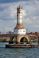
| 34 |
Gary Harbor Bulkhead (IN 3A) |
As the area surrounding the pier is industrial and private, the Gary Harbor Breakwater Lighthouse is best seen from the water. |
| 35 |
Buffington Breakwater (IN 2)
latitude 41° 38' 45.7" N longitude 87° 24' 37.1" W
December 30, 2006 access: car
We took a tour through this area and were able to get close to only 2 lights. This photo was taken from the shoreline behind the Majestic Star Casino. The weather was ugly, so it has been significantly digitally enhanced. ARLHS # USA-1017 |

|
| 36 |
| Indiana Harbor E. Breakwater (IN 1)
latitude 41° 40' 51" N longitude 87° 26' 27.8" W
access: boat
Due to the private, industrial area surrounding the breakwater, the Indiana Harbor Lighthouse is best seen from the water. One can visit this light with Coho Magic Charters out of Robert A. Pastrick Marina in East Chicago, IN. ARLHS # USA-402
Photo courtesy Terry Pepper |
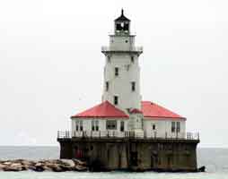
| 37 |
Chicago Harbor (IL 3)
latitude 41° 53' 21.6" N longitude 87° 35' 26" W
June 12, 2004
This is an active Coast Guard Installation and no public access is allowed. The light was built in 1893, but moved to this location in 1917. (Our tour boat said it was built in Seattle, and moved here for the 1933 World's Fair, but I believe the other account better.) You can see it from the Navy pier, but the harbor tours go even closer ARLHS # USA-170 |
|
| 38 |
| Chicago Harbor SE Guide Wall (IL 4)
latitude 41° 53' 23.5" N longitude 87° 35' 59" W
June 12, 2004 access: car
Built in 1938, this light is right next to the Navy Pier. ARLHS # USA-930 |
| 38.3 |
Calumet Harbor (IL 5)
access: boat
This lighthouse can be seen distantly from Calumet Park, but is best seen from the water. To reach the park, take Exit 62 from I-94 South of Chicago and go east for five miles on 95th Street (Highway 12/20) to the park. ARLHS # USA-102
Photo courtesy Terry Pepper |
|
| 38.6 |
| Calumet Harbor Breakwater (IL 6)
access: boat
demolished in 1995 Clearly rebuilt somewhat later as a "sewer pipe" fixture. ARLHS # USA-1190
Photo courtesy Terry Pepper |
| 38.7 |
Hope Light (faux) (IL 7)
latitude 37° 8' 39.4" N longitude 88° 43' 43.8" W
access: car
The World's first lighthouse dedicated to the fight against Cancer
Metropolis Illinois at the entrance to the Dorothy Miller Park on the Ohio River
Photo courtesy mark71 [maps.google.com] |
|
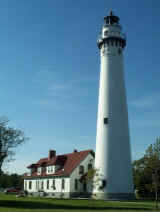
| 39 |
| Grosse Point (IL 2)
latitude 42° 3' 50" N longitude 87° 40' 33.6" W
August 2, 2003 access: car
Built in 1873, this lighthouse has a very impressive "keepers" house at the end of a street filled with impressive faculty houses (from Northwestern people one assumes). It now is an active museum with the original 2nd order Fresnel lens still in place an operated by the city of Evanston. ARLHS # USA-359 |
| 40 |
Waukegan Harbor (IL 1)
latitude 42° 21' 38.4" N longitude 87° 48' 48.2" W
August 2, 2003 access: car
This might have been more interesting when the original lantern room was present, but I suspect not. As you can see, it now has an automated light on top of the original base. Its at the end of a pier that's about 30 miles long (well, ... maybe about ½ mile) directly out from the Waukegan Yacht club. ARLHS # USA-875 |
|
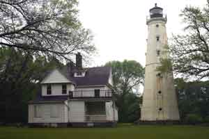
| 41 |
| Southport Kenosha (old) (WI 45)
latitude 42° 35' 22" N longitude 87° 48' 56.5" W
August 2, 2003 access: car
At the time this lighthouse was built in 1866, this place was known as Southport. It was the first light a boat from Chicago would see in Wisconsin and was originally equipped with a 4th order Fresnel lens (which if you remember, is not really a lens, but a whole cluster of prisms that act like a single lens) ARLHS # USA-912 |
| 42 |
Kenosha N. Pierhead (WI 44)
latitude 42° 35' 19.8" N longitude 87° 48' 31" W
August 2, 2003 access: car
Just like the picture below, you can't really get to this lighthouse but you can get to a point right across the channel. ARLHS # USA-416 |
|
| 43 |
| Racine N. Breakwater (WI 43)
latitude 42° 44' 4.7" N longitude 87° 46' 19.3" W
August 2, 2003 access: car
You really can't see this from the breakwater, but there's a really slick parking spot just across the channel, and then this boat nicely came in to improve the picture. ARLHS # USA-682 |
| 43.5 |
Old Racine Harbor Light (Racine Reef) (WI 43B)
access: car + walk
At this point, this is a skeletal tower on top of a crib.
From I-94, take Hwy 20 east. Hwy 20 eventually becomes Washington Ave. Follow Washington Ave. to Hwy 32, and head north on Hwy 32. Turn right on Christopher Columbus Causeway, and follow around the marina until the road ends in a parking area. Walk the short distance to the lighthouse at the marina entrance. ARLHS # USA-683
Photo courtesy Terry Pepper |
|
| 44 |
| Wind Point (WI 42)
latitude 42° 46' 52.7" N longitude 87° 45' 32.4" W
August 2, 2003 access: car
Another of the classic "Poe" style lights, it is similar to Grosse Point. Interestingly enough, it now serves as the village hall and police department. ARLHS # USA-894 |
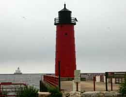
| 45 |
Milwaukee Pierhead (WI 40)
latitude 43° 1' 33.4" N longitude 87° 53' 43.4" W
June 11, 2004 access: car
Its very hard to get to this light, they've buried it behind a very nice stage and are burying it next to some very nice condos. But, once you get here, there's good parking and a nice view. In the distance, you can see the light shown below. ARLHS # USA-498 |
|
| 46 |
| Milwaukee Breakwater (WI 41)
latitude 43° 1' 37.2" N longitude 87° 52' 55.3" W
June 11, 2004 access: car + long lens
Theoretically only accessible by boat, but, if the weather's fine, and you have a long lens, you can see this from the pierhead shown above. (On our previous visit, you could not see across the harbor, so it's not that close, but close enough.) ARLHS # USA-497 |
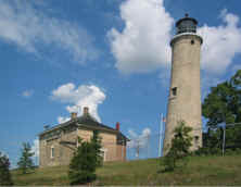
| 47 |
North Point (WI 39)
latitude 43° 3' 56.1" N longitude 87° 52' 17" W
June 11, 2004 access: car
This is another light that's hard to find. Our directions said only "go north from Milwaukee 3 miles". The second time around, we found it easier, but ... Note carefully the break about 1/2 way up the light. First built 30' tall, the trees got too big. So rather than cut the trees, they put another 35' underneath the tower. This light house is in Lake Park, to the right of the bowling (lawn bowling) greens. ARLHS # USA-556 |
|
|
|
If you would like copies of any of my pictures, contact me and we'll discuss arrangements. There are others who do this commercially, I have no intention of competing directly, but you can make a proposal, and I'll react. mailto
 Western Lake Michigan