|
Here's the top of Lake Michigan. These pictures start at the Michigan/Wisconsin border and rotate clockwise to the east. These photos are available in a Flickr album, and each one is live, so that if you click on it, you'll be taken to a larger photo of that same light. Album Index Numbers are from Great Lakes Lighthouses, American and Canadian p1 |
|
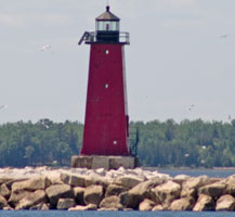
| 76 |
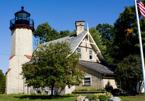
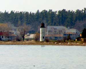
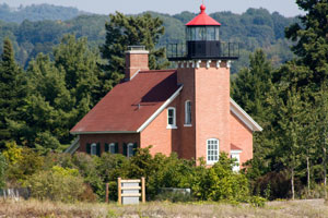
Manistique E. Breakwater (MI 43)
latitude 45° 56' 42" N longitude 86° 14' 47.7" W
June 8, 2006 access: car
This steel plate constructed lighthouse is painted fire engine red to provide safe passage. explore
It stands 35 feet high and was commissioned in 1915 (from the description plate at the end of the pier) ARLHS # USA-469 |
|
| 77 |
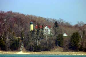
| Seul Choix Point (MI 42)
latitude 45° 55' 17.8" N longitude 85° 54' 41.8" W
June 8, 2006 access: car
French for "only choice" (but not pronounced like it's French), this light declares about the only safe harbor on the northern shore of Lake Michigan. *
It contains a full museum and gift shop as well. ARLHS # USA-749 |
| 79 |
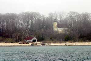
| St. Helena Island (MI 39)
latitude 45° 51' 18" N longitude 84° 51' 52.2" W
September 9, 2009 access: boat
Now owned by the Great Lake Lighthouse Keepers Association (GLLKA), this is accessible only by boat.The GLLKA has been renovating this place, they have a picture of two of them bringing an organ (pump style) in on a rubber boat. The organ is twice the size of the boat. sheplers ARLHS # USA-794 |
| 78.5 |
Naubinway Island (MI 39N)
latitude 46° 4' 31.5" N longitude 85° 26' 42.7" W |
A classic D9 light just south of the village of Naubinway |
| 1 |
McGulpin Point (MI 79)
latitude 45° 47' 13.1" N longitude 84° 46' 21.8" W
September 3, 2006 access: car
Now owned by Emiott County and is relit. This light was established in 1869 and deactivated in 1906 when the Mackinaw Point Light was established. MI 80 ARLHS # USA-487 |
|
| 2 |
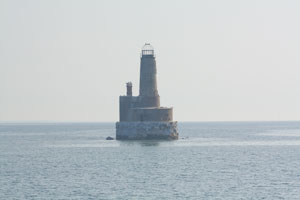
| Waugoshance (MI 78)
latitude 45° 47' 11.1" N longitude 85° 5' 50.7" W
September 9, 2009 access: boat
This lighthouse is really nothing but ruins, was even used by the Navy during WW II as a bomb practice site. It was established in 1851 and was deactivated in 1910. The water here is really shallow, so getting a boat close is tough, and it's miles from the shore. seeing ARLHS # USA-874 |
| 2.5 |
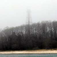
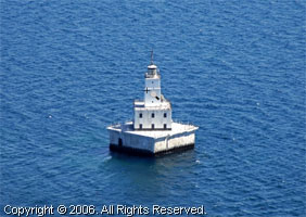
Grays Reef (MI 77G) |
Built in 1936, the only access is by boat |
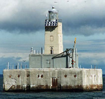
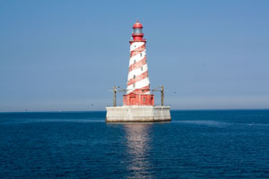
| 3 |
White Shoal (MI 77)
latitude 45° 50' 32.4" N longitude 85° 8' 13.1" W
September 9, 2009 access: boat
The only "barber pole" (or "candy cane") lighthouse on the Great Lakes, this is still an active lighthouse. Established in 1910, it has been automated since 1976. The tower is 121 feet high, but the base (under water) is actually taller. ARLHS # USA-886 |
|
|
|
| 5 |
| Squaw Island (MI 41)
latitude 45° 50' 21.5" N longitude 85° 35' 16.8" W
May 7, 2005 access: boat
This picture is from a GLLKA tour that Marnie and I took the Saturday before Mother's day. The morning was foggy, the entire day was cold, but we had a fun tour. This picture is taken with "the long lens",; and then digitally zoomed to get me close enough that you can see it The water is very shallow, and this was as close as we could get the boat. gllka
Building started in 1892 and the light was lit October 10, 1892. The light was deemed obsolete in 1928. Private owners are responsible for most of the renovations to date. ARLHS # USA-786 |
| 6 |
Beaver Island Harbor (St. James) (MI 74)
latitude 45° 44' 33" N longitude 85° 30' 31.7" W
May 7, 2005 access: boat
This harbor was originally established for emergency use in a nasty storm. Thus the lighthouse was a natural. Currently, this is the harbor that is used by the Beaver Island ferry, so the light is still active for navigation. ARLHS # USA-047 |
|
| 7 |
| Beaver Island (Beaver Head) (MI 73)
latitude 45° 34' 38.3" N longitude 85° 34' 34.7" W
May 7, 2005 access: boat or ferry
You can see this light by taking the Beaver Island Ferry (which accepts your car) and driving to it. We took this picture from a GLLKA tour (which happened to have chartered the Beaver Island Ferry boat as it's method of transportation). history
Built in 1852, then the tower was rebuilt in 1858. It was decommissioned in 1962 and currently is an environmental education center. ARLHS # USA-046 |
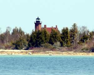
| 8 |
Ile Aux Galets (Skillagalee) (MI 75)
latitude 45° 40' 31.2" N longitude 85° 11' 4.2" W
September 9, 2009 access: boat
This was one of the earliest lights on the Great Lakes. This picture taken from the GLLKA "Ultimate Lighthouse Tour." nMichigan ARLHS # USA-399 |
|
| 9 |
| South Fox Island (2 lights) (MI 72)
latitude 45° 22' 40.8" N longitude 85° 50' 19.2" W
May 7, 2005 access: boat
This light (and below) are abandoned, but as you can see, in good condition. *
Built in 1867 and the light was first lit November 1, 1867. The white paint over the yellow brick was first put on in 1910. ARLHS # USA-771 |
| 9.3 |
South Fox Island (new) (MI 72A)
access: boat
This structure was imported from Darien Georgia in 1934 after the light above was shut down. However, at this time, it also is shut down. This new light is on the left corner of the island, as you are facing the light shown above. lhdepot
(If the weather looks poor, then you begin to understand the situation. This light was basically invisible. Only digital image correction allows you to see it.) |
|
| 10 |
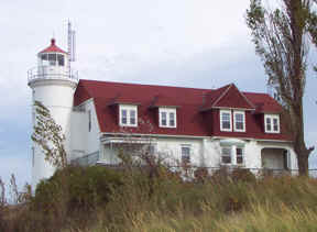
| Little Traverse (Harbor Point) (MI 71)
latitude 45° 25' 7.7" N longitude 84° 58' 41.5" W
September 9, 2009 access: boat
Take US-31 to downtown Petoskey, and turn off at the entrance to the municipal marina, where there are plenty of parking spaces. If you do not have your own boat, the only way to obtain offshore views of the station will be by hiring a charter fishing boat to take you out to the Point.
Note that it is impossible to gain access to the station from the land, as there is only one road leading out to the Point, and it passes right through the guarded entrance to the gated community of Harbor Springs. ARLHS # USA-444 |
| 11 |
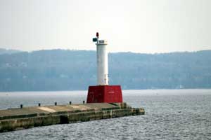
Petoskey West Pier Head (MI 70A)
latitude 45° 22' 48" N longitude 84° 57' 41.8" W
May 8, 2005 access: car
Nothing very fancy, just "a sewer pipe on a base". Terminology not original, and not mine ARLHS # USA-1085 |
|
|
|
| 12 |
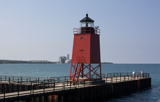
| Charlevoix S. Pierhead (MI 70)
latitude 45° 19' 14.9" N longitude 85° 15' 53.3" W
September 9, 2009 access: car
Over the years, this light has been green (on the right pier), red (on the left pier) and white (who knows why.) It is now red again. ARLHS # USA-156 |
| 13 |
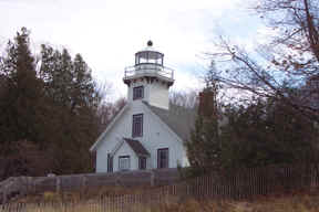
Old Mission Point (MI 69)
latitude 44° 59' 28" N longitude 85° 28' 46.6" W
November 9, 2001 access: car
This was a private residence, but is now open. M-37 runs right up the peninsula from Traverse City ending at the lighthouse parking lot. Volunteer keeper reservations are being accepted for 2009. ARLHS # USA-504 |
|
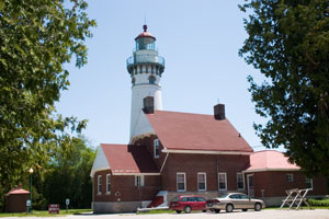
| 14 |
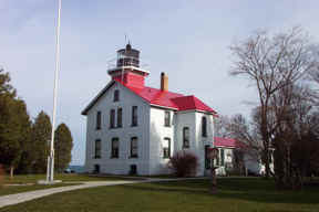
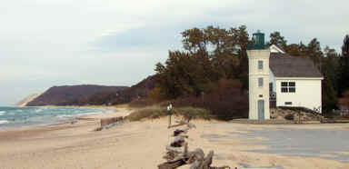
| Grand Traverse (MI 68)
November 9, 2001 access: car
This is a museum May to October (so I didn't see it today). Looks very interesting and worth the :30 drive up from Traverse City seeing ARLHS # USA-332 |
| 15 |
North Manitou Shoal (MI 67)
access: boat or ferry
This light is best seen from a boat. Manitou Island Transit offers ferry service and day trips to South Manitou Island from Leland, and a distant view of North Manitou Shoal Light is possible from the ferry. ferry ARLHS # USA-554 |
|
| 16 |
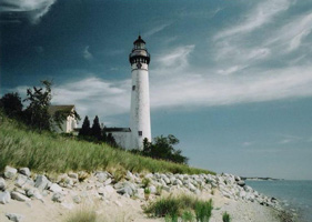
| South Manitou Island (MI 66)
latitude 45° 27.9" N longitude 86° 5' 36.6" W
access: boat
The South Manitou Island Lighthouse is the most familiar landmark on the island and is clearly visible from the mainland. The 100 foot lighthouse tower, active from 1871 to 1958, marked the location of the only natural harbor between here and Chicago. ARLHS # USA-773
Photo courtesy Geoffrey George [wikipedia] |
| 17 |
Manning Memorial (MI 65B)
January 12, 2007 access: car
Built to honor a long time resident of Empire, this is still a beautiful location even if not a real aid to navigation. ARLHS # USA-1268 |
|
| 18 |
| Point Betsie (MI 65)
October 18, 2001 access: car
This is now the residence for Coast Guard personnel, but you get a good view from the beach anyway. ARLHS # USA-616 |
| 19 |
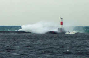
Frankfort N. Breakwater (MI 64)
latitude 44° 37' 50.2" N longitude 86° 15' 7.9" W
October 18, 2001 access: car
As you can see, the wind was blowing pretty hard on the lake, so this picture was taken with the telephoto lens instead of getting close to the lighthouse. ARLHS # USA-308 |
|
| 19.3 |
| Frankfort S. Breakwater (MI 64A)
October 18, 2001 access: car
While only a "sewer pipe" lighthouse, the water breaking over the breakwater makes a really neat sight. ARLHS # USA-1075 |
| 20 |
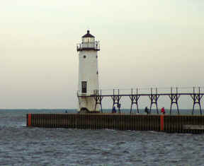
Manistee N. Pierhead (MI 63)
latitude 44° 15' 7.5" N longitude 86° 20' 46.9" W
October 18, 2001 access: car
A simple light at the end of the breakwater, nothing fancy, but workable is the rule. wrensCottage ARLHS # USA-468 |
|
| 20.3 |
| Manistee S. Pierhead (MI 63S)
latitude 44° 15' 4" N longitude 86° 20' 58.6" W
October 18, 2001 access: car
Looks amazing like Frankfort doesn't it? |
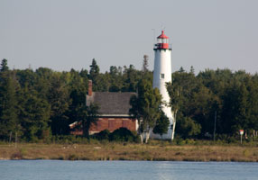
| 21 |
Old Manistee Main (MI 63O)
latitude 44° 15' 0.2" N longitude 86° 20' 20.4" W |
From US31, take Memorial Drive West approximately one mile to the Lake. Note that Memorial Drive changes to 5th Avenue along the way. ARLHS # USA-467 |
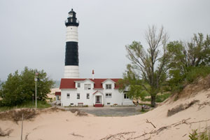
| 22 |
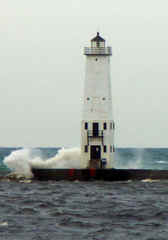
Big Sable Point (MI 62)
latitude 44° 3' 27.7" N longitude 86° 30' 52.2" W
July 14, 2006 access: car + walk (2 mile)
Built in 1867, this is a very impressive lighthouse, well isolated (2 mile walk from the nearest road). Note the large house managers home - this looks like it might even have been a duplex. ARLHS # USA-054 |
|
| 23 |
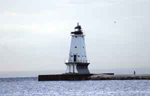
| Ludington N. Breakwater (MI 61)
latitude 43° 57' 13.3" N longitude 86° 28' 9" W
June 9, 2004 access: car
Like Manistee, this is a simple light showing the end of the breakwater. However, unlike Manistee, this one looks like it has a terminal case of the uglies.
(Such is life.) ARLHS # USA-460 |
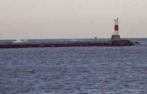
| 23.5 |
Pentwater N. Pierhead (MI 60)
latitude 43° 46' 56.2" N longitude 86° 26' 37.5" W |
From US 31, take Business 31 into Pentwater. Turn west on Lowell Street which will take you to Charles Mear State Park from where you can view the lights. State Park ARLHS # USA-594 |
| 23.6 |
Pentwater S. Pierhead (MI 60S)
latitude 43° 46' 54.9" N longitude 86° 26' 39.2" W |
A Historic Acetylene Tower erected in 1937 ARLHS # USA-594 |
|
|
If you would like copies of any of my pictures, contact me and we'll discuss arrangements. There are others who do this commercially, I have no intention of competing directly, but you can make a proposal, and I'll react. mail me

 Lake Superior