|
This page shows the Lighthouses of the New Hampshire and Vermont. Copies of these pictures are stored on the Webshots site if you want to download them. Each picture is also a direct link to a larger version of it on webshots. Just click on the picture and it will open in a new window. webshots Index numbers are from the Shanklin List of all US lights. p2 |
|
New Hampshire
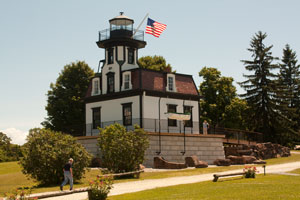
| NH 1 |
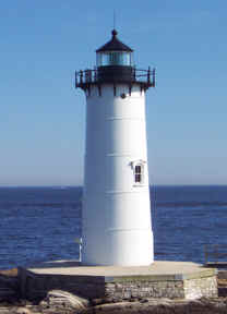
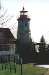
Portsmouth (NH) Light
latitude 43° 4' 15.8" N longitude 70° 42' 31.1" W
June 26, 2012
The original tower at Fort Point was built in 1771. This cast iron tower was built in 1877.
Take highway 1 to downtown Portsmouth, then Highway 1B south to Fort Point. Technically you are now in New Castle, NH (J 0234) |
|
| NH 1M |
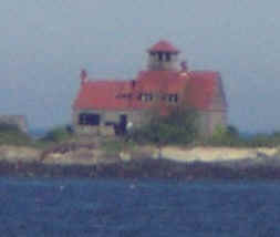
| Wood Island Lifesaving Station.
June 21, 2002
Photo taken from Fort Point. There's an adjacent light that is technically in Maine. (identified by placard as the Portsmouth Shoals) Maine |
| NH 2 |
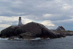
Isle of Shoals (White Island)
latitude 42° 58' 2" N longitude 70° 37' 24.2" W
The Isles of Shoals are a group of 18 islands and rocks 9 miles southeast of Portsmouth. The New Hampshire portion of the Isles comprise a state park. Accessible only by boat, cruises from Portsmouth pass the site.
(J 0246)
Photo courtesy Nancy [Wikipedia] |
|
| NH 3 |
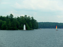
| Herrick Cove
latitude 43° 24' 40.1" N longitude 72° 2' 30.1" W
At the entrance to Herrick Cove, at the northern end of Lake Sunapee.
Photo courtesy mmwm [Flickr] |
|
|
| NH 4 |
Loon Island
near the entrance to Sunapee Harbor.
Photo courtesy Joseph Brophy |

|
| NH 5 |
| Burkehaven
latitude 43° 22' 18" N longitude 72° 3' 57.4" W
visible from tours of the lake offered by Sunapee Cruises cruises
The tours depart from Sunapee Harbor.
Photo courtesy mmwm [Flickr] |
Vermont
Many of you may disbelieve that Vermont has lighthouses. After all, it doesnt border on a Great Lake, or on the Ocean. But it does have lights on Lake Champlain. We havent visited them yet, but here are the references to them.
| VT 1 |
Windmill Point
latitude 44° 58' 55.1" N longitude 73° 20' 28" W
From Highway 9 just south of Rouses Point (NY), turn east onto Stony Point Road. Near the end of the road you will find a breakwater, which affords fair views of the lighthouse. ARLHS # USA-895
Photo courtesy stageliter [webshots] |
|
|
|
| VT 2 |
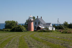
| Isle La Motte
latitude 44° 54' 23.5" N longitude 73° 20' 36.3" W
July 2, 2010
From Highway 2, which runs north/south along the islands of Lake Champlain, turn west on Highway 129 and follow it onto Isle La Motte. Turn right onto Shrine Road and then right onto Lighthouse Point Road. You will have to walk the last few hundred yards and cross a field to where you will see the light. ARLHS # USA-405 |
| VT 3 |
Juniper Island
latitude 44° 26' 59.5" N longitude 73° 16' 34.5" W
Located on Juniper Island, just over three miles offshore from Burlington. This lighthouse and island are privately owned. Only the very top of the tower is visible from the lake. ARLHS # USA-410
Photo courtesy juniper015 [webshots] |
|
| VT 4 |
| Colchester Reef
latitude 44° 22' 19.1" N longitude 73° 13' 53.6" W
July 2, 2010
(Moved to the Museum at Shelburne.) museum
To view the lighthouse, travel south from Burlington on Highway 7 for roughly seven miles to Shelburne. The Shelburne Museum is one mile south of the center of Shelburne on the west side of Route 7. The light is inside the museum and you must pay an entry fee to see it. ARLHS # USA-182 |
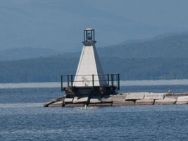
| VT 5 |
Burlington Breakwater North
latitude 44° 28' 49.4" N longitude 73° 13' 46.7" W
July 2, 2010
Take Main Street in downtown Burlington west until it ends near the waterfront. Turn right on Lake Street and follow it for 0.4 miles until you can cross over the railroad tracks. ARLHS # USA-094 |
|
| VT 6 |
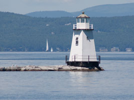
| Burlington Breakwater South
latitude 44° 28' 11.5" N longitude 73° 13' 31.8" W
July 2, 2010
The lighthouse can be viewed from the Main Wastewater Treatment Facility in Burlington. Follow Battery Street, which parallels the waterfront, south until it ends. Turn right onto Maple and then left onto Valley Lane that will lead to the treatment facility. ARLHS # USA-095 |
|
|
If you would like copies of any of my pictures, contact me and we'll discuss arrangements. There are others who do this commercially, I have no intention of competing directly, but you can make a proposal, and I'll react. mailMe
 Maine
Maine
 East New York

