|
This page currently shows my understanding of Lighthouses of Prince Edward Island. Copies of these pictures are stored on the web if you want to download them. Click on [most] any photo and that will take you to that photo. Orange italicized numbers in parentheses are reference numbers used by the Canadian Coast Guard List of Lights (Atlantic Lights) p4 |
|
| PE 0 |
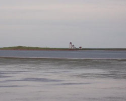
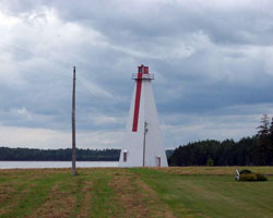
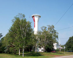
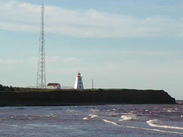
North Cape
latitude 47° 3' 27.6" N longitude 63° 59' 47.9" W
A long, rocky reef, purported to be the longest in North America, extends seaward from the northeast tip of Prince Edward Island for roughly 1.5 miles and marks the dividing point between the Gulf of St. Lawrence and Northumberland Strait.
Take Highway 2 to Tignish near the northwest tip of Prince Edward Island and then take Dalton Avenue towards the shore. When Dalton Avenue ends, turn left onto Route 12 and follow this road to the northern tip of the island, where you will find the North Cape Lighthouse just past the North Cape Interpretive Center. (1036) ARLHS # CAN-345
Photo courtesy djbjr [webshots] |
|
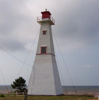
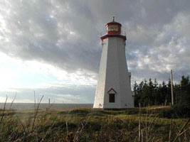
| PE 1 |
| Judes Point (Big Tignish)
latitude 46° 57' 3.6" N longitude 63° 59' 37.6" W
access: car
The lighthouse is on Judes Point Road in the village of Tignish Shore (1083) ARLHS # CAN-036
Photo courtesy djbjr [webshots] |
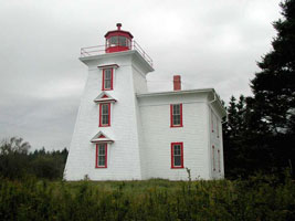
| PE 2 |
Northport Rear Range
The front range tower is skeletal.
Located at the entrance to Northport Harbour off PE 12 in Alberton. (1081) ARLHS # CAN-354
Photo courtesy Phil Maynard [webshots] |
|
| PE 3 |
Alberton |
On Sand dunes (1077) ARLHS # CAN-008 |
| PE 4 |
Cascumpec
There is no regular transportation to the island, but the lights can be seen from Northport Harbour. (1076) ARLHS # CAN-122
Photo courtesy Phil Maynard [webshots] |
|
| PE 5 |
Darnley Basin |
2 lights at center of bridge (1071.2) ARLHS # CAN-156 |
| PE 6 |
Malpeque Harbour Front Range
On Blue Heron Drive, Route 20, turn off at Darnley towards Profitts Point. This lighthouse is on private property among cottage lots near the shore. (1068) ARLHS # CAN-297
Photo courtesy sodoff104 [webshots] |
|
| PE 7 |
| Malpeque Harbour Rear Range
This light is best viewed from Cabot Beach Provincial Park. Follow Blue Heron Drive, Route 20 to Malpeque. From here follow the signs to the park. (1066) ARLHS # CAN -298
Photo courtesy noklugh [webshots] |
| PE 8 |
Malpeque Outer Range |
The main entrance to Malpeque Harbour (Richmond Bay) lies between Billhook (Fish) Island and Cape Aylesbury. To reach the entrance, mariners first follow the Darnley Point Range Lights (Malpeque Outer Range Lights), located just over a kilometer east of Cape Aylesbury, until this range line intersects that of the Fish Island Range Lights (Malpeque Harbour Approach Range Lights). This second pair of range lights then guides the mariner into the harbour.
From Kensington, take Route 20 north for 9.7 miles then turn left onto Lower Darnley Road. After 1.7 miles, turn right onto Lighthouse Road and you will see the Malpeque Outer Range Rear Lighthouse in a field on your left. Note that Lighthouse Road is private. cottages (1062) ARLHS # CAN-299 |
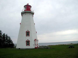
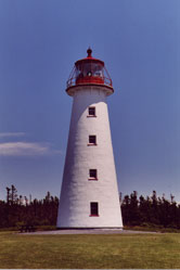
| PE 9 |
Cape Tryon
latitude 46° 32' 2.4" N longitude 63° 30' 21.6" W
No public access, and the rocks below the light are treacherous (1061) ARLHS # CAN-113
Photo courtesy Phil Maynard [webshots] |
|
| PE 10 |
New London Front Range |
A steel skeleton structure (1059) ARLHS # CAN-340 |
| PE 11 |
New London Rear Range
latitude 46° 30' 37.4" N longitude 63° 29' 13.2" W
The New London Lighthouse is in an interesting location, across the mouth of the harbour from one of the most popular, and beautiful, beaches in Canada at Cavendish.
From Highway 6 in New London at the Lucy Maud Montgomery Birthplace, go north on Highway 20 for 4.3 miles and then turn right on River Road (Route 263). Follow River Road until it ends, then turn right onto Cape Road and drive to its end where you can park your car and walk down a dirt road to the New London Range Rear Lighthouse. (1060) ARLHS # CAN-341
Photo courtesy tvordlj [webshots] |
|
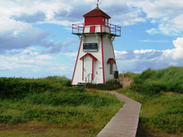
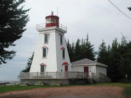
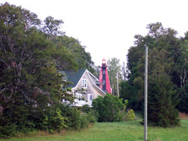
| PE 12 |
| North Rustico Harbour
latitude 46° 27' 19.1" N longitude 63° 17' 31.2" W
North Rustico, situated on the northern shore of Prince Edward Island facing the Gulf of St. Lawrence, was founded around 1790 by Acadians. Before the erection of the lighthouse, a pair of range lights had been used to guide mariners into the harbour at North Rustico. This light is at risk. Groups are attempting to save the light from the ravages of the Lighthouse Heritage Protection Act. preservation
From Route 6 in North Rustico, turn east on Harbourview Drive and follow it around the harbor for 1.1 miles to the North Rustico Lighthouse. (1056) ARLHS # CAN-350
Photo courtesy © M. Sigurdson [webshots] |
|
|
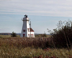
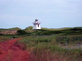
| PE 13 |
Covehead Harbour
From Stanhope on Highway #6, take Road #25. The lighthouse is right by the roadside about a mile away. (1051) ARLHS # CAN-151
Photo courtesy ERS99 [Flickr] |
|
| PE 14 |
| St. Peter's Harbour
Turn off the King's Byway (Route 2) between Bristol and Morell. Follow a lane going down to the shore to some cottages. If the road is dry, drive around the body of water to the end of the road and the turning area. Otherwise, enjoy the walk. (1045) ARLHS # CAN-479
Photo courtesy Phil Maynard [webshots] |
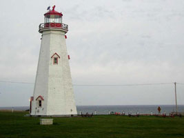
| PE 15 |
Shipwreck Point (Naufrage)
latitude 46° 28' 11.1" N longitude 62° 25' 15.8" W
Located off the King's Byway, Route 16 at Naufrage Harbour. Watch for a sign pointing to Shipwreck Point at Naufrage Harbour. The lighthouse is on private property but may be viewed from a distance. (1042) ARLHS # CAN-459
Photo courtesy Phil Maynard [webshots] |
|
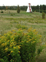
| PE 16 |
North Lake Harbour |
A pair of Range Lights (1039) ARLHS # CAN-346 |
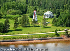
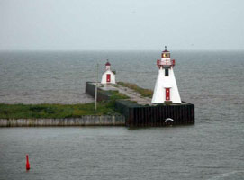
| PE 18 |
East Point
Turn off Route 16 (King's Byway) onto a road marked "East Point Light". From East Point Road, turn east on Lighthouse road and follow to the end. (943) ARLHS # CAN-165
Photo courtesy djbjr [webshots] |
|
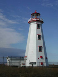
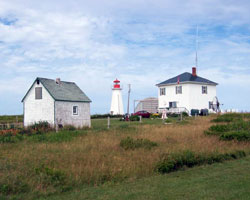
| PE 19 |
| Souris East (Knight Point)
This lighthouse can be seen from the ferry between Prince Edward Island and Quebec's Magdalene Islands. It can also be seen from any point on the waterfront. The lighthouse is fenced off but you can get fairly close to it. (947) ARLHS # CAN-465
Photo courtesy djbjr [webshots] |
| PE 20 |
Annandale Front Range (Banks Point)
From Route 310 on the King's Byway, look for the signs directing you to Annandale Harbour. (949) ARLHS # CAN-011
Photo courtesy Phil Maynard [webshots] |
|
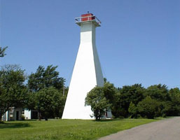
| PE 21 |
| Annandale Rear Range (Juniper Point)
This is the second-tallest lighthouse on the island. It stands nearly a mile northwest of the front range tower. Located off PE 310 on Juniper Point at Annandale Harbour (950) ARLHS # CAN-012
Photo courtesy Phil Maynard [webshots] |
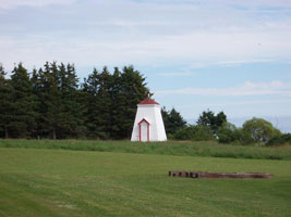
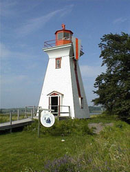
| PE 22 |
Panmure Island
Follow Rte.17 east, out of Montague, until you reach Rte.347, turn right and travel 2 Km. to reach this jewel of a island. (953) ARLHS # CAN-363
Photo courtesy djbjr [webshots] |
|
| PE 23 |
Georgetown Front Range 1969 |
Located at Lower Montague, near Georgetown.
From Route 17, 2.6 miles east of Montague, turn north onto Lower Montague Road. When you reach the shore, go right on St. Andrews Point Road for 1.8 miles and you will see the Lighthouse on your left. (955) ARLHS # CAN-195 |
| PE 24 |
Georgetown Front Range (old) (St. Andrews Point) |
After deactivation, the lighthouse was relocated as a private residence. It has been altered somewhat from its original appearance. (1868) ARLHS # CAN-195 |
|
|
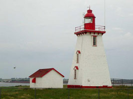
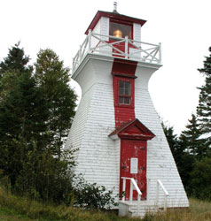
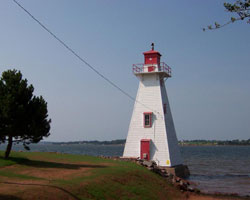
| PE 26 |
| Cape Bear
Follow Route 18, the King's Byway, to Cape Bear and the museum. To reach the lighthouse: at a sharp bend in the paved road, turn off onto a dirt road, then go down the second lane on the right. You'll find the lighthouse in the woods. (971) ARLHS # CAN-092
Photo courtesy djbjr [webshots] |
| PE 27 |
Wood Islands
At Wood Island, instead of going through the toll booth for the ferry to Caribou, NS, turn onto the bypass road which will take you to Wood Islands Provincial Park. The lighthouse is at the end of the road. (976) ARLHS # CAN-536
Photo courtesy Kiki G [Flickr] |
|
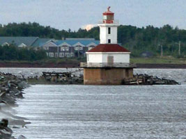
| PE 27A |
| Wood Islands Harbour Range
latitude N longitude E
Located on the east breakwater of the harbor within sight of the Wood Islands Light. ARLHS # CAN-57
Photo courtesy djbjr [webshots] |
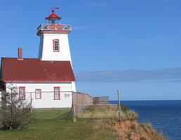
| PE 28 |
Point Prim
latitude 46° 3' 0.5" N longitude 63° 2' 20.4" W
On the Trans Canada Highway, look for the turn-off to Point Prim between Belfast and Pinette. At the end of the road turn left and drive through the woods to the lighthouse. The stairs leading to the top of the lighthouse are steep.
(Not to be confused with Prim Point in Nova Scotia) NS 8 ARLHS # CAN-809
Photo courtesy sarbo [Flickr] |
|
| PE 29 |
| Warren Cove Front Range (Fort Amherst)
latitude 46° 12' 26.1" N longitude 63° 8' 34.3" W
From Charlottetown drive west on the Trans Canada Route 1 to Cornwall. Turn onto Route 19 (Blue Heron Drive) and follow past Rocky Point. Turn towards Fort Amherst/Port La Joye National Historic Site. The lighthouse is in the park. ARLHS # CAN-130
Photo courtesy bigsister861 [webshots] |
| PE 29A |
Warren Cove Rear Range (Fort Amherst)
This is an outbound range for vessels leaving Charlottetown. Located on the west side of Charlottetown harbor. ARLHS # CAN-131
Photo courtesy bigsister861 [webshots] |
|
| PE 30 |
| Haszard Point Front Range (Tea Hill)
latitude 46° 11' 39.8" N longitude 63° 4' 26.4" W
On Route 1A between Cross Roads and Tea Hill look for a paved side road on the south side. At the end of this road you are close to the lighthouse. It is in a pasture just beyond, located on private property. (991) ARLHS # CAN-128
Photo courtesy Phil Maynard [webshots] |
| PE 30A |
Hazard Point Rear Range
Two pairs of range lights were established in 1889 to guide vessels into Charlottetown Harbour along a channel clear of all obstructions. The outer set of range lights, known as the Haszard Range Lights, was established southeast of the entrance to the harbour. ARLHS # CAN-129
Photo courtesy Phil Maynard [webshots] |
|
| PE 32 |
| Blockhouse Point (Rocky Point)
latitude 46° 11' 26.1" N longitude 63° 7' 46.2" W
Blockhouse Point Lighthouse is located on the west side of the entrance to Charlottetown Harbour, overlooking Northumberland Strait on the south shore of Prince Edward Island.
From Charlottetown travel west on the Trans Canada Route 1 to Cornwall. Turn onto Route 19, Blue Heron Drive and follow it around past Rocky Point. Turn off towards Fort Amherst/Port La Joye National Historic Site and follow the road right to the end, where you will end up in the lighthouse yard. (993) ARLHS # CAN-046
Photo courtesy djbjr [webshots] |
| PE 32 |
Brighton Beach Front Range
latitude 46° 13' 50.4" N longitude 63° 8' 51.2" W
Near Victoria Park in Charlottetown, look for Queen Elizabeth Drive and Brighton Road, and find the lane which goes to the shore opposite York Lane. (994) ARLHS # CAN-126
Photo courtesy Phil Maynard [webshots] |
|
| PE 33 |
| Brighton Beach Rear Range
latitude 46° 13' 51" N longitude 63° 8' 47.6" W
The light is on private property on Queen Elizabeth Drive. (995) ARLHS # CAN-127
Photo courtesy Phil Maynard [webshots] |
| PE 34 |
St. Peter's Island |
St. Peter’s Island is located on the western side of Hillsborough Bay near the entrance to Charlottetown Harbour.
It is rumored you can access the island at low tide. (1007) ARLHS # CAN-481 |
| PE 35 |
Victoria Harbour Front Range (Leards)
Turn off the Trans Canada Route 1 at Crapaud or Hampton and head to Victoria. This lighthouse is easily found near the wharf not far from Victoria Provincial Park. (1008) ARLHS # CAN-512
Photo courtesy Phil Maynard [Webshots] |
|
| PE 35R |
| Victoria Harbor Rear Range ARLHS # CAN-1042
Photo courtesy Phil Maynard [Webshots] |
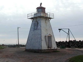
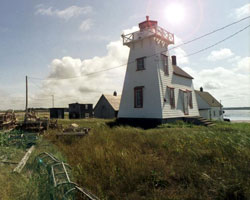
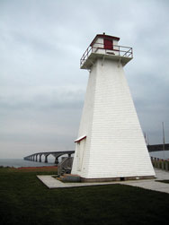
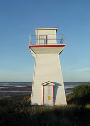
| PE 36 |
Port Borden Rear Range Light
This lighthouse was deactivated after the opening of the Confederation Bridge from Borden-Carleton to New Brunswick. It is now part of the Borden-Carleton Marine/Rail Historical Park. (1015) ARLHS # CAN-054
Photo courtesy jb18t [Flickr] |
|
| PE 37 |
Port Borden Pier Light
latitude 46° 14' 42.5" N longitude 63° 41' 58" W |
The lighthouse is on private property at the end of a pier; it is best viewed from the Borden-Carleton waterfront. (1017.5) ARLHS # CAN-052 |
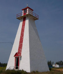
| PE 38 |
Seacow Head
The walrus was resident here in the late 19th century, thus the name.
Follow Blue Heron Drive between Bedeque and Borden-Carleton. Turn off on Route 119 to Fernwood. Continue to a "T" in the road. Form here you should be able to see the lighthouse. Follow the road down to it. (1018) ARLHS # CAN-453
Photo courtesy djbjr [webshots] |
|
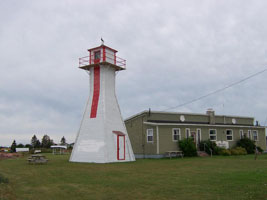
| PE 39A |
Summerside Front Range (Wharf)
The wooden front range tower remained in use until 1961, when it was replaced by a skeleton tower. ARLHS # CAN-488
Photo courtesy djbjr [webshots] |
|
| PE 40 |
| Indian Head
A somewhat better view can be obtained from McCallum's Point, across Summerside Harbour.
From Summerside, follow Highway 1A to Central Bedeque; take Route 171 to Bedeque, then Route 112 all the way to the end (the old Summerside Range Front Light can be seen along the way). (1020) ARLHS # CAN-248
Photo courtesy djbjr [webshots] |
| PE 41 |
Summerside Inner Range
From Summerside, follow Highway 1A to Central Bedeque; take Route 171 to Bedeque, then Route 112 to MacCallum's Point. The old Summerside Front Light will be visible through the trees on the left, about 5 miles from Bedeque (the pavement ends about 3.5 miles out of Bedeque). A narrow road leads to the property. Permission should be obtained before walking to the light. (1021) ARLHS # CAN-489
Photo courtesy Phil Maynard [webshots] |
|
| PE 42 |
| Cape Egmont
The lighthouse is on Cape Egmont Point, off Route 11. Turn at a curve in the road where the paved road goes to Fishing Cove Harbour, then follow the gravel road through the woods to the lighthouse. (1024) ARLHS # CAN-114
Photo courtesy djbjr [webshots] |
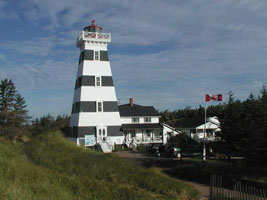
| PE 43 |
West Point
latitude 46° 37' 13.1" N longitude 64° 23' 11.9" W
The West Point Lighthouse is a comfortable Inn, located in beautiful Prince Edward Island.
Take Route 2 to the western side of Prince Edward Island, and then turn left onto Route 14. After 14.6 miles turn left onto Cedar Dunes Park Road which leads to the light. (1029) ARLHS # CAN-527
Photo courtesy djbjr [webshots] |
|
|
|
If you've read this far, you've probably figured out that I personally have not visited any of the lights on this page. If you have done so, and have updates to this page, please contact me so we can fix things. mailMe
 Nova Scotia