|
This page shows that portion of Lighthouses of Spain located in the Canary Islands. You can click on the photo of the light to go to it's specific (larger resolution) copy. Each lighthouse name is linked to (in our editorial opinion) the best reference site for that light. |
|
Isla de la Palma
| SP 203 |
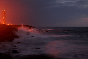
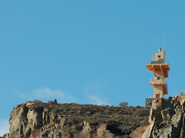
Punta Cumplida
latitude 28° 50' 20.5" N longitude 17° 46' 41.3" W
Located at the northeastern point of the Isla de la Palma, about 5 km northeast of Barlovento (the name of the town means "windward"). ARLHS # CAI-029
Photo courtesy Eneko Ametzaga [Flickr] |
|
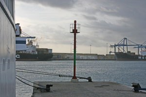
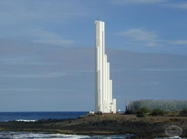
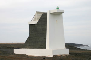
| SP 203C |
| Santa Cruz de La Palma
November 13, 2007
It's hard to call this a lighthouse as it has no door, but looking at the size of the people, I believe it's larger than the Funchal Breakwater in Madeira PT 81 |
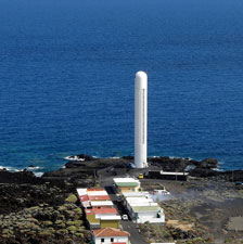
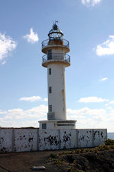
| SP 204 |
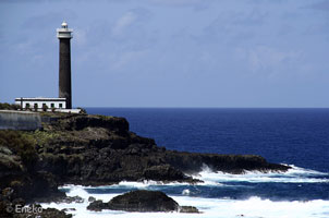
Arenas Blancas
latitude 28° 34' 11.4" N longitude 17° 45' 37.5" W
This is a very striking modern lighthouse. Located on the Playa de Arenas Blancas, on the southeastern coast of the island, about 8 km southeast of Mazo.
Photo courtesy H. H. Schueller [Flickr] |
|
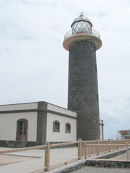
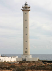
| SP 205 |
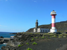
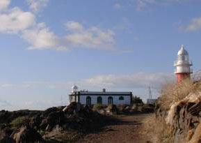
| Fuencaliente (1903)
latitude 28° 27' 19.5" N longitude 17° 50' 36.2" W
Located at the southern tip of the island, about 13 km south of Los Canarios, accessible by a road with many switchbacks. ARLHS # CAI-083 |
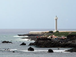
| SP 207 |
Punta Lava
latitude 28° 35' 47.9" N longitude 17° 55' 32.2" W
Located on the southwestern coast of the island, about 2 km northwest of Puerto Naos. ARLHS # CAI-042
Photo courtesy Eneko Ametzaga [Flickr] |
|
Isla del Hierro
| SP 208 |
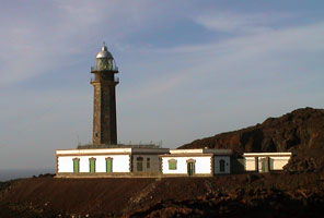
| Punta Orchilla
latitude 27° 42' 23.9" N longitude 18° 8' 50.8" W
Located at the southwestern tip of the island, which was once the end of the known world for Europeans. Accessible by a 25 km road (at least partly unpaved) from the town of Sabinosa. ARLHS # CAI-066
Photo courtesy Marcus Stöckl [wikipedia] |
Isla de la Gomera
| SP 210 |
San Cristóbal (new) |
This lighthouse is a shorter version of the newer Faro de Fuencaliente on Isla de la Palma. Located atop a precipitous headland just north of San Sebastián de la Gomera, the principal town and port of the Isla de la Gomera, on the east side of the island. ARLHS # CAI-054
Photo courtesy Gérard van Eyk [Flickr] |
Isla de Tenerife
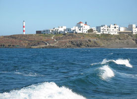
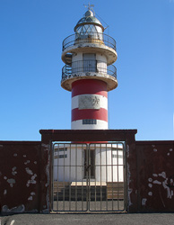
| SP 211 |
Abona (1902)
latitude 28° 8' 53.6" N longitude 16° 25' 37.7" W
Southeast side of Tenerife Island. White cylindrical tower with three red bands, two galleries, dwelling adjacent. ARLHS # CAI-081
Photo courtesy Gabor Ambrozy [Flickr] |
|
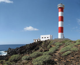
| SP 212 |
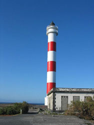
| Abona (new)
latitude 28° 8' 52.9" N longitude 16° 25' 38" W
This lighthouse is a taller version of the newer Faro de Fuencaliente on Isla de la Palma. Located on the southeastern coast of Tenerife, on a point of land about 2.5 km southeast of Poris de Abona. SP 206 ARLHS # CAI-022
Photo courtesy Gabor Ambrozy [wikipedia] |
| SP 213 |
Rasca (1914)
Southern tip of Tenerife Island. In the photo you can see it is located in front of the new lighthouse. ARLHS # CAI-085 |
|
| SP 214 |
Rasca (new)
latitude 28° 3.8" N longitude 16° 41' 39.6" W |
This lighthouse is a taller version of the newer Faro de Fuencaliente on Isla de la Palma. Located on the southernmost tip of Tenerife, about 15 km southeast of Los Cristianos. SP 206 ARLHS # CAI-050
Photo courtesy Jose Mesa [Flickr] |
| SP 215 |
Punta de Teno (1897)
latitude 28° 20' 29.6" N longitude 16° 55' 28" W |
Western tip of Tenerife Island. Located in front of the new lighthouse (below). ARLHS # CAI-084 |
|
|
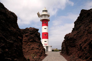
| SP 216 |
Punta de Teno (new)
latitude 28° 20' 31.3" N longitude 16° 55' 22.8" W
Located on the westernmost tip of Tenerife, about 11 km west southwest of Buenavista del Norte. Tim comments that in this photo, you see both the North side and the South side of the island at one time. ARLHS # CAI-033
Photo courtesy © Tim Smith [Flickr] |
|
| SP 217 |
Buenavista
latitude 28° 23' 28" N longitude 16° 50' 11.4" W |
Located on a promontory about 4 km northeast of Buenavista del Norte. ARLHS # CAI-004 |
| SP 218 |
Puerto de la Cruz
latitude 28° 25' 11.1" N longitude 16° 32' 59.4" W
Located at a point of land on the waterfront of Puerto de la Cruz, the principal city on the north coast of Tenerife.
Photo courtesy © Tim Smith [Flickr] |
|
| SP 219 |
| Punta del Hidalgo
Located on the waterfront in Punta del Hidalgo, a town near the east end of the northern coast of Tenerife. ARLHS # CAI-035
Photo courtesy sharose105 [Webshots] |
| SP 220 |
Punta de Anaga |
This historic lighthouse is the traditional landfall light for Tenerife. Located at the northeastern tip of the island; accessible, if at all, by lengthy and very crooked mountain roads. photo |
| SP 220N |
Santa Cruz de Tenerife Dique Nord
This Dike seems to be for protection only, there does not appear to be a walk way on it. |
|
| SP 220S |
| Santa Cruz de Tenerife Dique Sud
At the end of the main cruise ship dock, thus more than a mile from shore. This territory is secured, whether you could "ask permission to walk" I don't know. We had to show our boat passes. |
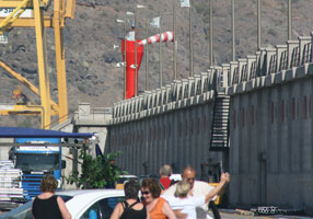
| SP 221 |
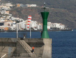
Santa Cruz de Tenerife Muelle Sur ("Farola del Mar")
latitude 28° 28' 9.8" N longitude 16° 14' 45.2" W
November 14, 2007
Located on the waterfront of Santa Cruz de Tenerife, the provincial capital, behind where the ferry docks. Current charts indicate this is no longer an aid to navigation. Our boat docked a very short walk from this light. |
|
Isla de Gran Canaria
| SP 222 |
| Punta Sardina
latitude 28° 9' 52.9" N longitude 15° 42' 28.4" W
Located at the northwestern corner of the island, about 2 km northwest of the town of Sardina. ARLHS # CAI-055
Photo courtesy Oxum [Flickr] |
| SP 223 |
La Isleta
latitude 28° 10' 26.6" N longitude 15° 25' 8.6" W
La Isleta is a mountainous peninsula extending northward from the city of Las Palmas. Located on the heights about 2.5 km north of the harbor of Las Palmas de Gran Canaria, at the northeastern corner of the island. ARLHS # CAI-008
Photo courtesy Pepelopex [wikipedia] |
|
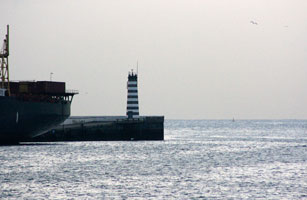
| SP 224 |
Dique Reina Sofía
latitude 28° 7' 16.5" N longitude 15° 24' 16.9" W |
Located at the end of the original breakwater of Puerto de la Luz, the main harbor of Las Palmas de Gran Canaria; the breakwater has been extended considerably and the light then stood at an elbow where the pier swerves southward. ARLHS # CAI-014 |
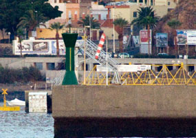
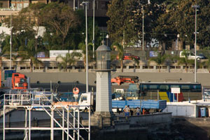
| SP 225 |
Dique de Léon y Castillo (Dique del Generalissimo Franco)
November 15, 2007
This light is on the mole at the southern end of the container ship terminal of Puerto de la Luz, the main harbor of Las Palmas de Gran Canaria. |
|
|
|
| SP 226 |
Punta de Melenara
latitude 27° 59' 30.3" N longitude 15° 22' 4.7" W
East coast of Gran Canaria Island. Located about 4 km southeast of San Borondón. (D 2807.5) ARLHS # CAI-057
Photo courtesy Alex Trabas [ListOfLights] |
|
| SP 229 |
Arinaga (3)
Located on a promontory at Playa de Arinaga, on the southeast coast of the island. ARLHS # CAI-024
Photo courtesy Jose Jolletas [Flickr] |
|
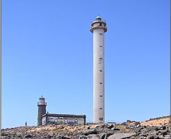
| SP 230 |
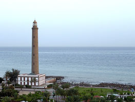
| Maspalomas
latitude 27° 44' 6.8" N longitude 15° 35' 56" W
This great lighthouse marks the southern tip of the Isla de Gran Canaria and is one of the island's best known tourist attractions. The surrounding area of sand dunes interspersed with wetlands is a protected nature reserve. Located about 4 km south of the town of Maspalomas. ARLHS # CAI-018
Photo courtesy R. Duran [Flickr] |
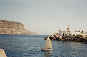
| SP 231 |
Puerto de Mogán
latitude 27° 48' 56.5" N longitude 15° 45' 48.8" W
Located at the end of the breakwater at Puerto de Mogán, the only protected harbor on the southwestern coast of Gran Canaria. (D 2815.96) ARLHS # CAI-061
Photo courtesy Alex Trabas [ListOfLights] |
|
| SP 232 |
| Punta del Castillete
latitude 27° 44' 54.6" N longitude 15° 40' 9.7" W
This somewhat ungainly modern lighthouse marks the southwestern corner of the island. Located about 12 km southwest of Mogán, accessible by mountainous roads. ARLHS # CAI-006
Photo courtesy Pepelopex [wikipedia] |
Isla de Fuerteventura
| SP 233 |
Punta Pesebre
latitude 28° 6' 34.6" N longitude 14° 29' 27.1" W
Located on the northern tip of the peninsula at the extreme southwestern end of the island; accessible by 4WD. (D 2791) ARLHS # CAI-067
Photo courtesy Alex Trabas [ListOfLights] |
|
| SP 234 |
| Jandía
latitude 28° 3' 56.9" N longitude 14° 30' 25.8" W
Located at the end of a barren peninsula at the extreme southwestern tip of the island; accessible by 4WD. ARLHS # CAI-040
Photo courtesy Martinella [Flickr] |
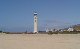
| SP 235 |
Morro Jable
latitude 28° 2' 45.4" N longitude 14° 19' 59" W
Morro Jable is a popular resort town at the southernmost point of the island. Located on the beach, near the resorts. ARLHS # CAI-093
Photo courtesy Sebastian Schwittay [Flickr] |
|
| SP 236 |
Punta La Entellada (Punta Lantailla) |
Located about 6 km east of Las Playitas on the southeast coast of the island. |
| SP 237 |
Gaviota (Puerto del Rosario)
latitude 28° 30' 19.3" N longitude 13° 50' 37.6" W
This is the landfall light for Puerto del Rosario, the principal town and port of the Isla de Fuerteventura. Located on the Punta Gaviota on the east side of Puerto del Rosario. (D 2793.5) ARLHS # CAI-064
Photo courtesy Alex Trabas [ListOfLights] |
|
| SP 238 |
Punta Martiño (Islote de Lobos)
latitude 28° 45' 53.5" N longitude 13° 48' 53.7" W |
The Isla (or Islote) de Lobos is a 1160 acre island located off the northeastern tip of Fuerteventura. The entire island has been protected since 1982 as a nature preserve, but most of it is open to visitors. Boat transportation is available from Corralejo on the north coast of Fuerteventura. Located on the northeastern tip of the island, marking the south side of the Bocaina Channel separating Fuerteventura from Lanzarote. photo ARLHS # CAI-005 |
| SP 239 |
Tostón (1897) (Punta de la Ballena) |
On Punta de la Ballena, NW coast of Fuerteventura Island ARLHS # CAI-088 |
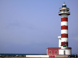
| SP 240 |
Tostón (1950s) (Punta de la Ballena)
latitude 28° 42' 56.1" N longitude 14° 48.8" W
You can see the old lighthouse (white tower) behind the new (striped tower) one. ARLHS # CAI-087 |
|
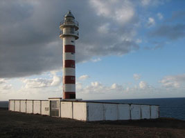
| SP 241 |
Tostón (1986) (Punta de la Ballena)
latitude 28° 42' 55.5" N longitude 14° 49.5" W |
ARLHS # CAI-058
Photo courtesy Eneko Ametzaga [Flickr] |
Isla de Lanzarote
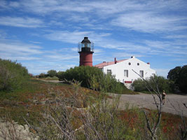
| SP 242 |
Pechiguera (1866)
Southern tip of Lanzarote Island. (Note that this photo is cropped to fit this space. The original is much better looking (but shows less of the lighthouses.)) ARLHS # CAI-069
Photo courtesy Michael S. Schwarzer [Flickr] |
|
| SP 243 |
Pechiguera (1988) |
This lighthouse stands on the southernmost point of Lanzarote, marking the north side of the Bocaina Channel separating Fuerteventura from Lanzarote. Located about 4 km west of Baja Montaña. ARLHS # CAI-047 |
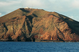
| SP 244 |
Punta Delgada (Isla de Alegranza)
latitude 29° 24' 11.8" N longitude 13° 29' 18.9" W
The Isla de Alegranza is the northernmost land of the Canary Islands, located about 25 km north of Lanzarote. Most of the island is occupied by the caldera of a dormant volcano. Boat transportation to Alegranza is available from Órzola at the northern end of Lanzarote. Lighthouse located at the northeastern point of the island. ARLHS # CAI-034
Photo courtesy Prissantenbär [wikipedia] |
|
|
|