|
The lights of Romania. As with Bulgaria, these are all on the Black Sea. |
|
| RO 1 |
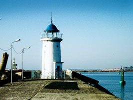
Mangalia Southeast Breakwater Head
latitude 43° 47' 56.1" N longitude 28° 35' 37" E |
Located at the end of the south breakwater pier at Mangalia, a broad pier with a road. photo ARLHS # ROM-014 |
| RO 2 |
Mangalia Northeast Breakwater Spur
latitude 43° 48' 4.2" N longitude 28° 35' 42.9" E |
Located at the end of the extended northeast breakwater. photo ARLHS # ROM-013 |
| RO 3 |
Mangalia Northeast Breakwater
latitude 43° 48' 12.5" N longitude 28° 35' 20.3" E
This lighthouse became obsolete when the northeast breakwater was extended and the southeast breakwater constructed, considerably expanding the harbor. Located at the end of the original northeast breakwater at Mangalia. ARLHS # ROM-006
Photo courtesy Andrea FERRER [Flickr] |
|
| RO 4 |
Mangalia
latitude 43° 48' 39.3" N longitude 28° 33' 32.1" E |
ARLHS # ROM-005 |
| RO 5 |
Capul Tuzla
latitude 43° 59' 26.8" N longitude 28° 39' 59.2" E |
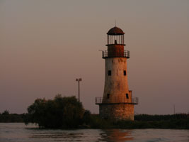
This historic lighthouse was prefabricated in France by Barbier, Bernard, et Turenne. Possibly endangered: the lighthouse is reported to be in danger due to erosion of the bluff on which it stands, although it seems fairly secure. There are plans to move it, but no funds are available for the project. Located on Capul (Cape) Tuzla, about 4 km southeast of Eforie Sud. photo |
| RO 7 |
Constantsa South Breakwater
latitude 44° 8' 48.9" N longitude 28° 40' 8.6" E |
This light and the East Breakwater Spur Light frame the entrance to the inner (north) harbor of Constanţa. Located at the end of a pier on the west (mainland) side of the harbor. ARLHS # ROM-016 |
| RO 8 |
Constanta Outer Harbour East Breakwater Traverse Arm
latitude 44° 8' 51.3" N longitude 28° 40' 20" E |
This light and the South Breakwater Light frame the entrance to the inner (north) harbor of Constanţa. Located at the end of a westward spur off the East (outer) Breakwater. ARLHS # ROM-010 |
|
|
| RO 9 |
Constanta Outer Harbour South Breakwater Head |
ARLHS # ROM-011 |
| RO 10 |
Constantsa East Pier (King Carol I)
latitude 44° 9' 28.3" N longitude 28° 39' 26.2" E |
The lighthouse was built to honor King Carol I, who died in 1914. It is known locally simply as the farul vechi (the old lighthouse). Located at the end of the old East Pier, which is now the root of the city-s outer breakwater. Accessible by walking or driving the pier, about 1.5 km south from the Casino. photo ARLHS # ROM-017 |
| RO 11 |
Constanta Old Tower |
ARLHS # ROM-003 |
| RO 12 |
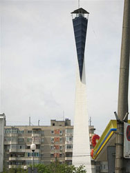
Constanta
latitude 44° 9' 29" N longitude 28° 37' 49.9" E
This striking modern lighthouse is located at the center of a broad plaza just west of the harbor area. The tower and its surrounding fountains are floodlit at night. ARLHS # ROM-002
Photo courtesy dre04mach [Flickr] |
|
| RO 13 |
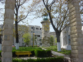
| Genovez (Constanta)
latitude 44° 10' 19.6" N longitude 28° 39' 53" E
This historic lighthouse was restored in 1948 and has become a fairly well known tourist attraction. It stands near the Casino on a headland projecting into the Black Sea north of the harbor but close to Constanţa's downtown business district. ARLHS # ROM-015
Photo courtesy Jackson Lee [Flickr] |
| RO 14 |
Tomis Southeast Breakwater
latitude 44° 10' 41.4" N longitude 28° 39' 44.8" E |
The Tomis small craft harbor adjoins downtown Constanţa on the north side of the Casino area. Located at the end of the southeast breakwater of Tomis harbor. Flickr |
|
|
| RO 15 |
Tomis Northeast Breakwater
latitude 44° 10' 41.4" N longitude 28° 39' 44.8" E |
Located at the end of the northeast breakwater of Tomis harbor. Flickr |
| RO 16 |
Constantsa Marina East (Tomis East Breakwater) |
ARLHS # ROM-021 |
| RO 17 |
Constantsa Marina Northeast (Tomis Northeast Breakwater) |
ARLHS # ROM-022 |
| RO 18 |
Midia West Breakwater |
Capul (Cape) Midia is a headland at the extreme southern end of the Danube Delta, about 20 km north of Constanţa. An artificial harbor has been constructed south of the cape as a satellite to the Port of Constanţa. Located at the end of the west breakwater at Midia. photo |
| RO 19 |
Midia East Breakwater Spur |
Located at the end of a short spur off the east breakwater at Midia, opposite the west breakwater light. photo |
| RO 20 |
Midia Entrance (East Breakwater)
latitude 44° 19' 16.6" N longitude 28° 41' 41" E |
Located at the end of the east breakwater. photo |
| RO 21 |
Midia Main (Capul Midia)
latitude 44° 20' 53.8" N longitude 28° 41' 17.3" E |
Located on the headland of the cape, a short distance north of the harbor. ARLHS # ROM-001 |
| RO 22 |
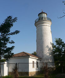
Sfintu Gheorghe (Gura Sf. Gheorghe)
latitude 44° 53' 59.4" N longitude 29° 36' 0.2" E |
The Sfântu Georghe (St. George) Branch is the southernmost of the main mouths of the Danube River. The original lighthouse stood on the other side of the river until it was burned by arsonists in 1980; the Fresnel lens from that lighthouse is preserved at the Naval Museum (Muzeul Marinei Române) in Constanţa. Located on the north side of the river in the village of Sfântu Gheorghe. photo ARLHS # ROM-007 |
| RO 23 |
Sulina (1856) (Black Sea)
The Sulina Branch of the Danube is the only mouth navigable by modern ships. Sedimentation has moved the entrance to the river considerably to the east, leaving this historic lighthouse high and dry. Located on the south bank of the river in the town of Sulina. ARLHS # ROM-019
Photo courtesy Mmiszka [wikipedia] |
|
| RO 24 |
Sulina (1983)
latitude 45° 8' 53.6" N longitude 29° 45' 33.1" E |
This large tower serves as the entrance control station for ships arriving at the mouth of the Danube. It is built on a triangular artificial island attached near the end of the south breakwater at the river entrance. Flickr ARLHS # ROM-008 |
| RO 25 |
Sulina South Pier
latitude 45° 9' 34.9" N longitude 29° 40' 46.2" E |
This abandoned lighthouse appears to be in poor condition. Located on the old south pier at Sulina, now about 2.5 km west of the actual mouth of the river. webshots ARLHS # ROM-020 |
| RO 26 |
Sulina North Pier (Black Sea)
This abandoned lighthouse is in poor condition. Located on what remains of the old north pier at Sulina. ARLHS # ROM-018
Photo courtesy Neagrigore [Flickr] |
|
| RO 27 |
Gura Portita Fairway South Side (Portitei, Gura Portiţei)
latitude 44° 40' 31.5" N longitude 28° 59' 15.4" E |
The light station is built on a barrier beach that encloses a large lagoon on the south side of the Danube entrances. It was built on the south side of an inlet, but satellite photos indicate that the inlet has closed. Located about 50 km northeast of Constanţa and a similar distance southwest of Sfântu Gheorghe. photo ARLHS # ROM-012 |
|
|

 Russia
