latitude 56° 14' 45.8" N
longitude 5° 40' 10.8" W
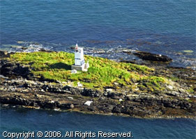
The name, which means Black Rock in Gaelic, should be Sgeir Dubh, but the incorrect word order is traditional on light lists. Located about 800 m west of Cullipool on the largest of several rocky islets in the north end of the Sound of Luing. Accessible only by boat. ARLHS # SCO-061 (A 4192)
| home | Scotland lights | map this |
| prev | region page | next |
| UK/ScotlandN () / Scotland SC49H |