latitude 36° 22' 35.9" N
longitude 75° 49' 51.4" W
September 16, 2013
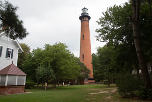
Built in 1873, the walls at the bottom are 5' thick and at the top they are still 3' thick. People coming down from the tower kept saying "214 steps up and 214 steps down". Since the line was long, we chose to look around and leave.
Take highway 158 onto the barrier islands and then 20 miles north on route 12. Be prepared for slow traffic and much of it. Turn left where it says "lighthouse". ARLHS # USA-212 (J 2384)
| home | SouthAtlantic lights | map this |
| prev | region page | next |
| ECU/sAtlantic () / SouthAtlantic NC1 |