|
This page currently shows thebeginning of the documentation of the Lighthouses of Panama. In addition, the pictures below are linked to the relevant photo on the web (thus making available to you a higher resolution picture.) I am very grateful to Russ Rowlett at the University of North Carolina for his excellent Lighthouse Directory for the outline. Each lighthouse is linked to (in our editorial opinion) the best reference site for that light. LHdirectory I would like to include directions on how to get to these lights. If you know such data, could you eMail me and I'll post it here (with your choice of attribution.) mailMe |
|
Atlantic Coast
| PN 1 |
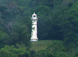
Isla Grande |
The lighthouse is a twin of the Toro Point Light (see below). This is a landfall light for ships arriving at the Canal from the northeast. Located at the highest point of Isla Grande, a resort island off Punta Manzanillo, about 80 km northeast of the Canal entrance. Accessible by a 30 minute walk from the town and from nearby resorts. Toro ARLHS # PAN-026 |
| PN 2 |
Farallón Sucio Rock |
The original tower was a 20 ft white, pyramidal steel framework tower on a tank house. Located about 6 mi west northwest of Isla Grande. ARLHS # PAN-023 |
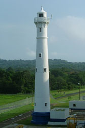
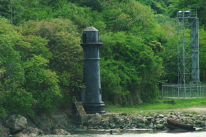
| PN 3 |
Toro Point |
This elegant lighthouse was built by the French during their efforts to construct the Canal. It is a familiar landmark for everyone passing through the waterway. Located on the west side of the entrance to Limon Bay from the Caribbean. Accessible by road. ARLHS # PAN-012 |
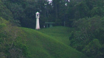
| PN 4 |
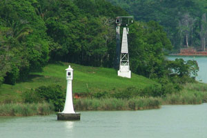
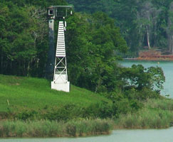
Atlantic Entrance Range Middle
Located about 100 m east of the Canal near the southbound entrance to the Gatún Locks.
Photo courtesy Larry Myhre [Flickr] |
|
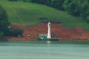
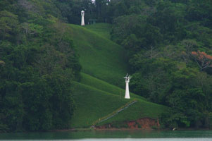
| PN 5 |
| Atlantic Entrance Range Rear
This lighthouse faces southbound (Pacific-bound) ships approaching the Gatún Locks from the Atlantic side. Located on Lighthouse Road in the town of Gatún, roughly 500 m east of the Gatún Locks and 1.2 km south of the middle range light.
Photo courtesy tispwisp [webshots] |
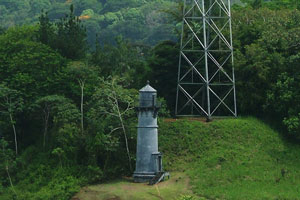
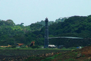
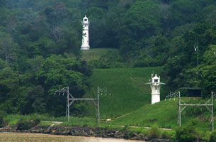
| PN 6 |
Gatún Northbound Rear (Gatún Locks)
This lighthouse is the rear light of the range for northbound (Atlantic-bound) ships approaching the Gatún Locks from Gatún Lake. ARLHS # PAN-014
Photo courtesy Larry Myhre [Flickr] |
|
Gatún Lake Range
| PN 7 |
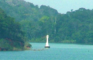
| Gatún Southbound Front
Located on a concrete pier just off a peninsula projecting into the south side of Gatún Lake; this is the peninsula separating the two principal branches of the lake. Accessible only by boat.
Photo courtesy Larry Myhre [Flickr] |
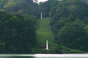
| PN 8 |
Gatún Southbound Rear |
This substantial lighthouse is located deep in the jungle about ½ mi south of the front light; a cleared corridor connects the two lights. The site is accessible by boat along a twisting side channel of the lake. ARLHS # PAN-029 |
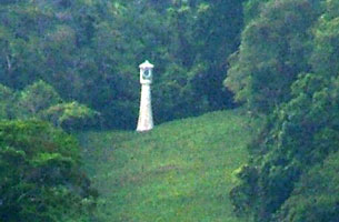
| PN 9 |
Peña Blanca Southbound Front
Located on a peninsula projecting into the lake on the north side of Barro Colorado Island.
Photo courtesy Larry Myhre [Flickr] |
|
| PN 10 |
| Peña Blanca Southbound Rear
Located at the end of a cleared corridor on the north side of Barro Colorado Island, about 600 m southeast of the front light.
Photo courtesy Larry Myhre [Flickr] |
| PN 11 |
Buena Vista Northbound Front
Located on the east side of the canal near the end of the Bohio Peninsula projecting into the central part of Gatún Lake ARLHS # PAN-034
Photo courtesy Larry Myhre [Flickr] |
|
|
|
| PN 14 |
Tabernilla Northbound Rear |
Located on the south side of the Bohio Peninsula near its base, northwest of Frijoles and about 800 m north of the front light. |
| PN 17 |
San Pablo Northbound Front
Located just offshore of Caño Quebrado Point near the southeast corner of the lake; this is where northbound ships enter the wider waters of the lake and southbound ships enter the narrow section of the Canal. ARLHS # PAN-037
Photo courtesy Larry Myhre [Flickr] |
|
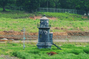
| PN 18 |
| San Pablo Northbound Rear
a skeletal tower with white panels as a daymark.
Note the original light on the left, now badly corroded.
Photo courtesy Larry Myhre [Flickr] |
|
|
Gamboa Area
| PN 21 |
Mamei Curve Northbound Front |
The range helps guide northbound ships through the middle portion of the Mamei Curve, which connects the San Pablo and Gamboa Reaches. Located on the east side (really the north bank) of the Canal about 1000 m west of the Gamboa Northbound Front Light. ARLHS # PAN-036 |
| PN 22 |
Gamboa Northbound Front
Located about 6 km west of Gamboa, marking the end of the Gamboa Northbound Reach leading into Gatún Lake.
Photo courtesy Larry Myhre [Flickr] |
|
| PN 23 |
| Gamboa Northbound Rear
latitude 9° 7.9" N longitude 79° 35' 15.6" W
Located a short distance east of Darien marking the end of the westward Gamboa Reach leading into Gatún Lake.
Photo courtesy Larry Myhre [Flickr] |
Milaflores & Balboa Area
| PN 26 |
Balboa (Miraflores) Northbound Rear |
The lighthouse is located about 500 m east of the Miraflores Locks in an area crossed by powerlines. The main road paralleling the canal passes the lighthouse. ARLHS # PAN-030 |
| PN 29 |
Balboa Southbound Front |
This range guided ships leaving the Miraflores 4 Locks and departing the Canal. The range was probably deactivated around 1962, when the Bridge of the Americas was completed, since the lights of the bridge now dominate this area. Located on the west side of the Canal channel just north of the bridge in Balboa. ARLHS # PAN-038 |
| PN 30 |
Balboa Southbound Rear
This light is located perhaps 100 m south of the Pacific Entrance Range Front Light. Located on the west side of the Canal just south of the Bridge of the Americas in Balboa. ARLHS # PAN-039
Photo courtesy Larry Myhre [Flickr] |
|
| PN 31 |
Flamenco Island (Pacific Signal Station) |
The island is connected to the mainland by a bridge and causeway, but we do not know if this crossing is open to the public. ARLHS # PAN-024 |
Pacific Coast
| PN 32 |
Punta Mala (1914) |
The abandoned lighthouse was in very poor condition until the government of Panama restored it in 2000. Located at the foot of a headland at the west entrance to the Gulf of Panama about 175 km southwest of the Canal entrance. ARLHS # PAN-013 |
| PN 33 |
Punta Mala (new) |
Located atop the headland at Punta Mala. |
| PN 34 |
Frailes del Sur |
Located on a rocky islet about 25 km southwest of Punta Mala. ARLHS # PAN-025 |
|
|
 Central America