|
This page shows the documentation about the Lighthouses of the Lesser Antilles Islands. In addition, the pictures below are linked to the relevant photo on the web (thus making available to you a higher resolution picture.) I am very grateful to Russ Rowlett at the University of North Carolina for his excellent Lighthouse Directory from which I built the outline. Each lighthouse is linked to (in our editorial opinion) the best reference site for that light. LHdirectory |
|
St. Martin
| AN 1 |
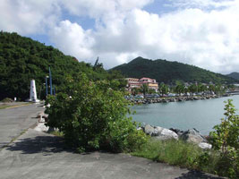
Marigot
latitude 18° 4' 15.7" N longitude 63° 5' 11.8" W
Located on a bluff guiding ships into the harbor of Marigot, the principal town of the French portion of the island of Saint-Martin, on the northwestern coast of the island. (J 5658) ARLHS # STM-001
Photo courtesy Arno Siering [ListOfLights] |
|
St. Barthélemy
| AN 2 |
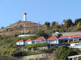
| Gustavia
latitude 17° 54' 3.4" N longitude 62° 51' 5.3" W
Located atop a hill at the site of historic Fort Gustave overlooking Gustavia harbor on the west side of the island of St. Barthélemy ('St. Barts'). ARLHS # STM-002
Photo courtesy Mike Schinkel [Flickr] |
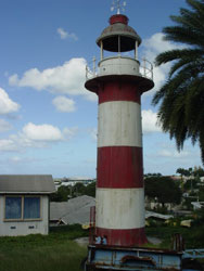
Antigua and Barbuda
| AN 3 |
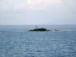
Sandy Island
latitude 17° 8' 3.6" N longitude 61° 55' 34.7" W
Located on a low island off the entrance to the harbor of St. John's, Antigua. (J 5690) ARLHS # ANT-001
Photo courtesy Arno Siering [ListOfLights] |
|
| AN 4 |
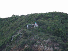
| Pillar Rock
latitude 17° 7' 41.9" N longitude 61° 52' 44.3" W
Located on a promontory on the northwest coast of Antigua, about 4 km west of the St. John's waterfront (J 5694) ARLHS # ANT-002
Photo courtesy Arno Siering [ListOfLights] |
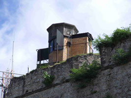
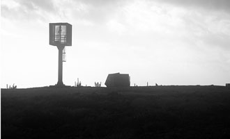
| AN 4S |
St. John's
This light was apparently built as part of a project to develop a large sugar refinery near St. John's. It was intended as the rear light of a range, but it proved to be in the wrong position for that purpose, and it was never commissioned. Located on a hill several blocks behind the waterfront of St. John's.
Photo courtesy Douglas Cameron [theCamerons] |
|
Martinique
| AN 5 |
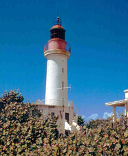
| La Caravelle
latitude 14° 46' 28.7" N longitude 60° 52' 32.8" W
The lighthouse occupies a spectacular site overlooking the Atlantic. Located at the eastern end of the Caravelle Peninsula east of Trinité, in the Martinique Regional Nature Park. It's about a 2 hour walk to get to the light. park ARLHS # MRQ-002
Photo courtesy muzei [Flickr] |
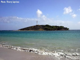
| AN 6 |
Îlet Cabrit
Located on a small island off the south tip of Martinique. Accessible only by boat. ARLHS # MRQ-001
Photo courtesy Thierry Leprince [Carceller] |
|
| AN 7 |
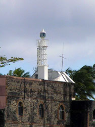
| Fort Saint-Louis
latitude 14° 35' 57.3" N longitude 61° 3' 59.7" W
The 18th century Fort St.-Louis is built on a peninsula barring entry to the inner harbor of Fort-de-France, Martinique's capital. The lighthouse is built high atop the stone walls of the fort. The fort is open to guided tours. (J 5783) ARLHS # MRQ-005
Photo courtesy Peter Mosselberger [ListOfLights] |
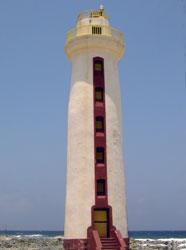
| AN 9 |
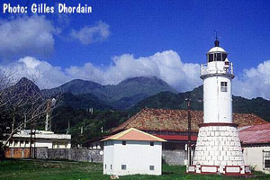
| Le Prêcheur
Located on the northwestern coast of Martinique at the foot of the infamous volcano Pelée. ARLHS # MRQ-004
Photo courtesy Gilles Dhourdain [Carceller] |
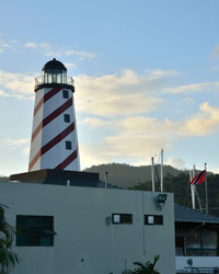
St. Lucia
| AN 10 |
Vigie
latitude 14° 1' 20.6" N longitude 61° 5.3" W
Located on the Vigie peninsula, the north side of the harbor of Castries. (J 5791) ARLHS # STL-004
Photo courtesy Arno Siering [ListOfLights] |
|
| AN 11 |
| Tapion Rock
Located atop an isolated rock outside the harbor of Castries. Inaccessible, but there are good views from ships arriving or leaving.
Photo courtesy ajean999 [webshots] |
| AN 13 |
Cul de Sac Bay Front Range |
ARLHS # STL-002 |
| AN 14 |
Cul de Sac Bay Rear Range |
ARLHS # STL-003 |
St. Vincent
| AN 15 |
Fort Charlotte
The site offers an outstanding view southwestward toward the Grenadines. Located atop Berkshire Hill on the west side of Kingstown, St. Vincent's capital. The fort is open to guided tours. ARLHS # STV-001
Photo courtesy Anonymous [webshots] |
|
Grenada
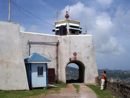
| AN 16 |
| Fort George
Fort George is now the local police headquarters. Located on the north side of the entrance to the harbor of St. George's, the capital of Grenada. (J 5834) ARLHS # TRI-003
Photo courtesy Arno Siering [ListOfLights] |
| AN 16S |
Pointe Saline
Sadly, the light was deactivated and the tower demolished in the early 1980s.
Photo courtesy (1974) Paul Legros [webshots] |
|
| AN 17 |
Västra Banken Swedish Lightship 23 |
Located at Le Phare Bleu Marina on the south coast of Grenada, 5.5 km southeast of St. George's. |
|
|
Barbados
| AN 18 |
Ragged Point (East Point)
latitude 13° 9' 49.3" N longitude 59° 25' 58.5" W
Located on a bluff above the Atlantic about 2 km northwest of East Point, the easternmost point of the island. ARLHS # BAR-003
Photo courtesy anonymonk [Flickr] |
|
| AN 19 |
| South Point Gordon's
latitude 13° 2' 49.6" N longitude 59° 31' 45.8" W
Located near the southernmost point of the island. ARLHS # BAR-004
Photo courtesy Wayne Jackson [Flickr] |
| AN 20 |
Needhams Point
Located at the south end of Carlisle Bay, southwest of Bridgetown; the light is just below the hotel. ARLHS # BAR-002
Photo courtesy Holly Popowski [Flickr] |
|
| AN 21 |
| Harrison Point
latitude 13° 18' 30.2" N longitude 59° 38' 54.2" W
Located at the northwesternmost point of the island, about 8 km north of Speightstown. ARLHS # BAR-001
Photo courtesy El Ramon [Flickr] |
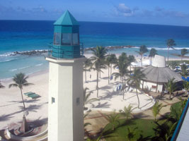
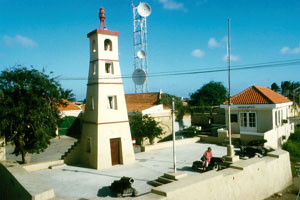
Aruba
| AN 22 |
California (Noordwestpunt, Hudishibana)
latitude 12° 36' 49" N longitude 70° 3' 4.2" W
Located at the northern point of the island near Malmok. Accessible by car. Aruba Vacation Services offers tours that include this lighthouse. tours ARLHS # ARU-001
Photo courtesy Maddox [Flickr] |
|
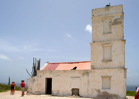
| AN 23 |
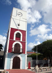
| Oranjestad (Fort Zoutman, Willem III Tower)
latitude 12° 31' 4" N longitude 70° 2' 8.6" W
Restored in 1983, the tower now houses the Historical Museum of Aruba. museum
Photo courtesy Stephan de Prouw [Flickr] |
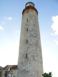
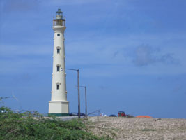
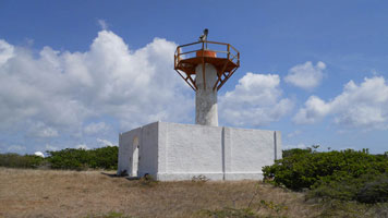
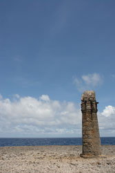
| AN 24 |
Ceru Colorado (Seroe Colorado)
latitude 12° 25' 7.9" N longitude 69° 52' 8.9" W
Located at the southeastern tip of the island. While the site is open, it is hard to find. ARLHS # ARU-002
Photo courtesy Stephan de Prouw [Flickr] |
|
Curaçao
| AN 25 |
| Noordpunt
latitude 12° 23' 2.3" N longitude 69° 9' 13.4" W
Located at the northwestern tip of the island ARLHS # NEA-008
Photo courtesy Jos Sanders |
| AN 26 |
Kaap Sint Marie (Bullenbaai) |
Located on the west side of the island about 8 miles northwest of Willemstad. This is now private property ARLHS # NEA-004 |
| AN 27 |
Riffort (Willemstad) |
The fort is now a shopping center, and the building with the lantern is a restaurant. ARLHS # NEA-010 |
| AN 28 |
Punt Kanon (Oostpunt)
Located on the southeastern tip of Curaçao. Visible from the water only as it is on private property. ARLHS # NEA-009
Photo courtesy Captain Theo [liteslist] |
|
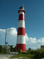
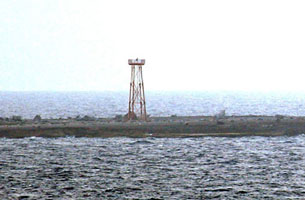
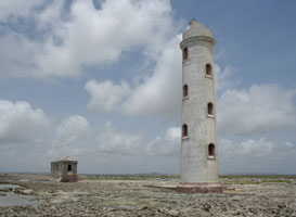
| AN 29 |
| Klein Curaçao
latitude 11° 59' 23.2" N longitude 68° 38' 35.3" W
The light station buildings are the only structures on the barren island, located 11 km off the southeastern tip of Curaçao. Accessible only by boat. ARLHS # NEA-006
Photo courtesy Stephan de Prouw [Flickr] |
Bonaire
| AN 30 |
Malmok
latitude 12° 18' 40.8" N longitude 68° 23' 24.1" W
Located at the northern tip of the island. ARLHS # NEA-001
Photo courtesy Keith Sheridan [Flickr] |
|
| AN 31 |
| Ceru Bentana (Seru Bentana, Ricado Winklar)
latitude 12° 18' 18" N longitude 68° 22' 34" W
Located on a rocky headland several miles east southeast of Malmok, near the northern tip of the island in the Washington Slagbaai National Park. ARLHS # NEA-002
Photo courtesy Jos Sanders |
| AN 32 |
Boca Spelonk
latitude 12° 12' 43.7" N longitude 68° 11' 47.8" W
Located on the northeast side of the island. Accessible only by foot or 4WD. ARLHS # NEA-001
Photo courtesy Jos Sanders [panoramio] |
|
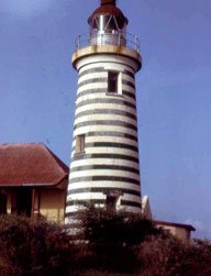
| AN 33 |
| Kralendijk (Fort Oranje)
latitude 12° 8' 55.5" N longitude 68° 16' 36.3" W
The light station now serves as the harbor master's office. Located in a seventeenth century fort at Kralendijk on the west side of the island. ARLHS # NEA-007
Photo courtesy Klaus Kern [liteslist] |
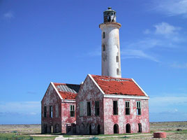
| AN 34 |
Lacre Punt (Willemstoren)
latitude 12° 1' 41.7" N longitude 68° 14' 14.2" W
Located at the southern tip of the island. ARLHS # NEA-012
Photo courtesy Sue Hedtke [picasaweb] |
|
Tobago
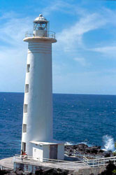
| AN 35 |
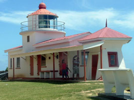
| Scarborough (Fort King George)
latitude 11° 10' 38.3" N longitude 60° 43' 36.5" W
Fort and lighthouse are built on a hill commanding Bacolet Bay, the harbor of Scarborough, near the southwestern tip of Tobago. ARLHS # TRI-003
Photo courtesy wolann [webshots] |
|
|
| AN 36 |
Crown Point
latitude 11° 8' 54.6" N longitude 60° 50' 36.9" W |
Located at the southwestern tip of the island, adjacent to the runway of the international airport. ARLHS # TRI-007 |
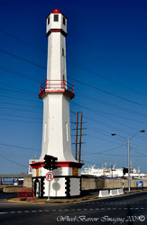
Trinidad
| AN 37 |
Port-of-Spain (St. Vincent Jetty Range Rear Range)
The lighthouse was built at the base of the St. Vincent Jetty, but since then the shoreline has been extended and the original purpose of the light has been lost. Located in the median of the waterfront street in downtown Port-of-Spain ARLHS # TRI-008
Photo courtesy Willaim Barrow [wheelbarrowimaging] |
|
| AN 38 |
| Crew's Inn Marina
The lighthouse was built by Colin Barcant to help guide yachts into the docking area of Chaguaramas Bay, a very popular sheltered anchorage at the northwestern corner of Trinidad.
Photo courtesy William Barrow [wheelbarrowimaging] |
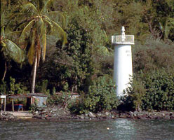
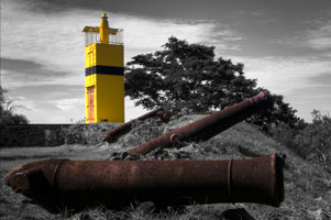
| AN 39 |
Point Baleine (Espalon Point) |
Located on the southwest point of Gaspar Grande Island, just off Chaguaramas Bay. Accessible only by boat. ARLHS # TRI-009 |
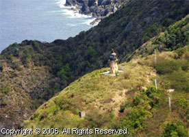
| AN 40 |
Chacachacare
latitude 10° 41' 56" N longitude 61° 45' 6.9" W |
The lighthouse, one of the highest in the Americas, is built atop a steep mountain with a spectacular view. Located on the island of Chacachacare in the Dragon's Mouth strait, off the northwesternmost tip of Trinidad. Accessible only by boat; tours available from Chaguaramas. ARLHS # TRI-002 |
| AN 41 |
Galera Point (Toco)
Located at the northeastern tip of Trinidad, east of Toco. ARLHS # TRI-004
Photo courtesy Orthmar Raoul Traninger [Flickr] |
|
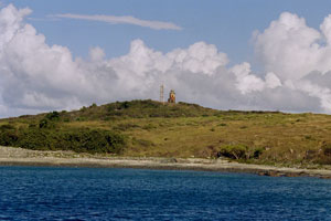
| AN 42 |
Brigand Hill
latitude 10° 29' 44.6" N longitude 61° 4' 4.9" W |
The lighthouse shares the site with a large TV/radio transmission facility. Located on a ridgetop on the east side of Trinidad, overlooking the Atlantic. ARLHS # TRI-001 |
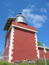
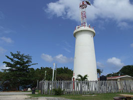
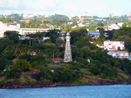
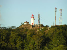
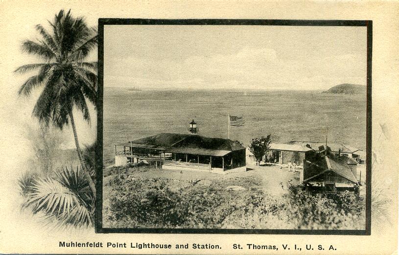
US Virgin Islands
| AN 43 |
Buck Island
Located at the highest point of Buck Island, about 3 mi south of St. Thomas. The island has been a wildlife refuge since 1969. Accessible only by boat. ARLHS # VIR-002
Photo courtesy M.G. Nelson [Flickr] |
|
| AN 45 |
Hams Bluff
latitude 17° 43' 32.9" N longitude 64° 53' 13.2" W
Located on the northwestern coast of St. Croix, marking the approach to the harbor of Fredericksted. ARLHS # VIR-001
Photo courtesy marinas.com [Marinas.com] |
|
| AN 46 |
Fort Louise Augusta (Christiansted Entrance Rear Range)
latitude 17° 45' 18.5" N longitude 64° 41' 39.6" W |
Located on a promontory at the north end of Christiansted harbor. The active range light is mounted on a 17 ft skeletal tower nearby. ARLHS # VIR-006 |
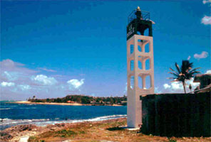
Guadeloupe
| AN 47 |
La Désirade |
The original lighthouse was a cast iron skeletal tower with lantern and gallery. Located at the eastern end of the island of La Désirade, which is east of the main island of Guadeloupe. photo ARLHS # GUA-005 |
| AN 48 |
Le Moule (Port du Moule)
Located on the west side of the entrance to Le Moule, a small port and resort town on the northeast coast of Grande Terre. (J 5722)
Photo courtesy Klaus Potschien [ListOfLights] |
|
| AN 49 |
Le Moule Est (Port du Moule) |
As the title suggests, this light is located on the east side of the entrance to Le Moule. photo |
| AN 50 |
Petite-Terre
latitude 16° 10' 14" N longitude 61° 6' 32.9" W |
Petite-Terre is a small island southeast of Guadeloupe. Located at the eastern end of the island. The lighthouse is visible distantly from Pointe des Châteaux at the easternmost tip of the main island. Accessible only by boat; tours available from Saint François. photo ARLHS # GUA-006 |
| AN 51 |
Îlet Gosier
Located on a small island about 100 meters offshore from Gosier and 5 km south of Pointe-à-Pitre. Accessible only by boat. (J 5734) ARLHS # GUA-001
Photo courtesy Klaus Potschien [liteslist] |
|
| AN 52 |
Trois-Rivières
latitude 15° 58' 9.5" N longitude 61° 38' 39.3" W |
Located on a bluff above the small harbor at Trois-Rivières, on the southeast coast of Grande Terre about 11 km east of Vieux-Fort. photo ARLHS # GUA-010 |
| AN 53 |
Vieux Fort
latitude 15° 56' 55.7" N longitude 61° 42' 27" W
Located at the southwestern tip of the island, with popular gardens nearby. (J 5704) ARLHS # GUA-007
Photo courtesy Klaus Potschien [ListOfLights] |
|
| AN 54 |
| Anse à la Barque
Located in a small bay about 10 km north of Basse Terre on the west side of the island. (J 5712)
Photo courtesy Klaus Potschien [ListOfLights] |
| AN 55 |
Pointe de la Barque (Pointe de l'Anse)
Located on the point enclosing the north side of Anse à la Barque. Accessible by hiking trail within a protected natural area. ARLHS # GUA-002
Photo courtesy MaBufeau [Flickr] |
|
| AN 56 |
Bourg des Saintes |
The Îles des Saintes are small islands located about 20 km south of Basse Terre. Located at the foot of the wharf in Bourg des Saintes, the only town in the islands.
Photo courtesy www.panoramio.com/photo/6024886 |
|
|
 Puerto Rico
 Florida

